Former PGI46L
BEGIN
NHC_ATCF
invest_al952010.invest
FSTDA
R
U
040
010
0000
201009211305
NONE
NOTIFY=ATRP
END
INVEST, AL, L, , , , , 95, 2010, DB, O, 2010092112, 9999999999, , , , , , METWATCH, , AL952010
AL, 95, 2010092012, , BEST, 0, 118N, 580W, 15, 1011, DB, 0, , 0, 0, 0, 0,
AL, 95, 2010092018, , BEST, 0, 119N, 592W, 15, 1011, DB, 0, , 0, 0, 0, 0,
AL, 95, 2010092100, , BEST, 0, 120N, 604W, 20, 1010, DB, 0, , 0, 0, 0, 0,
AL, 95, 2010092106, , BEST, 0, 121N, 616W, 20, 1010, DB, 0, , 0, 0, 0, 0,
AL, 95, 2010092112, , BEST, 0, 122N, 628W, 20, 1009, DB
ftp://ftp.tpc.ncep.noaa.gov/atcf/tcweb/ ... 010.invest
Thread at Talking Tropics forum that discussed about PGI46L.
viewtopic.php?f=31&t=109410&p=2066489#p2066489
ATL: MATTHEW - Ex-Tropical Storm - Discussion
Moderator: S2k Moderators
-
cycloneye

- Admin

- Posts: 139025
- Age: 67
- Joined: Thu Oct 10, 2002 10:54 am
- Location: San Juan, Puerto Rico
ATL: MATTHEW - Ex-Tropical Storm - Discussion
0 likes
Visit the Caribbean-Central America Weather Thread where you can find at first post web cams,radars
and observations from Caribbean basin members Click Here
and observations from Caribbean basin members Click Here
-
tolakram
- Admin
- Posts: 19165
- Age: 60
- Joined: Sun Aug 27, 2006 8:23 pm
- Location: Florence, KY (name is Mark)
Re: ATL : INVEST 95L - Discussion
Graveyard. Let's see if it has any surprises in store for us. 
0 likes
M a r k
- - - - -
Join us in chat: Storm2K Chatroom Invite. Android and IOS apps also available.
The posts in this forum are NOT official forecasts and should not be used as such. Posts are NOT endorsed by any professional institution or STORM2K.org. For official information and forecasts, please refer to NHC and NWS products.
-
Ivanhater

- Storm2k Moderator

- Posts: 10852
- Age: 37
- Joined: Fri Jul 01, 2005 8:25 am
- Location: Pensacola
Re: ATL : INVEST 95L - Discussion
Interesting stat from jconsor (pro-met on eastern and S2K)
"only 2 of 32 tropical cyclones that formed or moved into the W. Caribbean (west of 77W) between Sep 20 and 30 had any east of north component to their motion while still in the Caribbean (this includes the motion after Sep 30 of cyclones that remained in the Caribbean). "
"only 2 of 32 tropical cyclones that formed or moved into the W. Caribbean (west of 77W) between Sep 20 and 30 had any east of north component to their motion while still in the Caribbean (this includes the motion after Sep 30 of cyclones that remained in the Caribbean). "
0 likes
Michael


Re: ATL : INVEST 95L - Discussion
tolakram wrote:Graveyard. Let's see if it has any surprises in store for us.
I think this graveyard business is more about cyclones not forming in that area rather than systems that have already formed being killed. (Not to suggest that this is already a cyclone.)
Last edited by abajan on Tue Sep 21, 2010 8:27 am, edited 1 time in total.
0 likes

Re: ATL : INVEST 95L - Discussion
Wow, SHIPs up to 120 kts in 5 days. Here's my couple of analog storms for what it's worth.


0 likes

-
tolakram
- Admin
- Posts: 19165
- Age: 60
- Joined: Sun Aug 27, 2006 8:23 pm
- Location: Florence, KY (name is Mark)
Re: ATL : INVEST 95L - Discussion
abajan wrote:tolakram wrote:Graveyard. Let's see if it has any surprises in store for us.
I think this graveyard business is more about cyclones not forming in that area rather than systems that have already formed being killed.
Yes, that's correct. Cyclones that have already formed tend to intensify in this area. I think it's more statistical than anything else ... very few cyclones form in this area.
0 likes
M a r k
- - - - -
Join us in chat: Storm2K Chatroom Invite. Android and IOS apps also available.
The posts in this forum are NOT official forecasts and should not be used as such. Posts are NOT endorsed by any professional institution or STORM2K.org. For official information and forecasts, please refer to NHC and NWS products.
- - - - -
Join us in chat: Storm2K Chatroom Invite. Android and IOS apps also available.
The posts in this forum are NOT official forecasts and should not be used as such. Posts are NOT endorsed by any professional institution or STORM2K.org. For official information and forecasts, please refer to NHC and NWS products.
-
HurricaneBelle

- S2K Supporter

- Posts: 974
- Joined: Sun Aug 27, 2006 6:12 pm
- Location: Clearwater, FL
-
cycloneye
- Admin
- Posts: 139025
- Age: 67
- Joined: Thu Oct 10, 2002 10:54 am
- Location: San Juan, Puerto Rico
Re: ATL : INVEST 95L - Discussion
What a change,from a small pouch PGI46L that was tracked for many days to now.
0 likes
Visit the Caribbean-Central America Weather Thread where you can find at first post web cams,radars
and observations from Caribbean basin members Click Here
and observations from Caribbean basin members Click Here

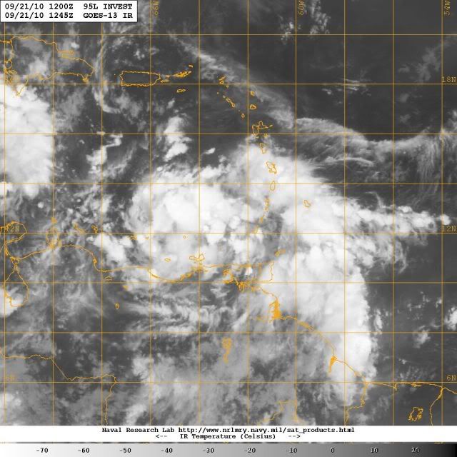
Well, imagery this morning speaks more of favorable upper-level environment but shows that 95L still has some consolidation to do. UW-CIMSS TCTrak showing low shear with anticyclonic flow aloft but somewhat scattered vorticity for those who like that method.

The question is always what's underneath? As above image shows, few obs available. From microwave, nothing greatly organized yet.

The question is always what's underneath? As above image shows, few obs available. From microwave, nothing greatly organized yet.
0 likes
-
Portastorm

- Storm2k Moderator
- Posts: 9787
- Age: 61
- Joined: Fri Jul 11, 2003 9:16 am
- Location: South Austin, TX
- Contact:
Re: ATL : INVEST 95L - Discussion
Ivanhater wrote:Interesting stat from jconsor (pro-met on eastern and S2K)
"only 2 of 32 tropical cyclones that formed or moved into the W. Caribbean (west of 77W) between Sep 20 and 30 had any east of north component to their motion while still in the Caribbean (this includes the motion after Sep 30 of cyclones that remained in the Caribbean). "
I was thinking based on the latest model runs that we in Texas were probably in the clear with this one ... until I read this!
0 likes
Re: ATL : INVEST 95L - Discussion
cycloneye wrote:What a change,from a small pouch PGI46L that was tracked for many days to now.
Indeed, Luis. Looks like the most favorable MJO pulse of the season is moving in...but wow what a change even from yesterday at this time...
This could be the beginning of yet another active phase.
MW
0 likes
Updating on the twitter now: http://www.twitter.com/@watkinstrack

I suspect only a touch north of due west next few days, into Central America but back out into the NW Caribbean in the end...thats when things get VERY worrying IMO...
I agree with everyone, this one maybe the memorable cat-5 this season IMO if it manages to miss Central America and slow down over the super high heat content...
I agree with everyone, this one maybe the memorable cat-5 this season IMO if it manages to miss Central America and slow down over the super high heat content...
0 likes
Personal Forecast Disclaimer:
The posts in this forum are NOT official forecast and should not be used as such. They are just the opinion of the poster and may or may not be backed by sound meteorological data. They are NOT endorsed by any professional institution or storm2k.org. For official information, please refer to the NHC and NWS products
The posts in this forum are NOT official forecast and should not be used as such. They are just the opinion of the poster and may or may not be backed by sound meteorological data. They are NOT endorsed by any professional institution or storm2k.org. For official information, please refer to the NHC and NWS products

Re: ATL : INVEST 95L - Discussion
Portastorm wrote:Ivanhater wrote:Interesting stat from jconsor (pro-met on eastern and S2K)
"only 2 of 32 tropical cyclones that formed or moved into the W. Caribbean (west of 77W) between Sep 20 and 30 had any east of north component to their motion while still in the Caribbean (this includes the motion after Sep 30 of cyclones that remained in the Caribbean). "
I was thinking based on the latest model runs that we in Texas were probably in the clear with this one ... until I read this!
oh it will go into CA I have no doubt about that but its whatever is left over getting back over water is going to be interesting.... where it tracks from there.....models still figuring out setup 7 days out....
0 likes
Hmmm its not clear cut it gets into CA, esp if it was develop a little faster and stronger then expected...could quite easily see it only just get inland and then be out as the upper trough comes in and stall as it gets left behind in weak steering currents, a classic set-up for a monster hurricane to develop.
0 likes
Personal Forecast Disclaimer:
The posts in this forum are NOT official forecast and should not be used as such. They are just the opinion of the poster and may or may not be backed by sound meteorological data. They are NOT endorsed by any professional institution or storm2k.org. For official information, please refer to the NHC and NWS products
The posts in this forum are NOT official forecast and should not be used as such. They are just the opinion of the poster and may or may not be backed by sound meteorological data. They are NOT endorsed by any professional institution or storm2k.org. For official information, please refer to the NHC and NWS products
-
tolakram
- Admin
- Posts: 19165
- Age: 60
- Joined: Sun Aug 27, 2006 8:23 pm
- Location: Florence, KY (name is Mark)
Re: ATL : INVEST 95L - Discussion
One thing interesting to note. When the disturbance that was to become Karl was down here SA has numerous storms inland with outflow boundaries regularly flowing into the disturbance. Today the conditions in SA are different with the flow coming from the NE instead of off land. Might make a difference.
0 likes
M a r k
- - - - -
Join us in chat: Storm2K Chatroom Invite. Android and IOS apps also available.
The posts in this forum are NOT official forecasts and should not be used as such. Posts are NOT endorsed by any professional institution or STORM2K.org. For official information and forecasts, please refer to NHC and NWS products.
- - - - -
Join us in chat: Storm2K Chatroom Invite. Android and IOS apps also available.
The posts in this forum are NOT official forecasts and should not be used as such. Posts are NOT endorsed by any professional institution or STORM2K.org. For official information and forecasts, please refer to NHC and NWS products.
Who is online
Users browsing this forum: No registered users and 38 guests