IDW24100
Australian Government Bureau of Meteorology
Western Australia
Tropical Cyclone Warning Centre
Media: The Standard Emergency Warning Signal should NOT be used with this
warning.
TOP PRIORITY FOR IMMEDIATE BROADCAST
TROPICAL CYCLONE ADVICE NUMBER 11
Issued at 5:46 pm WST on Tuesday 25 January 2011
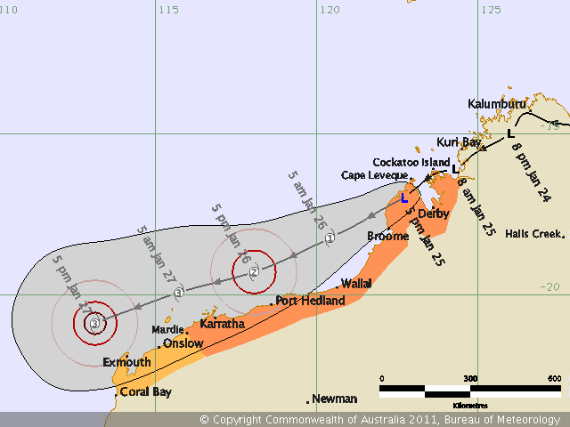
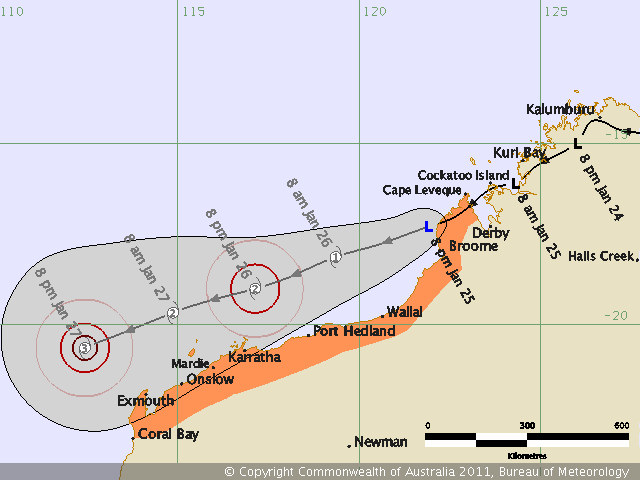
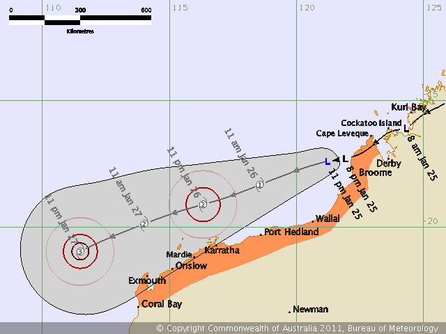
A Cyclone WARNING is current for coastal and island communities from Cockatoo
Island to Mardie.
A Cyclone WATCH is current for coastal and island communities from Mardie to
Coral Bay.
At 5:00 pm WST a tropical low was estimated to be near the Kimberley coast,
105 kilometres west northwest of Derby and
115 kilometres north northeast of Broome and
moving west southwest at 22 kilometres per hour.
The low continues to track to the southwest near the west Kimberley coast. The
low should reach cyclone intensity soon after it moves over open waters. As a
consequence gales may occur on the west Kimberley coast as early as this
evening. The communities most at risk of gales tonight are Lombadina, Cape
Leveque and Beagle Bay.
On Wednesday the system is expected to move steadily towards the southwest,
parallel to the Pilbara coast. Gales may occur in coastal areas of the Pilbara
during Wednesday and Thursday.
Heavy rain is expected in coastal parts of the Kimberley between Kalumburu and
Broome this evening and overnight. Localised stream rises are likely but
widespread flooding is not expected. During Wednesday and Thursday heavy
rainfall may develop along parts of the Pilbara coast but again, widespread
flooding is not expected.
FESA State Emergency Service (SES) advises of the following community alerts:
BLUE ALERT: People in coastal and island communities between Cape Leveque and
Karratha including the communities of Cape Leveque, Lombadina, Beagle Bay,
Broome, Bidyadanga, Sandfire Roadhouse, Wallal, Pardoo, De Grey, Port Hedland,
South Hedland, Whim Creek, Roebourne, Wickham, Point Samson, Dampier and
Karratha need to prepare for cyclonic weather and organise an emergency kit
including first aid kit, torch, portable radio, spare batteries, food and water.
ALL CLEAR WITH CAUTION: People in communities at Cockatoo Island, Koolan Island
and Derby are advised to proceed with caution.
Communities between Karratha and Coral Bay should listen for the next advice.
Details of Tropical Low at 5:00 pm WST:
.Centre located near...... 17.0 degrees South 122.7 degrees East
.Location accuracy........ within 55 kilometres
.Recent movement.......... towards the west southwest at 22 kilometres per hour
.Wind gusts near centre... 85 kilometres per hour
.Severity category........ below cyclone intensity
.Central pressure......... 995 hectoPascals
The next advice will be issued by 9:00 pm WST Tuesday 25 January.
Cyclone advices and State Emergency Service Community Alerts are available by
dialling 1300 659 210
A map showing the track of the cyclone is available at:
http://www.bom.gov.au/weather/cyclone