ATL: ARLENE - Remnants

Moderator: S2k Moderators

Message
Author
User avatar
cycloneye
Admin
Admin
Posts: 139409
Age: 67
Joined: Thu Oct 10, 2002 10:54 am
Location: San Juan, Puerto Rico

Re: ATL: INVEST 95L - Discussion

#61 Postby cycloneye » Tue Jun 28, 2011 6:40 am

Remains at 50%

TROPICAL WEATHER OUTLOOK
NWS NATIONAL HURRICANE CENTER MIAMI FL
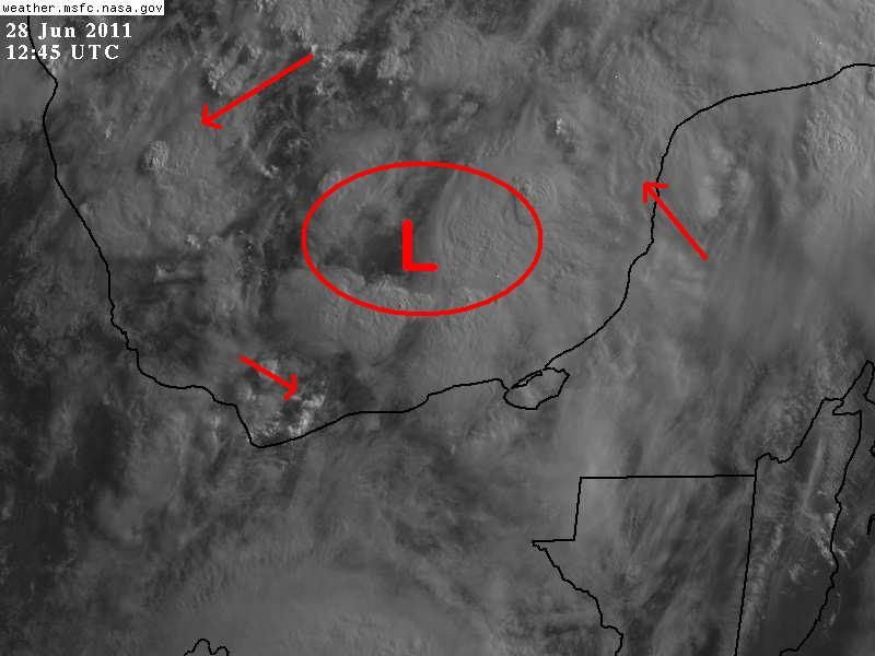
800 AM EDT TUE JUN 28 2011

FOR THE NORTH ATLANTIC...CARIBBEAN SEA AND THE GULF OF MEXICO...

CLOUDINESS AND SHOWERS ACCOMPANYING A BROAD AREA OF LOW PRESSURE
OVER THE BAY OF CAMPECHE HAVE CHANGED LITTLE IN ORGANIZATION
OVERNIGHT. UPPER-LEVEL WINDS ARE FORECAST TO GRADUALLY BECOME MORE
CONDUCIVE FOR DEVELOPMENT DURING THE NEXT COUPLE OF DAYS. THERE IS
A MEDIUM CHANCE...50 PERCENT...OF THIS SYSTEM BECOMING A TROPICAL
CYCLONE DURING THE NEXT 48 HOURS AS IT MOVES WEST-NORTHWESTWARD AT
5 TO 10 MPH. AN AIR FORCE RESERVE UNIT HURRICANE HUNTER PLANE IS
SCHEDULED TO INVESTIGATE THE AREA THIS AFTERNOON...IF NECESSARY.
REGARDLESS OF DEVELOPMENT...LOCALLY HEAVY RAINS AND GUSTY WINDS
SHOULD CONTINUE OVER PORTIONS OF EASTERN MEXICO OVER THE NEXT DAY
OR TWO.

ELSEWHERE...TROPICAL CYCLONE FORMATION IS NOT EXPECTED DURING THE
NEXT 48 HOURS.

$$
FORECASTER PASCH/BERG


Image
0 likes   
Visit the Caribbean-Central America Weather Thread where you can find at first post web cams,radars
and observations from Caribbean basin members Click Here

User avatar
wxman57
Moderator-Pro Met
Moderator-Pro Met
Posts: 22484
Age: 66
Joined: Sat Jun 21, 2003 8:06 pm
Location: Houston, TX (southwest)

Re: ATL: INVEST 95L - Discussion

#62 Postby wxman57 » Tue Jun 28, 2011 7:12 am

Still nothing there but a wave. No evidence of any LLC on surface obs. The wave is just kicking up some 15-25 kt winds across the region. Winds and seas will be higher near thunderstorms, that's it. In fact, the wave axis appears to be past 95W now, as is evident in surface obs and in MIMIC-TPW imagery. No need for any recon today, it will likely be canceled.

MIMIC loop - note the wave axis near 95W:
http://cimss.ssec.wisc.edu/tropic/real- ... /main.html

Here's a plot with surface obs and wave axis identified.
Image
0 likes   

User avatar
cycloneye
Admin
Admin
Posts: 139409
Age: 67
Joined: Thu Oct 10, 2002 10:54 am
Location: San Juan, Puerto Rico

Re: ATL: INVEST 95L - Discussion

#63 Postby cycloneye » Tue Jun 28, 2011 7:17 am

From the 8 AM Discussion:

...SPECIAL FEATURE...
BROAD LOW PRESSURE CONTINUES TO COVER THE SRN GULF OF MEXICO
WITH A 1007 MB SURFACE LOW LOCATED NEAR 20N93W...JUST E OF A
TROPICAL WAVE ALONG 94W/95W. CURRENTLY A LARGE AREA OF NUMEROUS
MODERATE/SCATTERED STRONG CONVECTION IS E OF THE LOW CENTER OVER
THE YUCATAN PENINSULA FROM 18N-22N BETWEEN 86W-93W. UPPER LEVEL
WINDS ARE CURRENTLY NOT FAVORABLE FOR DEVELOPMENT...BUT COULD
BECOME SO OVER THE NEXT COUPLE OF DAYS. REGARDLESS OF
DEVELOPMENT...SIGNIFICANT MOISTURE WILL REMAIN OVER THE SRN GULF
AND YUCATAN PENINSULA LIKELY SUPPORTING STRONG
SHOWERS/THUNDERSTORMS ALONG WITH GUSTY WINDS AS THE SYSTEM
DRIFTS WNW OVER THE NEXT 48 HOURS.
0 likes   
Visit the Caribbean-Central America Weather Thread where you can find at first post web cams,radars
and observations from Caribbean basin members Click Here

User avatar
GCANE
S2K Supporter
S2K Supporter
Posts: 10787
Joined: Mon Oct 22, 2007 8:03 am

Re: ATL: INVEST 95L - Discussion

#64 Postby GCANE » Tue Jun 28, 2011 7:18 am

Surface pressure at the BOC buoy could be going down.


Image
0 likes   

User avatar
NDG
S2K Supporter
S2K Supporter
Posts: 14934
Joined: Sun Jul 09, 2006 10:14 pm
Location: Orlando, FL

#65 Postby NDG » Tue Jun 28, 2011 7:31 am

I still see a nice cyclonic circulation, surface pressure is slightly lower than 24 hrs ago, my bet is that as the day goes on the Mexican stations along the southern coast of BOC will start reporting a more westerly winds.
0 likes   

User avatar
cycloneye
Admin
Admin
Posts: 139409
Age: 67
Joined: Thu Oct 10, 2002 10:54 am
Location: San Juan, Puerto Rico

Re: ATL: INVEST 95L - Discussion

#66 Postby cycloneye » Tue Jun 28, 2011 7:37 am

12z Best Track

AL, 95, 2011062812, , BEST, 0, 198N, 927W, 25, 1006, DB
0 likes   
Visit the Caribbean-Central America Weather Thread where you can find at first post web cams,radars
and observations from Caribbean basin members Click Here

User avatar
cycloneye
Admin
Admin
Posts: 139409
Age: 67
Joined: Thu Oct 10, 2002 10:54 am
Location: San Juan, Puerto Rico

Re: ATL: INVEST 95L - Models

#67 Postby cycloneye » Tue Jun 28, 2011 7:40 am

12z Models

Still SHIP has a minimal TS at landfall.

Code: Select all

WHXX01 KWBC 281236
CHGHUR
TROPICAL CYCLONE GUIDANCE MESSAGE
NWS NATIONAL HURRICANE CENTER MIAMI FL
1236 UTC TUE JUN 28 2011
 
DISCLAIMER...NUMERICAL MODELS ARE SUBJECT TO LARGE ERRORS.
PLEASE REFER TO NHC OFFICIAL FORECASTS FOR TROPICAL CYCLONE
AND SUBTROPICAL CYCLONE INFORMATION.
 
ATLANTIC OBJECTIVE AIDS FOR
 
DISTURBANCE INVEST (AL952011) 20110628 1200 UTC
 
        ...00 HRS...   ...12 HRS...   ...24 HRS. ..   ...36 HRS...
        110628  1200   110629  0000   110629  1200   110630  0000
 
         LAT    LON     LAT    LON     LAT    LON     LAT    LON
BAMS    19.8N  92.7W   20.5N  94.6W   20.9N  96.4W   21.0N  98.1W
BAMD    19.8N  92.7W   20.4N  94.0W   20.7N  95.3W   20.9N  96.8W
BAMM    19.8N  92.7W   20.4N  94.3W   20.7N  95.9W   20.9N  97.6W
LBAR    19.8N  92.7W   20.5N  94.1W   21.4N  95.9W   22.2N  97.9W
SHIP        25KTS          31KTS          38KTS          45KTS
DSHP        25KTS          31KTS          38KTS          36KTS
 
        ...48 HRS...   ...72 HRS...   ...96 HRS. ..   ..120 HRS...
        110630  1200   110701  1200   110702  1200   110703  1200
 
         LAT    LON     LAT    LON     LAT    LON     LAT    LON
BAMS    21.1N  99.7W   21.1N 102.8W   21.1N 106.5W   21.5N 110.2W
BAMD    21.0N  98.5W   21.0N 102.1W   21.2N 106.0W   21.6N 109.8W
BAMM    20.9N  99.3W   20.7N 102.8W   20.7N 106.6W   20.9N 110.6W
LBAR    23.0N 100.1W   24.4N 104.0W   26.8N 108.1W   29.7N 110.5W
SHIP        51KTS          64KTS          69KTS          65KTS
DSHP        30KTS          27KTS          30KTS          26KTS
 
         ...INITIAL CONDITIONS...
LATCUR =  19.8N LONCUR =  92.7W DIRCUR = 285DEG SPDCUR =   5KT
LATM12 =  19.5N LONM12 =  91.5W DIRM12 = 290DEG SPDM12 =   6KT
LATM24 =  19.0N LONM24 =  90.3W
WNDCUR =   25KT RMAXWD =   60NM WNDM12 =   20KT
CENPRS = 1006MB OUTPRS = 1010MB OUTRAD =  180NM SDEPTH =   M
RD34NE =    0NM RD34SE =    0NM RD34SW =    0NM RD34NW =   0NM
0 likes   
Visit the Caribbean-Central America Weather Thread where you can find at first post web cams,radars
and observations from Caribbean basin members Click Here

User avatar
cycloneye
Admin
Admin
Posts: 139409
Age: 67
Joined: Thu Oct 10, 2002 10:54 am
Location: San Juan, Puerto Rico

Re: ATL: INVEST 95L - Discussion

#68 Postby cycloneye » Tue Jun 28, 2011 7:48 am

First SSD Dvorak classification for 95L:

28/1215 UTC 20.4N 93.2W T1.0/1.0 95L -- Atlantic

http://www.ssd.noaa.gov/PS/TROP/tdpositions.html


The floater is now up for 95L.

Image

Image

Image
0 likes   
Visit the Caribbean-Central America Weather Thread where you can find at first post web cams,radars
and observations from Caribbean basin members Click Here

User avatar
NDG
S2K Supporter
S2K Supporter
Posts: 14934
Joined: Sun Jul 09, 2006 10:14 pm
Location: Orlando, FL

#69 Postby NDG » Tue Jun 28, 2011 8:19 am

First few vis sat loop this moring I am able to see W to E moving low clouds south of the suspect area of low pressure center, hard to see exactly where the center is, maybe as the day goes on it could be more noticeable.

Image
0 likes   

User avatar
GCANE
S2K Supporter
S2K Supporter
Posts: 10787
Joined: Mon Oct 22, 2007 8:03 am

Re: ATL: INVEST 95L - Discussion

#70 Postby GCANE » Tue Jun 28, 2011 8:35 am

Nice overshooting top just east of Veracruz.

http://www.tropicalatlantic.com/satelli ... &lon=-92.5
0 likes   

tolakram
Admin
Admin
Posts: 19172
Age: 60
Joined: Sun Aug 27, 2006 8:23 pm
Location: Florence, KY (name is Mark)

Re: ATL: INVEST 95L - Discussion

#71 Postby tolakram » Tue Jun 28, 2011 8:47 am

LOOP: http://wwwghcc.msfc.nasa.gov/cgi-bin/ge ... umframes=7

Looks like an LLC might be forming. As noted above you can see west moving storms near the northern coast.

Shear is decreasing rapidly.

Image
0 likes   
M a r k
- - - - -
Join us in chat: Storm2K Chatroom Invite. Android and IOS apps also available.

The posts in this forum are NOT official forecasts and should not be used as such. Posts are NOT endorsed by any professional institution or STORM2K.org. For official information and forecasts, please refer to NHC and NWS products.

User avatar
HURAKAN
Professional-Met
Professional-Met
Posts: 46086
Age: 37
Joined: Thu May 20, 2004 4:34 pm
Location: Key West, FL
Contact:

#72 Postby HURAKAN » Tue Jun 28, 2011 9:46 am

Image

based on the visible image loops, this is where the LLC appears to be forming
0 likes   

User avatar
wxman57
Moderator-Pro Met
Moderator-Pro Met
Posts: 22484
Age: 66
Joined: Sat Jun 21, 2003 8:06 pm
Location: Houston, TX (southwest)

Re:

#73 Postby wxman57 » Tue Jun 28, 2011 9:56 am

HURAKAN wrote:http://img830.imageshack.us/img830/6503/61357493.jpg

based on the visible image loops, this is where the LLC appears to be forming


I can see what looks like a small eddy there. It's rotating westward for now but should turn SW soon. Just to the north, the buoy reports a rising pressure and decreasing easterly wind. I don't think that eddy is a significant feature. I would look a little farther south for any LLC to form (19.8N/93.6W - just outside the bottom edge of that circle). Surface obs in southern Mexico still don't show any westerly winds, but it's possible there could be a small weak low to the north that isn't quite extending to the coast yet.

Recon will likely be canceled for today. Any development would be tomorrow, not long before it moves inland.
0 likes   

User avatar
Hylian Auree
Tropical Storm
Tropical Storm
Posts: 150
Age: 31
Joined: Thu Dec 02, 2010 7:01 pm
Location: Willemstad, Curaçao
Contact:

#74 Postby Hylian Auree » Tue Jun 28, 2011 9:57 am

Imo there has been a lot of improvement compared to yesterday. The spinning and convection seem to be consolidating, compared to yesterday's broad and disorganized gyre. Last night I was somewhat dubious about giving it a 50% chance of development, but if the trend + abating wind shear continues, I think we could be seeing code red by 2 PM.
0 likes   

User avatar
cycloneye
Admin
Admin
Posts: 139409
Age: 67
Joined: Thu Oct 10, 2002 10:54 am
Location: San Juan, Puerto Rico

Re: ATL: INVEST 95L - Recon

#75 Postby cycloneye » Tue Jun 28, 2011 10:04 am

Recon is a go for this afternoon. Here is todays TCPOD for Wednesday and Thursday.

Code: Select all

NOUS42 KNHC 281500
WEATHER RECONNAISSANCE FLIGHTS
CARCAH, NATIONAL HURRICANE CENTER, MIAMI, FL.
1100 AM EDT TUE 28 JUNE 2011
SUBJECT: TROPICAL CYCLONE PLAN OF THE DAY (TCPOD)
         VALID 29/1100Z TO 30/1100Z JUNE 2011
         TCPOD NUMBER.....11-028

I.  ATLANTIC REQUIREMENTS
    1. SUSPECT AREA (BAY OF CAMPECHE)
       FLIGHT ONE -- TEAL 72
       A. 29/1800Z
       B. AFXXX 02AAA INVEST
       C. 29/1500Z
       D. 21.0N 95.50W
       E. 29/1730Z TO 29/2200Z
       F. SFC TO 10,000 FT

       FLIGHT TWO -- TEAL 73
       A. 30/1200Z
       B. AFXXX 0301A CYCLONE
       C. 30/0915Z
       D. 21.5N 97.0W
       E. 30/1130Z TO 30/1600Z
       F. SFC TO 10,000 FT.

    2. OUTLOOK FOR SUCCEEDING DAY.....NEGATIVE.

0 likes   
Visit the Caribbean-Central America Weather Thread where you can find at first post web cams,radars
and observations from Caribbean basin members Click Here

User avatar
cycloneye
Admin
Admin
Posts: 139409
Age: 67
Joined: Thu Oct 10, 2002 10:54 am
Location: San Juan, Puerto Rico

Re: ATL: INVEST 95L - Discussion

#76 Postby cycloneye » Tue Jun 28, 2011 10:05 am

Hey Peeps,I just posted at the recon thread that the plane will go this afternoon as there are any remarks of cancellations.
0 likes   
Visit the Caribbean-Central America Weather Thread where you can find at first post web cams,radars
and observations from Caribbean basin members Click Here

User avatar
HURAKAN
Professional-Met
Professional-Met
Posts: 46086
Age: 37
Joined: Thu May 20, 2004 4:34 pm
Location: Key West, FL
Contact:

#77 Postby HURAKAN » Tue Jun 28, 2011 10:08 am

I think there could be a problem with the RECON info, both today and tomorrow say the same info.
0 likes   

User avatar
NDG
S2K Supporter
S2K Supporter
Posts: 14934
Joined: Sun Jul 09, 2006 10:14 pm
Location: Orlando, FL

#78 Postby NDG » Tue Jun 28, 2011 10:09 am

Recon still a go for this afternoon.
0 likes   

User avatar
cycloneye
Admin
Admin
Posts: 139409
Age: 67
Joined: Thu Oct 10, 2002 10:54 am
Location: San Juan, Puerto Rico

Re:

#79 Postby cycloneye » Tue Jun 28, 2011 10:11 am

HURAKAN wrote:I think there could be a problem with the RECON info, both today and tomorrow say the same info.


What do you mean Sandy?
0 likes   
Visit the Caribbean-Central America Weather Thread where you can find at first post web cams,radars
and observations from Caribbean basin members Click Here

User avatar
HURAKAN
Professional-Met
Professional-Met
Posts: 46086
Age: 37
Joined: Thu May 20, 2004 4:34 pm
Location: Key West, FL
Contact:

Re: Re:

#80 Postby HURAKAN » Tue Jun 28, 2011 10:13 am

cycloneye wrote:
HURAKAN wrote:I think there could be a problem with the RECON info, both today and tomorrow say the same info.


What do you mean Sandy?


today and tomorrow say the same thing:

SUSPECT AREA (BAY OF CAMPECHE)
FLIGHT ONE -- TEAL 72
A. 29/1800Z
B. AFXXX 02AAA INVEST
C. 29/1500Z
D. 21.0N 95.50W
E. 29/1730Z TO 29/2200Z
F. SFC TO 10,000 FT

FLIGHT TWO -- TEAL 73
A. 30/1200Z
B. AFXXX 0301A CYCLONE
C. 30/0915Z
D. 21.5N 97.0W
E. 30/1130Z TO 30/1600Z
F. SFC TO 10,000 FT.
0 likes   


Return to “2011”

Who is online

Users browsing this forum: No registered users and 4 guests