Remains 20%.
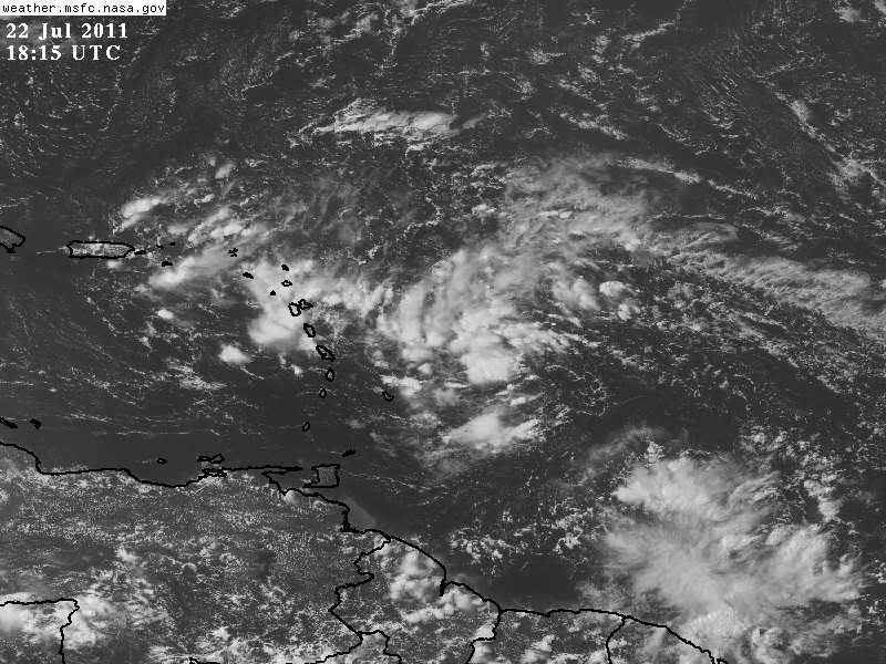
A TROPICAL WAVE LOCATED ABOUT 325 MILES EAST OF THE LESSER ANTILLES
IS PRODUCING SCATTERED SHOWERS AND THUNDERSTORMS. SLOW DEVELOPMENT
OF THIS SYSTEM IS POSSIBLE DURING THE NEXT COUPLE OF DAYS AS IT
MOVES WESTWARD TO WEST-NORTHWESTWARD AT 15 TO 20 MPH. THERE IS A
LOW CHANCE...20 PERCENT...OF THIS SYSTEM BECOMING A TROPICAL
CYCLONE DURING THE NEXT 48 HOURS. REGARDLESS OF DEVELOPMENT...
BRIEF PERIODS OF LOCALLY HEAVY RAINFALL AND GUSTY WINDS SHOULD
SPREAD ACROSS PORTIONS OF THE LESSER ANTILLES THIS AFTERNOON AND
TONIGHT.
ATL: DON - Remnant - Discussion
Moderator: S2k Moderators
-
Florida1118
- Category 5

- Posts: 1805
- Age: 27
- Joined: Sat Jun 19, 2010 12:57 pm
- Location: Tampa, Florida
Re: ATL: INVEST 90L - Discussion
0 likes
-
SouthFloridawx

- S2K Supporter

- Posts: 8344
- Age: 45
- Joined: Tue Jul 26, 2005 1:16 am
- Location: Sarasota, FL
- Contact:
Re: ATL: INVEST 90L - Discussion
Looks like there is a lot less dry air than earlier. Convection will probably continue to expand further and further.

0 likes


-
South Texas Storms

- Professional-Met

- Posts: 4018
- Joined: Thu Jun 24, 2010 12:28 am
- Location: Houston, TX
Re: ATL: INVEST 90L - Discussion
0 likes

Re: ATL: INVEST 90L - Discussion
South Texas Storms wrote::uarrow: Yeah it brings it into the Florida Straits in 96 hours. Is it stronger than the 0z run so far?
Yes, it shows the vorticity a little stronger than last night's run.
0 likes
-
Ivanhater

- Storm2k Moderator

- Posts: 10852
- Age: 37
- Joined: Fri Jul 01, 2005 8:25 am
- Location: Pensacola
Re: ATL: INVEST 90L - Discussion
Pretty decent vort sig on the 12z Euro....could spin up at any time. Surface convergence is really now.
[img]
Uploaded with ImageShack.us[/img]
[img]

Uploaded with ImageShack.us[/img]
0 likes
Michael

-
Ivanhater
- Storm2k Moderator
- Posts: 10852
- Age: 37
- Joined: Fri Jul 01, 2005 8:25 am
- Location: Pensacola
Re: ATL: INVEST 90L - Models
SHIPS brings this to a Hurricane
WHXX01 KWBC 221824
CHGHUR
TROPICAL CYCLONE GUIDANCE MESSAGE
NWS NATIONAL HURRICANE CENTER MIAMI FL
1824 UTC FRI JUL 22 2011
DISCLAIMER...NUMERICAL MODELS ARE SUBJECT TO LARGE ERRORS.
PLEASE REFER TO NHC OFFICIAL FORECASTS FOR TROPICAL CYCLONE
AND SUBTROPICAL CYCLONE INFORMATION.
ATLANTIC OBJECTIVE AIDS FOR
DISTURBANCE INVEST (AL902011) 20110722 1800 UTC
...00 HRS... ...12 HRS... ...24 HRS. .. ...36 HRS...
110722 1800 110723 0600 110723 1800 110724 0600
LAT LON LAT LON LAT LON LAT LON
BAMS 14.1N 56.2W 14.9N 59.4W 15.9N 62.8W 17.1N 66.4W
BAMD 14.1N 56.2W 15.0N 59.3W 15.8N 62.1W 16.6N 64.7W
BAMM 14.1N 56.2W 14.7N 59.5W 15.5N 62.9W 16.3N 66.2W
LBAR 14.1N 56.2W 14.5N 59.4W 15.2N 62.9W 15.7N 66.3W
SHIP 20KTS 23KTS 28KTS 35KTS
DSHP 20KTS 23KTS 28KTS 35KTS
...48 HRS... ...72 HRS... ...96 HRS. .. ..120 HRS...
110724 1800 110725 1800 110726 1800 110727 1800
LAT LON LAT LON LAT LON LAT LON
BAMS 18.4N 70.0W 20.3N 76.6W 21.6N 81.4W 23.2N 85.1W
BAMD 17.4N 67.2W 18.8N 71.4W 20.3N 74.7W 21.6N 77.8W
BAMM 17.4N 69.4W 18.9N 74.9W 19.9N 79.3W 21.3N 83.4W
LBAR 16.4N 69.4W 18.1N 73.9W 20.5N 76.4W 22.8N 78.4W
SHIP 43KTS 55KTS 65KTS 69KTS
DSHP 43KTS 51KTS 60KTS 65KTS
...INITIAL CONDITIONS...
LATCUR = 14.1N LONCUR = 56.2W DIRCUR = 280DEG SPDCUR = 16KT
LATM12 = 13.5N LONM12 = 53.1W DIRM12 = 281DEG SPDM12 = 16KT
LATM24 = 12.8N LONM24 = 49.8W
WNDCUR = 20KT RMAXWD = 40NM WNDM12 = 20KT
CENPRS = 1012MB OUTPRS = 1015MB OUTRAD = 175NM SDEPTH = S
RD34NE = 0NM RD34SE = 0NM RD34SW = 0NM RD34NW = 0NM
$$
NNNN
0 likes
Michael

-
Ivanhater
- Storm2k Moderator
- Posts: 10852
- Age: 37
- Joined: Fri Jul 01, 2005 8:25 am
- Location: Pensacola
Re: ATL: INVEST 90L - Discussion
Putting on a show today...vorticity and surface convergence continues to increase


0 likes
Michael
-
South Texas Storms
- Professional-Met
- Posts: 4018
- Joined: Thu Jun 24, 2010 12:28 am
- Location: Houston, TX
Re: ATL: INVEST 90L - Discussion
0 likes
-
PTrackerLA

- Category 5
- Posts: 5248
- Age: 40
- Joined: Thu Oct 10, 2002 8:40 pm
- Location: Lafayette, LA
-
HurricaneBrain

- S2K Supporter
- Posts: 430
- Joined: Thu Jun 30, 2011 2:07 pm
- Location: Beaumont, TX
Re: Re:
CourierPR wrote:This system is not even past the Antilles and the Gulfcasting has begun.HurricaneBrain wrote:Should end up between Tampico and the TX/LA coast.
I'm basing that on model guidance and the massive ridge that has caused so many tropical cyclones in the BoC lately. I'm not "Gulfcasting".
0 likes


Re: ATL: INVEST 90L - Discussion
Ships brings it to a hurricane that is predicted to go where? 
0 likes
Who is online
Users browsing this forum: No registered users and 6 guests