SIO: DIANNE (16U/16S) - Tropical Cyclone

Moderator: S2k Moderators

Message
Author
User avatar
HURAKAN
Professional-Met
Professional-Met
Posts: 46086
Age: 37
Joined: Thu May 20, 2004 4:34 pm
Location: Key West, FL
Contact:

SIO: DIANNE (16U/16S) - Tropical Cyclone

#1 Postby HURAKAN » Sat Feb 12, 2011 9:31 am

Image

Image

Latest consensus
Last edited by HURAKAN on Wed Feb 16, 2011 8:08 am, edited 3 times in total.
0 likes   

User avatar
HURAKAN
Professional-Met
Professional-Met
Posts: 46086
Age: 37
Joined: Thu May 20, 2004 4:34 pm
Location: Key West, FL
Contact:

#2 Postby HURAKAN » Sat Feb 12, 2011 9:31 am

Another low may develop north of the Pilbara coast late on Saturday or on
Sunday. This system may develop into a tropical cyclone on Tuesday or later in
the week.

Likelihood of this system being a tropical cyclone in the Western Region:
Sunday :Low
Monday :Low
Tuesday :Moderate
0 likes   

User avatar
KWT
Category 5
Category 5
Posts: 31390
Joined: Tue Aug 17, 2004 11:02 am
Location: UK!!!

#3 Postby KWT » Sat Feb 12, 2011 10:55 am

ECM takes a while to get this thing going though it does develop something fairly strong in the 120-168hrs range.
0 likes   
Personal Forecast Disclaimer:
The posts in this forum are NOT official forecast and should not be used as such. They are just the opinion of the poster and may or may not be backed by sound meteorological data. They are NOT endorsed by any professional institution or storm2k.org. For official information, please refer to the NHC and NWS products

User avatar
Chacor
Category 5
Category 5
Posts: 10229
Joined: Mon Oct 02, 2006 10:43 pm
Location: Singapore

#4 Postby Chacor » Sat Feb 12, 2011 10:43 pm

Image

Watch out, Perth...
0 likes   

User avatar
HURAKAN
Professional-Met
Professional-Met
Posts: 46086
Age: 37
Joined: Thu May 20, 2004 4:34 pm
Location: Key West, FL
Contact:

#5 Postby HURAKAN » Sun Feb 13, 2011 1:39 am

Image

Latest infrared
0 likes   

Rod Hagen
Tropical Storm
Tropical Storm
Posts: 237
Joined: Fri Sep 23, 2005 6:22 am
Location: Lives in Melbourne, works in N Queensland

Re: SIO: Invest 97S

#6 Postby Rod Hagen » Sun Feb 13, 2011 3:17 am

Do any other models suggest, like the euro, that it will head back to the coast around Perth in a week's time, or do they see it disappearing off to the west?
0 likes   

User avatar
KWT
Category 5
Category 5
Posts: 31390
Joined: Tue Aug 17, 2004 11:02 am
Location: UK!!!

#7 Postby KWT » Sun Feb 13, 2011 8:37 am

I suspect most keep it away from land though I've not looked recently. FWIW the ECM 00z also keeps it away from land.

The models aren't super agressive on it though they do strengthen it slowly over the next few days.
0 likes   
Personal Forecast Disclaimer:
The posts in this forum are NOT official forecast and should not be used as such. They are just the opinion of the poster and may or may not be backed by sound meteorological data. They are NOT endorsed by any professional institution or storm2k.org. For official information, please refer to the NHC and NWS products

Grifforzer
Category 1
Category 1
Posts: 418
Joined: Thu Feb 26, 2009 11:27 pm

#8 Postby Grifforzer » Sun Feb 13, 2011 5:29 pm

Tropical Cyclone Warning Center Perth
TROPICAL CYCLONE OUTLOOK
Forecast for area south of 10S between 90E-125E
2:00 PM WST February 13 2011
=====================================

Another low is developing north of the Pilbara coast near 14S 118E and will move slowly west over the next 24 to 48 hours and slowly deepen. This system may develop into a tropical cyclone on Tuesday or later in the week.

Tropical Cyclone Formation Potential
====================================

Monday: Low
Tuesday: Moderate
Wednesday: Moderate
0 likes   

User avatar
HURAKAN
Professional-Met
Professional-Met
Posts: 46086
Age: 37
Joined: Thu May 20, 2004 4:34 pm
Location: Key West, FL
Contact:

#9 Postby HURAKAN » Sun Feb 13, 2011 11:08 pm

Potential Cyclones:
At 11am WST a low was located near 16S 119E, about 480 kilometres north of Port
Hedland and moving towards the west southwest. Over the next three days the low
is expected to move towards the west southwest and so by Thursday is expected to
be located to the northwest of Exmouth. The low may develop into a tropical
cyclone on Thursday or later in the week.

Likelihood of this system being a tropical cyclone in the Western Region:
Tuesday :Low
Wednesday :Moderate
Thursday :High
0 likes   

User avatar
KWT
Category 5
Category 5
Posts: 31390
Joined: Tue Aug 17, 2004 11:02 am
Location: UK!!!

#10 Postby KWT » Mon Feb 14, 2011 5:01 am

Looking increasingly likely this one will develop, ECM takes it slowly SW/SSW and becomes quite a large looking system before moving westwards and weakening.
0 likes   
Personal Forecast Disclaimer:
The posts in this forum are NOT official forecast and should not be used as such. They are just the opinion of the poster and may or may not be backed by sound meteorological data. They are NOT endorsed by any professional institution or storm2k.org. For official information, please refer to the NHC and NWS products

User avatar
HURAKAN
Professional-Met
Professional-Met
Posts: 46086
Age: 37
Joined: Thu May 20, 2004 4:34 pm
Location: Key West, FL
Contact:

#11 Postby HURAKAN » Mon Feb 14, 2011 6:31 am

AN AREA OF CONVECTION HAS DEVELOPED NEAR 16.9S 118.2E,
APPROXIMATELY 205 NM NORTH OF PORT HEDLAND. ANIMATED MULTISPECTRAL
SATELLITE IMAGERY AND A 140535Z AMSR-E IMAGE DEPICT A BROAD, BUT
CONSOLIDATING LOW-LEVEL CIRCULATION CENTER (LLCC) WITH FORMATIVE
DEEP CONVECTIVE BANDING OVER THE SOUTHERN SEMI-CIRCLE. A 140050Z
ASCAT PARTIAL IMAGE SUPPORTED A STRENGTHENING LLCC WITH 20-25 KNOT
WINDS OVER THE EASTERN SEMI-CIRCLE. ANIMATED WATER VAPOR IMAGERY
INDICATES GOOD OVERALL OUTFLOW OVER THE SYSTEM. MODEL GUIDANCE HAS
BEEN CONSISTENT IN DEVELOPING THIS SYSTEM IN THE NEXT 2-3 DAYS.
MAXIMUM SUSTAINED SURFACE WINDS ARE ESTIMATED AT 20 TO 25 KNOTS.
MINIMUM SEA LEVEL PRESSURE IS ESTIMATED TO BE NEAR 1002 MB. THE
POTENTIAL FOR THE DEVELOPMENT OF A SIGNIFICANT TROPICAL CYCLONE
WITHIN THE NEXT 24 HOURS IS FAIR.
0 likes   

User avatar
HURAKAN
Professional-Met
Professional-Met
Posts: 46086
Age: 37
Joined: Thu May 20, 2004 4:34 pm
Location: Key West, FL
Contact:

#12 Postby HURAKAN » Mon Feb 14, 2011 6:32 am

Image

Latest
0 likes   

User avatar
wxman57
Moderator-Pro Met
Moderator-Pro Met
Posts: 22480
Age: 66
Joined: Sat Jun 21, 2003 8:06 pm
Location: Houston, TX (southwest)

Re: SIO: Invest 97S

#13 Postby wxman57 » Mon Feb 14, 2011 3:59 pm

Certainly appears to be a TD now. Dvorak 2.0 to 2.5. Really wrapping up. Still no mention of it at NOAA/CIMSS as far as Dvorak rating.
0 likes   

User avatar
HURAKAN
Professional-Met
Professional-Met
Posts: 46086
Age: 37
Joined: Thu May 20, 2004 4:34 pm
Location: Key West, FL
Contact:

#14 Postby HURAKAN » Mon Feb 14, 2011 4:49 pm

Image

Latest
0 likes   

User avatar
HURAKAN
Professional-Met
Professional-Met
Posts: 46086
Age: 37
Joined: Thu May 20, 2004 4:34 pm
Location: Key West, FL
Contact:

#15 Postby HURAKAN » Mon Feb 14, 2011 10:21 pm

Image

Latest
0 likes   

User avatar
HURAKAN
Professional-Met
Professional-Met
Posts: 46086
Age: 37
Joined: Thu May 20, 2004 4:34 pm
Location: Key West, FL
Contact:

#16 Postby HURAKAN » Mon Feb 14, 2011 10:28 pm

Image

WTXS21 PGTW 150230
MSGID/GENADMIN/NAVMARFCSTCEN PEARL HARBOR HI/JTWC//
SUBJ/TROPICAL CYCLONE FORMATION ALERT//
RMKS/
1. FORMATION OF A SIGNIFICANT TROPICAL CYCLONE IS POSSIBLE WITHIN
180 NM EITHER SIDE OF A LINE FROM 18.6S 113.8E TO 24.2S 108.0E
WITHIN THE NEXT 12 TO 24 HOURS. AVAILABLE DATA DOES NOT JUSTIFY
ISSUANCE OF NUMBERED TROPICAL CYCLONE WARNINGS AT THIS TIME. WINDS IN
THE AREA ARE ESTIMATED TO BE 20 TO 25 KNOTS. METSAT IMAGERY AT
150130Z INDICATES THAT A CIRCULATION CENTER IS LOCATED NEAR 18.9S
113.2E. THE SYSTEM IS MOVING WEST-SOUTHWESTWARD AT 15 KNOTS.
2. REMARKS: THE AREA OF CONVECTION PREVIOUSLY LOCATED NEAR 18.0S
117.4E IS NOW LOCATED NEAR 18.9S 113.2E, APPROXIMATELY 195 NM NORTH-
NORTHWEST OF LEARMONTH, AUSTRALIA. ANIMATED WATER VAPOR IMAGERY SHOWS
THE SYSTEM HAS RAPIDLY CONSOLIDATED OVER THE PAST 12 HOURS WITH
FORMATIVE BANDING ALONG THE SOUTHERN SEMICIRCLE. THIS IS SUPPORTED BY
A 142135Z SSMIS MICROWAVE IMAGERY. THE SAME ANIMATION SHOWS GOOD
EQUATORWARD OUTFLOW. UPPER LEVEL ANALYSIS INDICATES THE SYSTEM IS
JUST TO THE NORTH OF A RIDGE AXIS IN AN AREA OF LOW TO MODERATE
VERTICAL WIND SHEAR. RECENT SCATTEROMETRY PASSES OUTLINE A
WELL-DEFINED, ALBEIT BROAD, LOW LEVEL CIRCULATION CENTER WITH 20-25
KNOT UNFLAGGED WINDS AROUND THE OUTER RIM. NUMERICAL MODELS INCLUDING
ECMWF, NOGAPS, AND GFS ALL INDICATE SIGNIFICANT DEVELOPMENT OVER THE
NEXT 12-24 HOURS. MAXIMUM SUSTAINED WINDS ARE ESTIMATED AT 20-25
KNOTS AND MINIMUM SEA LEVEL PRESSURE AT 1003 MB. THE POTENTIAL FOR
THE DEVELOPMENT OF A SIGNIFICANT TROPICAL CYCLONE WITHIN THE NEXT 24
HOURS ID UPGRADED TO GOOD.
3. THIS ALERT WILL BE REISSUED, UPGRADED TO WARNING OR CANCELLED BY
160230Z.//
NNNN
0 likes   

User avatar
HURAKAN
Professional-Met
Professional-Met
Posts: 46086
Age: 37
Joined: Thu May 20, 2004 4:34 pm
Location: Key West, FL
Contact:

#17 Postby HURAKAN » Mon Feb 14, 2011 10:43 pm

Image

Latest consensus
0 likes   

User avatar
Extratropical94
Professional-Met
Professional-Met
Posts: 3535
Age: 29
Joined: Wed Oct 20, 2010 6:36 am
Location: Hamburg, Germany
Contact:

#18 Postby Extratropical94 » Tue Feb 15, 2011 1:46 am

IDW10800
Australian Government Bureau of Meteorology
Western Australia

Tropical Cyclone three-day outlook for the Western Region
Issued at 2:20pm WST on Tuesday the 15th of February 2011
Valid until midnight WST Friday

[...]

Potential Cyclones:
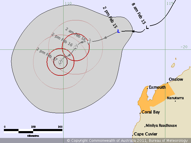
At 2pm WST a developing tropical low [16U] was located near 19.1S 112.7E, about
350 kilometres north northwest of Exmouth and moving towards the west southwest
at 24 kilometres per hour. The low is in a favourable environment for
development and is likely to develop into a tropical cyclone on Wednesday.

Likelihood of this system being a tropical cyclone in the Western Region:
Wednesday :High
Thursday :High
Friday :High

[...]

Here it is, 16U :D
I was wondering because the BOM only had 17U on their map
0 likes   
54° 11' 59'' N, 9° 9' 20'' E
Boomer Sooner!
Go Broncos! Go Cards! Go Niners!
- Daniel

User avatar
Craiga74
Tropical Low
Tropical Low
Posts: 42
Age: 49
Joined: Thu Feb 21, 2008 8:59 am
Location: Port Hedland, Australia
Contact:

Re: SIO: Invest 97S

#19 Postby Craiga74 » Tue Feb 15, 2011 3:29 am

Image
0 likes   

User avatar
HURAKAN
Professional-Met
Professional-Met
Posts: 46086
Age: 37
Joined: Thu May 20, 2004 4:34 pm
Location: Key West, FL
Contact:

#20 Postby HURAKAN » Tue Feb 15, 2011 5:43 am

Image

Latest
0 likes   


Return to “2011”

Who is online

Users browsing this forum: No registered users and 99 guests