SIO: CARLOS (17U/15S) - Tropical Cyclone

Moderator: S2k Moderators

Message
Author
User avatar
HURAKAN
Professional-Met
Professional-Met
Posts: 46086
Age: 37
Joined: Thu May 20, 2004 4:34 pm
Location: Key West, FL
Contact:

#81 Postby HURAKAN » Sun Feb 20, 2011 3:20 pm

Image

Latest track
0 likes   

User avatar
HURAKAN
Professional-Met
Professional-Met
Posts: 46086
Age: 37
Joined: Thu May 20, 2004 4:34 pm
Location: Key West, FL
Contact:

#82 Postby HURAKAN » Sun Feb 20, 2011 3:21 pm

Image

NRL : 35 knots
0 likes   

User avatar
HURAKAN
Professional-Met
Professional-Met
Posts: 46086
Age: 37
Joined: Thu May 20, 2004 4:34 pm
Location: Key West, FL
Contact:

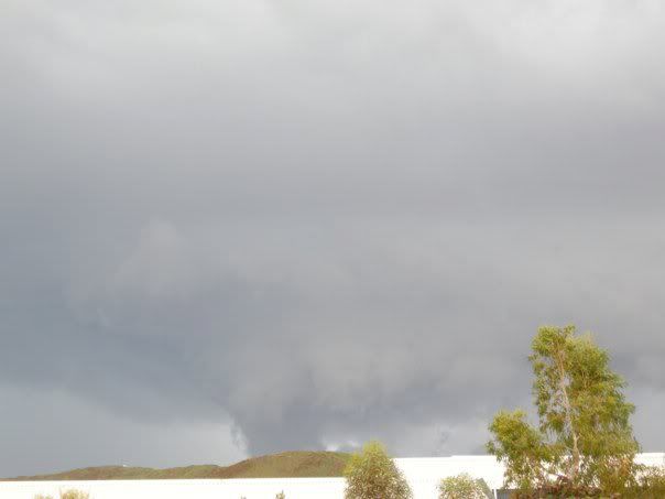
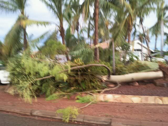
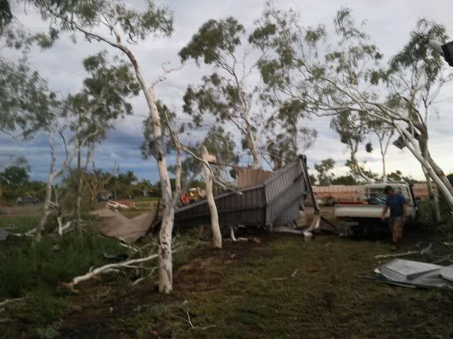
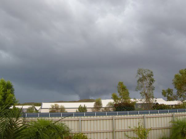
#83 Postby HURAKAN » Sun Feb 20, 2011 4:17 pm

WTXS32 PGTW 202100
MSGID/GENADMIN/NAVMARFCSTCEN PEARL HARBOR HI/JTWC//
SUBJ/TROPICAL CYCLONE 15S (CARLOS) WARNING NR 005//
REF/A/NAVMARFCSTCEN PEARL HARBOR HI/200421Z//
AMPN/TROPICAL CYCLONE FORMATION ALERT//
RMKS/
1. TROPICAL CYCLONE 15S (CARLOS) WARNING NR 005
01 ACTIVE TROPICAL CYCLONE IN SOUTHIO
MAX SUSTAINED WINDS BASED ON ONE-MINUTE AVERAGE
WIND RADII VALID OVER OPEN WATER ONLY
---
WARNING POSITION:
201800Z --- NEAR 17.5S 122.0E
MOVEMENT PAST SIX HOURS - 250 DEGREES AT 19 KTS
POSITION ACCURATE TO WITHIN 025 NM
POSITION BASED ON CENTER LOCATED BY A COMBINATION OF
SATELLITE, RADAR AND SYNOPTIC DATA
PRESENT WIND DISTRIBUTION:
MAX SUSTAINED WINDS - 035 KT, GUSTS 045 KT
WIND RADII VALID OVER OPEN WATER ONLY
REPEAT POSIT: 17.5S 122.0E
---
FORECASTS:
12 HRS, VALID AT:
210600Z --- 18.6S 119.6E
MAX SUSTAINED WINDS - 040 KT, GUSTS 050 KT
WIND RADII VALID OVER OPEN WATER ONLY
RADIUS OF 034 KT WINDS - 045 NM NORTHEAST QUADRANT
055 NM SOUTHEAST QUADRANT
050 NM SOUTHWEST QUADRANT
045 NM NORTHWEST QUADRANT
VECTOR TO 24 HR POSIT: 240 DEG/ 13 KTS
---
24 HRS, VALID AT:
211800Z --- 19.9S 117.1E
MAX SUSTAINED WINDS - 050 KT, GUSTS 065 KT
WIND RADII VALID OVER OPEN WATER ONLY
RADIUS OF 034 KT WINDS - 060 NM NORTHEAST QUADRANT
070 NM SOUTHEAST QUADRANT
065 NM SOUTHWEST QUADRANT
060 NM NORTHWEST QUADRANT
VECTOR TO 36 HR POSIT: 245 DEG/ 11 KTS
---
36 HRS, VALID AT:
220600Z --- 20.9S 115.0E
MAX SUSTAINED WINDS - 060 KT, GUSTS 075 KT
WIND RADII VALID OVER OPEN WATER ONLY
RADIUS OF 050 KT WINDS - 035 NM NORTHEAST QUADRANT
040 NM SOUTHEAST QUADRANT
035 NM SOUTHWEST QUADRANT
035 NM NORTHWEST QUADRANT
RADIUS OF 034 KT WINDS - 075 NM NORTHEAST QUADRANT
085 NM SOUTHEAST QUADRANT
080 NM SOUTHWEST QUADRANT
075 NM NORTHWEST QUADRANT
VECTOR TO 48 HR POSIT: 240 DEG/ 10 KTS
---
EXTENDED OUTLOOK:
48 HRS, VALID AT:
221800Z --- 21.8S 113.2E
MAX SUSTAINED WINDS - 070 KT, GUSTS 085 KT
WIND RADII VALID OVER OPEN WATER ONLY
RADIUS OF 064 KT WINDS - 025 NM NORTHEAST QUADRANT
025 NM SOUTHEAST QUADRANT
025 NM SOUTHWEST QUADRANT
025 NM NORTHWEST QUADRANT
RADIUS OF 050 KT WINDS - 040 NM NORTHEAST QUADRANT
045 NM SOUTHEAST QUADRANT
040 NM SOUTHWEST QUADRANT
040 NM NORTHWEST QUADRANT
RADIUS OF 034 KT WINDS - 090 NM NORTHEAST QUADRANT
100 NM SOUTHEAST QUADRANT
095 NM SOUTHWEST QUADRANT
090 NM NORTHWEST QUADRANT
VECTOR TO 72 HR POSIT: 240 DEG/ 09 KTS
---
72 HRS, VALID AT:
231800Z --- 23.6S 109.9E
MAX SUSTAINED WINDS - 075 KT, GUSTS 090 KT
WIND RADII VALID OVER OPEN WATER ONLY
RADIUS OF 064 KT WINDS - 025 NM NORTHEAST QUADRANT
025 NM SOUTHEAST QUADRANT
025 NM SOUTHWEST QUADRANT
025 NM NORTHWEST QUADRANT
RADIUS OF 050 KT WINDS - 040 NM NORTHEAST QUADRANT
045 NM SOUTHEAST QUADRANT
040 NM SOUTHWEST QUADRANT
040 NM NORTHWEST QUADRANT
RADIUS OF 034 KT WINDS - 095 NM NORTHEAST QUADRANT
105 NM SOUTHEAST QUADRANT
100 NM SOUTHWEST QUADRANT
095 NM NORTHWEST QUADRANT
VECTOR TO 96 HR POSIT: 225 DEG/ 09 KTS
---
LONG RANGE OUTLOOK:
NOTE...ERRORS FOR TRACK HAVE AVERAGED NEAR 250 NM
ON DAY 4 AND 350 NM ON DAY 5... AND FOR INTENSITY
NEAR 20 KT EACH DAY.
---
96 HRS, VALID AT:
241800Z --- 26.2S 106.9E
MAX SUSTAINED WINDS - 065 KT, GUSTS 080 KT
WIND RADII VALID OVER OPEN WATER ONLY
VECTOR TO 120 HR POSIT: 200 DEG/ 10 KTS
---
120 HRS, VALID AT:
251800Z --- 30.0S 105.1E
MAX SUSTAINED WINDS - 050 KT, GUSTS 065 KT
WIND RADII VALID OVER OPEN WATER ONLY
BECOMING EXTRATROPICAL
---
REMARKS:
202100Z POSITION NEAR 17.8S 121.4E.
TROPICAL CYCLONE (TC) 15S (CARLOS), LOCATED APPROXIMATELY 530 NM
EAST-NORTHEAST OF LEARMONTH, AUSTRALIA, HAS TRACKED WEST-
SOUTHWESTWARD AT APPROXIMATELY 19 KNOTS OVER THE PAST SIX HOURS. A
RECENT DVORAK T-NUMBER ESTIMATE OF 2.5 FROM PGTW AND SYNOPTIC
PRESSURE OBSERVATIONS NEAR 996 MB INDICATE THAT TC 15S HAS
INTENSIFIED INTO A 35 KNOT CYCLONE. ALTHOUGH TC 15S HAS TRACKED
RAPIDLY WEST-SOUTHWESTWARD DURING THE PAST TWELVE HOURS, IT IS
LIKELY TO SLOW A BIT OVER THE UPCOMING SIX TO TWELVE HOURS AS IT
CONTINUES TO REDEVELOP OVER WATER. THE CURRENT POSITION IS BASED ON
SATELLITE FIXES FROM PGTW AND APRF, SYNOPTIC WIND AND PRESSURE
OBSERVATIONS, AND RADAR IMAGERY FROM BROOME. TC 15S IS TRACKING
ALONG THE NORTH PERIPHERY OF A SUBTROPICAL RIDGE SITUATED OVER
CENTRAL AUSTRALIA. THIS RIDGE IS EXPECTED TO REMAIN THE DOMINANT
STEERING MECHANISM THROUGHOUT THE FORECAST PERIOD, CARRYING THE
CYCLONE GENERALLY WEST-SOUTHWESTWARD UNTIL TAU 72. THEREAFTER, THE
CYCLONE IS EXPECTED TO TURN POLEWARD AHEAD OF AN APPROACHING MID-
LATITUDE TROUGH AND BEGIN EXTRATROPICAL TRANSITION BY TAU 120. TC
15S IS EXPECTED TO INTENSIFY SLOWLY IN THE NEAR TO MEDIUM RANGE AS
SOMEWHAT UNFAVORABLE EASTERLY VERTICAL WIND SHEAR LIMITS THE IMPACT
OF PASSAGE OVER A VERY WARM SEA SURFACE AND STRONG DIFFLUENCE ALOFT.
ASIDE FROM THE GFDN, WHICH IS DEPICTING A NEARLY STRAIGHT WESTWARD
TRACK, THE NUMERICAL MODELS ARE IN FAIR AGREEMENT WITH THE CURRENT
FORECAST AND THE FORECAST TRACK LIES SLIGHTLY SOUTH OF THE MODEL
CONSENSUS. THIS WARNING SUPERSEDES AND CANCELS REF A, NAVMARFCSTCEN
200421Z FEB 11 TROPICAL CYCLONE FORMATION ALERT (WTXS21 PGTW
200430). MAXIMUM SIGNIFICANT WAVE HEIGHT AT 201800Z IS 11 FEET. NEXT
WARNINGS AT 210900Z AND 212100Z. REFER TO TROPICAL CYCLONE 16S
(DIANNE) WARNINGS (WTXS33 PGTW)FOR TWELVE-HOURLY UPDATES.//
NNNN
0 likes   

User avatar
HURAKAN
Professional-Met
Professional-Met
Posts: 46086
Age: 37
Joined: Thu May 20, 2004 4:34 pm
Location: Key West, FL
Contact:

#84 Postby HURAKAN » Sun Feb 20, 2011 4:19 pm

Image

Track
0 likes   

User avatar
HURAKAN
Professional-Met
Professional-Met
Posts: 46086
Age: 37
Joined: Thu May 20, 2004 4:34 pm
Location: Key West, FL
Contact:

#85 Postby HURAKAN » Sun Feb 20, 2011 5:42 pm

20/2032 UTC 17.4S 122.0E T2.5/2.5 CARLOS -- Southeast Indian

35 knots
0 likes   

User avatar
HURAKAN
Professional-Met
Professional-Met
Posts: 46086
Age: 37
Joined: Thu May 20, 2004 4:34 pm
Location: Key West, FL
Contact:

#86 Postby HURAKAN » Sun Feb 20, 2011 6:38 pm

Australian Government Bureau of Meteorology
Western Australia
Tropical Cyclone Warning Centre

Media: The Standard Emergency Warning Signal should NOT be used with this
warning.

TOP PRIORITY FOR IMMEDIATE BROADCAST

TROPICAL CYCLONE ADVICE NUMBER 36
Issued at 6:02 am WST on Monday 21 February 2011

A Cyclone WARNING is current for coastal areas from Cape Leveque to Mardie.

A Cyclone WATCH is current for Pilbara coastal areas from Mardie to Cape
Cuvier, extending to adjacent inland areas including Nanutarra and Minilya
Roadhouse.

At 5:00 am WST Ex-Tropical Cyclone Carlos, was estimated to be
70 kilometres northwest of Broome
and 130 kilometres north of Bidyadanga and
moving west at 20 kilometres per hour.

Ex-Tropical Cyclone Carlos has moved quickly across the Kimberley during the
last 12 hours and is now over open waters just to the northwest of Broome. It
is likely to slow a little during Monday as it tracks toward the west southwest
and reforms into a tropical cyclone.

GALES with wind gusts to 100 kilometres per hour may develop in coastal areas
between Cape Leveque and De Grey during Monday morning especially if the system
develops faster than expected. GALES may then extend along the Pilbara coast to
Karratha on Monday night and then towards Exmouth by late Tuesday. There is the
risk of DESTRUCTIVE winds with gusts exceeding 125 kilometres per hour on
Tuesday along the Pilbara coast. VERY DESTRUCTIVE winds with gusts exceeding
165 kilometres per hour are possible west of Mardie later on Tuesday.

HEAVY RAIN is expected to cause significant stream rises with possible
localised flooding for parts of the Kimberley region, extending to Pilbara
coastal streams later on Monday and Tuesday. Refer to Flood Advices for the
Kimberley [IDW39610] and Pilbara [IDW39620].

Residents of Pilbara coastal towns are warned that tides may rise significantly
above the high water mark as the cyclone moves down the coast, even if it
doesn't cross the coast. DAMAGING WAVES and FLOODING of low lying coastal areas
are possible.

FESA-State Emergency Service advises of the following community alerts:
BLUE ALERT: People in or near the communities between Broome and Mardie,
including Broome, De Grey, Bidyadanga, Wallal, Port Hedland and surrounding
communities, Whim Creek, Roebourne, Wickham, Point Samson, Karratha, Dampierand
Mardie should commence taking precautions.

ALL CLEAR: People in communities between Kuri Bay and Cape Leveque, including
Kuri Bay, Koolan Island, Cockatoo Island, Derby and Cape Leveque are advised to
proceed with caution.

Communities between Mardie and Cape Cuvier should listen for the next advice.

Details of Ex-Tropical Cyclone Carlos at 5:00 am WST:
.Centre located near...... 17.5 degrees South 121.8 degrees East
.Location accuracy........ within 35 kilometres
.Recent movement.......... towards the west at 20 kilometres per hour
.Wind gusts near centre... 85 kilometres per hour
.Severity category........ below cyclone intensity
.Central pressure......... 994 hectoPascals

The next advice will be issued by 9:00 am WST Monday 21 February.

Cyclone advices and State Emergency Service Community Alerts are available by
dialling 1300 659 210

A map showing the track of the cyclone is available at:
http://www.bom.gov.au/weather/cyclone
0 likes   

User avatar
HURAKAN
Professional-Met
Professional-Met
Posts: 46086
Age: 37
Joined: Thu May 20, 2004 4:34 pm
Location: Key West, FL
Contact:

#87 Postby HURAKAN » Sun Feb 20, 2011 6:46 pm

Image

Latest
0 likes   

User avatar
HURAKAN
Professional-Met
Professional-Met
Posts: 46086
Age: 37
Joined: Thu May 20, 2004 4:34 pm
Location: Key West, FL
Contact:

#88 Postby HURAKAN » Sun Feb 20, 2011 9:26 pm

TROPICAL CYCLONE ADVICE NUMBER 37
Issued at 8:59 am WST on Monday 21 February 2011

A Cyclone WARNING is current for coastal areas from Cape Leveque to Exmouth,
extending to the adjacent inland Pilbara including Millstream.

A Cyclone WATCH is current for Pilbara coastal areas from Exmouth to Cape
Cuvier, extending to adjacent inland areas including Nanutarra and Minilya
Roadhouse.

At 8:00 am WST Tropical Cyclone Carlos, was estimated to be
75 kilometres west northwest of Broome
and 430 kilometres northeast of Port Hedland and
moving west southwest at 18 kilometres per hour.

Tropical Cyclone Carlos has regained cyclone intensity now that it is over open
waters west of Broome. Carlos should move on a general west southwest track
roughly parallel to the Pilbara coast and gradually intensify today and during
Tuesday.

GALES with wind gusts to 90 kilometres per hour are possible in coastal areas
between Cape Leveque and Wallal for a period today. GALES are more likely to
develop in coastal areas of the Pilbara between Wallal and Port Hedland this
evening extending west to Karratha early Tuesday morning and then towards
Exmouth during Tuesday. There is the risk of DESTRUCTIVE winds with gusts
exceeding 125 kilometres per hour overnight in the Port Hedland area, then
extending further west during Tuesday. VERY DESTRUCTIVE winds with gusts
exceeding 165 kilometres per hour are possible west of Mardie later including
Onslow and Exmouth overnight Tuesday and Wednesday morning.

Residents of Pilbara coastal towns are warned that tides may rise significantly
above the high water mark as the cyclone moves down the coast, even if it
doesn't cross the coast. DAMAGING WAVES and FLOODING of low lying coastal areas
are possible.

HEAVY RAIN is expected to cause significant stream rises with possible
localised flooding for parts of the Kimberley region, extending to Pilbara
coastal streams later today and Tuesday. Refer to Flood Advices for the
Kimberley [IDW39610] and Pilbara [IDW39620].


FESA-State Emergency Service advises of the following community alerts:
BLUE ALERT: People in or near the communities between Broome and Mardie,
including Broome, De Grey, Bidyadanga, Wallal, Port Hedland and surrounding
communities, Whim Creek, Roebourne, Wickham, Point Samson, Karratha, Dampierand
Mardie should commence taking precautions.

Communities between Mardie and Cape Cuvier should listen for the next advice.

Details of Tropical Cyclone Carlos at 8:00 am WST:
.Centre located near...... 17.7 degrees South 121.6 degrees East
.Location accuracy........ within 35 kilometres
.Recent movement.......... towards the west southwest at 18 kilometres per hour
.Wind gusts near centre... 95 kilometres per hour
.Severity category........ 1
.Central pressure......... 992 hectoPascals

The next advice will be issued by 12:00 pm WST Monday 21 February.

Cyclone advices and State Emergency Service Community Alerts are available by
dialling 1300 659 210

A map showing the track of the cyclone is available at:
http://www.bom.gov.au/weather/cyclone
0 likes   

User avatar
HURAKAN
Professional-Met
Professional-Met
Posts: 46086
Age: 37
Joined: Thu May 20, 2004 4:34 pm
Location: Key West, FL
Contact:

#89 Postby HURAKAN » Sun Feb 20, 2011 9:27 pm

Image

Latest track
0 likes   

User avatar
HURAKAN
Professional-Met
Professional-Met
Posts: 46086
Age: 37
Joined: Thu May 20, 2004 4:34 pm
Location: Key West, FL
Contact:

Re: SIO: ex-CARLOS (17U/15S) - Tropical Cyclone

#90 Postby HURAKAN » Sun Feb 20, 2011 11:48 pm

TROPICAL CYCLONE ADVICE NUMBER 38
Issued at 12:00 pm WST on Monday 21 February 2011

A Cyclone WARNING is current for coastal areas from Bidyadanga to Exmouth,
extending to the adjacent inland Pilbara including Millstream.

A Cyclone WATCH is current for areas from Exmouth to Cape Cuvier, extending to
adjacent inland areas including Nanutarra and Minilya Roadhouse.

At 11:00 am WST Tropical Cyclone Carlos, was estimated to be
130 kilometres west of Broome
and 375 kilometres northeast of Port Hedland and
moving west southwest at 18 kilometres per hour.

Tropical Cyclone Carlos has regained cyclone intensity now that it is over open
waters west of Broome. Carlos should move on a general west southwest track
roughly parallel to the Pilbara coast and gradually intensify today and during
Tuesday.

GALES with wind gusts to 90 kilometres per hour are possible in coastal areas
between Bidyadanga and Wallal for a period today. GALES are more likely to
develop in coastal areas of the Pilbara between Wallal and Port Hedland this
evening extending west to Karratha early Tuesday morning and then towards
Exmouth during Tuesday. There is the risk of DESTRUCTIVE winds with gusts
exceeding 125 kilometres per hour overnight in the Port Hedland area, then
extending further west during Tuesday. VERY DESTRUCTIVE winds with gusts
exceeding 165 kilometres per hour are possible between Onslow and Exmouth
overnight Tuesday and Wednesday morning.

Residents of Pilbara coastal towns are warned that tides may rise significantly
above the high water mark as the cyclone moves down the coast, even if it
doesn't cross the coast. DAMAGING WAVES and FLOODING of low lying coastal areas
are possible.

HEAVY RAIN is expected to cause significant stream rises with possible
localised flooding for parts of the Kimberley region, extending to Pilbara
coastal streams later today and Tuesday. Refer to Flood Advices for the
Kimberley [IDW39610] and Pilbara [IDW39620].


FESA-State Emergency Service advises of the following community alerts:
YELLOW ALERT: People in or near Whim Creek to Mardie including Whim Creek,
Roebourne, Wickham, Point Samson, Roebourne, Karratha, Dampier, Mardie and
surrounding communities need to take action and get ready to shelter from a
cyclone.

BLUE ALERT: People in or near the communities between Bidyadanga and Whim Creek
including Wallal, Port Hedland, South Hedland and surrounding communities; and
between Mardie and Exmouth including Onslow, Pannawonica, Exmouth and
surrounding communities should commence taking precautions.

ALL CLEAR: People in communities Cape Leveque to Broome are advised that the
threat has now passed.

Communities between Exmouth and Cape Cuvier should listen for the next advice.

Details of Tropical Cyclone Carlos at 11:00 am WST:
.Centre located near...... 17.8 degrees South 121.0 degrees East
.Location accuracy........ within 35 kilometres
.Recent movement.......... towards the west southwest at 18 kilometres per hour
.Wind gusts near centre... 95 kilometres per hour
.Severity category........ 1
.Central pressure......... 990 hectoPascals

The next advice will be issued by 3:00 pm WST Monday 21 February.

Cyclone advices and State Emergency Service Community Alerts are available by
dialling 1300 659 210

A map showing the track of the cyclone is available at:
http://www.bom.gov.au/weather/cyclone


Image

Latest infrared
0 likes   

User avatar
HURAKAN
Professional-Met
Professional-Met
Posts: 46086
Age: 37
Joined: Thu May 20, 2004 4:34 pm
Location: Key West, FL
Contact:

#91 Postby HURAKAN » Sun Feb 20, 2011 11:51 pm

TROPICAL CYCLONE TECHNICAL BULLETIN: AUSTRALIA - WESTERN REGION
Issued by PERTH TROPICAL CYCLONE WARNING CENTRE
at: 0131 UTC 21/02/2011
Name: Tropical Cyclone Carlos
Identifier: 17U
Data At: 0000 UTC
Latitude: 17.7S
Longitude: 121.6E
Location Accuracy: within 20 nm [35 km]
Movement Towards: west southwest [245 deg]
Speed of Movement: 10 knots [18 km/h]
Maximum 10-Minute Wind: 35 knots [65 km/h]
Maximum 3-Second Wind Gust: 50 knots [95 km/h]
Central Pressure: 992 hPa
Radius of 34-knot winds NE quadrant: 20 nm [35 km]
Radius of 34-knot winds SE quadrant: 20 nm [35 km]
Radius of 34-knot winds SW quadrant: 50 nm [95 km]
Radius of 34-knot winds NW quadrant: 90 nm [165 km]
Radius of 48-knot winds NE quadrant:
Radius of 48-knot winds SE quadrant:
Radius of 48-knot winds SW quadrant:
Radius of 48-knot winds NW quadrant:
Radius of 64-knot winds:
Radius of Maximum Winds: 15 nm [30 km]
Dvorak Intensity Code: T3.0/3.0/D1.0/24HRS STT:D0.5/6HRS
Pressure of outermost isobar: 1000 hPa
Radius of outermost closed isobar: 160 nm [295 km]
Storm Depth: Deep
FORECAST DATA
Date/Time : Location : Loc. Accuracy: Max Wind : Central Pressure
[UTC] : degrees : nm [km]: knots[km/h]: hPa
+12: 21/1200: 18.8S 119.6E: 045 [085]: 045 [085]: 986
+24: 22/0000: 19.9S 117.2E: 070 [130]: 050 [095]: 983
+36: 22/1200: 20.9S 115.4E: 100 [185]: 060 [110]: 974
+48: 23/0000: 21.9S 113.6E: 130 [240]: 065 [120]: 969
+60: 23/1200: 22.6S 111.8E: 160 [295]: 065 [120]: 968
+72: 24/0000: 23.4S 109.6E: 190 [350]: 065 [120]: 969
REMARKS:
Tropical cyclone Carlos has regained cyclone intensity now that it is over open
waters west of Broome.

Very deep convection is evident northwest of the centre consistent with 20 knots
of easterly shear. Several observations of gales offshore confirm cyclone
intensity although winds are below gale-force over land. Broome radar does not
indicate the inner core has consolidated as yet. Dvorak based on shear pattern
[<0.5 deg. from deep convection] allowing DT=3.0. AMSU estimates are higher at
58 knots [1-min average].

The forecast track persists steadily to the west southwest under the influence
of a middle-level ridge to the southeast. Model guidance indicates relatively
high confidence in the consensus track due to low spread.

The current forecast indicates intensification off the Pilbara coast. Despite
high ocean heat content, moderate easterly shear may slow the rate somewhat,
although Category 3 intensity is possible by Wednesday morning, by which stage
the system will be in the Exmouth region.

Should the system be close to the coast at that stage, it may present a
significant storm surge threat. Since tides are close to HAT in this region
during the next few days the shelf wave is likely to cause tides to rise above
the high water mark regardless of whether the cyclone directly causes a storm
surge on the coast.

Copyright Commonwealth of Australia
==
The next bulletin for this system will be issued by: 21/0700 UTC by Perth TCWC.
0 likes   

User avatar
HURAKAN
Professional-Met
Professional-Met
Posts: 46086
Age: 37
Joined: Thu May 20, 2004 4:34 pm
Location: Key West, FL
Contact:

#92 Postby HURAKAN » Sun Feb 20, 2011 11:53 pm

Image

Latest
0 likes   

User avatar
HURAKAN
Professional-Met
Professional-Met
Posts: 46086
Age: 37
Joined: Thu May 20, 2004 4:34 pm
Location: Key West, FL
Contact:

#93 Postby HURAKAN » Sun Feb 20, 2011 11:59 pm

Image

Nice pic!
0 likes   

User avatar
HURAKAN
Professional-Met
Professional-Met
Posts: 46086
Age: 37
Joined: Thu May 20, 2004 4:34 pm
Location: Key West, FL
Contact:

#94 Postby HURAKAN » Mon Feb 21, 2011 6:15 am


TROPICAL CYCLONE ADVICE NUMBER 40
Issued at 5:42 pm WST on Monday 21 February 2011

A Cyclone WARNING is current for coastal areas from Wallal to Exmouth,
extending to the adjacent inland Pilbara including Millstream.

A Cyclone WATCH is current for areas from Exmouth to Carnarvon, extending to
adjacent inland areas including Nanutarra and Minilya Roadhouse.

At 5:00 pm WST Tropical Cyclone Carlos, was estimated to be
255 kilometres north northeast of Port Hedland
and 410 kilometres northeast of Karratha and
moving west southwest at 20 kilometres per hour.

Tropical Cyclone Carlos is expected to continue moving in a general west
southwest track roughly parallel to the Pilbara coast and gradually intensify
overnight and on Tuesday.

GALES with wind gusts to 100 kilometres per hour may develop in coastal areas
between Wallal and Port Hedland later this evening extending west to Karratha
Tuesday morning and then towards Exmouth later on Tuesday. There is the risk of
DESTRUCTIVE winds with gusts exceeding 125 kilometres per hour overnight
between Port Hedland and Whim Creek, then extending further west during
Tuesday. Gales may then extend south to Cape Cuvier on Wednesday. There is a
chance that gales will reach as far as Carnarvon by Wednesday evening.

Residents of Pilbara coastal towns are warned that tides may rise significantly
above the high water mark as the cyclone moves down the coast, even if it
doesn't cross the coast. DAMAGING WAVES and FLOODING of low lying coastal areas
are possible particularly on Tuesday's high tide in the Karratha region.

HEAVY RAIN is expected to cause significant stream rises with possible
localised flooding for Pilbara coastal streams later today and Tuesday. Refer
to the Flood Advice for the Pilbara [IDW39620].

FESA-State Emergency Service advises of the following community alerts:
YELLOW ALERT: People in or near Pardoo to Mardie including Pardoo, Port
Hedland, South Hedland, Whim Creek, Roebourne, Wickham, Point Samson,
Roebourne, Karratha, Dampier, Mardie and surrounding communities need to take
action and get ready to shelter from a cyclone.

BLUE ALERT: People in or near the communities between Mardie and Exmouth
including Onslow, Pannawonica, Exmouth and surrounding communities and at
Wallal should commence taking precautions.

Communities between Exmouth and Carnarvon should listen for the next advice.

Details of Tropical Cyclone Carlos at 5:00 pm WST:
.Centre located near...... 18.3 degrees South 119.8 degrees East
.Location accuracy........ within 35 kilometres
.Recent movement.......... towards the west southwest at 20 kilometres per hour
.Wind gusts near centre... 100 kilometres per hour
.Severity category........ 1
.Central pressure......... 990 hectoPascals

The next advice will be issued by 9:00 pm WST Monday 21 February.

Cyclone advices and State Emergency Service Community Alerts are available by
dialling 1300 659 210

A map showing the track of the cyclone is available at:
http://www.bom.gov.au/weather/cyclone
0 likes   

User avatar
HURAKAN
Professional-Met
Professional-Met
Posts: 46086
Age: 37
Joined: Thu May 20, 2004 4:34 pm
Location: Key West, FL
Contact:

#95 Postby HURAKAN » Mon Feb 21, 2011 6:16 am

TROPICAL CYCLONE TECHNICAL BULLETIN: AUSTRALIA - WESTERN REGION
Issued by PERTH TROPICAL CYCLONE WARNING CENTRE
at: 0715 UTC 21/02/2011
Name: Tropical Cyclone Carlos
Identifier: 17U
Data At: 0600 UTC
Latitude: 18.0S
Longitude: 120.4E
Location Accuracy: within 20 nm [35 km]
Movement Towards: west southwest [252 deg]
Speed of Movement: 11 knots [20 km/h]
Maximum 10-Minute Wind: 40 knots [75 km/h]
Maximum 3-Second Wind Gust: 55 knots [100 km/h]
Central Pressure: 990 hPa
Radius of 34-knot winds NE quadrant: 40 nm [75 km]
Radius of 34-knot winds SE quadrant: 40 nm [75 km]
Radius of 34-knot winds SW quadrant: 70 nm [130 km]
Radius of 34-knot winds NW quadrant: 80 nm [150 km]
Radius of 48-knot winds NE quadrant:
Radius of 48-knot winds SE quadrant:
Radius of 48-knot winds SW quadrant:
Radius of 48-knot winds NW quadrant:
Radius of 64-knot winds:
Radius of Maximum Winds: 15 nm [30 km]
Dvorak Intensity Code: T3.0/3.0/D1.0/24HRS STT:S0.0/6HRS
Pressure of outermost isobar: 1000 hPa
Radius of outermost closed isobar: 160 nm [295 km]
Storm Depth: Deep
FORECAST DATA
Date/Time : Location : Loc. Accuracy: Max Wind : Central Pressure
[UTC] : degrees : nm [km]: knots[km/h]: hPa
+12: 21/1800: 19.1S 118.5E: 045 [085]: 045 [085]: 984
+24: 22/0600: 20.3S 116.5E: 070 [130]: 050 [095]: 978
+36: 22/1800: 21.4S 114.9E: 100 [185]: 060 [110]: 970
+48: 23/0600: 22.5S 113.2E: 130 [240]: 060 [110]: 973
+60: 23/1800: 23.7S 111.3E: 160 [295]: 065 [120]: 969
+72: 24/0600: 24.9S 110.1E: 190 [350]: 065 [120]: 968
REMARKS:
Tropical cyclone Carlos is moving on a west southwest track towards the Pilbara
coast. Deep convection is evident northwest of the centre but the system is
battling 20 knots of easterly wind shear. Dvorak estimates range from 2.5
[curved band wrap of 0.5] to 3.o [shear pattern <0.5 deg. from deep convection]
with FT/CI=3.0. Maximum winds at 40 knots although AMSU estimates are higher [72
knots 1-min average].

The forecast track persists steadily to the west southwest taking it very close
to the Pilbara coast under the influence of a middle-level ridge to the
southeast. Model guidance indicates relatively high confidence in the consensus
track due to low spread. A coastal crossing remains a possibility in the next 36
hours.

The current forecast indicates some intensification off the Pilbara coast.
Despite high ocean heat content, moderate easterly shear should constrain
intensification. Once clear of land in the longer term there is a better chance
of intensification when shear eases..

Carlos presents a significant storm surge threat especially as tides are close
to HAT in this region during the next few days. The shelf wave is likely to
cause tides to rise above the high water mark regardless of whether the cyclone
directly causes a storm surge on the coast.

Copyright Commonwealth of Australia
==
The next bulletin for this system will be issued by: 21/1300 UTC by Perth TCWC.


Image
0 likes   

User avatar
HURAKAN
Professional-Met
Professional-Met
Posts: 46086
Age: 37
Joined: Thu May 20, 2004 4:34 pm
Location: Key West, FL
Contact:

Re: SIO: CARLOS (17U/15S) - Tropical Cyclone

#96 Postby HURAKAN » Mon Feb 21, 2011 6:18 am

Image

Latest infrared
0 likes   

User avatar
Craiga74
Tropical Low
Tropical Low
Posts: 42
Age: 49
Joined: Thu Feb 21, 2008 8:59 am
Location: Port Hedland, Australia
Contact:

#97 Postby Craiga74 » Mon Feb 21, 2011 6:37 am

Has been reports of 4 tornadoes in Karratha from one of the outer bands from this system this afternoon. The main shopping centres roof was extensively damaged, dozens of cars and boats damaged, houses without roofs and heaps of trees down.

A friend of mine from Karratha took these pictures this afternoon......
Image
Image
Image
Image
Image
Image
Image
0 likes   

User avatar
HURAKAN
Professional-Met
Professional-Met
Posts: 46086
Age: 37
Joined: Thu May 20, 2004 4:34 pm
Location: Key West, FL
Contact:

#98 Postby HURAKAN » Mon Feb 21, 2011 6:45 am

:uarrow: wow, that's impressive, thanks for sharing!
0 likes   

User avatar
HURAKAN
Professional-Met
Professional-Met
Posts: 46086
Age: 37
Joined: Thu May 20, 2004 4:34 pm
Location: Key West, FL
Contact:

#99 Postby HURAKAN » Mon Feb 21, 2011 7:35 am

Image

radar image
0 likes   

User avatar
HURAKAN
Professional-Met
Professional-Met
Posts: 46086
Age: 37
Joined: Thu May 20, 2004 4:34 pm
Location: Key West, FL
Contact:

Re: SIO: CARLOS (17U/15S) - Tropical Cyclone

#100 Postby HURAKAN » Mon Feb 21, 2011 8:39 am

Image Image

Latest microwave and infrared
0 likes   


Return to “2011”

Who is online

Users browsing this forum: No registered users and 96 guests