S ATL: ARANI (01Q) - Subtropical Storm

Moderator: S2k Moderators

Message
Author
User avatar
HURAKAN
Professional-Met
Professional-Met
Posts: 46086
Age: 37
Joined: Thu May 20, 2004 4:34 pm
Location: Key West, FL
Contact:

#81 Postby HURAKAN » Mon Mar 14, 2011 10:05 pm

Image

Latest loop
0 likes   

User avatar
HURAKAN
Professional-Met
Professional-Met
Posts: 46086
Age: 37
Joined: Thu May 20, 2004 4:34 pm
Location: Key West, FL
Contact:

#82 Postby HURAKAN » Mon Mar 14, 2011 10:07 pm

Image

the LLC is easy to find
0 likes   

User avatar
cycloneye
Admin
Admin
Posts: 139064
Age: 67
Joined: Thu Oct 10, 2002 10:54 am
Location: San Juan, Puerto Rico

Re: SOUTH ATLANTIC : Subtropical Depression 01Q

#83 Postby cycloneye » Mon Mar 14, 2011 10:16 pm

GFDL drops that cat 2 scenario it had in the first runs,but develops a maximun 68kt system.


http://moe.met.fsu.edu/cgi-bin/gfdltc2. ... =Animation
0 likes   
Visit the Caribbean-Central America Weather Thread where you can find at first post web cams,radars
and observations from Caribbean basin members Click Here

User avatar
Chacor
Category 5
Category 5
Posts: 10229
Joined: Mon Oct 02, 2006 10:43 pm
Location: Singapore

Re: SOUTH ATLANTIC : Subtropical Depression 01Q

#84 Postby Chacor » Mon Mar 14, 2011 10:20 pm

Continues to deepen, 00z warning:
DEPRESSAO SUBTROPICAL 1000 EM 23S039W.
0 likes   

User avatar
HURAKAN
Professional-Met
Professional-Met
Posts: 46086
Age: 37
Joined: Thu May 20, 2004 4:34 pm
Location: Key West, FL
Contact:

#85 Postby HURAKAN » Mon Mar 14, 2011 11:52 pm

Image

Latest infrared
0 likes   

vegastar
Category 1
Category 1
Posts: 320
Age: 47
Joined: Fri Aug 03, 2007 9:13 am
Location: Trofa, Portugal (41.33º N 8.55º W)

Re: SOUTH ATLANTIC : Subtropical Depression 01Q

#86 Postby vegastar » Tue Mar 15, 2011 5:07 am

It looks fully tropical now:

Image

Image

I think hurricane Catarina never had cloud tops so cold as this system.
0 likes   

User avatar
DanieleItalyRm
Category 1
Category 1
Posts: 486
Age: 38
Joined: Mon Sep 22, 2008 7:52 am
Location: Rome - Italy - Mediterranean sea

Re: SOUTH ATLANTIC : Subtropical Depression 01Q

#87 Postby DanieleItalyRm » Tue Mar 15, 2011 5:36 am

vegastar wrote:I think hurricane Catarina never had cloud tops so cold as this system.


I have often noticed that the cloud tops more 'cold are present in the beginning of the tropical systems development..

Image
0 likes   

User avatar
Chacor
Category 5
Category 5
Posts: 10229
Joined: Mon Oct 02, 2006 10:43 pm
Location: Singapore

#88 Postby Chacor » Tue Mar 15, 2011 6:05 am

WARNING NR 091/2011
NEAR GALE/SEVERE GALE WARNING
ISSUED AT 1530 GMT - MON - 14/MAR/2011
AREA DELTA E OF 040W. WIND NE/NW BACK NW/SW FORCE 7/9 WITH GUSTS.
VALID UNTIL 160000 GMT.
THIS WARNING REPLACES THE WARNING NR 081/2011.
0 likes   

User avatar
HURAKAN
Professional-Met
Professional-Met
Posts: 46086
Age: 37
Joined: Thu May 20, 2004 4:34 pm
Location: Key West, FL
Contact:

#89 Postby HURAKAN » Tue Mar 15, 2011 7:45 am

Image

Impressive system, looks fully tropical
0 likes   

User avatar
cycloneye
Admin
Admin
Posts: 139064
Age: 67
Joined: Thu Oct 10, 2002 10:54 am
Location: San Juan, Puerto Rico

Re: SOUTH ATLANTIC : Subtropical Depression 01Q

#90 Postby cycloneye » Tue Mar 15, 2011 8:17 am

First dvorak T numbers for Q.

15/1145 UTC 24.2S 37.9W T1.0/1.0 90Q -- South Atlantic
0 likes   
Visit the Caribbean-Central America Weather Thread where you can find at first post web cams,radars
and observations from Caribbean basin members Click Here

User avatar
cycloneye
Admin
Admin
Posts: 139064
Age: 67
Joined: Thu Oct 10, 2002 10:54 am
Location: San Juan, Puerto Rico

Re: SOUTH ATLANTIC : Subtropical Depression 01Q

#91 Postby cycloneye » Tue Mar 15, 2011 8:20 am

From HPC:

SOUTH AMERICA SYNOPTIC DISCUSSION - INTERNATIONAL DESKS
NWS HYDROMETEOROLOGICAL PREDICTION CENTER CAMP SPRINGS MD
906 AM EDT TUE MAR 15 2011

GFS DATA AT FTPPRD.NCEP.NOAA.GOV/PUB/DATA/NCCF/COM/GFS/PROD/

SPECIAL STATEMENT. AT 1245 UTC THIS MORNING...NOAA/NESDIS-SAB
INITIALIZED A TROPICAL DISTURBANCE WITH CLOSED CIRCULATION OFF
THE COAST OF BRASIL NEAR 24.25S 37.9W. MAXIMUM SUSTAINED WINDS
ARE ESTIMATED AT 25KT. MODEL GUIDANCE CONTINUES TO SHOW
POSSIBILITY OF THIS SYSTEM BECOMING BETTER ORGANIZED/
STRENGTHENING OVER THE NEXT 24 HRS AS IT MEANDERS OVER WARM
WATERS. AS NECESSARY...THE NAVY HYDROGRAPHIC CENTER-BRAZILIAN
NAVY (SMM)...IN COORDINATION WITH THE NATIONAL INSTITUTE OF
METEOROLOGY (INMET)...WILL ISSUE THE OFFICIAL WEATHER ADVISORIES
FOR THIS SYSTEM.

0 likes   
Visit the Caribbean-Central America Weather Thread where you can find at first post web cams,radars
and observations from Caribbean basin members Click Here

User avatar
HURAKAN
Professional-Met
Professional-Met
Posts: 46086
Age: 37
Joined: Thu May 20, 2004 4:34 pm
Location: Key West, FL
Contact:

#92 Postby HURAKAN » Tue Mar 15, 2011 8:23 am

Image

latest microwave
0 likes   

CrazyC83
Professional-Met
Professional-Met
Posts: 33393
Joined: Tue Mar 07, 2006 11:57 pm
Location: Deep South, for the first time!

#93 Postby CrazyC83 » Tue Mar 15, 2011 9:32 am

Agreed, looks like a TD or weak TS. I wonder if they will name it if it becomes a TS?
0 likes   

User avatar
Hurricane Jed
Category 2
Category 2
Posts: 542
Age: 36
Joined: Mon Jan 24, 2011 3:36 pm
Location: Cen Tex

#94 Postby Hurricane Jed » Tue Mar 15, 2011 9:54 am

I'm beginning to think subtropical and tropical cyclones are more common in the South Atlantic than previously thought. Not all the time but every now and then they form. Kinda like the Central Pacific.
0 likes   

User avatar
KWT
Category 5
Category 5
Posts: 31390
Joined: Tue Aug 17, 2004 11:02 am
Location: UK!!!

#95 Postby KWT » Tue Mar 15, 2011 10:06 am

I think the same goes for the Med as well, I think both areas are capable of supporting tropical systems in the right conditions.
0 likes   
Personal Forecast Disclaimer:
The posts in this forum are NOT official forecast and should not be used as such. They are just the opinion of the poster and may or may not be backed by sound meteorological data. They are NOT endorsed by any professional institution or storm2k.org. For official information, please refer to the NHC and NWS products

CrazyC83
Professional-Met
Professional-Met
Posts: 33393
Joined: Tue Mar 07, 2006 11:57 pm
Location: Deep South, for the first time!

#96 Postby CrazyC83 » Tue Mar 15, 2011 10:45 am

The one area that doesn't seem to have any record of tropical activity is the Southeastern Pacific...I wonder why there?
0 likes   

User avatar
Hurricane Jed
Category 2
Category 2
Posts: 542
Age: 36
Joined: Mon Jan 24, 2011 3:36 pm
Location: Cen Tex

#97 Postby Hurricane Jed » Tue Mar 15, 2011 11:10 am

I saw something on the weather channel about that. The Peru current helps thwart development in that region because its a cold water current. There is also a Benguela current off the coast of southwest Africa that is also cold. Along the coast of Brazil there is a Brazil Current which is similar to the Gulf Stream in that it is warm but also significantly weaker than its North Atlantic counterpart.
0 likes   

User avatar
P.K.
Professional-Met
Professional-Met
Posts: 5149
Joined: Thu Sep 23, 2004 5:57 pm
Location: Watford, England
Contact:

Re: SOUTH ATLANTIC : Subtropical Depression 01Q

#98 Postby P.K. » Tue Mar 15, 2011 11:18 am

Officially named by Brazil.

WARNING NR 096/2011
SPECIAL WARNING
ISSUED AT 1500 GMT - TUE - 15/MAR/2011
SUBTROPICAL STORM ARANI WITH 998HPA AT 24S037W ASSOCIATED CICLONIC WIND FORCE 8/9 AFFETING 180MN AROUND CENTER MOVING TO E/SE WITH 10/15 KT.
VALID TILL161500 GMT
0 likes   

User avatar
HURAKAN
Professional-Met
Professional-Met
Posts: 46086
Age: 37
Joined: Thu May 20, 2004 4:34 pm
Location: Key West, FL
Contact:

Re:

#99 Postby HURAKAN » Tue Mar 15, 2011 11:33 am

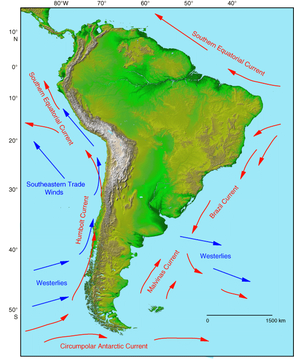
Hurricane Jed wrote:I saw something on the weather channel about that. The Peru current helps thwart development in that region because its a cold water current. There is also a Benguela current off the coast of southwest Africa that is also cold. Along the coast of Brazil there is a Brazil Current which is similar to the Gulf Stream in that it is warm but also significantly weaker than its North Atlantic counterpart.


Image

This graphic gives a good explanation
0 likes   

User avatar
HURAKAN
Professional-Met
Professional-Met
Posts: 46086
Age: 37
Joined: Thu May 20, 2004 4:34 pm
Location: Key West, FL
Contact:

#100 Postby HURAKAN » Tue Mar 15, 2011 11:48 am

Image

Looking good
0 likes   


Return to “2011”

Who is online

Users browsing this forum: No registered users and 95 guests