It is located at: 58N-1569E
Sorry I am not home so I am unable to put a photo up. It is on the NRL site though.
This one has a way to go to effect any land if it even does form into anything..it is SE of Guam.
Nothing on JTWC or JMA
WPAC: AERE (1101/03W/Bebeng) - Tropical Storm
Moderator: S2k Moderators
-
StormingB81

- S2K Supporter

- Posts: 5676
- Age: 42
- Joined: Thu Aug 27, 2009 1:45 am
- Location: Rockledge, Florida
WPAC: AERE (1101/03W/Bebeng) - Tropical Storm
Last edited by senorpepr on Sat May 07, 2011 3:25 am, edited 4 times in total.
Reason: JMA Upgrade to Aere
Reason: JMA Upgrade to Aere
0 likes
-
dexterlabio
- Category 5

- Posts: 3406
- Joined: Sat Oct 24, 2009 11:50 pm
Re: WPAC: Invest 93w

What do you think about this newly-formed invest?
0 likes
Personal Forecast Disclaimer:
The posts in this forum are NOT official forecast and should not be used as such. They are just the opinion of the poster and may or may not be backed by sound meteorological data. They are NOT endorsed by any professional institution or storm2k.org. For official information, please refer to the NHC and NWS products.
The posts in this forum are NOT official forecast and should not be used as such. They are just the opinion of the poster and may or may not be backed by sound meteorological data. They are NOT endorsed by any professional institution or storm2k.org. For official information, please refer to the NHC and NWS products.
-
dexterlabio
- Category 5
- Posts: 3406
- Joined: Sat Oct 24, 2009 11:50 pm
Re: WPAC: Invest 93w
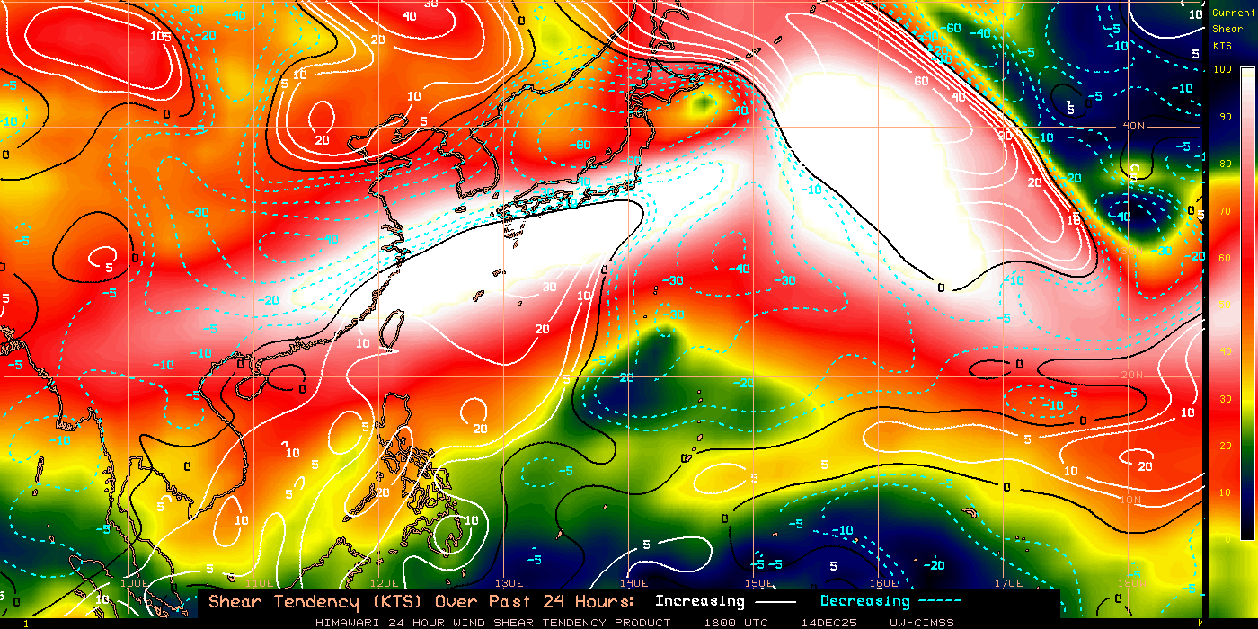
Recent shear tendency on the Western Pacific. I just want to post it anyway cause the previous invests were killed by the shear, and I think the chances of these invests to develop further rely on the condition of the shear in the ocean.
0 likes
Personal Forecast Disclaimer:
The posts in this forum are NOT official forecast and should not be used as such. They are just the opinion of the poster and may or may not be backed by sound meteorological data. They are NOT endorsed by any professional institution or storm2k.org. For official information, please refer to the NHC and NWS products.
The posts in this forum are NOT official forecast and should not be used as such. They are just the opinion of the poster and may or may not be backed by sound meteorological data. They are NOT endorsed by any professional institution or storm2k.org. For official information, please refer to the NHC and NWS products.
-
RobWESTPACWX
- WestPACMet

- Posts: 1616
- Joined: Fri Sep 17, 2010 2:26 am
- Location: Tokyo, Japan
- Contact:
Re: WPAC: Invest 93w
Agreed it does have a while to go, I did a video up on it today, also the large low over Japan later on but the first part is towards this invest.
[youtube]http://www.youtube.com/watch?v=MQy0ictrTPQ[/youtube]
On another note, these youtube videos are really taking off, kind of surprised at how well they are doing. If anyone is interested in learning on the program and maybe working on these as well for this coming season let me know.
[youtube]http://www.youtube.com/watch?v=MQy0ictrTPQ[/youtube]
On another note, these youtube videos are really taking off, kind of surprised at how well they are doing. If anyone is interested in learning on the program and maybe working on these as well for this coming season let me know.
0 likes
Satellites, Charts and Forecasting tools for East Asia at WESTERNPACIFICWEATHER.COM
-
RobWESTPACWX
- WestPACMet
- Posts: 1616
- Joined: Fri Sep 17, 2010 2:26 am
- Location: Tokyo, Japan
- Contact:
Re: WPAC: Invest 93w
NGPS taking a leap on this one now,

0 likes
Satellites, Charts and Forecasting tools for East Asia at WESTERNPACIFICWEATHER.COM
-
phwxenthusiast
- Category 2

- Posts: 637
- Joined: Wed Mar 24, 2010 3:10 am
- Location: Holbrook, NY (Long Island)
-
RobWESTPACWX
- WestPACMet
- Posts: 1616
- Joined: Fri Sep 17, 2010 2:26 am
- Location: Tokyo, Japan
- Contact:
Re: WPAC: Invest 93w
Not trying to spam this video so I'm just going to link it here, but I talk about 93W in it, my quick thoughts on it but ya the models are really picking up on it.
http://www.youtube.com/watch?v=vG2d8uPKCKI
http://www.youtube.com/watch?v=vG2d8uPKCKI
0 likes
Satellites, Charts and Forecasting tools for East Asia at WESTERNPACIFICWEATHER.COM
-
RobWESTPACWX
- WestPACMet
- Posts: 1616
- Joined: Fri Sep 17, 2010 2:26 am
- Location: Tokyo, Japan
- Contact:
Re: WPAC: Invest 93w
ECMWF piking up on something in the SCS in the 10th as well, not sure if they are related
http://www.ecmwf.int/products/forecasts ... 12!!!step/
http://www.ecmwf.int/products/forecasts ... 12!!!step/
0 likes
Satellites, Charts and Forecasting tools for East Asia at WESTERNPACIFICWEATHER.COM
-
dexterlabio
- Category 5
- Posts: 3406
- Joined: Sat Oct 24, 2009 11:50 pm
Re: WPAC: Invest 93w
Thanks Rob for the updates! Agree with you on that, shear seems to be tough for some cyclonic development on the area, unless if the shear would relax in the coming days.
At this point of the year, cyclones form in the SCS and track north or northeast. I think I would buy the euro models this time.
At this point of the year, cyclones form in the SCS and track north or northeast. I think I would buy the euro models this time.
0 likes
Personal Forecast Disclaimer:
The posts in this forum are NOT official forecast and should not be used as such. They are just the opinion of the poster and may or may not be backed by sound meteorological data. They are NOT endorsed by any professional institution or storm2k.org. For official information, please refer to the NHC and NWS products.
The posts in this forum are NOT official forecast and should not be used as such. They are just the opinion of the poster and may or may not be backed by sound meteorological data. They are NOT endorsed by any professional institution or storm2k.org. For official information, please refer to the NHC and NWS products.
-
Extratropical94

- Professional-Met

- Posts: 3535
- Age: 29
- Joined: Wed Oct 20, 2010 6:36 am
- Location: Hamburg, Germany
- Contact:

-
RobWESTPACWX
- WestPACMet
- Posts: 1616
- Joined: Fri Sep 17, 2010 2:26 am
- Location: Tokyo, Japan
- Contact:
Re: WPAC: Invest 93w
GFS and NGPS really going strong on this in the PI sea for the 8th and 9th.

0 likes
Satellites, Charts and Forecasting tools for East Asia at WESTERNPACIFICWEATHER.COM
-
dexterlabio
- Category 5
- Posts: 3406
- Joined: Sat Oct 24, 2009 11:50 pm
Re: WPAC: Invest 93w

Recent forecast models. Looks like this is going to affect the areas somewhere in Central Philippines, though I am not sure if it is indeed this invest picking up as shown in the models. I find the GFS track somewhat erroneous like it initialized the system far south.
0 likes
Personal Forecast Disclaimer:
The posts in this forum are NOT official forecast and should not be used as such. They are just the opinion of the poster and may or may not be backed by sound meteorological data. They are NOT endorsed by any professional institution or storm2k.org. For official information, please refer to the NHC and NWS products.
The posts in this forum are NOT official forecast and should not be used as such. They are just the opinion of the poster and may or may not be backed by sound meteorological data. They are NOT endorsed by any professional institution or storm2k.org. For official information, please refer to the NHC and NWS products.
-
RobWESTPACWX
- WestPACMet
- Posts: 1616
- Joined: Fri Sep 17, 2010 2:26 am
- Location: Tokyo, Japan
- Contact:
Re: WPAC: Invest 93w

If you want to swirl forecast then theirs a swing in the winds south of Guam, could be the start of something? Probably not, but something to watch.
0 likes
Satellites, Charts and Forecasting tools for East Asia at WESTERNPACIFICWEATHER.COM
-
dexterlabio
- Category 5
- Posts: 3406
- Joined: Sat Oct 24, 2009 11:50 pm
Re: WPAC: Invest 93w
ABPW10 PGTW 031400
MSGID/GENADMIN/NAVMARFCSTCEN PEARL HARBOR HI/JTWC//
SUBJ/SIGNIFICANT TROPICAL WEATHER ADVISORY FOR THE WESTERN AND
/SOUTH PACIFIC OCEANS REISSUED/031400Z-040600ZMAY2011//
RMKS/
1. WESTERN NORTH PACIFIC AREA (180 TO MALAY PENINSULA):
A. TROPICAL CYCLONE SUMMARY: NONE.
B. TROPICAL DISTURBANCE SUMMARY:
(1) AN AREA OF CONVECTION HAS PERSISTED NEAR 6.4N 133.7E,
APPROXIMATELY 80 NM SOUTHWEST OF PALAU. ANIMATED INFRARED SATELLITE
IMAGERY SHOWS A WEAK AND UNORGANIZED LOW LEVEL CIRCULATION CENTER
EMBEDDED WITHIN THE MONSOON TROUGH. DEEP CONVECTION IS MINIMAL AND
FLARING. UPPER LEVEL ANALYSIS INDICATES THE SYSTEM IS LOCATED JUST
EQUATORWARD OF THE RIDGE AXIS IN AN AREA OF LOW VERTICAL WIND SHEAR
AND DIVERGENCE ALOFT. SURFACE OBSERVATIONS FROM PALAU INDICATE 1009
MB. MAXIMUM SUSTAINED SURFACE WINDS ARE ESTIMATED AT 10 TO 15 KNOTS.
MINIMUM SEA LEVEL PRESSURE IS ESTIMATED TO BE NEAR 1007 MB. DUE TO
THE FAVORABLE UPPER LEVEL CONDITIONS AND HIGH SEA SURFACE
TEMPERATURES, THE POTENTIAL FOR THE DEVELOPMENT OF A SIGNIFICANT
TROPICAL CYCLONE WITHIN THE NEXT 24 HOURS IS POOR.
(2) NO OTHER SUSPECT AREAS.
2. SOUTH PACIFIC AREA (WEST COAST OF SOUTH AMERICA TO 135 EAST):
A. TROPICAL CYCLONE SUMMARY: NONE.
B. TROPICAL DISTURBANCE SUMMARY: NONE.
3. JUSTIFICATION FOR REISSUE: ADDED AREA IN PARA 1.B.(1) AS POOR. //
NNNN
0 likes
Personal Forecast Disclaimer:
The posts in this forum are NOT official forecast and should not be used as such. They are just the opinion of the poster and may or may not be backed by sound meteorological data. They are NOT endorsed by any professional institution or storm2k.org. For official information, please refer to the NHC and NWS products.
The posts in this forum are NOT official forecast and should not be used as such. They are just the opinion of the poster and may or may not be backed by sound meteorological data. They are NOT endorsed by any professional institution or storm2k.org. For official information, please refer to the NHC and NWS products.
-
Extratropical94
- Professional-Met
- Posts: 3535
- Age: 29
- Joined: Wed Oct 20, 2010 6:36 am
- Location: Hamburg, Germany
- Contact:
In the last paragraph of the JTWC outlook, why do they say that development chances are poor DUE TO favorable conditions?
Do they want to say that the conditions are bad because of favorable environment or do they want to express that they upgraded them to poor because of the good conditions?
Do they want to say that the conditions are bad because of favorable environment or do they want to express that they upgraded them to poor because of the good conditions?
0 likes
54° 11' 59'' N, 9° 9' 20'' E
Boomer Sooner!
Go Broncos! Go Cards! Go Niners!
- Daniel
Boomer Sooner!
Go Broncos! Go Cards! Go Niners!
- Daniel
-
RobWESTPACWX
- WestPACMet
- Posts: 1616
- Joined: Fri Sep 17, 2010 2:26 am
- Location: Tokyo, Japan
- Contact:
Re: WPAC: Invest 93w
ET, coming from someone that works with JT and these warnings I can agree with you on the confusion of the poor, fair and good system.
I'm sure this will be upgraded to fair soon though. But overall the level it is set at is based on the amount of atmospheric ingredients that are available at the current time. I.E Coriolis, shear, SST's. Not so much the model analysis.
With that said though they say it is upgraded to poor because it was nothing before. But conditions are still not prime. (I know confusing right?)
I'm sure we will see this upgraded here soon though.
0 likes
Satellites, Charts and Forecasting tools for East Asia at WESTERNPACIFICWEATHER.COM
-
RobWESTPACWX
- WestPACMet
- Posts: 1616
- Joined: Fri Sep 17, 2010 2:26 am
- Location: Tokyo, Japan
- Contact:
Re: WPAC: Invest 93w
Also I think NGPS is the MOC on this system, they seem to be producing it more ET vice a fully developed warm core low in the PI sea.

Also I want to mention Just south of Palua there really is a well organized circulation on this. We may see a TCFA out soon.
Also I want to mention Just south of Palua there really is a well organized circulation on this. We may see a TCFA out soon.
Last edited by RobWESTPACWX on Wed May 04, 2011 12:16 am, edited 1 time in total.
0 likes
Satellites, Charts and Forecasting tools for East Asia at WESTERNPACIFICWEATHER.COM
-
RobWESTPACWX
- WestPACMet
- Posts: 1616
- Joined: Fri Sep 17, 2010 2:26 am
- Location: Tokyo, Japan
- Contact:
Last thing I want to note, is as from someone from the West Pac, these storms are so not followed. Its rather funny. In the Atlantic an invest blew up and there was about 500 replies. Here, GFS is developing a full fledged system and no one is around! Wake up people!
0 likes
Satellites, Charts and Forecasting tools for East Asia at WESTERNPACIFICWEATHER.COM
-
phwxenthusiast
- Category 2
- Posts: 637
- Joined: Wed Mar 24, 2010 3:10 am
- Location: Holbrook, NY (Long Island)
Re:
Extratropical94 wrote:In the last paragraph of the JTWC outlook, why do they say that development chances are poor DUE TO favorable conditions?
Do they want to say that the conditions are bad because of favorable environment or do they want to express that they upgraded them to poor because of the good conditions?
is it because they're forecasting for the next 24 hours?? most models are not developing until late this week anyway so yeah i can i understand why they're giving a low chance of development currently...
RobWESTPACWX wrote:Last thing I want to note, is as from someone from the West Pac, these storms are so not followed. Its rather funny. In the Atlantic an invest blew up and there was about 500 replies. Here, GFS is developing a full fledged system and no one is around! Wake up people!
lol, oh they'll come! could be the 1st TS this season, what do you think??
0 likes

Re: WPAC: Invest 93w
I predict in the next 12 to 24 hours, we will see Tropical Storm Aere.
Aere is a Marshallese word meaning *storm*.
May God Bless All.
Aere is a Marshallese word meaning *storm*.
May God Bless All.
0 likes
Remember, all of my post aren't official. For official warnings and discussions, Please refer to your local NWS products...
NWS for the Western Pacific
https://www.weather.gov/gum/
NWS for the Western Pacific
https://www.weather.gov/gum/
Who is online
Users browsing this forum: No registered users and 24 guests