WPAC: SONGDA - Tropical Depression (1102/04W)
Moderator: S2k Moderators
-
climateconcern23
- Tropical Low

- Posts: 35
- Age: 33
- Joined: Sat Mar 05, 2011 4:38 am
- Location: Philippines
- Contact:
WPAC: SONGDA - Tropical Depression (1102/04W)
98w
Last edited by senorpepr on Mon May 30, 2011 4:27 am, edited 17 times in total.
Reason: Edited to change title to Tropical Storm
Reason: Edited to change title to Tropical Storm
0 likes
-
phwxenthusiast
- Category 2

- Posts: 637
- Joined: Wed Mar 24, 2010 3:10 am
- Location: Holbrook, NY (Long Island)
excuse me sir, but you have to follow the rules for creating a thread, especially the title...
anway, yes, there's a new invest out there: 98W

from NRLMRY...
btw, 00z Euro developing a TS at around 120 hour and moving westward, possibility towards the Philippines.... not sure though if this current Invest is the one Euro's hinting at...
anway, yes, there's a new invest out there: 98W
from NRLMRY...
btw, 00z Euro developing a TS at around 120 hour and moving westward, possibility towards the Philippines.... not sure though if this current Invest is the one Euro's hinting at...
0 likes
-
dexterlabio
- Category 5

- Posts: 3406
- Joined: Sat Oct 24, 2009 11:50 pm
Re: WPAC: INVEST 98W
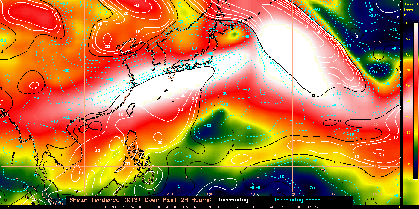
So I'm here again for the shear tendency. Hoho.
Yes, Euro shows something forming next week and tracking west to northwest towards Northern PI or Taiwan (?) but I don't think this is the invest euro is talking about.


Yes, Euro shows something forming next week and tracking west to northwest towards Northern PI or Taiwan (?) but I don't think this is the invest euro is talking about.
0 likes
Personal Forecast Disclaimer:
The posts in this forum are NOT official forecast and should not be used as such. They are just the opinion of the poster and may or may not be backed by sound meteorological data. They are NOT endorsed by any professional institution or storm2k.org. For official information, please refer to the NHC and NWS products.
The posts in this forum are NOT official forecast and should not be used as such. They are just the opinion of the poster and may or may not be backed by sound meteorological data. They are NOT endorsed by any professional institution or storm2k.org. For official information, please refer to the NHC and NWS products.
-
Typhoon_Willie

- Category 5
- Posts: 1042
- Joined: Mon Jun 09, 2003 3:19 pm
- Location: Greenacres City, Florida
-
RobWESTPACWX
- WestPACMet

- Posts: 1616
- Joined: Fri Sep 17, 2010 2:26 am
- Location: Tokyo, Japan
- Contact:
Re: WPAC: INVEST 98W
Looking semi organized this morning...

0 likes
Satellites, Charts and Forecasting tools for East Asia at WESTERNPACIFICWEATHER.COM
-
climateconcern23
- Tropical Low
- Posts: 35
- Age: 33
- Joined: Sat Mar 05, 2011 4:38 am
- Location: Philippines
- Contact:
Re: WPAC: INVEST 98W
Hi Mr. phwxenthusiast,
Thanks for reminding me about the rule. c:
climateconcern23
Thanks for reminding me about the rule. c:
climateconcern23
0 likes
-
climateconcern23
- Tropical Low
- Posts: 35
- Age: 33
- Joined: Sat Mar 05, 2011 4:38 am
- Location: Philippines
- Contact:
-
phwxenthusiast
- Category 2
- Posts: 637
- Joined: Wed Mar 24, 2010 3:10 am
- Location: Holbrook, NY (Long Island)
-
dexterlabio
- Category 5
- Posts: 3406
- Joined: Sat Oct 24, 2009 11:50 pm
Re: WPAC: INVEST 98W
There was slight change in the euro models, something will develop near Visayas and track WNW towards Bicol area. So we can see that models change from time to time so I think we should not focus on the long-range forecast tracks as for now.  They could be backing out on this later on, but definitely it would be good to observe and wait for the developments.
0 likes
Personal Forecast Disclaimer:
The posts in this forum are NOT official forecast and should not be used as such. They are just the opinion of the poster and may or may not be backed by sound meteorological data. They are NOT endorsed by any professional institution or storm2k.org. For official information, please refer to the NHC and NWS products.
The posts in this forum are NOT official forecast and should not be used as such. They are just the opinion of the poster and may or may not be backed by sound meteorological data. They are NOT endorsed by any professional institution or storm2k.org. For official information, please refer to the NHC and NWS products.
-
phwxenthusiast
- Category 2
- Posts: 637
- Joined: Wed Mar 24, 2010 3:10 am
- Location: Holbrook, NY (Long Island)
-
Extratropical94

- Professional-Met

- Posts: 3535
- Age: 29
- Joined: Wed Oct 20, 2010 6:36 am
- Location: Hamburg, Germany
- Contact:


-
phwxenthusiast
- Category 2
- Posts: 637
- Joined: Wed Mar 24, 2010 3:10 am
- Location: Holbrook, NY (Long Island)
-
cycloneye

- Admin

- Posts: 139046
- Age: 67
- Joined: Thu Oct 10, 2002 10:54 am
- Location: San Juan, Puerto Rico
Re: WPAC: INVEST 98W
It looks better than a few days ago.

0 likes
Visit the Caribbean-Central America Weather Thread where you can find at first post web cams,radars
and observations from Caribbean basin members Click Here
and observations from Caribbean basin members Click Here
-
oaba09
- S2K Supporter

- Posts: 1496
- Age: 37
- Joined: Thu Oct 01, 2009 10:02 am
- Location: Valenzuela, Philippines
- Contact:
Re: WPAC: INVEST 98W
dexterlabio wrote:There was slight change in the euro models, something will develop near Visayas and track WNW towards Bicol area. So we can see that models change from time to time so I think we should not focus on the long-range forecast tracks as for now.
This is the reason why I don't read into long range models too much....
0 likes
-
climateconcern23
- Tropical Low
- Posts: 35
- Age: 33
- Joined: Sat Mar 05, 2011 4:38 am
- Location: Philippines
- Contact:
-
cycloneye
- Admin
- Posts: 139046
- Age: 67
- Joined: Thu Oct 10, 2002 10:54 am
- Location: San Juan, Puerto Rico
Re: WPAC: INVEST 98W
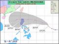
AN AREA OF CONVECTION HAS PERSISTED NEAR 7.7N 142.8E,
APPROXIMATELY 280 NM EAST-SOUTHEAST OF YAP. ANIMATED WATER VAPOR
IMAGERY SHOWS FORMATIVE, ALBEIT FRAGMENTED BANDING ALONG THE
SOUTHERN PERIPHERY OF THE LOW LEVEL CIRCULATION CENTER (LLCC). THE
SAME ANIMATION SHOWS GOOD POLEWARD OUTFLOW ENHANCED BY AN
ANTICYCLONIC POINT SOURCE DIRECTLY OVER THE LLCC. A 182016Z SSMI-S
MICROWAVE IMAGERY SHOWS A CURVED FEATURE WITH HIGH REFLECTIVITY
VALUES ALONG THE SOUTHERN RIM OF THE LLCC. RECENT SCATTEROMETRY DATA
OUTLINES A BROAD CIRCULATION WITH MAX WINDS NEAR THE CENTER. THIS
SUPPORTS MAXIMUM SUSTAINED SURFACE WIND ESTIMATES OF 10 TO 15 KNOTS.
MINIMUM SEA LEVEL PRESSURE IS ESTIMATED TO BE NEAR 1009 MB. DUE TO
THE FORMATIVE NATURE OF THE SYSTEM, THE POTENTIAL FOR THE
DEVELOPMENT OF A SIGNIFICANT TROPICAL CYCLONE WITHIN THE NEXT 24
HOURS IS POOR.
0 likes
Visit the Caribbean-Central America Weather Thread where you can find at first post web cams,radars
and observations from Caribbean basin members Click Here
and observations from Caribbean basin members Click Here
-
dexterlabio
- Category 5
- Posts: 3406
- Joined: Sat Oct 24, 2009 11:50 pm
Re: WPAC: INVEST 98W
So the euro shows a track almost similar to Aere.
0 likes
Personal Forecast Disclaimer:
The posts in this forum are NOT official forecast and should not be used as such. They are just the opinion of the poster and may or may not be backed by sound meteorological data. They are NOT endorsed by any professional institution or storm2k.org. For official information, please refer to the NHC and NWS products.
The posts in this forum are NOT official forecast and should not be used as such. They are just the opinion of the poster and may or may not be backed by sound meteorological data. They are NOT endorsed by any professional institution or storm2k.org. For official information, please refer to the NHC and NWS products.
-
ManilaTC

- WesternPacificWeather.com

- Posts: 592
- Age: 45
- Joined: Mon Oct 26, 2009 5:13 am
- Location: Mandaluyong City, Philippines
- Contact:
Re:
Extratropical94 wrote:GFS really picking up, moderate tropical storm on next Thursday.
Hey man, can you supply me with a link for this one? NCEP and GFS models?
0 likes
The above post is NOT official and should not be used as such. It is my opinion and may or may not be backed by sound meteorological data. It is not endorsed by any professional institution or storm2k.org. Please refer to your official national weather agency.
WEB http://goo.gl/JDiKXB | FB https://goo.gl/N5sIle | @ManilaTC
WEB http://goo.gl/JDiKXB | FB https://goo.gl/N5sIle | @ManilaTC
-
Extratropical94
- Professional-Met
- Posts: 3535
- Age: 29
- Joined: Wed Oct 20, 2010 6:36 am
- Location: Hamburg, Germany
- Contact:
No problem, try this page here:
http://moe.met.fsu.edu/cyclonephase/
http://moe.met.fsu.edu/cyclonephase/
0 likes
54° 11' 59'' N, 9° 9' 20'' E
Boomer Sooner!
Go Broncos! Go Cards! Go Niners!
- Daniel
Boomer Sooner!
Go Broncos! Go Cards! Go Niners!
- Daniel
-
RobWESTPACWX
- WestPACMet
- Posts: 1616
- Joined: Fri Sep 17, 2010 2:26 am
- Location: Tokyo, Japan
- Contact:
Re: WPAC: INVEST 98W
Agreed with GFS really picking up on this NGPS not so much, that was kind of the same way with the initiation for Aere, just FYI.

0 likes
Satellites, Charts and Forecasting tools for East Asia at WESTERNPACIFICWEATHER.COM
Who is online
Users browsing this forum: No registered users and 38 guests