ATL: INVEST 94L - DISCUSSION
Moderator: S2k Moderators


Amazed the NHC even bothered to make this 94L again, its only the shear that is pumping the convection up in the first place it seems
0 likes
Personal Forecast Disclaimer:
The posts in this forum are NOT official forecast and should not be used as such. They are just the opinion of the poster and may or may not be backed by sound meteorological data. They are NOT endorsed by any professional institution or storm2k.org. For official information, please refer to the NHC and NWS products
The posts in this forum are NOT official forecast and should not be used as such. They are just the opinion of the poster and may or may not be backed by sound meteorological data. They are NOT endorsed by any professional institution or storm2k.org. For official information, please refer to the NHC and NWS products

Re: ATL: INVEST 94L - DISCUSSION
PV anomaly is relatively low with max winds at the surface.
Temp anomaly is 1C and at a lower altitude than a typical symmetry warm core.
No boundary layer inversion, so with the heavy shear, MCS-type convection should continue to fire.
Classic Sub Trop system.


Temp anomaly is 1C and at a lower altitude than a typical symmetry warm core.
No boundary layer inversion, so with the heavy shear, MCS-type convection should continue to fire.
Classic Sub Trop system.
0 likes

Yeap, 94L looks like crap, the area of lowest pressure is fairly much naked again. The only thing I see it becoming is, like global models show, into a strong extratropical system in the NW Atlantic as the mid level energy keeps moving NE.
However, the moisture in the low levels keeps moving little by little into the general area of the FL Peninsula.
With the ULL in the eastern GOM it might be enough for widespread showers and storms to spread across the Peninsula this weekend, hopefully.

However, the moisture in the low levels keeps moving little by little into the general area of the FL Peninsula.
With the ULL in the eastern GOM it might be enough for widespread showers and storms to spread across the Peninsula this weekend, hopefully.
0 likes

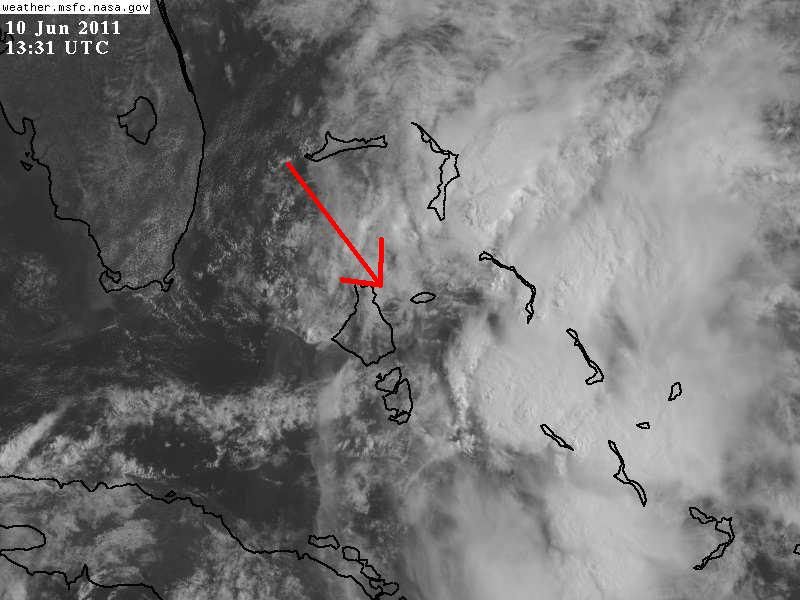
I had not noticed the surface pressure at Nassau this morning, which is down to 1010 mb, down 5 mb in 24 hrs, much lower than the sourounding areas. I thought that lowest surface pressures were still south of Cuba.
And looking at the first vis sat loop, there appears to be a surface vorticity near that Island or northern Andros Island. Just an area of interest at this point, most likely it will happen the same thing in which a LLC is trying to develop here but eventually it will get sheared away with the surface vorticity get left behind and the mid level energy keep moving to the NE.
And looking at the first vis sat loop, there appears to be a surface vorticity near that Island or northern Andros Island. Just an area of interest at this point, most likely it will happen the same thing in which a LLC is trying to develop here but eventually it will get sheared away with the surface vorticity get left behind and the mid level energy keep moving to the NE.
0 likes

-
SouthDadeFish

- Professional-Met

- Posts: 2835
- Joined: Thu Sep 23, 2010 2:54 pm
- Location: Miami, FL
- Contact:

Re:
NDG wrote:I had not noticed the surface pressure at Nassau this morning, which is down to 1010 mb, down 5 mb in 24 hrs, much lower than the sourounding areas. I thought that lowest surface pressures were still south of Cuba.
And looking at the first vis sat loop, there appears to be a surface vorticity near that Island or northern Andros Island. Just an area of interest at this point, most likely it will happen the same thing in which a LLC is trying to develop here but eventually it will get sheared away with the surface vorticity get left behind and the mid level energy keep moving to the NE.
Yeah I also saw see the rotation in the lower cloud field on the first visible pics this morning right over Nassau. Ihe next TWO should point out this area in more detail. IMHO
0 likes
The following post is NOT an official forecast and should not be used as such. It is just the opinion of the poster and may or may not be backed by sound meteorological data. It is NOT endorsed by any professional institution including storm2k.org For Official Information please refer to the NHC and NWS products.
-
Blown Away

- S2K Supporter

- Posts: 9861
- Joined: Wed May 26, 2004 6:17 am
Re: ATL: INVEST 94L - DISCUSSION
All that rain is so close but yet so far!! My plants and grass are screaming!!
0 likes
Hurricane Eye Experience: David 79, Irene 99, Frances 04, Jeanne 04, Wilma 05...
Hurricane Brush Experience: Andrew 92, Erin 95, Floyd 99, Matthew 16, Irma 17, Ian 22, Nicole 22…
Hurricane Brush Experience: Andrew 92, Erin 95, Floyd 99, Matthew 16, Irma 17, Ian 22, Nicole 22…
Surface conditions at Nassau Int'l airport agrees with sat indicated LLC just to its west, reporting SSE wind, pressure steady at 1010 mb, still 5 mb lower than 24 hrs ago.
Funny thing that surface plots do not show surface pressures anywhere close to 1010mb.
Funny thing that surface plots do not show surface pressures anywhere close to 1010mb.
Code: Select all
METAR text:  MYNN 101400Z 15007KT 9999 -RA BKN012 BKN015TCU OVC120 27/26 A2984
Conditions at:  MYNN (NASSAU INTL , BS) observed 1400 UTC 10 June 2011
Temperature:  27.0°C (81°F)
Dewpoint:  26.0°C (79°F) [RH = 94%]
Pressure (altimeter):  29.84 inches Hg (1010.6 mb)
Winds:  from the SSE (150 degrees) at 8 MPH (7 knots; 3.6 m/s)
Visibility:  6 or more miles (10+ km)
Ceiling:  1200 feet AGL
Clouds:  broken clouds at 1200 feet AGL
broken clouds at 1500 feet AGL
overcast cloud deck at 12000 feet AGL
Weather:  -RA  (light rain)
0 likes
Re:
SouthDadeFish wrote:This thing would have a chance if it wasn't under 60 knots of shear....
Actually, Nassau's 12z sounding shows 40-50 knots of shear between H30 & H20, not that is much better. The LLC will have to get moving quick to the NE if it wants to keep up with convection, mid level SW shear is around 15-20 knots, pushing the convection NE.
0 likes

-
SouthFloridawx

- S2K Supporter
- Posts: 8344
- Age: 45
- Joined: Tue Jul 26, 2005 1:16 am
- Location: Sarasota, FL
- Contact:


Who is online
Users browsing this forum: No registered users and 60 guests