WPAC: NOCK-TEN (Juaning) - Tropical Depression
Moderator: S2k Moderators
Still calm here in Manila..
0 likes
The above post is not official and should not be used as such. It is the opinion of the poster and may or may not be backed by sound meteorological data. It is not endorsed by any professional institution or storm2k.org. For official information, please refer to the NHC and NWS products.


Re: WPAC: NOCK-TEN - Tropical Storm
ClarkEligue wrote:Hey pro mets, Is it undergoing an RI?
I'm not a pro, but that presentation sure is suggestive of some quick strengthening occuring. I suspect the jog away from land has helped to get the systems inflow going again and thus leading to strengthening...
The rain is still the biggest area of concern though IMO.
0 likes
Personal Forecast Disclaimer:
The posts in this forum are NOT official forecast and should not be used as such. They are just the opinion of the poster and may or may not be backed by sound meteorological data. They are NOT endorsed by any professional institution or storm2k.org. For official information, please refer to the NHC and NWS products
The posts in this forum are NOT official forecast and should not be used as such. They are just the opinion of the poster and may or may not be backed by sound meteorological data. They are NOT endorsed by any professional institution or storm2k.org. For official information, please refer to the NHC and NWS products
-
ManilaTC

- WesternPacificWeather.com

- Posts: 592
- Age: 45
- Joined: Mon Oct 26, 2009 5:13 am
- Location: Mandaluyong City, Philippines
- Contact:
Re: WPAC: NOCK-TEN - Tropical Storm
Going to sleep now, tomorrow we face Juaning/Nock-ten.
0 likes
The above post is NOT official and should not be used as such. It is my opinion and may or may not be backed by sound meteorological data. It is not endorsed by any professional institution or storm2k.org. Please refer to your official national weather agency.
WEB http://goo.gl/JDiKXB | FB https://goo.gl/N5sIle | @ManilaTC
WEB http://goo.gl/JDiKXB | FB https://goo.gl/N5sIle | @ManilaTC

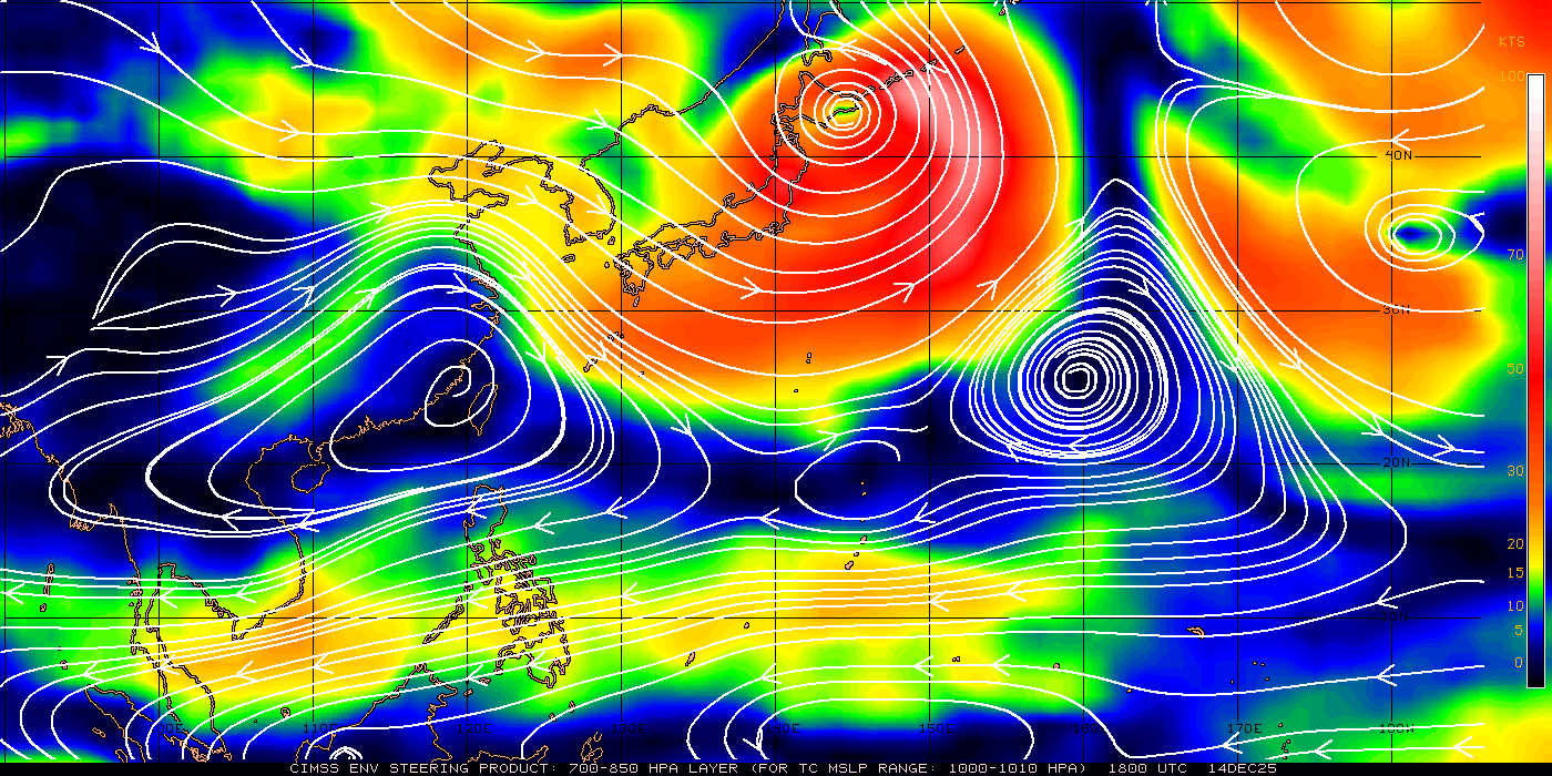
Thats superb picture Hurakan, look at how far its dragging air in from the south and west!
0 likes
Personal Forecast Disclaimer:
The posts in this forum are NOT official forecast and should not be used as such. They are just the opinion of the poster and may or may not be backed by sound meteorological data. They are NOT endorsed by any professional institution or storm2k.org. For official information, please refer to the NHC and NWS products
The posts in this forum are NOT official forecast and should not be used as such. They are just the opinion of the poster and may or may not be backed by sound meteorological data. They are NOT endorsed by any professional institution or storm2k.org. For official information, please refer to the NHC and NWS products
-
phwxenthusiast
- Category 2

- Posts: 637
- Joined: Wed Mar 24, 2010 3:10 am
- Location: Holbrook, NY (Long Island)
Re:
Typhoon Hunter wrote:JTWC might as well not bother warning on this storm - forecasts lack any consistency and totally behind the curve so to speak. One reason I rant about this is because vast majority of the media as well as websites such as Wunderground and Tropical Storm Risk mirror their data.
Looks like Nockten is really ramping up and to my eye that does looks like some kind of proto-eyewall trying to form. Great to see PAGASA really engaging this one in a positive way.
Stay safe all our friends in Philippines, storms like this have a record of being quite deadly!
haha, i couldn't agree more James...! seems to me "they were just not there" throughout this storm... indeed, PAGASA is doing a good job on Juaning, could be better but still okay for me...
0 likes

Very impressive southern quadrant, northern quadrant isn't quite as good mind you, but clearly the JWTC are a little on the low side with thier estimates.
0 likes
Personal Forecast Disclaimer:
The posts in this forum are NOT official forecast and should not be used as such. They are just the opinion of the poster and may or may not be backed by sound meteorological data. They are NOT endorsed by any professional institution or storm2k.org. For official information, please refer to the NHC and NWS products
The posts in this forum are NOT official forecast and should not be used as such. They are just the opinion of the poster and may or may not be backed by sound meteorological data. They are NOT endorsed by any professional institution or storm2k.org. For official information, please refer to the NHC and NWS products
-
HURAKAN

- Professional-Met

- Posts: 46086
- Age: 37
- Joined: Thu May 20, 2004 4:34 pm
- Location: Key West, FL
- Contact:
ZCZC 616
WTPQ20 RJTD 261500
RSMC TROPICAL CYCLONE ADVISORY
NAME TS 1108 NOCK-TEN (1108)
ANALYSIS
PSTN 261500UTC 14.6N 122.9E FAIR
MOVE WNW 06KT
PRES 990HPA
MXWD 045KT
GUST 065KT
30KT 150NM
FORECAST
24HF 271500UTC 16.8N 119.7E 75NM 70%
MOVE WNW 11KT
PRES 992HPA
MXWD 040KT
GUST 060KT
45HF 281200UTC 18.3N 116.1E 140NM 70%
MOVE WNW 11KT
PRES 985HPA
MXWD 050KT
GUST 070KT
69HF 291200UTC 19.2N 112.6E 160NM 70%
MOVE WNW 09KT
PRES 980HPA
MXWD 055KT
GUST 080KT =
NNNN
0 likes

-
phwxenthusiast
- Category 2
- Posts: 637
- Joined: Wed Mar 24, 2010 3:10 am
- Location: Holbrook, NY (Long Island)

-
HURAKAN
- Professional-Met
- Posts: 46086
- Age: 37
- Joined: Thu May 20, 2004 4:34 pm
- Location: Key West, FL
- Contact:

WTPN31 PGTW 262100
MSGID/GENADMIN/NAVMARFCSTCEN PEARL HARBOR HI/JTWC//
SUBJ/TROPICAL CYCLONE WARNING//
RMKS/
1. TROPICAL STORM 10W (NOCK-TEN) WARNING NR 009
02 ACTIVE TROPICAL CYCLONES IN NORTHWESTPAC
MAX SUSTAINED WINDS BASED ON ONE-MINUTE AVERAGE
WIND RADII VALID OVER OPEN WATER ONLY
---
WARNING POSITION:
261800Z --- NEAR 14.9N 122.6E
MOVEMENT PAST SIX HOURS - 310 DEGREES AT 06 KTS
POSITION ACCURATE TO WITHIN 060 NM
POSITION BASED ON CENTER LOCATED BY SATELLITE
PRESENT WIND DISTRIBUTION:
MAX SUSTAINED WINDS - 055 KT, GUSTS 070 KT
WIND RADII VALID OVER OPEN WATER ONLY
RADIUS OF 050 KT WINDS - 020 NM NORTHEAST QUADRANT
020 NM SOUTHEAST QUADRANT
020 NM SOUTHWEST QUADRANT
020 NM NORTHWEST QUADRANT
RADIUS OF 034 KT WINDS - 070 NM NORTHEAST QUADRANT
050 NM SOUTHEAST QUADRANT
050 NM SOUTHWEST QUADRANT
060 NM NORTHWEST QUADRANT
REPEAT POSIT: 14.9N 122.6E
---
FORECASTS:
12 HRS, VALID AT:
270600Z --- 16.1N 120.8E
MAX SUSTAINED WINDS - 050 KT, GUSTS 065 KT
WIND RADII VALID OVER OPEN WATER ONLY
VECTOR TO 24 HR POSIT: 295 DEG/ 14 KTS
---
24 HRS, VALID AT:
271800Z --- 17.2N 118.2E
MAX SUSTAINED WINDS - 050 KT, GUSTS 065 KT
WIND RADII VALID OVER OPEN WATER ONLY
RADIUS OF 034 KT WINDS - 065 NM NORTHEAST QUADRANT
050 NM SOUTHEAST QUADRANT
050 NM SOUTHWEST QUADRANT
060 NM NORTHWEST QUADRANT
VECTOR TO 36 HR POSIT: 290 DEG/ 14 KTS
---
36 HRS, VALID AT:
280600Z --- 18.2N 115.4E
MAX SUSTAINED WINDS - 055 KT, GUSTS 070 KT
WIND RADII VALID OVER OPEN WATER ONLY
RADIUS OF 050 KT WINDS - 025 NM NORTHEAST QUADRANT
025 NM SOUTHEAST QUADRANT
025 NM SOUTHWEST QUADRANT
025 NM NORTHWEST QUADRANT
RADIUS OF 034 KT WINDS - 080 NM NORTHEAST QUADRANT
065 NM SOUTHEAST QUADRANT
070 NM SOUTHWEST QUADRANT
075 NM NORTHWEST QUADRANT
VECTOR TO 48 HR POSIT: 290 DEG/ 11 KTS
---
EXTENDED OUTLOOK:
48 HRS, VALID AT:
281800Z --- 19.0N 113.2E
MAX SUSTAINED WINDS - 060 KT, GUSTS 075 KT
WIND RADII VALID OVER OPEN WATER ONLY
RADIUS OF 050 KT WINDS - 030 NM NORTHEAST QUADRANT
030 NM SOUTHEAST QUADRANT
030 NM SOUTHWEST QUADRANT
030 NM NORTHWEST QUADRANT
RADIUS OF 034 KT WINDS - 090 NM NORTHEAST QUADRANT
080 NM SOUTHEAST QUADRANT
085 NM SOUTHWEST QUADRANT
090 NM NORTHWEST QUADRANT
VECTOR TO 72 HR POSIT: 285 DEG/ 07 KTS
---
72 HRS, VALID AT:
291800Z --- 19.7N 110.2E
MAX SUSTAINED WINDS - 050 KT, GUSTS 065 KT
WIND RADII VALID OVER OPEN WATER ONLY
VECTOR TO 96 HR POSIT: 270 DEG/ 07 KTS
---
LONG RANGE OUTLOOK:
NOTE...ERRORS FOR TRACK HAVE AVERAGED NEAR 250 NM
ON DAY 4 AND 350 NM ON DAY 5... AND FOR INTENSITY
NEAR 20 KT EACH DAY.
---
96 HRS, VALID AT:
301800Z --- 19.7N 107.4E
MAX SUSTAINED WINDS - 045 KT, GUSTS 055 KT
WIND RADII VALID OVER OPEN WATER ONLY
VECTOR TO 120 HR POSIT: 275 DEG/ 11 KTS
---
120 HRS, VALID AT:
311800Z --- 20.1N 102.9E
MAX SUSTAINED WINDS - 020 KT, GUSTS 030 KT
WIND RADII VALID OVER OPEN WATER ONLY
DISSIPATING AS A SIGNIFICANT TROPICAL CYCLONE OVER LAND
---
REMARKS:
262100Z POSITION NEAR 15.2N 122.2E.
TROPICAL STORM 10W (NOCK-TEN), LOCATED APPROXIMATELY 1100 NM EAST OF
MANILA, PHILIPPINES, HAS TRACKED NORTHWESTWARD AT 06 KNOTS OVER THE
PAST SIX HOURS. RECENT ANIMATED INFRARED IMAGERY SHOWS CONVECTION
HAS DEEPENED WITH COOLING CLOUD TOPS AND A FORMATIVE BANDING EYE
FEATURE STARTING TO DEVELOP. A 261744z AMSR-E IMAGE SHOWS A DEEP
CONVECTIVE BAND WRAPPING MOSTLY AROUND A BANDING MICROWAVE EYE
FEATURE WITH FRAGMENTS OF MORE BANDING FORMING TO THE SOUTH AND THE
NORTH OF THE LOW LEVEL CIRCULATION CENTER (LLCC). UPPER-LEVEL
ANALYSIS HAS THE SYSTEM BENEATH AN ANTICYCLONE PROVIDING FAIR RADIAL
OUTFLOW, WITH ENHANCED OUTFLOW INTO THE TROPICAL EASTERLY JET (TEJ)
TO THE SOUTHWEST. VENTING IS STARTING TO LINK INTO A TROPICAL UPPER-
TROPOSPHERIC TROUGH (TUTT) TO THE NORTHEAST. THE SYSTEM IS CURRENTLY
STEERING ALONG THE SOUTHERN PERIPHERY OF THE SUBTROPICAL RIDGE
EXTENDING FROM SOUTHERN CHINA EASTWARD TO THE RYUKYU ISLANDS. TS 10W
WILL MAKE LANDFALL ON LUZON IN THE NEXT 12 HOURS AND WILL START TO
LOSE INTENSITY BEFORE MOVING BACK OVER THE SOUTH CHINA SEA. OUTFLOW
TO THE TUTT WILL BE LOST BY THAT TIME, BUT THE TEJ WILL CONTINUE TO
PROVIDE EQUATORWARD OUTFLOW AND THE SYSTEM IS EXPECTED TO SLOWLY
INTENSIFY BEFORE MAKING LANDFALL FOR A SECOND TIME OVER HAINAN
BEFORE MOVING INTO THE GULF OF TONKIN AND FINALLY VIETNAM. MODEL
GUIDANCE IS IN TIGHT AGREEMENT; THEREFORE THIS FORECAST IS CLOSE TO
THE MODEL CONSENSUS. NEXT WARNINGS AT 270300Z, 270900Z, 271500Z AND
272100Z. REFER TO TROPICAL DEPRESSION 11W (ELEVEN) WARNINGS (WTPN32
PGTW) FOR SIX-HOURLY UPDATES.//
NNNN
0 likes
Well 55kts is much more like it, sounds about right to me. Suspect we'll see this become a typhoon in the end providing it doesn't get torn to pieces by land.
Taking its time to make landfall as well.
Taking its time to make landfall as well.
0 likes
Personal Forecast Disclaimer:
The posts in this forum are NOT official forecast and should not be used as such. They are just the opinion of the poster and may or may not be backed by sound meteorological data. They are NOT endorsed by any professional institution or storm2k.org. For official information, please refer to the NHC and NWS products
The posts in this forum are NOT official forecast and should not be used as such. They are just the opinion of the poster and may or may not be backed by sound meteorological data. They are NOT endorsed by any professional institution or storm2k.org. For official information, please refer to the NHC and NWS products
-
ManilaTC
- WesternPacificWeather.com
- Posts: 592
- Age: 45
- Joined: Mon Oct 26, 2009 5:13 am
- Location: Mandaluyong City, Philippines
- Contact:
Re: WPAC: NOCK-TEN - Tropical Storm
Very wobbly movement, attempting to form a huge eye...
0 likes
The above post is NOT official and should not be used as such. It is my opinion and may or may not be backed by sound meteorological data. It is not endorsed by any professional institution or storm2k.org. Please refer to your official national weather agency.
WEB http://goo.gl/JDiKXB | FB https://goo.gl/N5sIle | @ManilaTC
WEB http://goo.gl/JDiKXB | FB https://goo.gl/N5sIle | @ManilaTC
-
oaba09
- S2K Supporter

- Posts: 1496
- Age: 37
- Joined: Thu Oct 01, 2009 10:02 am
- Location: Valenzuela, Philippines
- Contact:
I decided to skip work as a preventive measure...Our house is in a flood prone area so I decided to not take a risk...
Last edited by oaba09 on Tue Jul 26, 2011 6:47 pm, edited 1 time in total.
0 likes


-
dhoeze
- Tropical Storm

- Posts: 130
- Age: 42
- Joined: Tue Oct 27, 2009 2:32 am
- Location: Manila, Philippines
Re:
oaba09 wrote:I decided to skip work as a preventive measure...Our house is in a flood prone area so I decided to not take a risk...
Be careful there my fellow flip.
0 likes
"Productivity is never an accident. It is always the result of a commitment to excellence, intelligent planning, and focused effort."
-
Extratropical94

- Professional-Met
- Posts: 3535
- Age: 29
- Joined: Wed Oct 20, 2010 6:36 am
- Location: Hamburg, Germany
- Contact:
Nock-ten is now officially a STS.
<Analyses at 27/00 UTC>
Scale -
Intensity -
Center position N15°35'(15.6°)
E122°20'(122.3°)
Direction and speed of movement NW 10km/h(6kt)
Central pressure 985hPa
Maximum wind speed near the center 25m/s(50kt)
Maximum wind gust speed 35m/s(70kt)
Area of 30kt winds or more Wide 300km(160NM)
<Analyses at 27/00 UTC>
Scale -
Intensity -
Center position N15°35'(15.6°)
E122°20'(122.3°)
Direction and speed of movement NW 10km/h(6kt)
Central pressure 985hPa
Maximum wind speed near the center 25m/s(50kt)
Maximum wind gust speed 35m/s(70kt)
Area of 30kt winds or more Wide 300km(160NM)
0 likes
54° 11' 59'' N, 9° 9' 20'' E
Boomer Sooner!
Go Broncos! Go Cards! Go Niners!
- Daniel
Boomer Sooner!
Go Broncos! Go Cards! Go Niners!
- Daniel
Who is online
Users browsing this forum: No registered users and 34 guests