
ATL: Ex INVEST 92L - Discussion
Moderator: S2k Moderators
-
SouthDadeFish

- Professional-Met

- Posts: 2835
- Joined: Thu Sep 23, 2010 2:54 pm
- Location: Miami, FL
- Contact:
-
Ivanhater

- Storm2k Moderator

- Posts: 10852
- Age: 37
- Joined: Fri Jul 01, 2005 8:25 am
- Location: Pensacola
Re: ATL: INVEST 92L - Discussion
50 percent
A SHARP TROUGH OF LOW PRESSURE LOCATED ABOUT 1000 MILES EAST OF
THE NORTHERN LEEWARD ISLANDS IS MOVING WEST-NORTHWESTWARD AT NEAR
20 MPH. ALTHOUGH THUNDERSTORM ACTIVITY HAS BECOME A LITTLE BETTER
ORGANIZED...THERE ARE NO SIGNS OF A SURFACE CIRCULATION AT THIS
TIME. ENVIRONMENTAL CONDITIONS ARE FORECAST TO GRADUALLY BECOME
MORE CONDUCIVE FOR DEVELOPMENT...AND THIS SYSTEM HAS A MEDIUM
CHANCE...50 PERCENT...OF BECOMING A TROPICAL CYCLONE DURING THE
NEXT 48 HOURS.
0 likes
Michael
-
northjaxpro

- S2K Supporter

- Posts: 8900
- Joined: Mon Sep 27, 2010 11:21 am
- Location: Jacksonville, FL
It appears that 92L is approaching 94L rather quickly from the southeast. I have to wonder pretty soon that some interaction with these two systems may occur.
0 likes
NEVER, EVER SAY NEVER in the tropics and weather in general, and most importantly, with life itself!!
________________________________________________________________________________________
Fay 2008 Beryl 2012 Debby 2012 Colin 2016 Hermine 2016 Julia 2016 Matthew 2016 Irma 2017 Dorian 2019
________________________________________________________________________________________
Fay 2008 Beryl 2012 Debby 2012 Colin 2016 Hermine 2016 Julia 2016 Matthew 2016 Irma 2017 Dorian 2019
-
cycloneye

- Admin

- Posts: 139075
- Age: 67
- Joined: Thu Oct 10, 2002 10:54 am
- Location: San Juan, Puerto Rico
Re: ATL: INVEST 92L - Discussion
18z Best Track for 92L
AL, 92, 2011081218, , BEST, 0, 186N, 469W, 30, 1011, DB
AL, 92, 2011081218, , BEST, 0, 186N, 469W, 30, 1011, DB
0 likes
Visit the Caribbean-Central America Weather Thread where you can find at first post web cams,radars
and observations from Caribbean basin members Click Here
and observations from Caribbean basin members Click Here


2. A SHARP TROUGH OF LOW PRESSURE LOCATED ABOUT 1000 MILES EAST OF
THE NORTHERN LEEWARD ISLANDS IS MOVING WEST-NORTHWESTWARD AT NEAR
20 MPH. ALTHOUGH THUNDERSTORM ACTIVITY HAS BECOME A LITTLE BETTER
ORGANIZED...THERE ARE NO SIGNS OF A SURFACE CIRCULATION AT THIS
TIME. ENVIRONMENTAL CONDITIONS ARE FORECAST TO GRADUALLY BECOME
MORE CONDUCIVE FOR DEVELOPMENT...AND THIS SYSTEM HAS A MEDIUM
CHANCE...50 PERCENT...OF BECOMING A TROPICAL CYCLONE DURING THE
NEXT 48 HOURS.
0 likes
_____________________
There can be only one Hypercane.....

There can be only one Hypercane.....


Re: ATL: INVEST 92L - Discussion
I know this is off topic, but what happened to 95L
0 likes
Once I see the REDS and GREENS Converge on a Base Velocity. ... I'm There!!
This is NOT an Official Forecast....Just my Opinion. For official information, please refer to the NHC and NWS products.
HIGHLIGHTS : '13 El Reno Tornado : 2013 Storm Chaser Tour, Joaquin; SC flood event, Matthew '16, Lowcountry Snow storm Jan '18
This is NOT an Official Forecast....Just my Opinion. For official information, please refer to the NHC and NWS products.
HIGHLIGHTS : '13 El Reno Tornado : 2013 Storm Chaser Tour, Joaquin; SC flood event, Matthew '16, Lowcountry Snow storm Jan '18
Re: ATL: INVEST 92L - Discussion
Kohlecane wrote:I know this is off topic, but what happened to 95L
Woops spoke to soon Welcome 6
0 likes
Once I see the REDS and GREENS Converge on a Base Velocity. ... I'm There!!
This is NOT an Official Forecast....Just my Opinion. For official information, please refer to the NHC and NWS products.
HIGHLIGHTS : '13 El Reno Tornado : 2013 Storm Chaser Tour, Joaquin; SC flood event, Matthew '16, Lowcountry Snow storm Jan '18
This is NOT an Official Forecast....Just my Opinion. For official information, please refer to the NHC and NWS products.
HIGHLIGHTS : '13 El Reno Tornado : 2013 Storm Chaser Tour, Joaquin; SC flood event, Matthew '16, Lowcountry Snow storm Jan '18
-
MGC

- S2K Supporter
- Posts: 5792
- Joined: Sun Mar 23, 2003 9:05 pm
- Location: Pass Christian MS, or what is left.
Re: ATL: INVEST 92L - Discussion
92L looks to be developing a pretty good circulation. It might be TD 7 soon.....MGC
0 likes
-
Florida1118
- Category 5

- Posts: 1805
- Age: 27
- Joined: Sat Jun 19, 2010 12:57 pm
- Location: Tampa, Florida
Re: ATL: INVEST 92L - Discussion
MGC wrote:92L looks to be developing a pretty good circulation. It might be TD 7 soon.....MGC
I think 94L will recieve #7...but looks like 92L gets #8 and 93L #9. Im confident these will all develop. We may challenge last years 19...
Personal Forecast Disclaimer:
The posts in this forum are NOT official forecast and should not be used as such. They are just the opinion of the poster and may or may not be backed by sound meteorological data. They are NOT endorsed by any professional institution or storm2k.org. For official information, please refer to the NHC and NWS products.
0 likes
-
ozonepete
- Professional-Met
- Posts: 4743
- Joined: Mon Sep 07, 2009 3:23 pm
- Location: From Ozone Park, NYC / Now in Brooklyn, NY
Re: ATL: INVEST 92L - Discussion
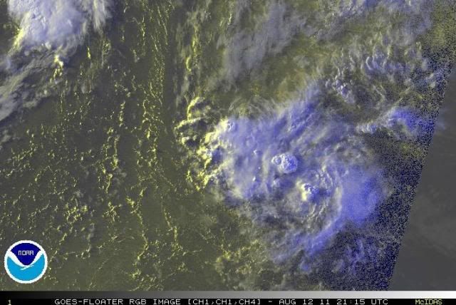
I think 92L is next at bat - will get TD 7, although it's a close race with 94L. Look at those 2 hot towers that just exploded. There's clearly an LLC now and the big tower towards the bottom right is blowing up right over it.
0 likes
-
leanne_uk
- Tropical Storm

- Posts: 214
- Age: 41
- Joined: Fri Sep 04, 2009 4:38 pm
- Location: Loughborough countryside, Leicestershire, UK
Re: ATL: INVEST 92L - Discussion
you can see it starting to wrap itself up.
I cant believe the past 24 hours, starting to get busy it seems.
Lovely pic
0 likes
-
StarmanHDB

- Tropical Storm
- Posts: 201
- Age: 59
- Joined: Wed Sep 02, 2009 7:59 pm
- Location: West Palm Beach, Florida
Re: ATL: INVEST 92L - Discussion
Beautiful hot towers! I'm seeing "Franklin" in his infancy.
0 likes
-
cycloneye
- Admin
- Posts: 139075
- Age: 67
- Joined: Thu Oct 10, 2002 10:54 am
- Location: San Juan, Puerto Rico
Re: ATL: INVEST 92L - Discussion
40%
A TROUGH OF LOW PRESSURE LOCATED ABOUT 1000 MILES EAST OF THE
NORTHERN LEEWARD ISLANDS IS MOVING WEST-NORTHWESTWARD AT NEAR
20 MPH. THERE ARE NO SIGNS OF A SURFACE CIRCULATION AT THIS TIME...
AND UPPER-LEVEL WINDS HAVE BECOME LESS FAVORABLE FOR DEVELOPMENT
DURING THE PAST SEVERAL HOURS. THERE REMAINS THE POTENTIAL FOR
SLOW DEVELOPMENT OF THIS SYSTEM...AND IT HAS A MEDIUM CHANCE...
40 PERCENT...OF BECOMING A TROPICAL CYCLONE DURING THE NEXT 48
HOURS.
0 likes
Visit the Caribbean-Central America Weather Thread where you can find at first post web cams,radars
and observations from Caribbean basin members Click Here
and observations from Caribbean basin members Click Here
-
SouthDadeFish
- Professional-Met
- Posts: 2835
- Joined: Thu Sep 23, 2010 2:54 pm
- Location: Miami, FL
- Contact:
-
StarmanHDB
- Tropical Storm
- Posts: 201
- Age: 59
- Joined: Wed Sep 02, 2009 7:59 pm
- Location: West Palm Beach, Florida
Re: ATL: INVEST 92L - Discussion
cycloneye wrote:40%
A TROUGH OF LOW PRESSURE LOCATED ABOUT 1000 MILES EAST OF THE
NORTHERN LEEWARD ISLANDS IS MOVING WEST-NORTHWESTWARD AT NEAR
20 MPH. THERE ARE NO SIGNS OF A SURFACE CIRCULATION AT THIS TIME...
AND UPPER-LEVEL WINDS HAVE BECOME LESS FAVORABLE FOR DEVELOPMENT
DURING THE PAST SEVERAL HOURS. THERE REMAINS THE POTENTIAL FOR
SLOW DEVELOPMENT OF THIS SYSTEM...AND IT HAS A MEDIUM CHANCE...
40 PERCENT...OF BECOMING A TROPICAL CYCLONE DURING THE NEXT 48
HOURS.
Yet another example of how looks can be deceiving?
0 likes

Re: ATL: INVEST 92L - Discussion
Interesting that 92L really got creamed after that anomaly occurred.

0 likes
-
cycloneye
- Admin
- Posts: 139075
- Age: 67
- Joined: Thu Oct 10, 2002 10:54 am
- Location: San Juan, Puerto Rico
Re: ATL: INVEST 92L - Discussion
30%
A WELL-DEFINED TROUGH OF LOW PRESSURE LOCATED ABOUT 600 MILES
EAST-NORTHEAST OF THE NORTHERN LEEWARD ISLANDS IS PRODUCING A
SMALL AREA OF SCATTERED SHOWERS AND THUNDERSTORMS. THIS SYSTEM
IS SHOWING SOME SIGNS OF ORGANIZATION THIS MORNING...BUT
ENVIRONMENTAL CONDITIONS ARE ONLY EXPECTED TO BE MARGINALLY
FAVORABLE FOR DEVELOPMENT DURING THE NEXT COUPLE OF DAYS. THIS
SYSTEM HAS A MEDIUM CHANCE...30 PERCENT...OF BECOMING A TROPICAL
CYCLONE DURING THE NEXT 48 HOURS AS IT MOVES WEST-NORTHWESTWARD
AT AROUND 20 MPH.
0 likes
Visit the Caribbean-Central America Weather Thread where you can find at first post web cams,radars
and observations from Caribbean basin members Click Here
and observations from Caribbean basin members Click Here
-
Extratropical94

- Professional-Met
- Posts: 3535
- Age: 29
- Joined: Wed Oct 20, 2010 6:36 am
- Location: Hamburg, Germany
- Contact:
Up to 40%
A WELL-DEFINED TROUGH OF LOW PRESSURE LOCATED ABOUT 525 MILES
NORTHEAST OF THE NORTHERN LEEWARD ISLANDS IS PRODUCING SCATTERED
SHOWERS AND THUNDERSTORMS. THIS DISTURBANCE IS GRADUALLY SHOWING
SIGNS OF ORGANIZATION...AND ENVIRONMENTAL CONDITIONS ARE EXPECTED
TO BECOME MORE CONDUCIVE FOR DEVELOPMENT DURING THE NEXT COUPLE OF
DAYS. THIS SYSTEM HAS A MEDIUM CHANCE...40 PERCENT...OF BECOMING
A TROPICAL CYCLONE DURING THE NEXT 48 HOURS AS IT MOVES
WEST-NORTHWESTWARD AT 15 TO 20 MPH.
0 likes
54° 11' 59'' N, 9° 9' 20'' E
Boomer Sooner!
Go Broncos! Go Cards! Go Niners!
- Daniel
Boomer Sooner!
Go Broncos! Go Cards! Go Niners!
- Daniel
-
Extratropical94
- Professional-Met
- Posts: 3535
- Age: 29
- Joined: Wed Oct 20, 2010 6:36 am
- Location: Hamburg, Germany
- Contact:
-
Aric Dunn
- Category 5
- Posts: 21228
- Age: 41
- Joined: Sun Sep 19, 2004 9:58 pm
- Location: Ready for the Chase.
- Contact:
going to go out on a limb here and say 92L wont ever develop... lol
0 likes
Note: If I make a post that is brief. Please refer back to previous posts for the analysis or reasoning. I do not re-write/qoute what my initial post said each time.
If there is nothing before... then just ask
Space & Atmospheric Physicist, Embry-Riddle Aeronautical University,
I believe the sky is falling...
If there is nothing before... then just ask
Space & Atmospheric Physicist, Embry-Riddle Aeronautical University,
I believe the sky is falling...
Who is online
Users browsing this forum: No registered users and 110 guests