Well then, four in a row...
BEGIN
NHC_ATCF
invest_al952011.invest
FSTDA
R
U
040
010
0000
201108121229
NONE
NOTIFY=ATRP
END
INVEST, AL, L, , , , , 95, 2011, DB, O, 2011081212, 9999999999, , , , , , METWATCH, , AL952011
AL, 95, 2011081112, , BEST, 0, 304N, 740W, 20, 1014, DB, 0, , 0, 0, 0, 0, 1014, 200, 60, 0, 0,
AL, 95, 2011081118, , BEST, 0, 314N, 724W, 25, 1011, DB, 0, , 0, 0, 0, 0, 1014, 200, 60, 0, 0,
AL, 95, 2011081200, , BEST, 0, 325N, 706W, 25, 1011, DB, 0, , 0, 0, 0, 0, 1014, 200, 40, 0, 0,
AL, 95, 2011081206, , BEST, 0, 336N, 688W, 25, 1011, DB, 0, , 0, 0, 0, 0, 1014, 200, 40, 0, 0,
AL, 95, 2011081212, , BEST, 0, 348N, 668W, 25, 1011, DB, 34, NEQ, 0, 0, 0, 0, 1014, 200, 40, 0, 0, L, 0, , 0, 0, INVEST, S,
And the TWO for 95L (as it is posted in the Talkin Tropics thread for this system):
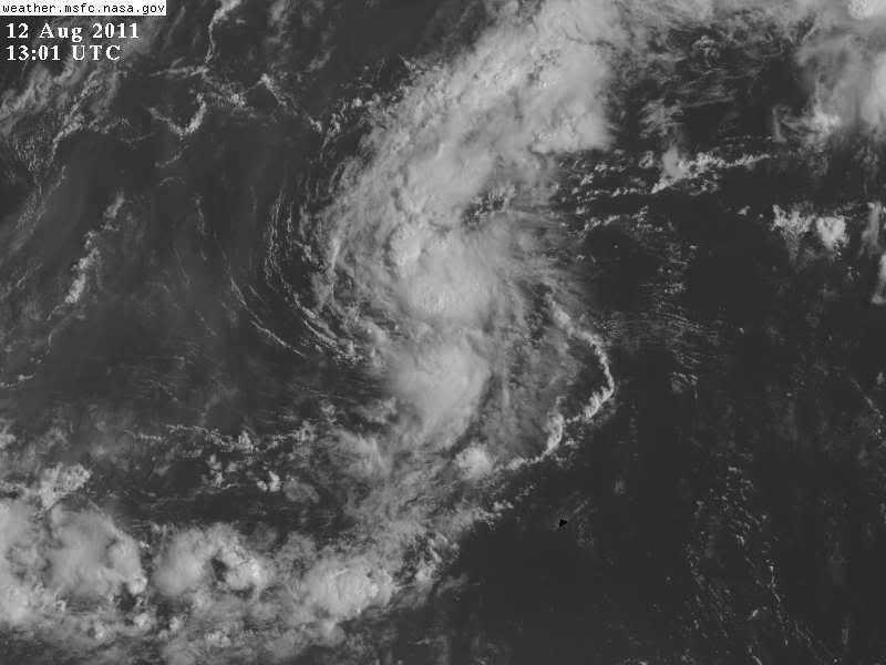
3. SHOWER ACTIVITY ASSOCIATED WITH A WEAK LOW PRESSURE SYSTEM LOCATED
ABOUT 160 MILES WEST-NORTHWEST OF BERMUDA HAS CONTINUED TO BECOME A
LITTLE BETTER ORGANIZED. SOME ADDITIONAL DEVELOPMENT IS POSSIBLE
DURING THE NEXT DAY OR SO BEFORE THIS DISTURBANCE MERGES WITH A
FRONTAL SYSTEM. THIS SYSTEM HAS A MEDIUM CHANCE...30 PERCENT...OF
BECOMING A TROPICAL CYCLONE DURING THE NEXT 48 HOURS AS IT MOVES
NORTHEASTWARD AT 15 TO 20 MPH.
Link to the TT thread:
viewtopic.php?f=31&t=111433
ATL: FRANKLIN - Remnants - Discussion
Moderator: S2k Moderators
-
Extratropical94

- Professional-Met

- Posts: 3535
- Age: 29
- Joined: Wed Oct 20, 2010 6:36 am
- Location: Hamburg, Germany
- Contact:
ATL: FRANKLIN - Remnants - Discussion
Last edited by Extratropical94 on Sat Aug 13, 2011 1:22 pm, edited 4 times in total.
0 likes
54° 11' 59'' N, 9° 9' 20'' E
Boomer Sooner!
Go Broncos! Go Cards! Go Niners!
- Daniel
Boomer Sooner!
Go Broncos! Go Cards! Go Niners!
- Daniel
-
Extratropical94
- Professional-Met
- Posts: 3535
- Age: 29
- Joined: Wed Oct 20, 2010 6:36 am
- Location: Hamburg, Germany
- Contact:
ATL: FRANKLIN - Models
Last edited by Extratropical94 on Sat Aug 13, 2011 4:54 am, edited 3 times in total.
0 likes
54° 11' 59'' N, 9° 9' 20'' E
Boomer Sooner!
Go Broncos! Go Cards! Go Niners!
- Daniel
Boomer Sooner!
Go Broncos! Go Cards! Go Niners!
- Daniel
-
cycloneye

- Admin

- Posts: 139008
- Age: 67
- Joined: Thu Oct 10, 2002 10:54 am
- Location: San Juan, Puerto Rico
Re: ATL: INVEST 95L - Models
Code: Select all
WHXX01 KWBC 121230
CHGHUR
TROPICAL CYCLONE GUIDANCE MESSAGE
NWS NATIONAL HURRICANE CENTER MIAMI FL
1230 UTC FRI AUG 12 2011

DISCLAIMER...NUMERICAL MODELS ARE SUBJECT TO LARGE ERRORS.
PLEASE REFER TO NHC OFFICIAL FORECASTS FOR TROPICAL CYCLONE
AND SUBTROPICAL CYCLONE INFORMATION.

ATLANTIC OBJECTIVE AIDS FOR

DISTURBANCE INVEST (AL952011) 20110812 1200 UTC

        ...00 HRS...   ...12 HRS...   ...24 HRS. ..   ...36 HRS...
        110812  1200   110813  0000   110813  1200   110814  0000

         LAT    LON     LAT    LON     LAT    LON     LAT    LON
BAMS    34.8N  66.8W   35.8N  64.0W   36.7N  61.9W   37.5N  60.2W
BAMD    34.8N  66.8W   37.1N  62.5W   39.7N  57.8W   42.2N  51.0W
BAMM    34.8N  66.8W   36.6N  63.3W   38.4N  60.0W   40.0N  56.1W
LBAR    34.8N  66.8W   37.1N  63.0W   40.4N  58.8W   43.8N  53.2W
SHIP        25KTS          31KTS          37KTS          43KTS
DSHP        25KTS          31KTS          37KTS          43KTS

        ...48 HRS...   ...72 HRS...   ...96 HRS. ..   ..120 HRS...
        110814  1200   110815  1200   110816  1200   110817  1200

         LAT    LON     LAT    LON     LAT    LON     LAT    LON
BAMS    38.4N  58.6W   39.7N  54.0W   40.7N  49.8W   42.6N  45.3W
BAMD    43.4N  42.5W   44.5N  25.9W   46.7N   8.0W   48.6N   8.5E
BAMM    41.1N  51.8W   42.1N  43.7W   40.9N  38.3W   39.3N  37.2W
LBAR    46.2N  45.1W     .0N    .0W     .0N    .0W     .0N    .0W
SHIP        44KTS          34KTS          21KTS           0KTS
DSHP        44KTS          34KTS          21KTS           0KTS

         ...INITIAL CONDITIONS...
LATCUR =  34.8N LONCUR =  66.8W DIRCUR =  55DEG SPDCUR =  19KT
LATM12 =  32.5N LONM12 =  70.6W DIRM12 =  53DEG SPDM12 =  19KT
LATM24 =  30.4N LONM24 =  74.0W
WNDCUR =   25KT RMAXWD =   40NM WNDM12 =   25KT
CENPRS = 1011MB OUTPRS = 1014MB OUTRAD =  200NM SDEPTH =   S
RD34NE =    0NM RD34SE =    0NM RD34SW =    0NM RD34NW =   0NM
0 likes
Visit the Caribbean-Central America Weather Thread where you can find at first post web cams,radars
and observations from Caribbean basin members Click Here
and observations from Caribbean basin members Click Here


-
brunota2003

- S2K Supporter

- Posts: 9476
- Age: 33
- Joined: Sat Jul 30, 2005 9:56 pm
- Location: Stanton, KY...formerly Havelock, NC
- Contact:
-
cycloneye
- Admin
- Posts: 139008
- Age: 67
- Joined: Thu Oct 10, 2002 10:54 am
- Location: San Juan, Puerto Rico
Re: ATL: INVEST 95L - Discussion
12z Best Track for 95L
AL, 95, 2011081212, , BEST, 0, 348N, 668W, 25, 1011, DB
ftp://ftp.tpc.ncep.noaa.gov/atcf/tcweb/ ... 011.invest
AL, 95, 2011081212, , BEST, 0, 348N, 668W, 25, 1011, DB
ftp://ftp.tpc.ncep.noaa.gov/atcf/tcweb/ ... 011.invest
0 likes
Visit the Caribbean-Central America Weather Thread where you can find at first post web cams,radars
and observations from Caribbean basin members Click Here
and observations from Caribbean basin members Click Here

Re: ATL: INVEST 95L - Discussion
0 likes
-
cycloneye
- Admin
- Posts: 139008
- Age: 67
- Joined: Thu Oct 10, 2002 10:54 am
- Location: San Juan, Puerto Rico
Re: ATL: INVEST 95L - Discussion
Macrocane wrote::eek: 4 invests, someone turned the swith on. Let's see how many of them become named storms.
Interesting question for a poll at TT.
0 likes
Visit the Caribbean-Central America Weather Thread where you can find at first post web cams,radars
and observations from Caribbean basin members Click Here
and observations from Caribbean basin members Click Here


Re: ATL: INVEST 95L - Discussion
Looked what popped up! Two new ones. Interesting days ahead for storm watching.
0 likes
-
floridasun78
- Category 5

- Posts: 3755
- Joined: Sun May 17, 2009 10:16 pm
- Location: miami fl
-
cycloneye
- Admin
- Posts: 139008
- Age: 67
- Joined: Thu Oct 10, 2002 10:54 am
- Location: San Juan, Puerto Rico
Re: ATL: INVEST 95L - Discussion
cycloneye wrote:Macrocane wrote::eek: 4 invests, someone turned the swith on. Let's see how many of them become named storms.
Interesting question for a poll at TT.
I made a thread at Talking Tropics forum about which of the invests will be named storms.
0 likes
Visit the Caribbean-Central America Weather Thread where you can find at first post web cams,radars
and observations from Caribbean basin members Click Here
and observations from Caribbean basin members Click Here
-
WilmingtonSandbar
- S2K Supporter
- Posts: 503
- Joined: Sun Aug 29, 2010 12:11 pm
- Location: Southport, NC
Re: ATL: INVEST 95L - Discussion
94l picked up some of Emily's moisture, but the main vorticity went northeast, so in my opinion it is a new system.
0 likes

-
SouthDadeFish

- Professional-Met
- Posts: 2835
- Joined: Thu Sep 23, 2010 2:54 pm
- Location: Miami, FL
- Contact:

-
OuterBanker
- S2K Supporter
- Posts: 1704
- Joined: Wed Feb 26, 2003 10:53 am
- Location: Nags Head, NC
- Contact:
-
cycloneye
- Admin
- Posts: 139008
- Age: 67
- Joined: Thu Oct 10, 2002 10:54 am
- Location: San Juan, Puerto Rico
Re:
OuterBanker wrote:Seems storms that get named become fish. This one has the best structure of all of them. It will add to the name list and bother no one.
You are right.Is now with a code red at 60%.
0 likes
Visit the Caribbean-Central America Weather Thread where you can find at first post web cams,radars
and observations from Caribbean basin members Click Here
and observations from Caribbean basin members Click Here
-
Ivanhater

- Storm2k Moderator

- Posts: 10852
- Age: 37
- Joined: Fri Jul 01, 2005 8:25 am
- Location: Pensacola
Re: ATL: INVEST 95L - Discussion
60 percent
THUNDERSTORM ACTIVITY ASSOCIATED WITH A WELL-DEFINED LOW PRESSURE
SYSTEM LOCATED ABOUT 200 MILES NORTH OF BERMUDA HAS BECOME MUCH
BETTER ORGANIZED DURING THE PAST SEVERAL HOURS. ADDITIONAL
DEVELOPMENT IS POSSIBLE TONIGHT OR TUESDAY BEFORE THIS DISTURBANCE
MERGES WITH A FRONTAL SYSTEM. THIS SYSTEM HAS A HIGH CHANCE...60
PERCENT...OF BECOMING A TROPICAL OR SUBTROPICAL CYCLONE DURING THE
NEXT 48 HOURS AS IT MOVES NORTHEASTWARD AT 20 TO 25 MPH.
0 likes
Michael
Who is online
Users browsing this forum: No registered users and 22 guests