 - God bless the victims!
ATL: IRENE - Remnants - Discussion
Moderator: S2k Moderators
-
CrazyC83
- Professional-Met

- Posts: 33393
- Joined: Tue Mar 07, 2006 11:57 pm
- Location: Deep South, for the first time!
Re: ATL: IRENE - Tropical Storm - Discussion
Goodnight Irene...probably forever. She's likely headed for the - God bless the victims!
- God bless the victims!
0 likes
-
wsquared77
- S2K Supporter

- Posts: 186
- Age: 47
- Joined: Mon Aug 30, 2004 6:50 pm
- Location: New Bern NC
- Contact:
Re: ATL: IRENE - Remnants - Discussion
Finally have power back and checking in from New Bern NC. LOTS of water and LOTS of downed trees but doing OK around here. Thought I'd share a picture: Looking across the street to our neighbor's house...there are normally 5 steps up to his porch.

Uploaded with ImageShack.us

Uploaded with ImageShack.us
0 likes
-
tomboudreau

- Category 5

- Posts: 1869
- Age: 47
- Joined: Tue Feb 18, 2003 6:07 pm
- Location: Carnegie, PA
- Contact:
Re: ATL: IRENE - Remnants - Discussion
Anyone else catch this in the final discussion from the Hurricane Center on Irene. I don't recall every seeing them put this paragraph on a discussion before at the end of it.
Pretty cool they gave a big thanks to all those that helped with monitoring and putting valuable information into the forecast of this storm.
Code: Select all
THE NATIONAL HURRICANE CENTER WOULD LIKE TO THANK THE AIR FORCE
RESERVE AND NOAA HURRICANE HUNTERS FOR ALL THE RECONNAISSANCE AND
SURVEILLANCE DATA COLLECTED DURING IRENE...AS WELL AS ALL THE LOCAL
WEATHER SERVICE OFFICES THAT CONDUCTED SPECIAL RADIOSONDE RELEASES
DURING THE PAST WEEK.
Pretty cool they gave a big thanks to all those that helped with monitoring and putting valuable information into the forecast of this storm.
0 likes
They've actually been pretty gracious in the past about thanking everyone from the Hurricane Hunters as they continued to fly through Katrina as the storm approached their home base in Biloxi to the government of Cuba for allowing civilian research flights into Cuban airspace in assorted discussions.
0 likes
-
CrazyC83
- Professional-Met
- Posts: 33393
- Joined: Tue Mar 07, 2006 11:57 pm
- Location: Deep South, for the first time!
Re: ATL: IRENE - Remnants - Discussion
tomboudreau wrote:Anyone else catch this in the final discussion from the Hurricane Center on Irene. I don't recall every seeing them put this paragraph on a discussion before at the end of it.Code: Select all
THE NATIONAL HURRICANE CENTER WOULD LIKE TO THANK THE AIR FORCE
RESERVE AND NOAA HURRICANE HUNTERS FOR ALL THE RECONNAISSANCE AND
SURVEILLANCE DATA COLLECTED DURING IRENE...AS WELL AS ALL THE LOCAL
WEATHER SERVICE OFFICES THAT CONDUCTED SPECIAL RADIOSONDE RELEASES
DURING THE PAST WEEK.
Pretty cool they gave a big thanks to all those that helped with monitoring and putting valuable information into the forecast of this storm.
That was so sweet for writing that
0 likes

The NHC (and, indeed, the CPHC) has made it a point in the past to thank hurricane hunters on most major systems threatening the US (including HI).
The NHC's remit is pretty clear, that is to warn on tropical cyclones. Post-tropical cyclones are no longer within their jurisdiction and it's more than fair to hand it off to a different agency, especially when there are other tropical threats developing. The Canadian HC handles post-tropical cyclones well enough anyway.
CrazyC83 wrote:I do think NHC should continue advisories on post-tropical storms over or threatening land with at least 35 kt sustained winds though. HPC should only handle them if under 35 kt.
The NHC's remit is pretty clear, that is to warn on tropical cyclones. Post-tropical cyclones are no longer within their jurisdiction and it's more than fair to hand it off to a different agency, especially when there are other tropical threats developing. The Canadian HC handles post-tropical cyclones well enough anyway.
0 likes
-
Hurricane Jed

- Category 2

- Posts: 542
- Age: 36
- Joined: Mon Jan 24, 2011 3:36 pm
- Location: Cen Tex
From the Canadian Hurricane Centre:
WOCN31 CWHX 290245
INTERMEDIATE TROPICAL CYCLONE INFORMATION STATEMENT ISSUED BY THE
CANADIAN HURRICANE CENTRE OF ENVIRONMENT CANADA AT 12:05 AM ADT
MONDAY 29 AUGUST 2011.
---------------------------------------------------------------------
INTERMEDIATE TROPICAL CYCLONE INFORMATION STATEMENT FOR:
=NEW= ATLANTIC PROVINCES
=NEW= SOUTHERN QUEBEC.
FOR POST-TROPICAL STORM IRENE.
THE NEXT STATEMENT WILL BE ISSUED BY 3:00 AM ADT.
CENTER OF POST-TROPICAL STORM IRENE NEAR THE CANADIAN BORDER.
HEAVY RAIN AND STRONG WINDS AFFECTING SOUTHERN QUEBEC AND THE
MARITIMES.
---------------------------------------------------------------------
==DISCUSSION==
1. SUMMARY OF BASIC INFORMATION AT 12.00 AM ADT.
LOCATION: 45.3 NORTH 71.3 WEST.
ABOUT 10 KILOMETRES EAST OF SHERBROOKE, QUEBEC.
MAXIMUM SUSTAINED WINDS: 95 KM/H.
PRESENT MOVEMENT: NORTH NORTHEAST AT 43 KM/H.
MINIMUM CENTRAL PRESSURE: 980 MB.
TROPICAL STORM WARNINGS REMAIN IN EFFECT FOR THE FUNDY COASTLINES OF
NEW BRUNSWICK AND NOVA SCOTIA AS WELL AS THE ATLANTIC COAST OF NOVA
SCOTIA SOUTHWEST OF PORTER'S LAKE. RAINFALL WARNINGS ARE IN
EFFECT FOR MOST OF NEW BRUNSWICK AND PARTS OF EASTERN AND SOUTHERN
QUEBEC. WIND WARNINGS ARE IN EFFECT FOR MOST OF THE MARITIMES.
SOME NOTABLE WIND GUSTS AS OF 11 PM ADT:
YARMOUTH, NS............................93 KM/H
WINDY HILL (NEAR GREENWOOD), NS)....... 80 KM/H
LAC ST. PIERRE, QC......................83 KM/H
POINTE DE L ISLET, QC...................80 KM/H
SOME NOTABLE RAINFALL TOTALS AS OF 9 PM ADT:
DOAKDOWN, NB (FROM CANWARN)............87.5 MM
FREDERICTON, NB........................71.0 MM
CAMPABELLO ISLAND, NB(FROM CANWARN)....71.0 MM
ST. STEPHEN, NB........................60.8 MM
MECHANIC SETTLEMENT, NB................53.6 MM
SHEREBROOKE, QC...........102.0 MM
ST. CLOTHIDE, QC...........81.3 MM
NICOLET, QC................62.0 MM
SOME NOTABLE SEA STATES AS OF 11 PM ADT.
BUOY 44024 (BROWNS BANK MARINE AREA.....6.3 METRES
BUOY 44037 (NEAR LURCHER MARINE AREA....7.0 METRES
THE NEXT FULL INFORMATION STATEMENT ON IRENE WILL BE ISSUED BY 3:00
AM ADT.
VISIT WEATHEROFFICE.GC.CA/HURRICANE (ALL IN LOWER CASE) FOR THE
LATEST:
- FORECAST POSITION, CENTRAL PRESSURE TABLE.
- STRENGTH AND PREDICTED WIND RADII TABLE.
- HURRICANE TRACK INFORMATION MAP.
- TECHNICAL DISCUSSION.
PLEASE ALSO REFER TO THE PUBLIC AND MARINE FORECASTS AND WARNINGS
ISSUED BY ENVIRONMENT CANADA FOR YOUR AREA.
END
0 likes
-
Category 5

- Category 5
- Posts: 10074
- Age: 34
- Joined: Sun Feb 11, 2007 10:00 pm
- Location: New Brunswick, NJ
- Contact:
Re: ATL: IRENE - Remnants - Discussion
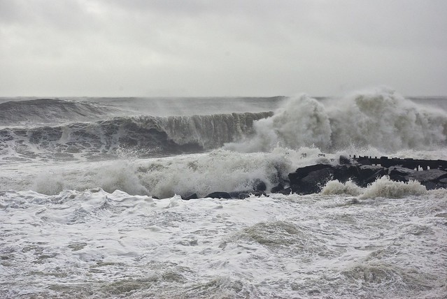
I took this earlier this morning in Long Branch shortly after the center of Irene buzzed by us.
0 likes

"GAME SET MATCH GIANTS WILL WIN THE NFC EAST and have a FIRST ROUND BYE with a win next week!!!" - StormingB81, the Giants lost, and did not win the NFC east.
-
GoneBabyGone
- Tropical Storm

- Posts: 101
- Joined: Sat Aug 30, 2008 4:28 pm
Re: ATL: IRENE - Remnants - Discussion
My town (Monroe Township) is basically an island right now. Tried for 5 hours earlier to find an open road to get home. No luck.
http://i.imgur.com/tRTOw.jpg - about 10 minutes from my house
http://msnbcmedia.msn.com/j/MSNBC/Compo ... id-8x2.jpg - from about 25 minutes north.
http://i.imgur.com/tRTOw.jpg - about 10 minutes from my house
http://msnbcmedia.msn.com/j/MSNBC/Compo ... id-8x2.jpg - from about 25 minutes north.
0 likes

Re: ATL: IRENE - Remnants - Discussion
I've been watching the news about the damages and some places (especially Vermont) have been hit hard, it's impressive to see those floods, it kind of reminds me to the floods that produced Hurricane Stan in Mexico and Central America. I think that Irene is like a modern Agnes that has proved to people in US that a cat 1 is dangerous. Hope that everyone affected recovers rapidly.
0 likes

Re:
If I had a penny every time "We dodged a bullet" was mentioned by someone, I could buy an island. No one dodged anything with Irene (Big size), it was a historic and devastating hurricane for many people and 21 in the US got hit with a "bullet". If this went out to sea, what would it be called then? The thing that bothers me the most is no matter what happens, I hear "we dodged a bullet" every single time in every single hurricane that hits the US or anywhere near there. Even the worst hurricanes have all had the line thrown at it, it's incredible. Katrina, Wilma, Andrew, Ivan, Charley, you name it. Will there be a day the line is not stated at all? I doubt it  .
.
^^^
Above are my thoughts for the general public and is not targeted at any one individual. Please don't take this as an abrasive toned message.
Well if this scenario had played out, then Hurricane Irene would have grazed the tip of Nantucket and hit Canada as a weak CAT1 hurricane most likely (carrying out your "Dodged a bullet" comment). To hit New England has a CAT3 in this set up I think a strong CAT5 where it was on Thursday morning would have been necessary.
.^^^
Above are my thoughts for the general public and is not targeted at any one individual. Please don't take this as an abrasive toned message.
Hurricane Jed wrote:If it had sped up and not hit North Carolina and had maintained strong Cat 1, 2 or weak 3 intensity things would have been much worse.
Well if this scenario had played out, then Hurricane Irene would have grazed the tip of Nantucket and hit Canada as a weak CAT1 hurricane most likely (carrying out your "Dodged a bullet" comment). To hit New England has a CAT3 in this set up I think a strong CAT5 where it was on Thursday morning would have been necessary.
0 likes
-
tropicana

- Category 5
- Posts: 8056
- Joined: Sat Sep 27, 2003 6:48 pm
- Location: Niagara Falls, Ontario, Canada
- Contact:
Re: ATL: IRENE - Advisories
Tropical cyclone information statement corrected by the Canadian
Hurricane Centre of Environment Canada
At 8:48 AM ADT Monday 29 August 2011
---------------------------------------------------------------------
Tropical cyclone information statement for:
Atlantic provinces
Southern Quebec. The next statement will be issued by 3:00 PM ADT.
Irene now moving northeastward through Southern Quebec.
---------------------------------------------------------------------
Summary of basic information at 9.00 AM ADT.
Location: 48.6 north 67.9 west.
About 55 kilometres ( 35 miles) south-southeast of Baie Comeau, QC (Baie Comeau is a town approx 260 miles NE of QUebec City QC, on the shores of the Saint Lawrence River.
Maximum sustained winds: 95 km/h ( 50mph).
Present movement: northeast at 45 km/h ( 28mph).
Minimum central pressure: 985 MB.
Rainfall warnings are still in effect for portions of Southern
Quebec. Wind warnings are still in effect for mainland Nova Scotia,
all but Northwestern New Brunswick, Prince Edward Island and portions
of Southern Quebec.
Irene's extensive wind field is still affecting the Maritimes and
Southern Quebec this morning with strong and gusty winds. Parts of
Southern New Brunswick, northern and mainland Nova Scotia and Prince
Edward Island continue to experience wind gusts near 90 km/h.
Strong winds will also affect much of the Northern Gulf of St.
Lawrence today. Very strong northeasterly winds continue to affect
portions of the St. Lawrence River Valley. Île d'Orleans, Qc in the
St. Lawrence river reported a wind gust of 113 km/h and ile aux grues
reported a gust of 104 km/h.
The heaviest rain from post-tropical Irene is now confined to the
northern half of the St. Lawrence River Valley where rainfall.
Warnings remain in effect. Parts of Labrador are expected to receive
between 20 and 40 millimetres of rain later today. Much of
Southeastern Quebec and Western New Brunswick received between 50 to
over 100 millimeters of rain.
Heavy seas, pounding surf and higher than normal water levels are
expected along the Fundy coast of New Brunswick during today's high
tide around midday. Heavy surf and elevated water levels are also
expected later today in the Northern Gulf of St. Lawrence.
Gale or storm force wind warnings are in effect for most of the
Maritimes marine district. Gale and storm force wind warnings are in
effect for areas of the St. Lawrence River Valley. Gale warnings are
also in effect for Western Newfoundland marine waters as well. Wave
heights of near 6 metres are occurring over western maritime waters
this morning. Large waves up to 5 metres could occur over portions
of the Northern Gulf of St. Lawrence later today.
0 likes
-
CrazyC83
- Professional-Met
- Posts: 33393
- Joined: Tue Mar 07, 2006 11:57 pm
- Location: Deep South, for the first time!
Re: Re:
Cyclenall wrote:If I had a penny every time "We dodged a bullet" was mentioned by someone, I could buy an island. No one dodged anything with Irene (Big size), it was a historic and devastating hurricane for many people and 21 in the US got hit with a "bullet". If this went out to sea, what would it be called then? The thing that bothers me the most is no matter what happens, I hear "we dodged a bullet" every single time in every single hurricane that hits the US or anywhere near there. Even the worst hurricanes have all had the line thrown at it, it's incredible. Katrina, Wilma, Andrew, Ivan, Charley, you name it. Will there be a day the line is not stated at all? I doubt it
^^^
Above are my thoughts for the general public and is not targeted at any one individual. Please don't take this as an abrasive toned message.Hurricane Jed wrote:If it had sped up and not hit North Carolina and had maintained strong Cat 1, 2 or weak 3 intensity things would have been much worse.
Well if this scenario had played out, then Hurricane Irene would have grazed the tip of Nantucket and hit Canada as a weak CAT1 hurricane most likely (carrying out your "Dodged a bullet" comment). To hit New England has a CAT3 in this set up I think a strong CAT5 where it was on Thursday morning would have been necessary.
Very few storms are legit Cat 3s at that latitude, and they have special circumstances requiring such. Since 1851, I believe only TWO storms hit the US coast north of North Carolina as a Cat 3: Carol and the 1938 hurricane. (I believe Edna was a Cat 2, the 1944 storm was no higher than a Cat 2, Donna was a Cat 1 and Gloria a Cat 1 at landfalls.) The 1869 storm I cannot really comment as I don't know the specifics.
Carol made it there mainly because it was a fairly small storm (for Northeast standards) and quite tight, able to tap the Gulf Stream (think Juan in 2003 farther southwest). The 1938 storm was just so intense to the south that it only managed to weaken down to Cat 3 (still smaller than Irene despite a 941 pressure at landfall).
0 likes
Final HPC advisory has been issued. Canadian Hurricane Centre is still tracking Irene and will continue to do so until it exits Canadian waters.
From the HPC's final advisory, I'm posting selected storm total rainfall accumulations where total rainfall has exceeded 10 inches (or the highest rainfall in a state if it did not exceed 10 in):
...CONNECTICUT...
NEW HARTFORD 10.15
...DELAWARE...
ELLENDALE 10.43
ADAMSVILLE 10.00
...MAINE...
BAXTER ST PARK 9.91
...MARYLAND...
PLUM POINT 3 WSW 12.96
OCEAN CITY 12.09
LEONARDTOWN 1 NE 11.35
EASTON 11.34
HICKMAN 10.50
RIDGE 10.40
CALIFORNIA 2 W 10.31
...MASSACHUSETTS...
SAVOY 9.10
...NEW HAMPSHIRE...
PINKHAM NOTCH 7.33
...NEW JERSEY...
STOCKTON 10.32
WAYNE 10.20
...NEW YORK...
EAST DURHAM 13.30
EAST JEWETT 12.22
TUXEDO PARK 11.48
HARRIMAN 10.45
(Of note: NYC Central Park 6.87 inches)
...NORTH CAROLINA...
BUNYAN 15.66 (Storm maximum)
NEW BERN 14.79
WILLIAMSTON 14.27
WASHINGTON 13.11
GREENVILLE 12.32
JACKSONVILLE 11.70
CROATAN FOREST 11.13
HAVELOCK 10.70
...PENNSYLVANIA...
LAFAYETTE 8.82
...RHODE ISLAND...
WARREN 5.37
...VERMONT...
WALDEN 7.60
...VIRGINIA...
SUFFOLK 11.04
NEWLAND 10.50
0 likes
Re: ATL: IRENE - Remnants - Discussion
Video of flooding in Middleburgh, NY yesterday downstream of the Gilboa Dam. NWS has renewed the warning that the dam is at risk of failure and Middleburgh and other towns remain evacuated. Water levels at the dam are dropping though. Video and images Chuck Butler via Facbeook http://www.facebook.com/profile.php?id= ... 59&sk=wall posted before the flood waters peaked. He has now evacuated the area.
Spectacular video at http://www.facebook.com/video/video.php ... 4&comments

Uploaded with ImageShack.us

Uploaded with ImageShack.us
There are apparently many people apparently trapped in the potential flood zone, should the dam fail, who cannot get out due to washed out roads and bridges.
Spectacular video at http://www.facebook.com/video/video.php ... 4&comments

Uploaded with ImageShack.us

Uploaded with ImageShack.us
There are apparently many people apparently trapped in the potential flood zone, should the dam fail, who cannot get out due to washed out roads and bridges.
0 likes
Who is online
Users browsing this forum: No registered users and 108 guests