000
URNT15 KWBC 260058
NOAA2 2309A IRENE HDOB 31 20110826
004900 2739N 07655W 7515 02179 9631 +168 //// 180098 101 076 021 01
004930 2739N 07652W 7531 02178 9657 +163 //// 178096 097 076 014 01
005000 2739N 07650W 7525 02198 9670 +165 +167 179095 096 073 005 00
005030 2739N 07648W 7520 02218 9684 +166 +160 181094 095 075 002 00
005100 2739N 07646W 7534 02216 9700 +164 +163 185097 099 074 003 00
005130 2739N 07644W 7514 02249 9717 +159 +160 186098 099 075 004 00
005200 2739N 07642W 7514 02260 9729 +158 +160 186096 098 072 003 00
005230 2739N 07640W 7512 02273 9742 +156 +159 187096 097 070 008 00
005300 2739N 07637W 7529 02265 9752 +158 +163 186095 096 071 011 00
005330 2739N 07635W 7524 02281 9763 +158 +163 183093 096 072 014 00
005400 2739N 07633W 7528 02285 9776 +155 +160 181089 091 073 014 00
005430 2739N 07631W 7503 02322 9786 +152 //// 179090 090 073 012 01
005500 2739N 07629W 7493 02335 9791 +149 //// 183092 094 073 020 01
005530 2739N 07626W 7514 02320 9802 +148 //// 182096 100 072 017 01
005600 2739N 07624W 7503 02339 9813 +145 //// 180098 098 066 012 01
005630 2739N 07622W 7530 02315 9824 +144 //// 178098 099 066 010 01
005700 2739N 07620W 7537 02316 9836 +140 //// 174099 100 064 008 01
005730 2739N 07618W 7530 02327 9844 +136 //// 172099 100 064 011 01
005800 2739N 07616W 7516 02351 9852 +135 //// 170097 098 065 015 01
005830 2739N 07614W 7523 02348 9855 +138 +143 170092 093 065 015 00
ATL: IRENE - Remnants - Discussion
Moderator: S2k Moderators
-
tolakram
- Admin

- Posts: 19165
- Age: 60
- Joined: Sun Aug 27, 2006 8:23 pm
- Location: Florence, KY (name is Mark)
Re: ATL: IRENE - Recon
0 likes
M a r k
- - - - -
Join us in chat: Storm2K Chatroom Invite. Android and IOS apps also available.
The posts in this forum are NOT official forecasts and should not be used as such. Posts are NOT endorsed by any professional institution or STORM2K.org. For official information and forecasts, please refer to NHC and NWS products.
-
mf_dolphin

- Category 5

- Posts: 17761
- Age: 67
- Joined: Tue Oct 08, 2002 2:05 pm
- Location: St Petersburg, FL
- Contact:
-
tolakram
- Admin
- Posts: 19165
- Age: 60
- Joined: Sun Aug 27, 2006 8:23 pm
- Location: Florence, KY (name is Mark)
Re: ATL: IRENE - Recon
0 likes
M a r k
- - - - -
Join us in chat: Storm2K Chatroom Invite. Android and IOS apps also available.
The posts in this forum are NOT official forecasts and should not be used as such. Posts are NOT endorsed by any professional institution or STORM2K.org. For official information and forecasts, please refer to NHC and NWS products.
- - - - -
Join us in chat: Storm2K Chatroom Invite. Android and IOS apps also available.
The posts in this forum are NOT official forecasts and should not be used as such. Posts are NOT endorsed by any professional institution or STORM2K.org. For official information and forecasts, please refer to NHC and NWS products.
-
tolakram
- Admin
- Posts: 19165
- Age: 60
- Joined: Sun Aug 27, 2006 8:23 pm
- Location: Florence, KY (name is Mark)
Re: ATL: IRENE - Recon Discussion
Going to need someone to take over NOAA obs and graphics please.
0 likes
M a r k
- - - - -
Join us in chat: Storm2K Chatroom Invite. Android and IOS apps also available.
The posts in this forum are NOT official forecasts and should not be used as such. Posts are NOT endorsed by any professional institution or STORM2K.org. For official information and forecasts, please refer to NHC and NWS products.
- - - - -
Join us in chat: Storm2K Chatroom Invite. Android and IOS apps also available.
The posts in this forum are NOT official forecasts and should not be used as such. Posts are NOT endorsed by any professional institution or STORM2K.org. For official information and forecasts, please refer to NHC and NWS products.
Re: ATL: IRENE - Hurricane - Discussion
NBC Evening News noted that the HUGE construction cranes that are on jackup scaffolding building the new buildings at the WTC location are only designed to survive 65mph winds!!
If a couple of those things fall they could do a LOT of damage as they come down several hundred feet!! Maybe even knocking over the towers supporting them, which could then topple into neighboring buildings
I was at the medical center in Houston during Ike. 5 skyscrapers were being built at the time. There were many of these gigantic cranes, similar to those at ground zero. I was very concerned about how they would survive. Basically, what they did was point them down wind and let them simply let the wind align them. Not one crane tumbled and these were HUGE cranes. However, in the wind tunnels of the financial district, I have no idea what would happen.
0 likes

Re:
mf_dolphin wrote:It's not uncommon for a system this large to take a while to get the wind speeds back up after a eyewall replacement cycle. Unfortunately she has time and warm waters on her side....
I don't recall ever seeing a system that DID recover from a prolonged ERC. Certainly not one in this sector of the Atlantic. As most the pressure drops a few MB and they go steady-state with an expanded wind field as a high-end cat 2 and with inefficient transport of wind down to the surface. Eventually dry air gets entrained and they have that "half-a-cane" look by landfall. Even Fran in 1996 suffered from that a bit, but she had just enough convection to be a legit. cat 3 (although very borderline and well removed from the center).
Last edited by tallywx on Thu Aug 25, 2011 8:25 pm, edited 1 time in total.
0 likes
-
Aja

- Tropical Low

- Posts: 42
- Age: 60
- Joined: Wed Aug 24, 2011 1:21 pm
- Location: Charleston, SC
- Contact:
Question: Do you think she still has time to possibly become a cat 4 with her size playing catch up possibly with the eye that has been having issues?
Last edited by Aja on Thu Aug 25, 2011 8:29 pm, edited 2 times in total.
0 likes
-
tolakram
- Admin
- Posts: 19165
- Age: 60
- Joined: Sun Aug 27, 2006 8:23 pm
- Location: Florence, KY (name is Mark)
Re: ATL: IRENE - Recon
000
URNT15 KWBC 260108
NOAA2 2309A IRENE HDOB 32 20110826
005900 2739N 07612W 7533 02339 9861 +138 +143 170090 091 065 012 00
005930 2739N 07610W 7531 02349 9868 +138 +142 171091 092 064 009 00
010000 2739N 07608W 7519 02367 9873 +139 +140 173091 091 061 008 00
010030 2739N 07606W 7527 02363 9875 +143 +140 175088 090 062 008 00
010100 2739N 07604W 7518 02379 9880 +141 +141 177086 086 062 007 00
010130 2739N 07602W 7521 02378 9885 +143 +141 178085 086 061 011 00
010200 2739N 07600W 7508 02400 9895 +137 //// 173086 088 060 013 01
010230 2739N 07558W 7503 02408 9899 +136 //// 170089 091 062 012 01
010300 2739N 07556W 7528 02386 9904 +139 +144 171092 094 063 015 00
010330 2739N 07554W 7527 02390 9908 +139 +142 172088 089 062 013 00
010400 2739N 07552W 7524 02398 9919 +133 //// 172090 092 062 014 01
010430 2739N 07550W 7512 02413 9921 +134 //// 171090 092 060 020 01
010500 2739N 07548W 7510 02420 9924 +136 //// 172086 093 060 018 01
010530 2739N 07546W 7526 02406 9928 +137 //// 174087 088 060 015 01
010600 2739N 07544W 7521 02417 9933 +136 //// 174085 086 062 015 01
010630 2739N 07542W 7524 02417 9939 +134 //// 170082 085 061 012 01
010700 2739N 07540W 7521 02425 9947 +130 //// 174087 087 062 006 01
010730 2740N 07538W 7520 02430 9955 +128 //// 175087 087 060 005 01
010800 2740N 07536W 7527 02427 9962 +126 //// 174088 090 059 005 01
010830 2740N 07534W 7516 02444 9967 +127 +130 174086 088 056 005 00
0 likes
M a r k
- - - - -
Join us in chat: Storm2K Chatroom Invite. Android and IOS apps also available.
The posts in this forum are NOT official forecasts and should not be used as such. Posts are NOT endorsed by any professional institution or STORM2K.org. For official information and forecasts, please refer to NHC and NWS products.
- - - - -
Join us in chat: Storm2K Chatroom Invite. Android and IOS apps also available.
The posts in this forum are NOT official forecasts and should not be used as such. Posts are NOT endorsed by any professional institution or STORM2K.org. For official information and forecasts, please refer to NHC and NWS products.
Re:
Aja wrote:Question: Do you think she still has time to possibly become a cat 4?
I don't think it's a matter of time as much as boundary layer dynamics. I don't recall ever seeing a hurricane transform from an expanded wind field with deep convection issues above 25N to regain a tight circulation that a cat 4 would require.
Personal Forecast Disclaimer:
The posts in this forum are NOT official forecast and should not be used as such. They are just the opinion of the poster and may or may not be backed by sound meteorological data. They are NOT endorsed by any professional institution or storm2k.org. For official information, please refer to the NHC and NWS products.
0 likes
-
maxintensity
- Tropical Storm

- Posts: 165
- Joined: Tue Aug 02, 2011 9:54 pm
Re: Re:
I agree except the one I thought of was katrina. I know its different with her being in the gulf and all but its the only one i thought of.tallywx wrote:Aja wrote:Question: Do you think she still has time to possibly become a cat 4?
I don't think it's a matter of time as much as boundary layer dynamics. I don't recall ever seeing a hurricane transform from an expanded wind field with deep convection issues above 25N to regain a tight circulation that a cat 4 would require.Personal Forecast Disclaimer:
The posts in this forum are NOT official forecast and should not be used as such. They are just the opinion of the poster and may or may not be backed by sound meteorological data. They are NOT endorsed by any professional institution or storm2k.org. For official information, please refer to the NHC and NWS products.
http://www.youtube.com/watch?v=p5EAQ5UjWxY
0 likes


Re: ATL: IRENE - Hurricane - Discussion
Buoy 41010 east of Cape Canaveral
29' waves.
http://www.ndbc.noaa.gov/show_plot.php? ... _label=EDT
Winds and pressure:
http://www.ndbc.noaa.gov/show_plot.php? ... _label=EDT
29' waves.
http://www.ndbc.noaa.gov/show_plot.php? ... _label=EDT
Winds and pressure:
http://www.ndbc.noaa.gov/show_plot.php? ... _label=EDT
0 likes
Re: Re:
maxintensity wrote:I agree except the one I thought of was katrina. I know its different with her being in the gulf and all but its the only one i thought of.tallywx wrote:Aja wrote:Question: Do you think she still has time to possibly become a cat 4?
I don't think it's a matter of time as much as boundary layer dynamics. I don't recall ever seeing a hurricane transform from an expanded wind field with deep convection issues above 25N to regain a tight circulation that a cat 4 would require.Personal Forecast Disclaimer:
The posts in this forum are NOT official forecast and should not be used as such. They are just the opinion of the poster and may or may not be backed by sound meteorological data. They are NOT endorsed by any professional institution or storm2k.org. For official information, please refer to the NHC and NWS products.
http://www.youtube.com/watch?v=p5EAQ5UjWxY
Katrina briefly came to mind, but as I recall her transformation was from a small tightly-wound system after passing Florida to a monster. She basically added width around her while maintaining a tight core. I think that's distinct from a starting point where the wind field is already flat and expanded.
Personal Forecast Disclaimer:
The posts in this forum are NOT official forecast and should not be used as such. They are just the opinion of the poster and may or may not be backed by sound meteorological data. They are NOT endorsed by any professional institution or storm2k.org. For official information, please refer to the NHC and NWS products.
0 likes
-
ozonepete
- Professional-Met

- Posts: 4743
- Joined: Mon Sep 07, 2009 3:23 pm
- Location: From Ozone Park, NYC / Now in Brooklyn, NY
Re: ATL: IRENE - Hurricane - Discussion
Don't understand why everyone keeps talking about dry air problems, at least not now. Whatever Irene's convective issues, they're not from dry air. The CIMSS analysis shows little to no mid and low-level dry air. And as we know upper level dry air, such as you see on the water vapor satellites, is no issue for TCs.
0 likes
-
tolakram
- Admin
- Posts: 19165
- Age: 60
- Joined: Sun Aug 27, 2006 8:23 pm
- Location: Florence, KY (name is Mark)
Re: ATL: IRENE - Recon
Need someone to take over NOAA obs and graphics.
000
URNT15 KWBC 260118
NOAA2 2309A IRENE HDOB 33 20110826
010900 2739N 07532W 7518 02445 9972 +126 //// 173082 083 056 004 01
010930 2740N 07530W 7538 02428 9973 +131 +129 173078 080 /// /// 03
011000 2741N 07528W 7524 02442 9972 +131 +130 173084 088 /// /// 03
011030 2744N 07528W 7508 02461 9971 +132 +123 170085 086 056 004 00
011100 2747N 07528W 7510 02459 9968 +136 +119 171085 085 056 003 00
011130 2750N 07528W 7516 02452 9966 +138 +115 170085 085 054 003 00
011200 2752N 07528W 7510 02458 9966 +138 +108 169086 086 052 000 00
011230 2755N 07528W 7530 02434 9963 +142 +106 169088 089 053 001 03
011300 2757N 07527W 7536 02433 9964 +144 +108 169083 085 051 000 00
011330 2759N 07525W 7520 02452 9976 +135 +108 168082 083 050 000 00
011400 2801N 07523W 7527 02448 9979 +137 +105 168082 083 049 000 00
011430 2802N 07521W 7519 02461 9983 +137 +098 168081 082 049 002 00
011500 2804N 07520W 7501 02483 9985 +138 +097 169081 082 050 001 00
011530 2805N 07518W 7506 02480 9988 +138 +098 170081 081 049 001 00
011600 2807N 07516W 7520 02467 9989 +141 +107 168083 084 049 000 00
011630 2809N 07514W 7520 02472 9994 +138 +117 165082 083 048 000 00
011700 2811N 07512W 7511 02487 9998 +136 +118 165080 082 050 002 03
011730 2813N 07511W 7522 02473 9999 +137 +113 165082 083 049 001 00
011800 2816N 07512W 7535 02460 0001 +136 +119 164083 083 049 001 00
011830 2818N 07514W 7518 02479 0003 +134 +119 161082 083 049 002 00
0 likes
M a r k
- - - - -
Join us in chat: Storm2K Chatroom Invite. Android and IOS apps also available.
The posts in this forum are NOT official forecasts and should not be used as such. Posts are NOT endorsed by any professional institution or STORM2K.org. For official information and forecasts, please refer to NHC and NWS products.
- - - - -
Join us in chat: Storm2K Chatroom Invite. Android and IOS apps also available.
The posts in this forum are NOT official forecasts and should not be used as such. Posts are NOT endorsed by any professional institution or STORM2K.org. For official information and forecasts, please refer to NHC and NWS products.
Re:
Aja wrote:After watching Ft. Lauderdale & Miami live beach cams all day, I noticed the wave and wind impact distance from Irene was not that bad. Ga. & SC coasts are further to the west than those two Florida points. Should the impacts expected be the same as she passes or should there be any real concern since we are west and not north or east of Irene?
In all the hurricanes I have been through or followed, Irene just seems too different.
______
Just my opinion,,, For official information, please refer to the NHC and NWS products
Ok Have to step in here
BAhamas block all swell that has ANY southern component for south florida....except a 15 mile wide area near south palm beaxh county that lines up with the "new providence channel" in bahamas
If you would have looked at cams from fort pierce north u would see a huge increase..make no mistake...hurricane s of this size have swell that propogate over 700 miles from the center. Also s fl. Surfers are drooling in palm beach for irene to clear 28N and the ne swells to fill in
Irene is a swell machine
0 likes
Re: ATL: IRENE - Hurricane - Discussion
ozonepete wrote:Don't understand why everyone keeps talking about dry air problems, at least not now. Whatever Irene's convective issues, they're not from dry air. The CIMSS analysis shows little to no mid and low-level dry air. And as we know upper level dry air, such as you see on the water vapor satellites, is no issue for TCs.
Agreed Phil. The only issue I see is relatively minor which is the TUTT in the east GOM.
It appears to be limiting UL outflow on Irene's SW quad.
However, poleward outflow channel is very much in full force and is the one that really counts.
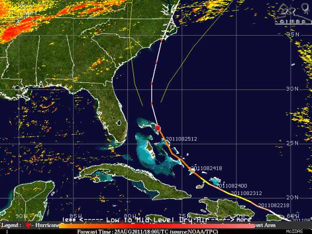
http://tropic.ssec.wisc.edu/real-time/w ... zoom=&time
http://tropic.ssec.wisc.edu/real-time/w ... oom=&time=
http://www.ssd.noaa.gov/goes/flt/t2/flash-wv.html
0 likes
-
summersquall

- Tropical Storm
- Posts: 230
- Joined: Wed Jun 16, 2010 11:23 am
- Location: Jensen Beach FL 27°N 80°W (roughly)
Eye looks fairly well defined. Seems like the peninsula (or dry air?) is taking its toll on Irene.

http://aviationweather.gov/adds/satelli ... itype=irbw
http://aviationweather.gov/adds/satelli ... itype=irbw
0 likes
My posts should NEVER, EVER, EVER be construed as an official forecast as I know virtually nada respecting the finer points of meteorology. Consequently, my posts are obviously NOT endorsed by any professional institution or the good folks at storm2k.org. For official information please refer to the weather gurus at the NHC and NWS.
-
summersquall
- Tropical Storm
- Posts: 230
- Joined: Wed Jun 16, 2010 11:23 am
- Location: Jensen Beach FL 27°N 80°W (roughly)
Some Observations From Across East Central Florida Today
Station Wind Gust (kts) Wind Gust (mph) Time (EDT)
Daytona Beach 29 kts 33 mph 315 PM
New Symrna Beach 30 kts 35 mph 447 PM
Orlando International 34 kts 39 mph 128 PM
Melbourne 34 kts 39 mph 116 PM
Vero Beach 30 kts 35 mph 507 PM
Fort Pierce 30 kts 35 mph 432 PM
Stuart 32 kts 37 mph 947 AM
Over the Atlantic Waters
Buoy 41010 (120 NM Offshore Cape Canaveral) 47 kts 54 mph Seas 19ft
Buoy 41009 (20 NM Offshore Cape Canaveral) 33 kts 38 mph Seas 12ft
Buoy 41114 (Near Fort Pierce FL) Seas 9 ft
Buoy 41113 (Near Cape Canaveral FL) Seas 7 ft
(Source: NWS Melbourne http://www.srh.noaa.gov/mlb/blog.php )
0 likes
My posts should NEVER, EVER, EVER be construed as an official forecast as I know virtually nada respecting the finer points of meteorology. Consequently, my posts are obviously NOT endorsed by any professional institution or the good folks at storm2k.org. For official information please refer to the weather gurus at the NHC and NWS.
-
tolakram
- Admin
- Posts: 19165
- Age: 60
- Joined: Sun Aug 27, 2006 8:23 pm
- Location: Florence, KY (name is Mark)
Re: ATL: IRENE - Recon
000
URNT15 KWBC 260128
NOAA2 2309A IRENE HDOB 34 20110826
011900 2821N 07515W 7518 02478 0005 +130 +124 161081 081 049 003 00
011930 2823N 07516W 7516 02479 0007 +128 +120 160082 082 050 003 00
012000 2826N 07517W 7516 02479 0006 +128 +115 160081 082 052 003 03
012030 2828N 07518W 7517 02479 0003 +132 +124 158082 082 051 004 00
012100 2830N 07520W 7517 02477 9999 +134 +125 157084 085 049 002 00
012130 2833N 07522W 7519 02474 0001 +132 +123 156085 085 049 003 00
012200 2835N 07523W 7517 02478 0003 +130 +126 155084 084 050 004 00
012230 2837N 07525W 7518 02477 0002 +131 +123 153083 084 052 001 00
012300 2840N 07526W 7517 02477 0005 +128 +120 154083 084 053 001 00
012330 2842N 07528W 7519 02475 0004 +129 +118 154084 084 052 004 00
012400 2844N 07529W 7517 02479 0006 +130 +117 153083 083 049 003 00
012430 2846N 07531W 7519 02476 0004 +131 +121 151085 086 048 004 00
012500 2849N 07532W 7517 02479 0009 +126 +127 149081 082 049 003 00
012530 2851N 07534W 7518 02476 0007 +127 +120 149080 081 047 003 00
012600 2853N 07536W 7519 02476 0002 +133 +118 148079 080 048 004 00
012630 2856N 07537W 7518 02478 0004 +131 +123 146078 078 049 006 00
012700 2858N 07539W 7518 02478 0005 +130 +126 144079 080 051 005 00
012730 2900N 07540W 7518 02478 0004 +130 +129 143078 079 049 003 00
012800 2903N 07542W 7517 02478 9997 +136 +127 143078 079 049 004 00
012830 2904N 07544W 7518 02477 9998 +137 +119 142079 081 048 003 03
0 likes
M a r k
- - - - -
Join us in chat: Storm2K Chatroom Invite. Android and IOS apps also available.
The posts in this forum are NOT official forecasts and should not be used as such. Posts are NOT endorsed by any professional institution or STORM2K.org. For official information and forecasts, please refer to NHC and NWS products.
- - - - -
Join us in chat: Storm2K Chatroom Invite. Android and IOS apps also available.
The posts in this forum are NOT official forecasts and should not be used as such. Posts are NOT endorsed by any professional institution or STORM2K.org. For official information and forecasts, please refer to NHC and NWS products.
Who is online
Users browsing this forum: No registered users and 18 guests