ATL: IRENE - Remnants - Discussion
Moderator: S2k Moderators

Re: ATL: IRENE - Hurricane - Discussion
If Irene becomes a Category 2, it would not matter because it is becoming larger. Larger hurricanes are more dangerous than smaller hurricanes because they produce higher storm surge and waves and prolonged winds that are damaging.
Last edited by Ptarmigan on Thu Aug 25, 2011 9:02 pm, edited 1 time in total.
0 likes
-
Scorpion
-
rainstorm
ATL: IRENE - Models
0 likes
-
tolakram
- Admin

- Posts: 19165
- Age: 60
- Joined: Sun Aug 27, 2006 8:23 pm
- Location: Florence, KY (name is Mark)
Re: ATL: IRENE - Recon
000
URNT15 KWBC 260138
NOAA2 2309A IRENE HDOB 35 20110826
012900 2904N 07547W 7519 02475 9998 +134 +117 140079 079 049 002 00
012930 2904N 07550W 7519 02471 9996 +132 +121 139079 079 050 002 00
013000 2904N 07552W 7519 02467 9994 +131 +122 138078 079 049 003 00
013030 2904N 07555W 7519 02465 9990 +133 +116 135077 078 050 001 00
013100 2904N 07558W 7520 02462 9985 +135 +118 135078 078 051 002 00
013130 2904N 07600W 7520 02460 9981 +137 +114 135081 083 050 002 00
013200 2903N 07603W 7520 02455 9976 +138 +112 135082 084 050 003 03
013230 2902N 07604W 7519 02454 9972 +139 +109 136076 078 052 002 00
013300 2900N 07606W 7521 02447 9970 +135 +115 135075 075 049 002 00
013330 2859N 07607W 7520 02445 9965 +138 +114 135074 077 049 001 00
013400 2858N 07609W 7519 02443 9959 +140 +114 137076 077 050 001 00
013430 2856N 07610W 7520 02438 9957 +137 +123 136077 077 049 003 00
013500 2855N 07612W 7519 02437 9954 +137 +120 135077 078 051 003 00
013530 2854N 07613W 7520 02432 9950 +138 +117 134078 078 052 002 00
013600 2852N 07615W 7520 02428 9946 +137 +116 133077 078 052 003 00
013630 2851N 07616W 7520 02426 9940 +140 +116 133078 079 054 005 00
013700 2850N 07618W 7521 02421 9941 +134 +124 133080 081 052 004 00
013730 2848N 07619W 7520 02417 9934 +136 +128 134079 079 054 008 00
013800 2847N 07621W 7518 02419 9934 +133 +137 136081 082 055 009 00
013830 2846N 07622W 7519 02411 9924 +136 +140 141078 079 056 009 00
0 likes
M a r k
- - - - -
Join us in chat: Storm2K Chatroom Invite. Android and IOS apps also available.
The posts in this forum are NOT official forecasts and should not be used as such. Posts are NOT endorsed by any professional institution or STORM2K.org. For official information and forecasts, please refer to NHC and NWS products.
-
vacanechaser

- Category 5

- Posts: 1461
- Joined: Wed Dec 03, 2003 9:34 pm
- Location: Portsmouth, Va
- Contact:
Re:
Texashawk wrote:Pressure down to 943. Think we could see a run for the 930's by tomorrow morning. Lot of similarities with Ike, really.
ok, i didnt see, nor can i find the 943 you speak of... not that i dont believe it... do you have a link for that data plaez???
Jesse V. Bass III
http://www.vastormphoto.com
Hurricane Intercept Research Team
0 likes
-
gone2beach

- S2K Supporter

- Posts: 70
- Joined: Wed Aug 27, 2008 1:20 pm
- Location: Long Beach, MS
Re:
Scorpion wrote:I agree.. the prolonged strong TS or Cat 1 winds would be devastating to those areas which are not used to such winds.
And a lot of very old structures.
0 likes

Yes Ptarmigan is right on and IKE was a prime example. Irene has a very large windfield as IKE did moving across the GOM. The amount of surge currently being pushed across hundreds of miles will be unreal. Now is the time to get out.
0 likes
The following post is NOT an official forecast and should not be used as such. It is just the opinion of the poster and may or may not be backed by sound meteorological data. It is NOT endorsed by any professional institution including storm2k.org For Official Information please refer to the NHC and NWS products.
-
tolakram
- Admin
- Posts: 19165
- Age: 60
- Joined: Sun Aug 27, 2006 8:23 pm
- Location: Florence, KY (name is Mark)
Re: ATL: IRENE - Recon
000
URNT15 KWBC 260148
NOAA2 2309A IRENE HDOB 36 20110826
013900 2844N 07624W 7519 02407 9919 +137 +141 141079 081 055 006 00
013930 2843N 07626W 7519 02401 9909 +141 +140 142084 085 057 006 00
014000 2842N 07627W 7519 02398 9905 +139 +141 139086 088 057 006 00
014030 2840N 07629W 7521 02389 9898 +141 +140 139082 083 057 007 00
014100 2839N 07630W 7522 02384 9894 +140 +142 138086 088 058 009 00
014130 2838N 07631W 7518 02386 9889 +140 +144 134090 092 059 008 00
014200 2836N 07633W 7521 02377 9880 +143 +148 133095 097 059 012 00
014230 2835N 07635W 7519 02373 9878 +139 //// 130089 091 060 012 01
014300 2834N 07636W 7520 02367 9873 +139 //// 131088 090 061 011 01
014330 2832N 07638W 7518 02362 9865 +139 //// 132092 093 061 013 01
014400 2831N 07639W 7518 02353 9855 +139 //// 131093 096 062 014 01
014430 2829N 07641W 7519 02347 9848 +139 //// 129094 097 064 015 01
014500 2828N 07642W 7523 02334 9832 +145 //// 132089 092 068 024 05
014530 2827N 07644W 7520 02330 9823 +145 //// 134094 097 069 024 01
014600 2825N 07646W 7523 02317 9810 +149 //// 138095 097 068 019 01
014630 2824N 07647W 7516 02320 9800 +152 //// 143094 095 069 016 01
014700 2823N 07648W 7523 02303 9792 +153 //// 142091 092 067 014 01
014730 2821N 07650W 7520 02303 9786 +154 //// 140088 089 067 009 01
014800 2820N 07651W 7519 02295 9776 +156 //// 140088 089 066 007 01
014830 2819N 07653W 7521 02288 9768 +156 //// 139086 087 066 007 01
0 likes
M a r k
- - - - -
Join us in chat: Storm2K Chatroom Invite. Android and IOS apps also available.
The posts in this forum are NOT official forecasts and should not be used as such. Posts are NOT endorsed by any professional institution or STORM2K.org. For official information and forecasts, please refer to NHC and NWS products.
- - - - -
Join us in chat: Storm2K Chatroom Invite. Android and IOS apps also available.
The posts in this forum are NOT official forecasts and should not be used as such. Posts are NOT endorsed by any professional institution or STORM2K.org. For official information and forecasts, please refer to NHC and NWS products.

Re:
KatDaddy wrote:Yes Ptarmigan is right on and IKE was a prime example. Irene has a very large windfield as IKE did moving across the GOM. The amount of surge currently being pushed across hundreds of miles will be unreal. Now is the time to get out.
agree...NC, LI and NYC can expect high surge than normal due to the swath of hurricane winds expanding. They will also start see this sooner rathern than later.....I was a day and half on Galveston before IKE the surge was well inland...
0 likes
-
weatherSnoop

- S2K Supporter
- Posts: 702
- Age: 61
- Joined: Wed Oct 09, 2002 10:06 pm
- Location: Tampa, FL
- Contact:
Re: ATL: IRENE - Recon Discussion
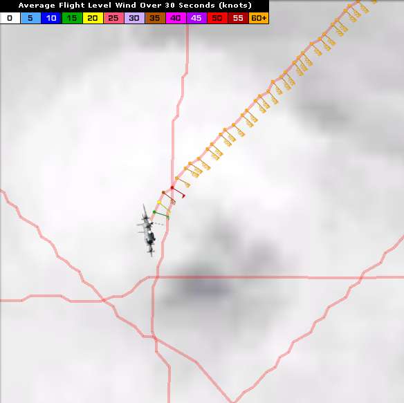
tolakram wrote:Going to need someone to take over NOAA obs and graphics please.
I was gonna help for about 30 mins, what I am looking at shows is heading for the barn. Am I on the right flt?
0 likes
-
tolakram
- Admin
- Posts: 19165
- Age: 60
- Joined: Sun Aug 27, 2006 8:23 pm
- Location: Florence, KY (name is Mark)
Re: ATL: IRENE - Recon Discussion
NOAA is up, AF headed home.
NOAA obs here: http://www.nhc.noaa.gov/text/URNT15-NOAA.shtml? posting the latest then going to bed. thanks and goodnight.
NOAA obs here: http://www.nhc.noaa.gov/text/URNT15-NOAA.shtml? posting the latest then going to bed. thanks and goodnight.
0 likes
M a r k
- - - - -
Join us in chat: Storm2K Chatroom Invite. Android and IOS apps also available.
The posts in this forum are NOT official forecasts and should not be used as such. Posts are NOT endorsed by any professional institution or STORM2K.org. For official information and forecasts, please refer to NHC and NWS products.
- - - - -
Join us in chat: Storm2K Chatroom Invite. Android and IOS apps also available.
The posts in this forum are NOT official forecasts and should not be used as such. Posts are NOT endorsed by any professional institution or STORM2K.org. For official information and forecasts, please refer to NHC and NWS products.
-
tolakram
- Admin
- Posts: 19165
- Age: 60
- Joined: Sun Aug 27, 2006 8:23 pm
- Location: Florence, KY (name is Mark)
Re: ATL: IRENE - Recon
000
URNT15 KWBC 260158
NOAA2 2309A IRENE HDOB 37 20110826
014900 2817N 07654W 7521 02278 9759 +157 //// 138087 087 066 005 01
014930 2816N 07656W 7522 02269 9749 +157 //// 137085 086 066 006 01
015000 2815N 07657W 7522 02259 9737 +159 +162 134086 088 067 005 00
015030 2813N 07659W 7521 02248 9724 +158 //// 132088 088 068 006 01
015100 2812N 07700W 7518 02241 9707 +163 +165 132089 090 069 010 00
015130 2810N 07702W 7522 02222 9690 +166 +164 131089 091 069 020 00
015200 2809N 07704W 7517 02212 9672 +165 //// 133092 093 071 018 01
015230 2808N 07705W 7522 02190 9653 +167 //// 132092 092 072 010 01
015300 2806N 07707W 7520 02172 9631 +170 //// 132092 093 074 016 01
015330 2805N 07708W 7521 02154 9607 +173 +177 127092 093 072 008 00
015400 2803N 07710W 7516 02133 9580 +171 //// 128095 099 074 017 01
015430 2802N 07712W 7515 02107 9548 +176 +177 122093 095 077 025 00
015500 2801N 07713W 7499 02092 9513 +176 +178 116088 095 081 033 00
015530 2759N 07715W 7498 02066 9473 +184 //// 117069 080 084 021 05
015600 2757N 07716W 7524 02017 9433 +191 //// 121051 055 058 003 05
015630 2756N 07718W 7527 02001 9391 +197 //// 127035 039 036 002 01
015700 2754N 07719W 7529 01990 9372 +198 //// 130022 026 024 000 01
015730 2752N 07720W 7538 01981 9406 +203 +182 107018 020 019 000 03
015800 2750N 07721W 7535 01979 9423 +201 +176 102004 005 018 000 03
015830 2748N 07721W 7516 02002 9421 +203 +164 267004 007 019 000 00
0 likes
M a r k
- - - - -
Join us in chat: Storm2K Chatroom Invite. Android and IOS apps also available.
The posts in this forum are NOT official forecasts and should not be used as such. Posts are NOT endorsed by any professional institution or STORM2K.org. For official information and forecasts, please refer to NHC and NWS products.
- - - - -
Join us in chat: Storm2K Chatroom Invite. Android and IOS apps also available.
The posts in this forum are NOT official forecasts and should not be used as such. Posts are NOT endorsed by any professional institution or STORM2K.org. For official information and forecasts, please refer to NHC and NWS products.
-
maxintensity
- Tropical Storm

- Posts: 165
- Joined: Tue Aug 02, 2011 9:54 pm
-
WilmingtonSandbar
- S2K Supporter
- Posts: 503
- Joined: Sun Aug 29, 2010 12:11 pm
- Location: Southport, NC
-
MGC

- S2K Supporter
- Posts: 5792
- Joined: Sun Mar 23, 2003 9:05 pm
- Location: Pass Christian MS, or what is left.
Re: ATL: IRENE - Hurricane - Discussion
I think Irene will be like Ike....very large top end Cat-2 or min Cat-3 with huge windfield. Surge is going to be the main issue followed by large waves then the wind. Ivan, Katrina and Ike showed what water can do....I'm afraid Irene will join the club. If Irene tracks just right, Ocracoke and Hatteras Islands will be overwashed with most structures being washed into Pamlico Sound. Even if your place is on stilts it will get destroyed. Outerbanks will be nearly totally destroyed with perhaps a few new inlets cut into the island. As the hurricane moves north, Chesapeake Bay will start to fill up with water. The Cheaspeake Bay Bridge Tunnel and Hampton Roads Bridge Tunnel could both be destroyed by wavys like the I-10 Bridges over Escambia Bay and Lake Ponchatrain. Tidewater Virginia area will see major surge flooding and the Va Beach oceanfront will see considerable damage by large waves. Wind damage to eastern NC and Tidewater VA will be considerable with power outages for 2-3 weeks. Windows will be blown out of highrise structures in Norfolk and VA Beach. The Eastern Shore of VA and MD will see considerable wind, surge and wave damage. Delaware Bay will flood by strong easterly winds. The Delaware River could flood parts of Wilmington and Philadelphia. The Jersey Shore will see considerable wave and wind damage. As Irene approaches NYC flooding surge will enter through Verrazno Narrows resulting in flooding in the NYC area. Long Island will be battered by large waves.....sound pretty scarry? I think this could very well happen this weekend.
Irene is starting to regain organization tonight. The hurricane has reestablished its eye on the IR satellite and convection is wrapping around the eye. Expect continued central pressure drops and the wind will eventually mix down to the surface.
The above is the opinion of MGC and not an official forecast. Check with the NHC and local authorities.
0 likes
-
tolakram
- Admin
- Posts: 19165
- Age: 60
- Joined: Sun Aug 27, 2006 8:23 pm
- Location: Florence, KY (name is Mark)
Re: ATL: IRENE - Recon
0 likes
M a r k
- - - - -
Join us in chat: Storm2K Chatroom Invite. Android and IOS apps also available.
The posts in this forum are NOT official forecasts and should not be used as such. Posts are NOT endorsed by any professional institution or STORM2K.org. For official information and forecasts, please refer to NHC and NWS products.
- - - - -
Join us in chat: Storm2K Chatroom Invite. Android and IOS apps also available.
The posts in this forum are NOT official forecasts and should not be used as such. Posts are NOT endorsed by any professional institution or STORM2K.org. For official information and forecasts, please refer to NHC and NWS products.

-
amawea

- S2K Supporter
- Posts: 385
- Age: 72
- Joined: Mon Aug 09, 2004 3:36 pm
- Location: Horseshoe Bend, Ar. but from Baytown, Tx
Re:
summersquall wrote:Eye looks fairly well defined. Seems like the peninsula (or dry air?) is taking its toll on Irene.
http://aviationweather.gov/adds/satelli ... itype=irbw

I believe Irene is taking a toll on dry air. This speaks for itself.
000
AXNT20 KNHC 252356
TWDAT
TROPICAL WEATHER DISCUSSION
NWS NATIONAL HURRICANE CENTER MIAMI FL
805 PM EDT THU AUG 25 2011
TROPICAL WEATHER DISCUSSION FOR NORTH AMERICA...CENTRAL
AMERICA...GULF OF MEXICO...CARIBBEAN SEA...NORTHERN SECTIONS OF
SOUTH AMERICA...AND ATLANTIC OCEAN TO THE AFRICAN COAST FROM THE
EQUATOR TO 32N. THE FOLLOWING INFORMATION IS BASED ON SATELLITE
IMAGERY...WEATHER OBSERVATIONS...RADAR...AND METEOROLOGICAL
ANALYSIS.
BASED ON 1800 UTC SURFACE ANALYSIS AND SATELLITE IMAGERY THROUGH
2315 UTC.
...SPECIAL FEATURE...
HURRICANE IRENE IS CENTERED NEAR 27.7N 77.4W AT 26/0000 UTC OR
ABOUT 460 NM SSW OF CAPE HATTERAS NORTH CAROLINA MOVING NNW AT
12 KT. ESTIMATED MINIMUM CENTRAL PRESSURE IS 946 MB. MAXIMUM
SUSTAINED WIND SPEED IS 100 KT WITH GUSTS TO 120 KT. PLEASE SEE
THE LATEST INTERMEDIATE PUBLIC ADVISORY UNDER AWIPS/WMO HEADER
MIATCPAT4/WTNT34 KNHC AND THE FULL FORECAST/ADVISORY UNDER
AWIPS/WMO HEADER MIATCMAT4/WTNT24 KNHC FOR MORE DETAILS.
NUMEROUS STRONG CONVECTION IS WITHIN 75 NM OF THE CENTER.
NUMEROUS MODERATE/SCATTERED STRONG CONVECTION EXTENDS WITHIN 120
NM. SCATTERED MODERATE CONVECTION IS WITHIN 200 NM FROM THE
CENTER ALONG THE WRN SEMI-CIRCLE...AND WITHIN 300 NM ALONG THE
ERN SEMI-CIRCLE. NUMEROUS MODERATE/ISOLATED STRONG CONVECTION IS
ALSO FARTHER NE OF THE CENTER FROM 28N-32N BETWEEN 70W-79W. SOME
OF THIS HEAVY RAINFALL CONTINUES TO IMPACT THE NW BAHAMAS. OUTER
RAINBANDS HAVE ALSO ALREADY BEEN IMPACTING MUCH OF THE ERN COAST
OF FLORIDA...AND WILL SOON BE REACHING THE SOUTH CAROLINA AND
NORTH CAROLINA COASTS.
0 likes
-
maxintensity
- Tropical Storm
- Posts: 165
- Joined: Tue Aug 02, 2011 9:54 pm
Re: ATL: IRENE - Hurricane - Discussion
IMO though even if it is a cat 2 the pressure is more indicative of overall storm strength. So if it were 935mb and cat 2 then thats what it is but the pressure is more representative of strength IMO
0 likes
Re: ATL: IRENE - Hurricane - Discussion
storm surge map for Long Island and NYC.....
http://www2.sunysuffolk.edu/mandias/38h ... _zones.pdf
those people up there need to understand the swath of hurricane force winds is so wide now that there is going to be a crap load of water moving in.... more so than a typical Cat 1.....
disclaimer-- please refer to the NHC for all emergency information
0 likes
Who is online
Users browsing this forum: No registered users and 113 guests