ATL: JOSE - Remnants - Discussion

Moderator: S2k Moderators

Message
Author
User avatar
wxman57
Moderator-Pro Met
Moderator-Pro Met
Posts: 22480
Age: 66
Joined: Sat Jun 21, 2003 8:06 pm
Location: Houston, TX (southwest)

Re:

#41 Postby wxman57 » Sun Aug 28, 2011 7:23 am

Extratropical94 wrote:They probably upgraded it to prevent Bermuda from getting caught off-guard.


No, that's not it. I believe they think it might have qualified for TS strength last night or yesterday, so it's sort of a post-TS upgrade rather than a post-season upgrade. But it's definitely not a TS now. Just a weak swirl.
0 likes   

User avatar
AdamFirst
S2K Supporter
S2K Supporter
Posts: 2487
Age: 34
Joined: Thu Aug 14, 2008 10:54 am
Location: Port Saint Lucie, FL

#42 Postby AdamFirst » Sun Aug 28, 2011 7:25 am

well, we wasted the J name for this year. :D
0 likes   
Dolphins Marlins Canes Golden Panthers HEAT
Andrew 1992 - Irene 1999 - Frances 2004 - Jeanne 2004 - Wilma 2005 - Fay 2008 - Isaac 2012 - Matthew 2016 - Irma 2017 - Dorian 2019 - Ian 2022 - Nicole 2022

tolakram
Admin
Admin
Posts: 19165
Age: 60
Joined: Sun Aug 27, 2006 8:23 pm
Location: Florence, KY (name is Mark)

Re: ATL: JOSE - Tropical Storm - Discussion

#43 Postby tolakram » Sun Aug 28, 2011 7:26 am

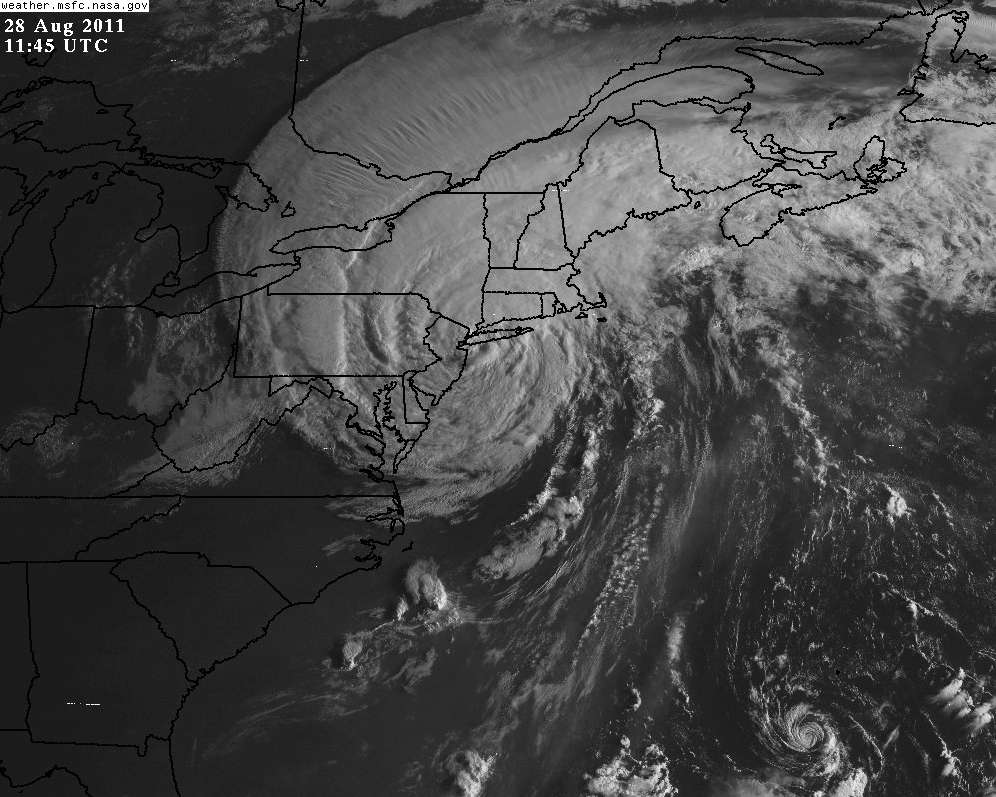
Same thing I posted in the Irene thread ...

Jose and big sister Irene.

Image
0 likes   
M a r k
- - - - -
Join us in chat: Storm2K Chatroom Invite. Android and IOS apps also available.

The posts in this forum are NOT official forecasts and should not be used as such. Posts are NOT endorsed by any professional institution or STORM2K.org. For official information and forecasts, please refer to NHC and NWS products.

User avatar
Extratropical94
Professional-Met
Professional-Met
Posts: 3535
Age: 29
Joined: Wed Oct 20, 2010 6:36 am
Location: Hamburg, Germany
Contact:

Re: Re:

#44 Postby Extratropical94 » Sun Aug 28, 2011 7:29 am

wxman57 wrote:
Extratropical94 wrote:They probably upgraded it to prevent Bermuda from getting caught off-guard.


No, that's not it. I believe they think it might have qualified for TS strength last night or yesterday, so it's sort of a post-TS upgrade rather than a post-season upgrade. But it's definitely not a TS now. Just a weak swirl.


If so, then they could've done the same with the area of circulation that developed from the front that produced Franklin (I think it was designated 96L or so).
Then we wouldn't have to use the name of Katrina's successor for possible land-threatening 92L.
Just a thought ;)
0 likes   
54° 11' 59'' N, 9° 9' 20'' E
Boomer Sooner!
Go Broncos! Go Cards! Go Niners!
- Daniel

User avatar
cycloneye
Admin
Admin
Posts: 139067
Age: 67
Joined: Thu Oct 10, 2002 10:54 am
Location: San Juan, Puerto Rico

Re: ATL: JOSE - Tropical Storm - Discussion

#45 Postby cycloneye » Sun Aug 28, 2011 7:38 am

57,it was a TS since 06z.

AL, 11, 2011082806, , BEST, 0, 297N, 654W, 35, 1009, TS, 34, NEQ, 45, 45, 0, 0, 1012, 90, 30, 45, 0, L, 0, , 0, 0, INVEST, S,
AL, 11, 2011082812, , BEST, 0, 309N, 657W, 35, 1008, TS
0 likes   
Visit the Caribbean-Central America Weather Thread where you can find at first post web cams,radars
and observations from Caribbean basin members Click Here

User avatar
SEASON_CANCELED
Category 3
Category 3
Posts: 887
Joined: Mon Jul 06, 2009 5:17 am
Location: 8 Bit Charlie Sheen

Re: ATL: JOSE - Tropical Storm - Discussion

#46 Postby SEASON_CANCELED » Sun Aug 28, 2011 7:42 am

is that little midget swirl Jose?
0 likes   
i am a big stupid ugly moron with an ugly face and a big butt and my butt stinks and i like to kiss my own butt

tolakram
Admin
Admin
Posts: 19165
Age: 60
Joined: Sun Aug 27, 2006 8:23 pm
Location: Florence, KY (name is Mark)

Re: ATL: JOSE - Tropical Storm - Discussion

#47 Postby tolakram » Sun Aug 28, 2011 7:45 am

SEASON_CANCELED wrote:is that little midget swirl Jose?


Yes, in the lower right hand corner of the image.
0 likes   
M a r k
- - - - -
Join us in chat: Storm2K Chatroom Invite. Android and IOS apps also available.

The posts in this forum are NOT official forecasts and should not be used as such. Posts are NOT endorsed by any professional institution or STORM2K.org. For official information and forecasts, please refer to NHC and NWS products.

User avatar
SEASON_CANCELED
Category 3
Category 3
Posts: 887
Joined: Mon Jul 06, 2009 5:17 am
Location: 8 Bit Charlie Sheen

Re: ATL: JOSE - Tropical Storm - Discussion

#48 Postby SEASON_CANCELED » Sun Aug 28, 2011 7:53 am

tolakram wrote:
SEASON_CANCELED wrote:is that little midget swirl Jose?


Yes, in the lower right hand corner of the image.


Wow. its so tiny, thats almost the size of tracy!
0 likes   
i am a big stupid ugly moron with an ugly face and a big butt and my butt stinks and i like to kiss my own butt

maxx9512
Tropical Storm
Tropical Storm
Posts: 114
Age: 64
Joined: Thu May 31, 2007 7:55 pm
Location: Cape Coral, Fl.

Re: ATL: JOSE - Tropical Storm - Discussion

#49 Postby maxx9512 » Sun Aug 28, 2011 7:58 am

Jose would fit in whats left of the center of Irene. It looks pretty funny
in the same picture. I guess if it qualifies for T.S. status, name it.
0 likes   

User avatar
Recurve
Category 5
Category 5
Posts: 1630
Joined: Tue Aug 16, 2005 8:59 pm
Location: St. Petersburg, FL

Re: ATL: JOSE - Tropical Storm - Discussion

#50 Postby Recurve » Sun Aug 28, 2011 8:02 am

Awwwwww, that's cute.

(Don't flame me! I know any system could impact someone. Just some comic relief after the massive disaster that has been Irene.)
0 likes   

User avatar
Janie2006
Category 5
Category 5
Posts: 1293
Joined: Mon Sep 18, 2006 3:28 pm
Location: coastal Ms aka home of the hurricanes

Re: ATL: JOSE - Tropical Storm - Discussion

#51 Postby Janie2006 » Sun Aug 28, 2011 8:30 am

Granted that there's really no comparison between Jose and Irene at this point, but the juxtaposition of the two systems in the same satellite photo is rather striking. Looks like Jose is going fishing at the moment.
0 likes   

User avatar
Andrew92
S2K Supporter
S2K Supporter
Posts: 3247
Age: 40
Joined: Mon Jun 16, 2003 12:35 am
Location: Phoenix, Arizona

#52 Postby Andrew92 » Sun Aug 28, 2011 9:30 am

I'm sorry, but this is the most ridiculous upgrade to a tropical storm I have ever seen in my life. Where is the deep convection that the discussion claims there is???

-Andrew92
0 likes   

User avatar
Chacor
Category 5
Category 5
Posts: 10229
Joined: Mon Oct 02, 2006 10:43 pm
Location: Singapore

#53 Postby Chacor » Sun Aug 28, 2011 9:38 am

Latest Bermuda METAR: TXKF 281355Z 14019KT 9999 FEW021 SCT050 29/23 Q1013
0 likes   

User avatar
cycloneye
Admin
Admin
Posts: 139067
Age: 67
Joined: Thu Oct 10, 2002 10:54 am
Location: San Juan, Puerto Rico

Re: ATL: JOSE - Tropical Storm - Discussion

#54 Postby cycloneye » Sun Aug 28, 2011 9:48 am

0 likes   
Visit the Caribbean-Central America Weather Thread where you can find at first post web cams,radars
and observations from Caribbean basin members Click Here

User avatar
cycloneye
Admin
Admin
Posts: 139067
Age: 67
Joined: Thu Oct 10, 2002 10:54 am
Location: San Juan, Puerto Rico

Re: ATL: JOSE - Advisories

#55 Postby cycloneye » Sun Aug 28, 2011 9:49 am

TROPICAL STORM JOSE DISCUSSION NUMBER 2
NWS NATIONAL HURRICANE CENTER MIAMI FL AL112011
1100 AM AST SUN AUG 28 2011

THERE HAS NOT BEEN MUCH CHANGE IN THE ORGANIZATION OF JOSE IN RECENT
HOURS. CONVECTION HAS BEEN RE-DEVELOPING NEAR AND EAST OF THE
CENTER...BUT STRONG NORTHEASTERLY SHEAR IN ASSOCIATION WITH THE
OUTFLOW OF HURRICANE IRENE HAS PREVENTED ANY BURST FROM LASTING
TOO LONG. EARLIER ASCAT DATA SUGGESTED THAT THE INTENSITY WAS NEAR
35 KT...AND WITH NO SIGNIFICANT CHANGE TO THE CLOUD PATTERN...
THIS WILL BE THE INITIAL INTENSITY. ALTHOUGH THERE COULD BE SOME
REDUCTION IN THE SHEAR DURING THE NEXT DAY OR TWO...IT WOULD NOT
LIKELY BE ENOUGH TO PREVENT WEAKENING AS THE CIRCULATION OF JOSE
BECOMES DEFORMED. GLOBAL MODELS INDICATE DISSIPATION WITHIN 24-36
HOURS IN PART BECAUSE OF THE SHEAR...AND THE OFFICIAL NHC FORECAST
REFLECTS THIS LIKELIHOOD.

THE INITIAL MOTION ESTIMATE IS 350/12. JOSE IS MOVING NORTHWARD
AROUND THE WEST SIDE OF A LOW-/MID-LEVEL RIDGE OVER THE CENTRAL
ATLANTIC. AFTER WEAKENING...THE REMNANTS OF JOSE SHOULD TURN NORTH-
NORTHEASTWARD WITH SOME INCREASE IN FORWARD SPEED BEFORE LOSING ITS
IDENTITY.

FORECAST POSITIONS AND MAX WINDS

INIT 28/1500Z 31.5N 65.7W 35 KT 40 MPH
12H 29/0000Z 33.6N 66.0W 35 KT 40 MPH
24H 29/1200Z 36.6N 65.6W 30 KT 35 MPH
36H 30/0000Z...DISSIPATED

$$
FORECASTER KIMBERLAIN/PASCH
0 likes   
Visit the Caribbean-Central America Weather Thread where you can find at first post web cams,radars
and observations from Caribbean basin members Click Here

User avatar
Tampa_God
Category 1
Category 1
Posts: 333
Age: 34
Joined: Wed May 31, 2006 7:27 pm
Location: New Port Richey/Trinity, FL

Re:

#56 Postby Tampa_God » Sun Aug 28, 2011 10:07 am

Do we know the circumference of Jose yet? Trying to compare his size and Tracy's size on what it would look like like over Florida and they seem fairly around the same size.
0 likes   

RL3AO
Moderator-Pro Met
Moderator-Pro Met
Posts: 16308
Joined: Thu Jun 14, 2007 10:03 pm
Location: NC

Re: Re:

#57 Postby RL3AO » Sun Aug 28, 2011 10:09 am

Tampa_God wrote:Do we know the circumference of Jose yet? Trying to compare his size and Tracy's size on what it would look like like over Florida and they seem fairly around the same size.


Since its almost extra tropical the winds spread out fairly well for a 35kt storm

34 KT....... 45NE 45SE 0SW 0NW.

However, don't insult Tracy by comparing this garbage to it. Tracy was a category 4 cyclone. :lol:
0 likes   

User avatar
Chacor
Category 5
Category 5
Posts: 10229
Joined: Mon Oct 02, 2006 10:43 pm
Location: Singapore

#58 Postby Chacor » Sun Aug 28, 2011 10:09 am

Remember, TC size is not determined by physical extent, but by radius of gale (or sometimes, more rarely maximum) winds. There's no guarantee Tracy even holds the record any more, iirc Marco in the Atlantic a few years ago had a very tiny windfield and came close to the record, although the NHC never mentioned it operationally.

EDIT: I see that NOAA currently considers Marco to be the record holder. http://www.aoml.noaa.gov/hrd/tcfaq/E5.html
Last edited by Chacor on Sun Aug 28, 2011 10:12 am, edited 1 time in total.
0 likes   

User avatar
Extratropical94
Professional-Met
Professional-Met
Posts: 3535
Age: 29
Joined: Wed Oct 20, 2010 6:36 am
Location: Hamburg, Germany
Contact:

Re: Re:

#59 Postby Extratropical94 » Sun Aug 28, 2011 10:12 am

Tampa_God wrote:Do we know the circumference of Jose yet? Trying to compare his size and Tracy's size on what it would look like like over Florida and they seem fairly around the same size.


TROPICAL-STORM-FORCE WINDS EXTEND OUTWARD UP TO 50 MILES...85 KM
FROM THE CENTER.

Tracy had 30 mi. gale force winds, but it was a LOT stronger (Cat. 4 from BOM, Cat. 3 SSHS)
Tropical storm Marco (2008) had a gale diameter of only 12 mi. (TS with 65 mph winds)
0 likes   
54° 11' 59'' N, 9° 9' 20'' E
Boomer Sooner!
Go Broncos! Go Cards! Go Niners!
- Daniel

tolakram
Admin
Admin
Posts: 19165
Age: 60
Joined: Sun Aug 27, 2006 8:23 pm
Location: Florence, KY (name is Mark)

Re:

#60 Postby tolakram » Sun Aug 28, 2011 10:12 am

Andrew92 wrote:I'm sorry, but this is the most ridiculous upgrade to a tropical storm I have ever seen in my life. Where is the deep convection that the discussion claims there is???

-Andrew92


It was upgraded this morning just before deep convection dissipated. It was heading toward Bermuda. Of course before calling it "the most ridiculous upgrade to a tropical storm I have ever seen in my life" you checked out the facts, right? :) Sorry, but that statement is rather strong.
0 likes   
M a r k
- - - - -
Join us in chat: Storm2K Chatroom Invite. Android and IOS apps also available.

The posts in this forum are NOT official forecasts and should not be used as such. Posts are NOT endorsed by any professional institution or STORM2K.org. For official information and forecasts, please refer to NHC and NWS products.


Return to “2011”

Who is online

Users browsing this forum: No registered users and 107 guests