BEGIN
NHC_ATCF
invest_al942011.invest
FSTDA
R
U
040
010
0000
201109011236
NONE
NOTIFY=ATRP
END
INVEST, AL, L, , , , , 94, 2011, DB, O, 2011090112, 9999999999, , , , , , METWATCH, , AL942011
AL, 94, 2011090112, , BEST, 0, 375N, 637W, 25, 0, DB, 0, , 0, 0, 0, 0,
ATL: INVEST 94L - Discussion
Moderator: S2k Moderators
-
HURAKAN

- Professional-Met

- Posts: 46086
- Age: 37
- Joined: Thu May 20, 2004 4:34 pm
- Location: Key West, FL
- Contact:
ATL: INVEST 94L - Discussion
0 likes


Looks like yet ANOTHER TS that has formed in the W.Atlantic...
It reminds me an awful lot of the 2005 season where we had a glut of TS/hurricanes in the Ne Atlantic, focus is further west but I think if this continues we should go 20+ for storms...
IMO thats a TS already...
It reminds me an awful lot of the 2005 season where we had a glut of TS/hurricanes in the Ne Atlantic, focus is further west but I think if this continues we should go 20+ for storms...
IMO thats a TS already...
0 likes
Personal Forecast Disclaimer:
The posts in this forum are NOT official forecast and should not be used as such. They are just the opinion of the poster and may or may not be backed by sound meteorological data. They are NOT endorsed by any professional institution or storm2k.org. For official information, please refer to the NHC and NWS products
The posts in this forum are NOT official forecast and should not be used as such. They are just the opinion of the poster and may or may not be backed by sound meteorological data. They are NOT endorsed by any professional institution or storm2k.org. For official information, please refer to the NHC and NWS products

Re: ATL: INVEST 94L
Last edited by Macrocane on Thu Sep 01, 2011 8:20 am, edited 1 time in total.
0 likes
-
SouthDadeFish

- Professional-Met
- Posts: 2835
- Joined: Thu Sep 23, 2010 2:54 pm
- Location: Miami, FL
- Contact:
-
SouthDadeFish
- Professional-Met
- Posts: 2835
- Joined: Thu Sep 23, 2010 2:54 pm
- Location: Miami, FL
- Contact:
-
Hurricanehink

- S2K Supporter

- Posts: 2022
- Joined: Sun Nov 16, 2003 2:05 pm
- Location: New Jersey
Re: ATL: INVEST 94L
Is there any reason it isn't higher than yellow? Is it still frontal, perhaps?
0 likes
-
Aric Dunn
- Category 5

- Posts: 21228
- Age: 41
- Joined: Sun Sep 19, 2004 9:58 pm
- Location: Ready for the Chase.
- Contact:
it should be LEE or at least a tropical depression
0 likes
Note: If I make a post that is brief. Please refer back to previous posts for the analysis or reasoning. I do not re-write/qoute what my initial post said each time.
If there is nothing before... then just ask
Space & Atmospheric Physicist, Embry-Riddle Aeronautical University,
I believe the sky is falling...
If there is nothing before... then just ask
Space & Atmospheric Physicist, Embry-Riddle Aeronautical University,
I believe the sky is falling...
Re: ATL: INVEST 94L
Hurricanehink wrote:Is there any reason it isn't higher than yellow? Is it still frontal, perhaps?
According to the latest surface analisys it is embedded within a stationary front, but it looks like it has detached.
0 likes
-
ColinDelia

- S2K Supporter
- Posts: 918
- Joined: Mon Aug 29, 2005 5:52 am
- Location: The Beach, FL

Looks pretty decent there, agree that it should be a named storm.
*NOT an official forecast and should not be used as such. It is my opinion and may or may not be backed by sound meteorological data. They are NOT endorsed by any professional institution or storm2k.org. For official information, please refer to the NHC and NWS products.
*NOT an official forecast and should not be used as such. It is my opinion and may or may not be backed by sound meteorological data. They are NOT endorsed by any professional institution or storm2k.org. For official information, please refer to the NHC and NWS products.
0 likes

-
tolakram
- Admin

- Posts: 19165
- Age: 60
- Joined: Sun Aug 27, 2006 8:23 pm
- Location: Florence, KY (name is Mark)
Re: ATL: INVEST 94L
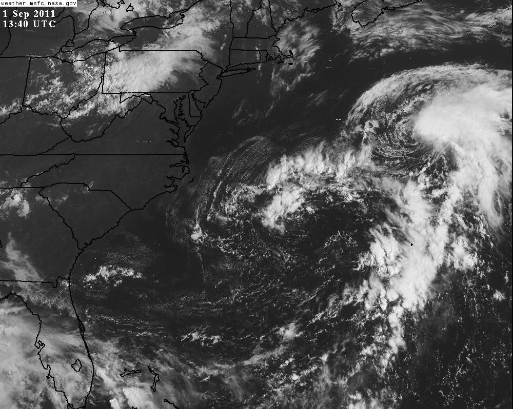
Very edge of the GOES east coast pic.
Live loop: http://wwwghcc.msfc.nasa.gov/cgi-bin/ge ... umframes=5
copy of latest frame
Live loop: http://wwwghcc.msfc.nasa.gov/cgi-bin/ge ... umframes=5
copy of latest frame
0 likes
M a r k
- - - - -
Join us in chat: Storm2K Chatroom Invite. Android and IOS apps also available.
The posts in this forum are NOT official forecasts and should not be used as such. Posts are NOT endorsed by any professional institution or STORM2K.org. For official information and forecasts, please refer to NHC and NWS products.
-
SFLcane

- S2K Supporter
- Posts: 9606
- Age: 46
- Joined: Sat Jun 05, 2010 1:44 pm
- Location: Lake Worth Florida
Re:
KWT wrote:Looks like yet ANOTHER TS that has formed in the W.Atlantic...
It reminds me an awful lot of the 2005 season where we had a glut of TS/hurricanes in the Ne Atlantic, focus is further west but I think if this continues we should go 20+ for storms...
IMO thats a TS already...
Heading for greek if this continues...difference from the mighty 2005 is no signifcant landfalls other then irene thus far this season.
0 likes
-
tolakram
- Admin
- Posts: 19165
- Age: 60
- Joined: Sun Aug 27, 2006 8:23 pm
- Location: Florence, KY (name is Mark)
Re: ATL: INVEST 94L
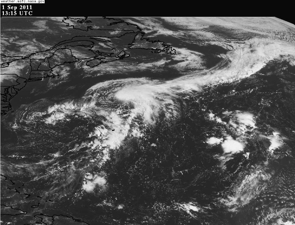
This live loop from the NH extended view. You can see what might be the associated front.
slow to load for me.
http://wwwghcc.msfc.nasa.gov/cgi-bin/ge ... umframes=5
copy of latest image
slow to load for me.
http://wwwghcc.msfc.nasa.gov/cgi-bin/ge ... umframes=5
copy of latest image
0 likes
M a r k
- - - - -
Join us in chat: Storm2K Chatroom Invite. Android and IOS apps also available.
The posts in this forum are NOT official forecasts and should not be used as such. Posts are NOT endorsed by any professional institution or STORM2K.org. For official information and forecasts, please refer to NHC and NWS products.
- - - - -
Join us in chat: Storm2K Chatroom Invite. Android and IOS apps also available.
The posts in this forum are NOT official forecasts and should not be used as such. Posts are NOT endorsed by any professional institution or STORM2K.org. For official information and forecasts, please refer to NHC and NWS products.
-
northjaxpro

- S2K Supporter
- Posts: 8900
- Joined: Mon Sep 27, 2010 11:21 am
- Location: Jacksonville, FL
Re: ATL: INVEST 94L
I agree with those who stated that this system looks detached from the frontal boundary. At the very least, this appears to be a TD or even a minimal TS right now. Also, should it get designated as either from the NHC, this would make it the sixth tropical entity to form in the Atlantic Basin north of 25 latitude. That has been amazing stat this season to this point.
0 likes
NEVER, EVER SAY NEVER in the tropics and weather in general, and most importantly, with life itself!!
________________________________________________________________________________________
Fay 2008 Beryl 2012 Debby 2012 Colin 2016 Hermine 2016 Julia 2016 Matthew 2016 Irma 2017 Dorian 2019
________________________________________________________________________________________
Fay 2008 Beryl 2012 Debby 2012 Colin 2016 Hermine 2016 Julia 2016 Matthew 2016 Irma 2017 Dorian 2019
-
wxman57

- Moderator-Pro Met

- Posts: 22480
- Age: 66
- Joined: Sat Jun 21, 2003 8:06 pm
- Location: Houston, TX (southwest)
Re: ATL: INVEST 94L
Jose = TS and this = 10%????? Something is not right with the universe...
0 likes
-
Extratropical94

- Professional-Met
- Posts: 3535
- Age: 29
- Joined: Wed Oct 20, 2010 6:36 am
- Location: Hamburg, Germany
- Contact:
Re: ATL: INVEST 94L
wxman57 wrote:Jose = TS and this = 10%????? Something is not right with the universe...
I fully agree. The NHC seems to be sort of inconsequent with watching the subtropical latitudes and storms forming there.
They totally missed 96L (the one after Franklin I think), and they overhyped Jose for no real reason (well, TS winds affected Bermuda, but they are used to this level of breeziness.)
Take 96L as Gert, then this one would be Maria and the GOM brewer Nate.
And now look at today's date.
Edit: I do not want to be/sound rude, but I would love to have the agencies follow a clearer line when it comes to those frontal/subtropical storms.
0 likes
54° 11' 59'' N, 9° 9' 20'' E
Boomer Sooner!
Go Broncos! Go Cards! Go Niners!
- Daniel
Boomer Sooner!
Go Broncos! Go Cards! Go Niners!
- Daniel
-
HURAKAN
- Professional-Met
- Posts: 46086
- Age: 37
- Joined: Thu May 20, 2004 4:34 pm
- Location: Key West, FL
- Contact:
ATL: INVEST 94L - Models

Code: Select all
TROPICAL CYCLONE GUIDANCE MESSAGE
NWS NATIONAL HURRICANE CENTER MIAMI FL
1403 UTC THU SEP 1 2011

DISCLAIMER...NUMERICAL MODELS ARE SUBJECT TO LARGE ERRORS.
PLEASE REFER TO NHC OFFICIAL FORECASTS FOR TROPICAL CYCLONE
AND SUBTROPICAL CYCLONE INFORMATION.

ATLANTIC OBJECTIVE AIDS FOR

DISTURBANCE INVEST (AL942011) 20110901 1200 UTC

        ...00 HRS...   ...12 HRS...   ...24 HRS. ..   ...36 HRS...
        110901  1200   110902  0000   110902  1200   110903  0000

         LAT    LON     LAT    LON     LAT    LON     LAT    LON
BAMS    37.4N  63.9W   38.1N  64.8W   38.7N  65.6W   39.2N  66.0W
BAMD    37.4N  63.9W   38.6N  63.2W   40.6N  62.0W   43.0N  60.3W
BAMM    37.4N  63.9W   38.2N  64.2W   39.4N  64.3W   40.6N  64.2W
LBAR    37.4N  63.9W   38.0N  62.9W   39.0N  62.1W   40.6N  60.7W
SHIP        35KTS          44KTS          51KTS          53KTS
DSHP        35KTS          44KTS          51KTS          53KTS

        ...48 HRS...   ...72 HRS...   ...96 HRS. ..   ..120 HRS...
        110903  1200   110904  1200   110905  1200   110906  1200

         LAT    LON     LAT    LON     LAT    LON     LAT    LON
BAMS    39.6N  65.8W   41.7N  62.3W   45.1N  55.4W   48.4N  48.4W
BAMD    45.0N  57.3W   47.4N  45.4W   46.0N  34.0W   45.7N  25.7W
BAMM    41.7N  63.5W   44.4N  57.6W   46.8N  45.7W   46.2N  34.5W
LBAR    42.1N  58.4W   44.3N  49.3W   46.2N  38.3W   45.0N  31.5W
SHIP        48KTS          41KTS          30KTS          21KTS
DSHP        48KTS          41KTS          30KTS          21KTS

         ...INITIAL CONDITIONS...
LATCUR =  37.4N LONCUR =  63.9W DIRCUR =  40DEG SPDCUR =   2KT
LATM12 =  37.2N LONM12 =  64.1W DIRM12 =  38DEG SPDM12 =   1KT
LATM24 =  36.9N LONM24 =  64.4W
WNDCUR =   35KT RMAXWD =   45NM WNDM12 =   25KT
CENPRS = 1008MB OUTPRS = 1012MB OUTRAD =   75NM SDEPTH =   S
RD34NE =   45NM RD34SE =    0NM RD34SW =    0NM RD34NW =   0NM

$$
NNNN
0 likes
Who is online
Users browsing this forum: No registered users and 45 guests