Here's hoping it's not going to intensify too much before it hits Luzon but the rainfall is probably going to be a big big issue regardless.
Beyond the Luzon landfall I'm actually rather, well, how should I say, open-minded regarding the track. I reckon we're gonna see quite a number of shifts with the forecast track in the lead up to the second, neither Hong Kong nor Vietnam are in the clear here.
Personal Forecast Disclaimer:
The posts in this forum are NOT official forecast and should not be used as such. They are just the opinion of the poster and may or may not be backed by sound meteorological data. They are NOT endorsed by any professional institution or storm2k.org
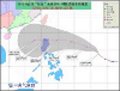
WPAC: NESAT - Tropical Storm (20W)
Moderator: S2k Moderators
-
apocalypt-flyer
- Category 1

- Posts: 468
- Joined: Sat Aug 27, 2005 11:51 am
-
cycloneye

- Admin

- Posts: 139026
- Age: 67
- Joined: Thu Oct 10, 2002 10:54 am
- Location: San Juan, Puerto Rico
Re: WPAC: NESAT - Typhoon (20W)
JMA has upgraded to Typhoon.
TY 1117 (NESAT)
Issued at 21:45 UTC, 25 September 2011
<Analyses at 25/21 UTC>
Scale -
Intensity Strong
Center position N15°00'(15.0°)
E126°40'(126.7°)
Direction and speed of movement W 15km/h(9kt)
Central pressure 970hPa
Maximum wind speed near the center 35m/s(65kt)
Maximum wind gust speed 50m/s(95kt)
Area of 50kt winds or more ALL130km(70NM)
Area of 30kt winds or more N500km(270NM)
S410km(220NM)
0 likes
Visit the Caribbean-Central America Weather Thread where you can find at first post web cams,radars
and observations from Caribbean basin members Click Here
and observations from Caribbean basin members Click Here
-
dexterlabio
- Category 5

- Posts: 3406
- Joined: Sat Oct 24, 2009 11:50 pm
Re: WPAC: NESAT - Typhoon (20W)
Do anyone has a pic for the rain rate? It began raining in my place at 4am and since then the rain has never ceased. Looking at the satpic, there are tremendous amount of convection over the center and the western part of the rainbands.
0 likes
Personal Forecast Disclaimer:
The posts in this forum are NOT official forecast and should not be used as such. They are just the opinion of the poster and may or may not be backed by sound meteorological data. They are NOT endorsed by any professional institution or storm2k.org. For official information, please refer to the NHC and NWS products.
The posts in this forum are NOT official forecast and should not be used as such. They are just the opinion of the poster and may or may not be backed by sound meteorological data. They are NOT endorsed by any professional institution or storm2k.org. For official information, please refer to the NHC and NWS products.
-
dexterlabio
- Category 5
- Posts: 3406
- Joined: Sat Oct 24, 2009 11:50 pm
Re: Re:
RobWESTPACWX wrote:dhoeze wrote:Hope our mountain ranges along the east side of Luzon weakens this typhoon...
Really do hope so to, flip side to that though is those mountains will cause a lot of flooding and landslides.
Any thing being put out there yet in Manilla? I noticed TFC really hasn't been talking about it to much .
There are news reports regarding the storm making landfall in Aurora-Isabela area, I just watched the morning news program and they reported more areas under storm warnings. Not too much about the storm but I guess they don't want to make a hype out of this too much.
0 likes
Personal Forecast Disclaimer:
The posts in this forum are NOT official forecast and should not be used as such. They are just the opinion of the poster and may or may not be backed by sound meteorological data. They are NOT endorsed by any professional institution or storm2k.org. For official information, please refer to the NHC and NWS products.
The posts in this forum are NOT official forecast and should not be used as such. They are just the opinion of the poster and may or may not be backed by sound meteorological data. They are NOT endorsed by any professional institution or storm2k.org. For official information, please refer to the NHC and NWS products.
-
dhoeze
- Tropical Storm

- Posts: 130
- Age: 42
- Joined: Tue Oct 27, 2009 2:32 am
- Location: Manila, Philippines
PAGASA Storm Signal raised around east side of Luzon
Storm Signal#2 (60-100 kph)
Isabela, Aurora,Catanduanes, Polillo Island, Camarines Norte and Camarines Sur.
Storm Singal#1 ( 30-60 kph)
Albay including Burias Island, Sorsogon, Quezon, Quirino, Ifugao, Nueva Vizcaya, Mt. Province, Kalinga and Cagayan
With the size of that storm, Metro Manila is trouble of rains.
Gurus,
Any site showing forecasted amount of rainfall that will be dropped by this system
in specific areas(if that is possible)?
Thanks.
0 likes
"Productivity is never an accident. It is always the result of a commitment to excellence, intelligent planning, and focused effort."

-
dexterlabio
- Category 5
- Posts: 3406
- Joined: Sat Oct 24, 2009 11:50 pm
Re: WPAC: NESAT - Typhoon (20W)
dhoeze, how is it in your place? Is it raining? I just want to know if the rains we are experiencing in Quezon City are localized or this is already widespread rain happening.
0 likes
Personal Forecast Disclaimer:
The posts in this forum are NOT official forecast and should not be used as such. They are just the opinion of the poster and may or may not be backed by sound meteorological data. They are NOT endorsed by any professional institution or storm2k.org. For official information, please refer to the NHC and NWS products.
The posts in this forum are NOT official forecast and should not be used as such. They are just the opinion of the poster and may or may not be backed by sound meteorological data. They are NOT endorsed by any professional institution or storm2k.org. For official information, please refer to the NHC and NWS products.
-
dhoeze
- Tropical Storm
- Posts: 130
- Age: 42
- Joined: Tue Oct 27, 2009 2:32 am
- Location: Manila, Philippines
Re: WPAC: NESAT - Typhoon (20W)
hi dexterlabio,
I am in Makati now and all we have is an overcast.
No rains yet.
I am in Makati now and all we have is an overcast.
No rains yet.
0 likes
"Productivity is never an accident. It is always the result of a commitment to excellence, intelligent planning, and focused effort."

-
dexterlabio
- Category 5
- Posts: 3406
- Joined: Sat Oct 24, 2009 11:50 pm
Re: WPAC: NESAT - Typhoon (20W)
And the dry air entrainment continues...
http://www.goes.noaa.gov/sohemi/sohemiloops/shirgmscolw.html
http://www.goes.noaa.gov/sohemi/sohemiloops/shirgmscolw.html
0 likes
Personal Forecast Disclaimer:
The posts in this forum are NOT official forecast and should not be used as such. They are just the opinion of the poster and may or may not be backed by sound meteorological data. They are NOT endorsed by any professional institution or storm2k.org. For official information, please refer to the NHC and NWS products.
The posts in this forum are NOT official forecast and should not be used as such. They are just the opinion of the poster and may or may not be backed by sound meteorological data. They are NOT endorsed by any professional institution or storm2k.org. For official information, please refer to the NHC and NWS products.
-
RobWESTPACWX
- WestPACMet

- Posts: 1616
- Joined: Fri Sep 17, 2010 2:26 am
- Location: Tokyo, Japan
- Contact:
Re: WPAC: NESAT - Typhoon (20W)
Latest video, think the landfall could be a little farther south than Casiguran, not by much though.
[youtube]http://www.youtube.com/watch?v=qjmOWOQHHo8[/youtube]
[youtube]http://www.youtube.com/watch?v=qjmOWOQHHo8[/youtube]
0 likes
Satellites, Charts and Forecasting tools for East Asia at WESTERNPACIFICWEATHER.COM
-
RobWESTPACWX
- WestPACMet
- Posts: 1616
- Joined: Fri Sep 17, 2010 2:26 am
- Location: Tokyo, Japan
- Contact:
Re: WPAC: NESAT - Typhoon (20W)
Eye becoming much more visible now on imagery.

0 likes
Satellites, Charts and Forecasting tools for East Asia at WESTERNPACIFICWEATHER.COM
-
phwxenthusiast
- Category 2

- Posts: 637
- Joined: Wed Mar 24, 2010 3:10 am
- Location: Holbrook, NY (Long Island)
-
dexterlabio
- Category 5
- Posts: 3406
- Joined: Sat Oct 24, 2009 11:50 pm
Re: WPAC: NESAT - Typhoon (20W)
^Yeah I see that I was kinda relieved at first that the dry air is killing its center but then convection wrapped around and formed the eye. Hmm by the way can I have link of the photos showing dry air around Luzon? Thanks in advance! 
It's scary though if this will do a last-minute strengthening before it makes landfall, that will bring much impact than a system weakening prior to landfall.
I
It's scary though if this will do a last-minute strengthening before it makes landfall, that will bring much impact than a system weakening prior to landfall.
I
0 likes
Personal Forecast Disclaimer:
The posts in this forum are NOT official forecast and should not be used as such. They are just the opinion of the poster and may or may not be backed by sound meteorological data. They are NOT endorsed by any professional institution or storm2k.org. For official information, please refer to the NHC and NWS products.
The posts in this forum are NOT official forecast and should not be used as such. They are just the opinion of the poster and may or may not be backed by sound meteorological data. They are NOT endorsed by any professional institution or storm2k.org. For official information, please refer to the NHC and NWS products.
-
phwxenthusiast
- Category 2
- Posts: 637
- Joined: Wed Mar 24, 2010 3:10 am
- Location: Holbrook, NY (Long Island)
-
climateconcern23
- Tropical Low

- Posts: 35
- Age: 33
- Joined: Sat Mar 05, 2011 4:38 am
- Location: Philippines
- Contact:
Re: WPAC: NESAT - Typhoon (20W)
The storm is likely moving more to west direction than wnw as mentioned.
0 likes
-
climateconcern23
- Tropical Low
- Posts: 35
- Age: 33
- Joined: Sat Mar 05, 2011 4:38 am
- Location: Philippines
- Contact:
Re: WPAC: NESAT - Typhoon (20W)
I was bothered of MTSAT Visible West Loop, on my observation it has a tiny hole on the north part near the center of circulation. But when I compared this in other loop (Guam IR Loop) the center of circulation is still in action showing to form an eye.
0 likes
-
dexterlabio
- Category 5
- Posts: 3406
- Joined: Sat Oct 24, 2009 11:50 pm
Re: WPAC: NESAT - Typhoon (20W)
I'm sure that they are having a hard time finding the true center of this storm because of the dry air entrainment that occured hours ago, there is quite huge discrepancy between JMA and JTWC position of Nesat.
TPPN11 PGTW 260612
A. TYPHOON 20W (NESAT)
B. 26/0532Z
C. 15.8N
D. 124.9E
E. FIVE/MTSAT
F. T4.0/4.5/S0.0/24HRS STT: W0.5/06HRS
G. IR/EIR/VIS/MSI
H. REMARKS: 40A/PBO SBC/ANMTN. CNVCTN WRAPS 1.10 ON LOG-10
SPIRAL YIELDING A DT OF 4.0. FT BASED ON DT. PT AND MET AGREE.
I. ADDITIONAL POSITIONS: NONE
KIENZLE
TY 1117 (NESAT)
Issued at 06:40 UTC, 26 September 2011
<Analyses at 26/06 UTC>
Scale -
Intensity Strong
Center position N15°30'(15.5°)
E125°00'(125.0°)
Direction and speed of movement WNW 20km/h(11kt)
Central pressure 965hPa
Maximum wind speed near the center 35m/s(70kt)
Maximum wind gust speed 50m/s(100kt)
Area of 50kt winds or more ALL170km(90NM)
Area of 30kt winds or more N500km(270NM)
S410km(220NM)
0 likes
Personal Forecast Disclaimer:
The posts in this forum are NOT official forecast and should not be used as such. They are just the opinion of the poster and may or may not be backed by sound meteorological data. They are NOT endorsed by any professional institution or storm2k.org. For official information, please refer to the NHC and NWS products.
The posts in this forum are NOT official forecast and should not be used as such. They are just the opinion of the poster and may or may not be backed by sound meteorological data. They are NOT endorsed by any professional institution or storm2k.org. For official information, please refer to the NHC and NWS products.
-
dexterlabio
- Category 5
- Posts: 3406
- Joined: Sat Oct 24, 2009 11:50 pm
Re: WPAC: NESAT - Typhoon (20W)
climateconcern23 wrote:I was bothered of MTSAT Visible West Loop, on my observation it has a tiny hole on the north part near the center of circulation. But when I compared this in other loop (Guam IR Loop) the center of circulation is still in action showing to form an eye.
I also find it hard to locate the eye or center of this storm, and also the direction it is tracking. The MTSAT West Visible Loop shows an area with less convection at the center, probably showing an eye but when I look at the IR and Colored IR loop, I only see a ball of convection wrapping around what seems to be the center. The visible loop also shows some kind of a westward movement than a north of west movement, the IR and Colored IR loops seems to play tricks to my eyes.
0 likes
Personal Forecast Disclaimer:
The posts in this forum are NOT official forecast and should not be used as such. They are just the opinion of the poster and may or may not be backed by sound meteorological data. They are NOT endorsed by any professional institution or storm2k.org. For official information, please refer to the NHC and NWS products.
The posts in this forum are NOT official forecast and should not be used as such. They are just the opinion of the poster and may or may not be backed by sound meteorological data. They are NOT endorsed by any professional institution or storm2k.org. For official information, please refer to the NHC and NWS products.
Who is online
Users browsing this forum: No registered users and 38 guests