Located 6N and 138E SE of PI and SW of Guam....Wonder if this is the one that ECMWF been showing the last few runs?
No Photo Yet.
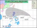
WPAC: NESAT - Tropical Storm (20W)
Moderator: S2k Moderators
-
StormingB81

- S2K Supporter

- Posts: 5676
- Age: 42
- Joined: Thu Aug 27, 2009 1:45 am
- Location: Rockledge, Florida
WPAC: NESAT - Tropical Storm (20W)
Last edited by cycloneye on Fri Sep 30, 2011 5:29 am, edited 6 times in total.
Reason: To change title
Reason: To change title
0 likes
-
climateconcern23
- Tropical Low

- Posts: 35
- Age: 33
- Joined: Sat Mar 05, 2011 4:38 am
- Location: Philippines
- Contact:

-
phwxenthusiast
- Category 2

- Posts: 637
- Joined: Wed Mar 24, 2010 3:10 am
- Location: Holbrook, NY (Long Island)
-
Typhoon Hunter
- WesternPacificWeather.com

- Posts: 1215
- Age: 40
- Joined: Wed Oct 11, 2006 11:37 am
- Location: Hong Kong
- Contact:
Re: WPAC: INVEST 98W
Hey Storming, this is the one ECM is developing.
As Pat said most models are developing this one and I think it will be the next big player in the Wpac. GFS takes it through Bashi - CMC, UKMET and ECMWF take it towards Luzon. I'll be watching this one closely!
As Pat said most models are developing this one and I think it will be the next big player in the Wpac. GFS takes it through Bashi - CMC, UKMET and ECMWF take it towards Luzon. I'll be watching this one closely!
0 likes
-
dexterlabio
- Category 5

- Posts: 3406
- Joined: Sat Oct 24, 2009 11:50 pm
Re: WPAC: INVEST 98W
Too bad the NCEP page put out the simpler track map showing the model runs from Euro. Maybe they knew I was sneaking on pages that are supposed to be restricted to some. 
I'm waiting for the 00z run to see if there will be any changes, though I really feel that this one is SCS-bound.
I'm waiting for the 00z run to see if there will be any changes, though I really feel that this one is SCS-bound.
0 likes
Personal Forecast Disclaimer:
The posts in this forum are NOT official forecast and should not be used as such. They are just the opinion of the poster and may or may not be backed by sound meteorological data. They are NOT endorsed by any professional institution or storm2k.org. For official information, please refer to the NHC and NWS products.
The posts in this forum are NOT official forecast and should not be used as such. They are just the opinion of the poster and may or may not be backed by sound meteorological data. They are NOT endorsed by any professional institution or storm2k.org. For official information, please refer to the NHC and NWS products.
-
dexterlabio
- Category 5
- Posts: 3406
- Joined: Sat Oct 24, 2009 11:50 pm
Re: WPAC: INVEST 98W
As of now the shear isn't that friendly to support a significant strengthening, but you can see that the shear is decreasing on the area around this system and also along its potential track. That's when the action starts.

0 likes
Personal Forecast Disclaimer:
The posts in this forum are NOT official forecast and should not be used as such. They are just the opinion of the poster and may or may not be backed by sound meteorological data. They are NOT endorsed by any professional institution or storm2k.org. For official information, please refer to the NHC and NWS products.
The posts in this forum are NOT official forecast and should not be used as such. They are just the opinion of the poster and may or may not be backed by sound meteorological data. They are NOT endorsed by any professional institution or storm2k.org. For official information, please refer to the NHC and NWS products.
-
ManilaTC

- WesternPacificWeather.com
- Posts: 592
- Age: 45
- Joined: Mon Oct 26, 2009 5:13 am
- Location: Mandaluyong City, Philippines
- Contact:
Re: WPAC: INVEST 98W

Here is a nice ASCAT shot of a circulation forming east of Palau.
0 likes
The above post is NOT official and should not be used as such. It is my opinion and may or may not be backed by sound meteorological data. It is not endorsed by any professional institution or storm2k.org. Please refer to your official national weather agency.
WEB http://goo.gl/JDiKXB | FB https://goo.gl/N5sIle | @ManilaTC
WEB http://goo.gl/JDiKXB | FB https://goo.gl/N5sIle | @ManilaTC

Re: WPAC: INVEST 98W


ecmwf develops this and smashing luzon then intensifying in the south china sea. looks like a monster typhoon for vietnam at the end...
0 likes
Remember, all of my post aren't official. For official warnings and discussions, Please refer to your local NWS products...
NWS for the Western Pacific
https://www.weather.gov/gum/
NWS for the Western Pacific
https://www.weather.gov/gum/
Re: WPAC: INVEST 98W
AN AREA OF CONVECTION HAS PERSISTED NEAR 6.5N 137.7E,
APPROXIMATELY 190 NM EAST-SOUTHEAST OF PALAU. ANIMATED MULTI-
SPECTRAL SATELLITE IMAGERY SHOWS LOW LEVEL BANDING WRAPPING INTO A
WEAKLY DEFINED LLCC WITH FLARING CONVECTION. A 210012Z PARTIAL ASCAT
PASS INDICATES THAT THE LLCC IS LOCATED AT THE EASTERN EXTENT OF THE
MONSOON TROUGH, WHICH APPEARS TO BE RE-ESTABLISHING ITSELF ACROSS
LUZON AND THE SOUTHERN PHILIPPINE SEA. THE 21/00Z UPPER LEVEL STREAM
LINE ANALYSIS INDICATES THAT THE LLCC IS LOCATED BENEATH A DIFFLUENT
ASYMPTOTE IN A REGION OF MODERATE VERTICAL WIND SHEAR. MAXIMUM
SUSTAINED SURFACE WINDS ARE ESTIMATED AT 10 TO 15 KNOTS. MINIMUM SEA
LEVEL PRESSURE IS ESTIMATED TO BE NEAR 1009 MB. THE POTENTIAL FOR
THE DEVELOPMENT OF A SIGNIFICANT TROPICAL CYCLONE WITHIN THE NEXT 24
HOURS IS LOW.
0 likes
Remember, all of my post aren't official. For official warnings and discussions, Please refer to your local NWS products...
NWS for the Western Pacific
https://www.weather.gov/gum/
NWS for the Western Pacific
https://www.weather.gov/gum/
-
dexterlabio
- Category 5
- Posts: 3406
- Joined: Sat Oct 24, 2009 11:50 pm
Re: WPAC: INVEST 98W
Relocated, upgraded to MEDIUM.
THE AREA OF CONVECTION PREVIOUSLY LOCATED NEAR 6.5N
137.7E, IS NOW LOCATED NEAR 11.1N 141.6E, APPROXIMATELY 220 NM
SOUTHWEST OF ANDERSEN AFB, GUAM. ANIMATED MULTISPECTRAL SATELLITE
IMAGERY SHOWS LOW LEVEL BANDING WRAPPING INTO AN IMPROVING LLCC WITH
FLARING DEEP CENTRAL CONVECTION. UPPER LEVEL ANALYSIS INDICATES THE
SYSTEM IS LOCATED IN AN AREA OF LOW VERTICAL WIND SHEAR, GOOD
DIVERGENCE ALOFT, AND IMPROVING OUTFLOW TO THE NORTHEAST. MAXIMUM
SUSTAINED SURFACE WINDS ARE ESTIMATED AT 15 TO 20 KNOTS. MINIMUM SEA
LEVEL PRESSURE IS ESTIMATED TO BE NEAR 1009 MB. THE POTENTIAL FOR
THE DEVELOPMENT OF A SIGNIFICANT TROPICAL CYCLONE WITHIN THE NEXT 24
HOURS IS UPGRADED TO MEDIUM.
0 likes
Personal Forecast Disclaimer:
The posts in this forum are NOT official forecast and should not be used as such. They are just the opinion of the poster and may or may not be backed by sound meteorological data. They are NOT endorsed by any professional institution or storm2k.org. For official information, please refer to the NHC and NWS products.
The posts in this forum are NOT official forecast and should not be used as such. They are just the opinion of the poster and may or may not be backed by sound meteorological data. They are NOT endorsed by any professional institution or storm2k.org. For official information, please refer to the NHC and NWS products.

Re: WPAC: INVEST 98W
Upgraded to High
(2) THE AREA OF CONVECTION PREVIOUSLY LOCATED NEAR 11.1N
141.6E IS NOW LOCATED NEAR 12.4N 138.9E, APPROXIMATELY 175 NM NORTH-
NORTHEAST OF YAP. ANIMATED INFRARED SATELLITE IMAGERY SHOWS A
CONSOLIDATING LOW LEVEL CIRCULATION CENTER (LLCC) ASSOCIATED WITH
IMPROVED CENTRAL DEEP CONVECTION. A 221642Z AMSRE MICROWAVE IMAGERY
DEPICTS CURVED LOW LEVEL CONVECTIVE BANDING. SEA LEVEL PRESSURE AT
YAP HAS DROPPED APPROXIMATELY 2 MB OVER THE PAST 24 HOURS. UPPER
LEVEL ANALYSIS INDICATES THE SYSTEM IS LOCATED IN AN AREA OF LOW
VERTICAL WIND SHEAR AND GOOD UPPER LEVEL DIVERGENCE. MAXIMUM
SUSTAINED SURFACE WINDS ARE ESTIMATED AT 15 TO 20 KNOTS. MINIMUM SEA
LEVEL PRESSURE IS ESTIMATED TO BE NEAR 1007 MB. SEE REF A (WTPN21
PGTW 202000) FOR FURTHER DETAILS. DUE TO THE IMPROVED LLCC AND DEEP
CONVECTION, THE POTENTIAL FOR THE DEVELOPMENT OF A SIGNIFICANT
TROPICAL CYCLONE WITHIN THE NEXT 24 HOURS IS UPGRADED TO HIGH.
0 likes
-
ManilaTC
- WesternPacificWeather.com
- Posts: 592
- Age: 45
- Joined: Mon Oct 26, 2009 5:13 am
- Location: Mandaluyong City, Philippines
- Contact:
Re: WPAC: INVEST 98W
TCFA Fellas!
WTPN21 PGTW 222000
MSGID/GENADMIN/NAVMARFCSTCEN PEARL HARBOR HI/JTWC//
SUBJ/TROPICAL CYCLONE FORMATION ALERT//
RMKS/
1. FORMATION OF A SIGNIFICANT TROPICAL CYCLONE IS POSSIBLE WITHIN
155 NM EITHER SIDE OF A LINE FROM 12.0N 139.8E TO 15.2N 135.2E
WITHIN THE NEXT 12 TO 24 HOURS. AVAILABLE DATA DOES NOT JUSTIFY
ISSUANCE OF NUMBERED TROPICAL CYCLONE WARNINGS AT THIS TIME.
WINDS IN THE AREA ARE ESTIMATED TO BE 15 TO 20 KNOTS. METSAT IM-
AGERY AT 221730Z INDICATES THAT A CIRCULATION CENTER IS LOCATED
NEAR 12.4N 138.9E. THE SYSTEM IS MOVING WEST-NORTHWESTWARD AT 10
KNOTS.
2. REMARKS: THE AREA OF CONVECTION PREVIOUSLY LOCATED NEAR 11.1N
141.6E IS NOW LOCATED NEAR 12.4N 138.9E, APPROXIMATELY 175 NM NORTH-
NORTHEAST OF YAP. ANIMATED INFRARED SATELLITE IMAGERY SHOWS A
CONSOLIDATING LOW LEVEL CIRCULATION CENTER (LLCC) ASSOCIATED WITH
IMPROVED CENTRAL DEEP CONVECTION. A 221642Z AMSRE MICROWAVE IMAGERY
DEPICTS CURVED LOW LEVEL CONVECTIVE BANDING. SEA LEVEL PRESSURE AT
YAP HAS DROPPED APPROXIMATELY 2 MB OVER THE PAST 24 HOURS. UPPER
LEVEL ANALYSIS INDICATES THE SYSTEM IS LOCATED IN AN AREA OF LOW
VERTICAL WIND SHEAR AND GOOD UPPER LEVEL DIVERGENCE. MAXIMUM
SUSTAINED SURFACE WINDS ARE ESTIMATED AT 15 TO 20 KNOTS. MINIMUM SEA
LEVEL PRESSURE IS ESTIMATED TO BE NEAR 1007 MB. DUE TO THE IMPROVED
LLCC AND DEEP CONVECTION, THE POTENTIAL FOR THE DEVELOPMENT OF A
SIGNIFICANT TROPICAL CYCLONE WITHIN THE NEXT 24 HOURS IS HIGH.
3. THIS ALERT WILL BE REISSUED, UPGRADED TO WARNING OR CANCELLED BY
232000Z.//
NNNN
0 likes
The above post is NOT official and should not be used as such. It is my opinion and may or may not be backed by sound meteorological data. It is not endorsed by any professional institution or storm2k.org. Please refer to your official national weather agency.
WEB http://goo.gl/JDiKXB | FB https://goo.gl/N5sIle | @ManilaTC
WEB http://goo.gl/JDiKXB | FB https://goo.gl/N5sIle | @ManilaTC
-
RobWESTPACWX
- WestPACMet

- Posts: 1616
- Joined: Fri Sep 17, 2010 2:26 am
- Location: Tokyo, Japan
- Contact:
-
RobWESTPACWX
- WestPACMet
- Posts: 1616
- Joined: Fri Sep 17, 2010 2:26 am
- Location: Tokyo, Japan
- Contact:
Re: WPAC: INVEST 98W
Really looking more and more like a TD, exposed TD but one none the less.

0 likes
Satellites, Charts and Forecasting tools for East Asia at WESTERNPACIFICWEATHER.COM

-
dexterlabio
- Category 5
- Posts: 3406
- Joined: Sat Oct 24, 2009 11:50 pm
Re: WPAC: INVEST 98W
Looking robust now. I can say it is already going there. If it will just continue to develop while staying in the Philippine Sea (without shear interfering), I don't see any reason that this won't be a major one, IMO this can be the rival of Hilary in EPAC. Also in its formative stage, the overall circulation already looks quite huge, Euro could be right in showing a fairly large system east of Luzon.
So far not good, seems that this system will make PI as a passageway before going to Southern China. Well at least PAGASA already mentioned this to the public yesterday.

From Euro


(GFS almost similar with ECMWF)
So far not good, seems that this system will make PI as a passageway before going to Southern China. Well at least PAGASA already mentioned this to the public yesterday.
From Euro
(GFS almost similar with ECMWF)
0 likes
Personal Forecast Disclaimer:
The posts in this forum are NOT official forecast and should not be used as such. They are just the opinion of the poster and may or may not be backed by sound meteorological data. They are NOT endorsed by any professional institution or storm2k.org. For official information, please refer to the NHC and NWS products.
The posts in this forum are NOT official forecast and should not be used as such. They are just the opinion of the poster and may or may not be backed by sound meteorological data. They are NOT endorsed by any professional institution or storm2k.org. For official information, please refer to the NHC and NWS products.
-
dexterlabio
- Category 5
- Posts: 3406
- Joined: Sat Oct 24, 2009 11:50 pm
Re: WPAC: INVEST 98W
Long-range from Euro. Still showing a threat to Southern China. (Notice that other one east of PI, ECM been showing that for some time now..)


0 likes
Personal Forecast Disclaimer:
The posts in this forum are NOT official forecast and should not be used as such. They are just the opinion of the poster and may or may not be backed by sound meteorological data. They are NOT endorsed by any professional institution or storm2k.org. For official information, please refer to the NHC and NWS products.
The posts in this forum are NOT official forecast and should not be used as such. They are just the opinion of the poster and may or may not be backed by sound meteorological data. They are NOT endorsed by any professional institution or storm2k.org. For official information, please refer to the NHC and NWS products.
-
dexterlabio
- Category 5
- Posts: 3406
- Joined: Sat Oct 24, 2009 11:50 pm
Maybe ECMWF is annoyed seeing their model runs posted everywhere that's why they made it totally private.  Oh well there are GFS and others, or if anyone has an access, please update us.
DT now up to 1.5 accdg to JTWC satfix, I can sense at least a 25-knot TD in their bulletin soon.
DT now up to 1.5 accdg to JTWC satfix, I can sense at least a 25-knot TD in their bulletin soon.
0 likes
Personal Forecast Disclaimer:
The posts in this forum are NOT official forecast and should not be used as such. They are just the opinion of the poster and may or may not be backed by sound meteorological data. They are NOT endorsed by any professional institution or storm2k.org. For official information, please refer to the NHC and NWS products.
The posts in this forum are NOT official forecast and should not be used as such. They are just the opinion of the poster and may or may not be backed by sound meteorological data. They are NOT endorsed by any professional institution or storm2k.org. For official information, please refer to the NHC and NWS products.
-
RobWESTPACWX
- WestPACMet
- Posts: 1616
- Joined: Fri Sep 17, 2010 2:26 am
- Location: Tokyo, Japan
- Contact:
Re: WPAC: INVEST 98W
My hobby keeps me busy making these videos. Also this tropical season is stupid busy too.
[youtube]http://www.youtube.com/watch?v=78nhyrzOT18[/youtube]
[youtube]http://www.youtube.com/watch?v=78nhyrzOT18[/youtube]
0 likes
Satellites, Charts and Forecasting tools for East Asia at WESTERNPACIFICWEATHER.COM
Who is online
Users browsing this forum: No registered users and 111 guests