WPAC: LAN - Typhoon

Moderator: S2k Moderators

Message
Author
RL3AO
Moderator-Pro Met
Moderator-Pro Met
Posts: 16308
Joined: Thu Jun 14, 2007 10:03 pm
Location: NC

Re: WPAC: LAN - Tropical Storm

#61 Postby RL3AO » Tue Oct 17, 2017 9:37 am

euro6208 wrote:[img]http://i64.tinypic.com/egwzug.gif[
[img]http://i66.tinypic.com/15hmpvk.gif[

Very much a typhoon now. Just imagine the ACE lost only because we don't have recon.


What makes you think this is a typhoon?

Image

50 to 60 knots seems right to me.
2 likes   

User avatar
doomhaMwx
Category 5
Category 5
Posts: 2398
Age: 25
Joined: Tue Apr 18, 2017 4:01 am
Location: Baguio/Benguet, Philippines
Contact:

Re: WPAC: LAN - Severe Tropical Storm

#62 Postby doomhaMwx » Tue Oct 17, 2017 9:38 am

The current satellite presentation is indicative that RI will start soon, if it hasn't yet!

Image
0 likes   
Like my content? Consider giving a tip.

User avatar
mrbagyo
Category 5
Category 5
Posts: 3614
Age: 31
Joined: Thu Apr 12, 2012 9:18 am
Location: 14.13N 120.98E
Contact:

Re: WPAC: LAN - Tropical Storm

#63 Postby mrbagyo » Tue Oct 17, 2017 9:57 am

:uarrow: That looks like an enhanced-V.
Formation of hot towers is a common precursor to RI
0 likes   
The posts in this forum are NOT official forecast and should not be used as such. They are just the opinion of the poster and may or may not be backed by sound meteorological data. They are NOT endorsed by any professional institution or storm2k.org. For official information, please refer to RSMC, NHC and NWS products.

User avatar
xtyphooncyclonex
Category 5
Category 5
Posts: 3688
Age: 22
Joined: Sat Dec 08, 2012 9:07 am
Location: Cebu City
Contact:

Re: WPAC: LAN - Tropical Storm

#64 Postby xtyphooncyclonex » Tue Oct 17, 2017 10:34 am

euro6208 wrote:Image
Image

Very much a typhoon now. Just imagine the ACE lost only because we don't have recon.

"Very much?" It looks somewhat ragged on microwave imagery yet. 55 kts is adequate for such a storm. Not surprised this goes 70 kts in the next advisory
0 likes   
REMINDER: My opinions that I, or any other NON Pro-Met in this forum, are unofficial. Please do not take my opinions as an official forecast and warning. I am NOT a meteorologist. Following my forecasts blindly may lead to false alarm, danger and risk if official forecasts from agencies are ignored.

User avatar
euro6208
Category 5
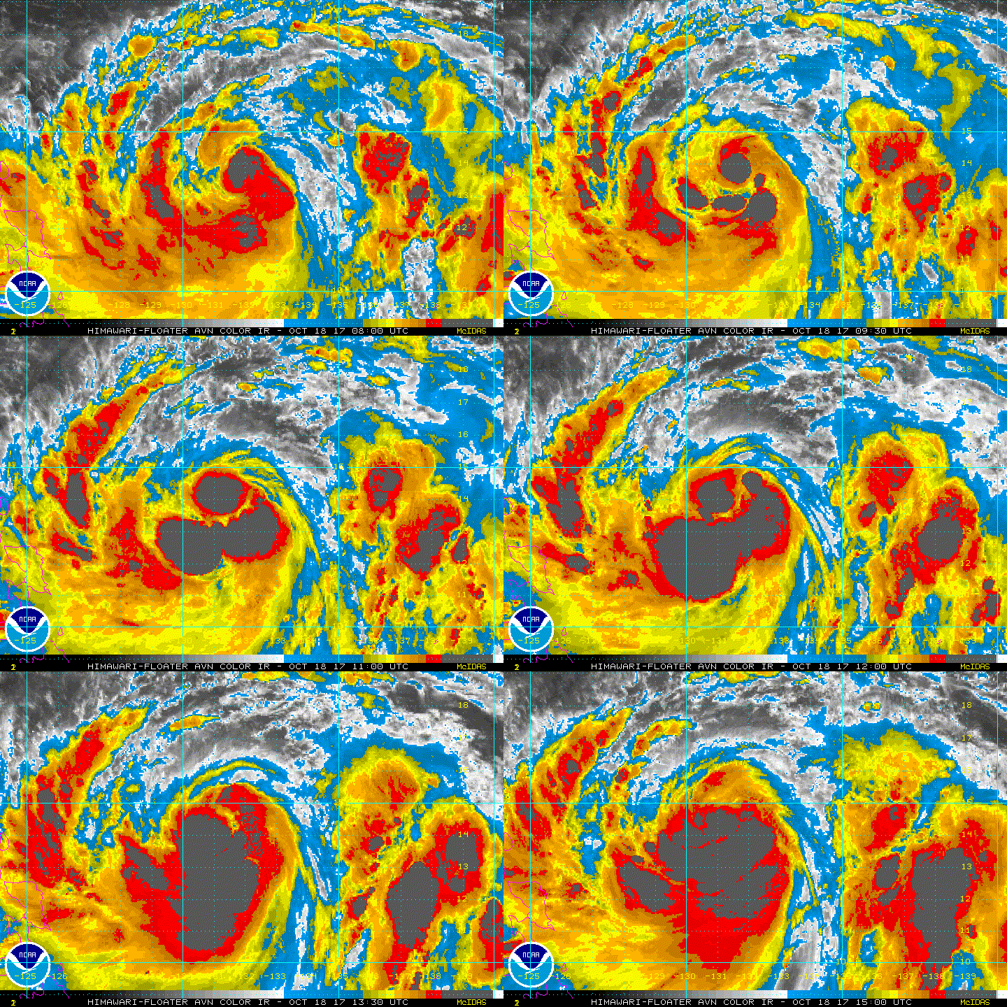
Category 5
Posts: 18547
Joined: Mon Mar 08, 2004 7:50 pm
Location: Guam

Re: WPAC: LAN - Tropical Storm

#65 Postby euro6208 » Tue Oct 17, 2017 4:08 pm

WDPN32 PGTW 172100
MSGID/GENADMIN/JOINT TYPHOON WRNCEN PEARL HARBOR HI//
SUBJ/PROGNOSTIC REASONING FOR TROPICAL STORM 25W (LAN)
WARNING NR 10//
RMKS/
1. FOR METEOROLOGISTS.
2. 6 HOUR SUMMARY AND ANALYSIS.
TROPICAL STORM (TS) 25W (LAN), LOCATED APPROXIMATELY 212 NM
NORTHWEST OF KAYANGEL, HAS TRACKED NORTH-NORTHEASTWARD AT 04 KNOTS
OVER THE PAST SIX HOURS. ANIMATED ENHANCED INFRARED SATELLITE
IMAGERY AND RECENT MICROWAVE IMAGERY DEPICT A CONSOLIDATING LOW-
LEVEL CIRCULATION CENTER (LLCC) WITH IMPROVED DEEP CONVECTIVE
BANDING WRAPPING INTO A DEFINED CENTER. THE INITIAL INTENSITY IS
ASSESSED AT 60 KNOTS BASED ON AN AVERAGE OF DVORAK INTENSITY
ESTIMATES RANGING FROM T3.5 (55 KNOTS) TO T4.0 (65 KNOTS). UPPER-
LEVEL ANALYSIS SHOWS AN EXCELLENT ENVIRONMENT WITH LOW VERTICAL WIND
SHEAR, STRONG POLEWARD OUTFLOW ENHANCED BY THE TUTT, WARM SST (30C)
AND HIGH OCEAN HEAT CONTENT VALUES. AFTER A BRIEF PERIOD OF QUASI-
STATIONARY MOTION ASSOCIATED WITH THE WEAKENING SUBTROPICAL RIDGE TO
THE NORTH, TS 25W IS TRACKING SLOWLY NORTHWARD TO NORTH-
NORTHEASTWARD UNDER THE STEERING INFLUENCE OF THE BUILDING STEERING
RIDGE TO THE SOUTHEAST AND EAST.
3. FORECAST REASONING.
A. NO CHANGE TO THE FORECAST PHILOSOPHY SINCE THE PREVIOUS
PROGNOSTIC REASONING MESSAGE. THE 34-KNOT WIND RADII HAVE BEEN
ADJUSTED LARGER BASED ON A DETAILED ANALYSIS OF A RECENT ASCAT IMAGE
SHOWING EXTENSIVE GALE-FORCE WINDS.
B. TS 25W IS FORECAST TO TRACK NORTHWARD UNDER THE STEERING
INFLUENCE OF THE BUILDING SUBTROPICAL RIDGE TO THE EAST. DESPITE THE
COMPLEX, EVOLVING SYNOPTIC STEERING PATTERN, DYNAMIC MODEL GUIDANCE
REMAINS IN TIGHT AGREEMENT WITH MINOR DIFFERENCES IN TRACK SPEED. TS
LAN IS FORECAST TO INTENSIFY STEADILY THROUGH TAU 72 TO A PEAK
INTENSITY OF 130 KNOTS DUE TO THE VERY FAVORABLE CONDITIONS.
C. IN THE EXTENDED PERIOD, TS 25W WILL WEAKEN SLIGHTLY AS THE
SYSTEM BEGINS EXTRA-TROPICAL TRANSITION (ETT) AND INTERACTS WITH
UPPER-LEVEL WESTERLIES. TS 25W WILL REMAIN A VERY LARGE SYSTEM WITH
EXTENSIVE GALE-FORCE WINDS, ENHANCED BY A COLD SURGE OVER THE RYUKYU
ISLANDS AND A STRONG BAROCLINIC SYSTEM OVER JAPAN. THE SYSTEM WILL
COMPLETE ETT JUST PRIOR TO MAKING LANDFALL OVER HONSHU BUT WILL
REMAIN A STRONG TYPHOON STRENGTH EXTRA-TROPICAL LOW. OVERALL, THERE
IS HIGH CONFIDENCE IN THE JTWC FORECAST TRACK.//
NNNN
0 likes   
Remember, all of my post aren't official. For official warnings and discussions, Please refer to your local NWS products...

NWS for the Western Pacific

https://www.weather.gov/gum/

User avatar
xtyphooncyclonex
Category 5
Category 5
Posts: 3688
Age: 22
Joined: Sat Dec 08, 2012 9:07 am
Location: Cebu City
Contact:

Re: WPAC: LAN - Tropical Storm

#66 Postby xtyphooncyclonex » Tue Oct 17, 2017 4:33 pm

17 October 2017

<Analysis at 18 UTC, 17 October>
Scale -
Intensity Strong
Center position N10°50' (10.8°)
E132°30' (132.5°)
Direction and speed of movement NE Slow
Central pressure 970 hPa
Maximum wind speed near center 35 m/s (65 kt)
Maximum wind gust speed 50 m/s (95 kt)
≥ 50 kt wind area ALL 90 km (50 NM)
≥ 30 kt wind area S 560 km (300 NM)
N 330 km (180 NM)

<Forecast for 06 UTC, 18 October>
Intensity Strong
Center position of probability circle N12°40' (12.7°)
E132°20' (132.3°)
Direction and speed of movement N 15 km/h (9 kt)
Central pressure 965 hPa
Maximum wind speed near center 35 m/s (70 kt)
Maximum wind gust speed 50 m/s (100 kt)
Radius of probability circle 60 km (30 NM)
Storm warning area ALL 170 km (90 NM)

<Forecast for 18 UTC, 18 October>
Intensity Strong
Center position of probability circle N14°35' (14.6°)
E131°35' (131.6°)
Direction and speed of movement NNW 20 km/h (10 kt)
Central pressure 950 hPa
Maximum wind speed near center 40 m/s (80 kt)
Maximum wind gust speed 60 m/s (115 kt)
Radius of probability circle 90 km (50 NM)
Storm warning area ALL 240 km (130 NM)

<Forecast for 18 UTC, 19 October>
Intensity Very strong
Center position of probability circle N17°40' (17.7°)
E130°25' (130.4°)
Direction and speed of movement NNW 15 km/h (8 kt)
Central pressure 935 hPa
Maximum wind speed near center 45 m/s (90 kt)
Maximum wind gust speed 65 m/s (130 kt)
Radius of probability circle 180 km (95 NM)
Storm warning area ALL 350 km (190 NM)

<Forecast for 18 UTC, 20 October>
Intensity Very strong
Center position of probability circle N20°40' (20.7°)
E130°30' (130.5°)
Direction and speed of movement N 15 km/h (8 kt)
Central pressure 920 hPa
Maximum wind speed near center 50 m/s (100 kt)
Maximum wind gust speed 70 m/s (140 kt)
Radius of probability circle 310 km (170 NM)
Storm warning area ALL 540 km (290 NM
0 likes   
REMINDER: My opinions that I, or any other NON Pro-Met in this forum, are unofficial. Please do not take my opinions as an official forecast and warning. I am NOT a meteorologist. Following my forecasts blindly may lead to false alarm, danger and risk if official forecasts from agencies are ignored.

User avatar
euro6208
Category 5
Category 5
Posts: 18547
Joined: Mon Mar 08, 2004 7:50 pm
Location: Guam

Re: WPAC: LAN - Typhoon

#67 Postby euro6208 » Tue Oct 17, 2017 7:19 pm

TPPN11 PGTW 172118

A. TROPICAL STORM 25W (LAN)

B. 17/2100Z

C. 11.02N

D. 132.45E

E. FIVE/HMWRI8

F. T4.0/4.0/D1.5/24HRS STT: D0.5/03HRS

G. IR/EIR

H. REMARKS: 38A/PBO SBC/ANMTN. 1.10 WRAP YIELDS A DT OF 4.0. PT
AND MET AGREE. DBO DT.

I. ADDITIONAL POSITIONS: NONE


MARTINEZ

TXPQ29 KNES 172124
TCSWNP

A. 25W (LAN)

B. 17/2030Z

C. 11.0N

D. 132.3E

E. THREE/HIMAWARI-8

F. T4.0/4.0/D1.0/24HRS

G. IR/EIR/SWIR/AMSR2

H. REMARKS...CONVECTION WRAPS 1.0 ON LOG10 SPIRAL WITH 0.5 ADDED FOR
WHITE BANDING YIELDS A DT OF 4.0. MET AND PT AGREE. FT IS BASED ON DT.

I. ADDL POSITIONS

17/1636Z 11.0N 132.5E AMSR2


...KIBLER
0 likes   
Remember, all of my post aren't official. For official warnings and discussions, Please refer to your local NWS products...

NWS for the Western Pacific

https://www.weather.gov/gum/

Sciencerocks
Category 5
Category 5
Posts: 7282
Age: 38
Joined: Thu Jul 06, 2017 1:51 am

Re: WPAC: LAN - Typhoon

#68 Postby Sciencerocks » Tue Oct 17, 2017 9:50 pm

Remains near 55 knots..Very broad "inner" core on both of the newest micowave images(22z and 23z). This thing should take another 12-18 hours to really start spinning with this mess.
0 likes   

User avatar
euro6208
Category 5
Category 5
Posts: 18547
Joined: Mon Mar 08, 2004 7:50 pm
Location: Guam

Re: WPAC: LAN - Typhoon

#69 Postby euro6208 » Tue Oct 17, 2017 11:31 pm

Upgraded to typhoon.

WDPN32 PGTW 180300
MSGID/GENADMIN/JOINT TYPHOON WRNCEN PEARL HARBOR HI//
SUBJ/PROGNOSTIC REASONING FOR TYPHOON 25W (LAN)
WARNING NR 11//
RMKS/
1. FOR METEOROLOGISTS.
2. 6 HOUR SUMMARY AND ANALYSIS.
TYPHOON (TY) 25W (LAN), LOCATED APPROXIMATELY 314 NM NORTH-
NORTHWEST OF KOROR, HAS TRACKED NORTHWARD AT 10 KNOTS OVER THE PAST
SIX HOURS. ANIMATED MULTISPECTRAL SATELLITE IMAGERY DEPICTS BROAD
DEEP CONVECTIVE BANDING WRAPPING INTO A PARTIALLY-EXPOSED LOW-LEVEL
CIRCULATION CENTER (LLCC). HOWEVER, A 172159Z SSMIS 37GHZ COLOR
IMAGE DEPICTS CONVECTIVE BANDING WRAPPING TIGHTLY INTO A WELL-
DEFINED CENTER, WHICH INDICATES A STRENGTHENING LLCC. CONSEQUENTLY,
THE INITIAL INTENSITY IS ASSESSED AT 65 KNOTS BASED ON DVORAK
INTENSITY ESTIMATES OF T4.0 FROM ALL AGENCIES. UPPER-LEVEL ANALYSIS
SHOWS AN EXCELLENT ENVIRONMENT WITH LOW VERTICAL WIND SHEAR, STRONG
POLEWARD OUTFLOW ENHANCED BY THE TUTT, WARM SST (30C) AND HIGH OCEAN
HEAT CONTENT VALUES. AFTER A BRIEF PERIOD OF QUASI-STATIONARY MOTION
ASSOCIATED WITH THE WEAKENING SUBTROPICAL RIDGE TO THE NORTH, TY 25W
CONTINUES TO TRACK NORTHWARD UNDER THE STEERING INFLUENCE OF THE
BUILDING STEERING RIDGE TO THE EAST.
3. FORECAST REASONING.
A. NO CHANGE TO THE FORECAST PHILOSOPHY SINCE THE PREVIOUS
PROGNOSTIC REASONING MESSAGE.
B. TY 25W IS FORECAST TO TRACK NORTHWARD UNDER THE STEERING
INFLUENCE OF THE BUILDING SUBTROPICAL RIDGE TO THE EAST. DESPITE THE
COMPLEX, EVOLVING SYNOPTIC STEERING PATTERN, DYNAMIC MODEL GUIDANCE
REMAINS IN TIGHT AGREEMENT WITH MINOR DIFFERENCES IN TRACK SPEED. TY
LAN IS FORECAST TO INTENSIFY STEADILY THROUGH TAU 72 TO A PEAK
INTENSITY OF 130 KNOTS DUE TO THE VERY FAVORABLE CONDITIONS.
C. IN THE EXTENDED PERIOD, TY 25W WILL WEAKEN SLIGHTLY AS THE
SYSTEM BEGINS EXTRA-TROPICAL TRANSITION (ETT) NEAR TAU 96 AND
INTERACTS WITH UPPER-LEVEL WESTERLIES. TY 25W WILL REMAIN A VERY
LARGE SYSTEM WITH EXTENSIVE GALE-FORCE WINDS, ENHANCED BY A COLD
SURGE OVER THE RYUKYU ISLANDS AND A STRONG BAROCLINIC SYSTEM OVER
JAPAN. THE SYSTEM WILL COMPLETE ETT JUST PRIOR TO MAKING LANDFALL
OVER HONSHU BUT WILL REMAIN A STRONG TYPHOON STRENGTH EXTRA-TROPICAL
LOW. OVERALL, THERE IS HIGH CONFIDENCE IN THE JTWC FORECAST TRACK.//
NNNN
0 likes   
Remember, all of my post aren't official. For official warnings and discussions, Please refer to your local NWS products...

NWS for the Western Pacific

https://www.weather.gov/gum/
User avatar
1900hurricane
Category 5
Category 5
Posts: 6044
Age: 32
Joined: Fri Feb 06, 2015 12:04 pm
Location: Houston, TX
Contact:

Re: WPAC: LAN - Typhoon

#70 Postby 1900hurricane » Wed Oct 18, 2017 12:21 am

0 likes   
Contract Meteorologist. TAMU & MSST. Fiercely authentic, one of a kind. We are all given free will, so choose a life meant to be lived. We are the Masters of our own Stories.
Opinions expressed are mine alone.

Follow me on Twitter at @1900hurricane : Read blogs at https://1900hurricane.wordpress.com/

Digital-TC-Chaser

Re: WPAC: LAN - Typhoon

#71 Postby Digital-TC-Chaser » Wed Oct 18, 2017 4:37 am

These large monsoonal type systems alway seem to take a much longer time to really start
cranking hard.
0 likes   

User avatar
1900hurricane
Category 5
Category 5
Posts: 6044
Age: 32
Joined: Fri Feb 06, 2015 12:04 pm
Location: Houston, TX
Contact:

Re: WPAC: LAN - Typhoon

#72 Postby 1900hurricane » Wed Oct 18, 2017 10:17 am

12Z upper air data indicates that 100 mb temps are colder than -85ºC in the vicinity of Lan. Potential is sky high if a core can develop, but that piece of the puzzle has been missing thus far.

Image
0 likes   
Contract Meteorologist. TAMU & MSST. Fiercely authentic, one of a kind. We are all given free will, so choose a life meant to be lived. We are the Masters of our own Stories.
Opinions expressed are mine alone.

Follow me on Twitter at @1900hurricane : Read blogs at https://1900hurricane.wordpress.com/

User avatar
mrbagyo
Category 5
Category 5
Posts: 3614
Age: 31
Joined: Thu Apr 12, 2012 9:18 am
Location: 14.13N 120.98E
Contact:

Re: WPAC: LAN - Typhoon

#73 Postby mrbagyo » Wed Oct 18, 2017 10:28 am

With its huge size and slow movement, Lan would surely send some epic ground swell all across the whole western Pacific basin. Extratropical Lan could also generate swell for the Pacific Northwest/Cascadia.

For surfers in the NE facing coast of the Philippines: NE groundswell plus Lan-enhanced offshore SW windflow means surfs up...

COASTAL HAZARD MESSAGE
NATIONAL WEATHER SERVICE TIYAN GU
415 PM CHST WED OCT 18 2017

.OVERVIEW...LARGE MONSOON SWELL AND WIND WAVES ASSOCIATED WITH
TYPHOON LAN (25W) WILL CAUSE HAZARDOUS SURF ACROSS THE REPUBLIC
OF PALAU AND YAP STATE THE NEXT SEVERAL DAYS. SURF COULD BUILD TO
DANGEROUS LEVELS ALONG SOME WEST-FACING SHORES TONIGHT.


$$

PMZ161-181900-
KOROR PALAU-
415 PM CHST WED OCT 18 2017

...HIGH SURF ADVISORY REMAINS IN EFFECT FOR SOUTH AND WEST FACING
SHORES...

HAZARDOUS SURF OF 10 TO 14 FEET WILL CONTINUE TONIGHT...POSSIBLY
BUILDING TO DANGEROUS LEVELS OF 12 TO 16 FEET AT TIMES ALONG
SOUTH AND WEST FACING SHORES. SURF WILL GRADUALLY SUBSIDE ALONG
SOUTH FACING SHORES LATE THURSDAY.

AS TYPHOON LAN MOVES FARTHER AWAY...LONG-PERIOD NORTHWEST TO
NORTH SWELL WILL REACH THE AREA AND CAUSE SURF TO INCREASE ALONG
NORTH FACING SHORES BY THE WEEKEND.

AVOID VENTURING NEAR REEF LINES AND EXPOSED BEACHES...ESPECIALLY
THOSE FACING SOUTH AND WEST...AS RIP CURRENTS WILL BE LIFE
THREATENING.

$$

COASTAL HAZARD MESSAGE
NATIONAL WEATHER SERVICE TIYAN GU
415 PM CHST WED OCT 18 2017

.OVERVIEW...LARGE MONSOON SWELL AND WIND WAVES ASSOCIATED WITH
TYPHOON LAN (25W) WILL CAUSE HAZARDOUS SURF ACROSS THE REPUBLIC
OF PALAU AND YAP STATE THE NEXT SEVERAL DAYS. SURF COULD BUILD TO
DANGEROUS LEVELS ALONG SOME WEST-FACING SHORES TONIGHT.


$$

PMZ171-181900-
YAP-
415 PM CHST WED OCT 18 2017

...HIGH SURF ADVISORY REMAINS IN EFFECT FOR SOUTH AND WEST FACING
SHORES...

HAZARDOUS SURF OF 10 TO 14 FEET WILL CONTINUE ALONG SOUTH AND
WEST FACING SHORES TONIGHT AND COULD BUILD TO DANGEROUS LEVELS OF
12 TO 16 FEET AT TIMES. SURF WILL GRADUALLY SUBSIDE ALONG SOUTH
FACING SHORES LATE THURSDAY AS THE SWELL BECOMES MORE WESTERLY.

AS TYPHOON LAN MOVES FARTHER AWAY...LONG-PERIOD NORTHWEST TO
NORTH SWELL WILL REACH THE AREA PROLONGING HAZARDOUS SURF ALONG
WEST FACING SHORES AND CAUSING SURF TO BECOME HAZARDOUS ALONG
NORTH FACING SHORES INTO THE WEEKEND.

AVOID VENTURING NEAR REEF LINES AND EXPOSED BEACHES...ESPECIALLY
THOSE FACING SOUTH AND WEST...AS RIP CURRENTS WILL BE LIFE
THREATENING.

$$

SIMPSON

COASTAL HAZARD MESSAGE
NATIONAL WEATHER SERVICE TIYAN GU
408 PM CHST WED OCT 18 2017

...SOUTHWEST MONSOON WINDS TO GENERATE HAZARDOUS SURF THIS WEEK...

.TYPHOON LAN WILL CAUSE STRONG SOUTHWEST WINDS TO DEVELOP OVER
WESTERN MICRONESIA THAT WILL GENERATE A LARGE SOUTHWEST SWELL. THESE
SWELL WILL REACH THE MARIANAS TONIGHT CAUSING SURF TO RAPIDLY BUILD
TO HAZARDOUS LEVELS.

GUZ001>004-182100-
/O.CAN.PGUM.SU.Y.0002.000000T0000Z-171022T2000Z/
/O.NEW.PGUM.SU.Y.0003.171018T0700Z-171024T0800Z/
GUAM-ROTA-TINIAN-SAIPAN-
408 PM CHST WED OCT 18 2017

...HIGH SURF ADVISORY IN EFFECT UNTIL 6 PM CHST TUESDAY...

THE NATIONAL WEATHER SERVICE IN TIYAN HAS ISSUED A HIGH SURF
ADVISORY, WHICH IS IN EFFECT UNTIL 6 PM CHST TUESDAY.

FOR SOUTH FACING REEFS...
HAZARDOUS SURF OF 7 TO 9 FT THIS EVENING WILL RISE TO BETWEEN 8
AND 11 FT EARLY THURSDAY MORNING. SURF WILL GRADUALLY SUBSIDE
ALONG SOUTH FACING REEFS LATE IN THE WEEK AS THE SOUTHWEST SWELL
BECOMES A WEST SWELL.

FOR WEST FACING REEFS...
HAZARDOUS SURF OF 7 TO 9 FT AT TINIAN AND SAIPAN AND SURF OF 6 TO
8 FT AT ROTA AND GUAM WILL BUILD TONIGHT TO BETWEEN 8 AND 11 FT BY
THURSDAY MORNING. AS SOUTHWEST TO WEST SWELL INCREASES THURSDAY...
SURF WILL BUILD TO BETWEEN 10 AND 13 FT. SURF MAY INCREASE FURTHER
OVER THE WEEKEND...POSSIBLY BECOME DANGEROUS AT 15 FT.

PRECAUTIONARY/PREPAREDNESS ACTIONS...

HIGH SURF WILL WILL PRODUCE LOCALIZED BEACH EROSION AND DANGEROUS
SWIMMING CONDITIONS. AVOID VENTURING OUT ON EXPOSED REEFS AND
BEACHES...ESPECIALLY THOSE FACING SOUTH AND WEST...AS RIP CURRENTS
WILL BE LIFE THREATENING.

A HIGH SURF ADVISORY MEANS THAT HIGH SURF WILL AFFECT BEACHES IN
THE ADVISORY AREA...PRODUCING LOCALIZED BEACH EROSION AND DANGEROUS
SWIMMING CONDITIONS.

&&

$$

AYDLETT
Last edited by mrbagyo on Wed Oct 18, 2017 10:39 am, edited 1 time in total.
0 likes   
The posts in this forum are NOT official forecast and should not be used as such. They are just the opinion of the poster and may or may not be backed by sound meteorological data. They are NOT endorsed by any professional institution or storm2k.org. For official information, please refer to RSMC, NHC and NWS products.

User avatar
xtyphooncyclonex
Category 5
Category 5
Posts: 3688
Age: 22
Joined: Sat Dec 08, 2012 9:07 am
Location: Cebu City
Contact:

Re: WPAC: LAN - Typhoon

#74 Postby xtyphooncyclonex » Wed Oct 18, 2017 10:29 am

It's increasingly likely this may not at all end up becoming a sub-900 mb system contrary to my previous prediction.... Lan is clearly struggling to rapidly consolidate, form a clear, symmetrical round eye and maintain its structure without falling apart. What sucks is that despite being hundreds of kilometers away, it has been gusty and rainy for the past several hours. Thanks, Lan... :roll: Nonetheless, it's pretty much overcast skies and downpour for us.
0 likes   
REMINDER: My opinions that I, or any other NON Pro-Met in this forum, are unofficial. Please do not take my opinions as an official forecast and warning. I am NOT a meteorologist. Following my forecasts blindly may lead to false alarm, danger and risk if official forecasts from agencies are ignored.

User avatar
1900hurricane
Category 5
Category 5
Posts: 6044
Age: 32
Joined: Fri Feb 06, 2015 12:04 pm
Location: Houston, TX
Contact:

Re: WPAC: LAN - Typhoon

#75 Postby 1900hurricane » Wed Oct 18, 2017 10:37 am

20ºN is likely the magic number. If Lan can develop a core before then, I still think a category 4 is likely. I think 48 hours will be sufficient to do so, but nothing is ever a given in tropical meteorology.
0 likes   
Contract Meteorologist. TAMU & MSST. Fiercely authentic, one of a kind. We are all given free will, so choose a life meant to be lived. We are the Masters of our own Stories.
Opinions expressed are mine alone.

Follow me on Twitter at @1900hurricane : Read blogs at https://1900hurricane.wordpress.com/

User avatar
mrbagyo
Category 5
Category 5
Posts: 3614
Age: 31
Joined: Thu Apr 12, 2012 9:18 am
Location: 14.13N 120.98E
Contact:

Re: WPAC: LAN - Typhoon

#76 Postby mrbagyo » Wed Oct 18, 2017 11:10 am

Image

Bulk of convection is still more concentrated in the southern part of the broad center of circulation.

Let's see if Lan can pull off this second core building attempt successfully

Image
0 likes   
The posts in this forum are NOT official forecast and should not be used as such. They are just the opinion of the poster and may or may not be backed by sound meteorological data. They are NOT endorsed by any professional institution or storm2k.org. For official information, please refer to RSMC, NHC and NWS products.

User avatar
1900hurricane
Category 5
Category 5
Posts: 6044
Age: 32
Joined: Fri Feb 06, 2015 12:04 pm
Location: Houston, TX
Contact:

Re: WPAC: LAN - Typhoon

#77 Postby 1900hurricane » Wed Oct 18, 2017 11:19 am

That GPM pass definitely shows the early stages of a small eyewall. Here are some more bands from the GPM pass that show it.

Image

Image

Image

Still lots of convergence focused in the parent monsoon trough on the south side of the circulation, but the recent convective blow up is directly over the eyewall feature.

Image
0 likes   
Contract Meteorologist. TAMU & MSST. Fiercely authentic, one of a kind. We are all given free will, so choose a life meant to be lived. We are the Masters of our own Stories.
Opinions expressed are mine alone.

Follow me on Twitter at @1900hurricane : Read blogs at https://1900hurricane.wordpress.com/

User avatar
mrbagyo
Category 5
Category 5
Posts: 3614
Age: 31
Joined: Thu Apr 12, 2012 9:18 am
Location: 14.13N 120.98E
Contact:

Re: WPAC: LAN - Typhoon

#78 Postby mrbagyo » Wed Oct 18, 2017 11:32 am

:uarrow: wow,i didnt realize that that was an early sign of a small eyewall forming. I thought it was just a part of the rain band.
0 likes   
The posts in this forum are NOT official forecast and should not be used as such. They are just the opinion of the poster and may or may not be backed by sound meteorological data. They are NOT endorsed by any professional institution or storm2k.org. For official information, please refer to RSMC, NHC and NWS products.

User avatar
1900hurricane
Category 5
Category 5
Posts: 6044
Age: 32
Joined: Fri Feb 06, 2015 12:04 pm
Location: Houston, TX
Contact:

Re: WPAC: LAN - Typhoon

#79 Postby 1900hurricane » Wed Oct 18, 2017 12:11 pm

It's a pretty fragile and incomplete feature. We'll see how well it holds together.
0 likes   
Contract Meteorologist. TAMU & MSST. Fiercely authentic, one of a kind. We are all given free will, so choose a life meant to be lived. We are the Masters of our own Stories.
Opinions expressed are mine alone.

Follow me on Twitter at @1900hurricane : Read blogs at https://1900hurricane.wordpress.com/

User avatar
BYG Jacob
Category 3
Category 3
Posts: 893
Age: 26
Joined: Wed Aug 23, 2017 3:46 pm
Location: Tucson, Arizona

Re: WPAC: LAN - Typhoon

#80 Postby BYG Jacob » Wed Oct 18, 2017 1:48 pm

This looks like its taking a beating from shear.
0 likes   


Return to “2017”

Who is online

Users browsing this forum: No registered users and 33 guests