WPAC: TRAMI - Post-Tropical

Moderator: S2k Moderators

Message
Author
User avatar
Highteeld
Category 5
Category 5
Posts: 2097
Age: 40
Joined: Tue Jan 30, 2018 9:10 pm
Location: Chicago

Re: WPAC: TRAMI - Typhoon

#101 Postby Highteeld » Sat Sep 22, 2018 10:29 pm

Image

Should be around a T 5.0 I reckon
0 likes   
Very useful information on the Dvorak Technique --

https://severe.worldweather.wmo.int/TCF ... kBeven.pdf

User avatar
mrbagyo
Category 5
Category 5
Posts: 3614
Age: 31
Joined: Thu Apr 12, 2012 9:18 am
Location: 14.13N 120.98E
Contact:

Re: WPAC: TRAMI - Typhoon

#102 Postby mrbagyo » Sat Sep 22, 2018 11:19 pm

:uarrow:

TCSWNP

A. 28W (TRAMI)

B. 23/0230Z

C. 17.1N

D. 134.9E

E. THREE/HIMAWARI-8

F. T5.0/5.0/D1.5/24HRS

G. IR/EIR/VIS

H. REMARKS...THIS INTENSITY ESTIMATE WAS DERIVED USING 4 KM IR DATA. CLOUD FILLED EYE IN VISIBLE LENDS HIGHER THAN USUAL CONFIDENCE IN THE DT OF 5.0 USING THE EMBEDDED CENTER PATTERN WITH A CENTER IN B. MET AND PT AGREE. FT IS BASED ON DT. I. ADDL POSITIONS NIL ...TURK
0 likes   
The posts in this forum are NOT official forecast and should not be used as such. They are just the opinion of the poster and may or may not be backed by sound meteorological data. They are NOT endorsed by any professional institution or storm2k.org. For official information, please refer to RSMC, NHC and NWS products.

User avatar
mrbagyo
Category 5
Category 5
Posts: 3614
Age: 31
Joined: Thu Apr 12, 2012 9:18 am
Location: 14.13N 120.98E
Contact:

Re: WPAC: TRAMI - Typhoon

#103 Postby mrbagyo » Sat Sep 22, 2018 11:25 pm

Image
0 likes   
The posts in this forum are NOT official forecast and should not be used as such. They are just the opinion of the poster and may or may not be backed by sound meteorological data. They are NOT endorsed by any professional institution or storm2k.org. For official information, please refer to RSMC, NHC and NWS products.

User avatar
doomhaMwx
Category 5
Category 5
Posts: 2398
Age: 25
Joined: Tue Apr 18, 2017 4:01 am
Location: Baguio/Benguet, Philippines
Contact:

Re: WPAC: TRAMI - Typhoon

#104 Postby doomhaMwx » Sun Sep 23, 2018 12:31 am

Pinhole

Image
Image
0 likes   
Like my content? Consider giving a tip.

User avatar
xtyphooncyclonex
Category 5
Category 5
Posts: 3688
Age: 22
Joined: Sat Dec 08, 2012 9:07 am
Location: Cebu City
Contact:

Re: WPAC: TRAMI - Typhoon

#105 Postby xtyphooncyclonex » Sun Sep 23, 2018 1:00 am

28W TRAMI 180923 0600 17.3N 134.2E WPAC 90 956
0 likes   
REMINDER: My opinions that I, or any other NON Pro-Met in this forum, are unofficial. Please do not take my opinions as an official forecast and warning. I am NOT a meteorologist. Following my forecasts blindly may lead to false alarm, danger and risk if official forecasts from agencies are ignored.

User avatar
mrbagyo
Category 5
Category 5
Posts: 3614
Age: 31
Joined: Thu Apr 12, 2012 9:18 am
Location: 14.13N 120.98E
Contact:

Re: WPAC: TRAMI - Typhoon

#106 Postby mrbagyo » Sun Sep 23, 2018 2:31 am

TY 1824 (Trami)
Issued at 06:45 UTC, 23 September 2018

<Analysis at 06 UTC, 23 September>
Scale -
Intensity Strong
Center position N17°20' (17.3°)
E134°20' (134.3°)
Direction and speed of movement W 15 km/h (9 kt)
Central pressure 970 hPa
Maximum wind speed near center 35 m/s (70 kt)
Maximum wind gust speed 50 m/s (100 kt)
≥ 50 kt wind area ALL 90 km (50 NM)
≥ 30 kt wind area NE 390 km (210 NM)
SW 220 km (120 NM)
0 likes   
The posts in this forum are NOT official forecast and should not be used as such. They are just the opinion of the poster and may or may not be backed by sound meteorological data. They are NOT endorsed by any professional institution or storm2k.org. For official information, please refer to RSMC, NHC and NWS products.

User avatar
euro6208
Category 5
Category 5
Posts: 18547
Joined: Mon Mar 08, 2004 7:50 pm
Location: Guam

Re: WPAC: TRAMI - Typhoon

#107 Postby euro6208 » Sun Sep 23, 2018 3:55 am

Image

WDPN31 PGTW 230900
MSGID/GENADMIN/JOINT TYPHOON WRNCEN PEARL HARBOR HI//
SUBJ/PROGNOSTIC REASONING FOR TYPHOON 28W (TRAMI)
WARNING NR 11//
RMKS//
1. FOR METEOROLOGISTS.
2. 6 HOUR SUMMARY AND ANALYSIS.
TYPHOON (TY) 28W (TRAMI), LOCATED APPROXIMATELY 660 NM SOUTHEAST
OF KADENA AB, OKINAWA, JAPAN, HAS TRACKED WEST-NORTHWESTWARD AT 09
KNOTS OVER THE PAST SIX HOURS. ANIMATED ENHANCED INFRARED SATELLITE
IMAGERY DEPICTS A 130NM DIAMETER CENTRAL DENSE OVERCAST FEATURE WITH
A 10NM RAGGED EYE. A 230438Z AMSR2 89GHZ IMAGE INDICATES A RAPIDLY
CONSOLIDATING SYSTEM WITH SPIRAL BANDING WRAPPING INTO A COMPACT
EYEWALL AND MICROWAVE EYE FEATURE, WHICH SUPPORTS THE CURRENT
POSITION WITH HIGH CONFIDENCE. TY TRAMI HAS RAPIDLY INTENSIFIED 45
KNOTS OVER THE PAST 24 HOURS FROM 50 KNOTS TO THE CURRENT INTENSITY
OF 95 KNOTS, WHICH IS BASED ON AN AVERAGE OF DVORAK ESTIMATES
RANGING FROM T5.0 (90 KNOTS) TO T5.5 (102 KNOTS). UPPER-LEVEL
ANALYSIS INDICATES A FAVORABLE ENVIRONMENT WITH NEAR-RADIAL
OUTFLOW, ENHANCED BY A TUTT CELL TO THE NORTHEAST, AND LOW VERTICAL
WIND SHEAR. TY 28W IS TRACKING WEST-NORTHWESTWARD ALONG THE SOUTHERN
PERIPHERY OF A DEEP-LAYERED SUBTROPICAL RIDGE (STR) ENTRENCHED TO
THE NORTH.
3. FORECAST REASONING.
A. THERE IS NO CHANGE TO THE FORECAST PHILOSOPHY SINCE THE
PREVIOUS PROGNOSTIC REASONING MESSAGE. THE INITIAL 34-KNOT WIND
RADII HAVE BEEN ADJUSTED BASED ON A DETAILED ANALYSIS OF THE 230017Z
ASCAT IMAGE.
B. TS TRAMI IS FORECAST TO TRACK WEST-NORTHWESTWARD UNDER THE
STEERING INFLUENCE OF THE AFOREMENTIONED STR THROUGH TAU 36. AFTER
TAU 36, A MIDLATITUDE SHORTWAVE TROUGH WILL DEEPEN OVER
THE EAST CHINA SEA AND WESTERN JAPAN CREATING A BROAD, PERSISTENT
BREAK IN THE STR. THIS WILL RESULT IN A SLIGHT POLEWARD TURN AND
SIGNIFICANT DECREASE IN TRACK SPEEDS AS THE STEERING INFLUENCE
ERODES QUICKLY. TRACK SPEEDS ARE EXPECTED TO REMAIN SLOW THROUGH TAU
72 AS THE STR SLOWLY REBUILDS TO THE NORTH AND THE SYSTEM RETURNS TO
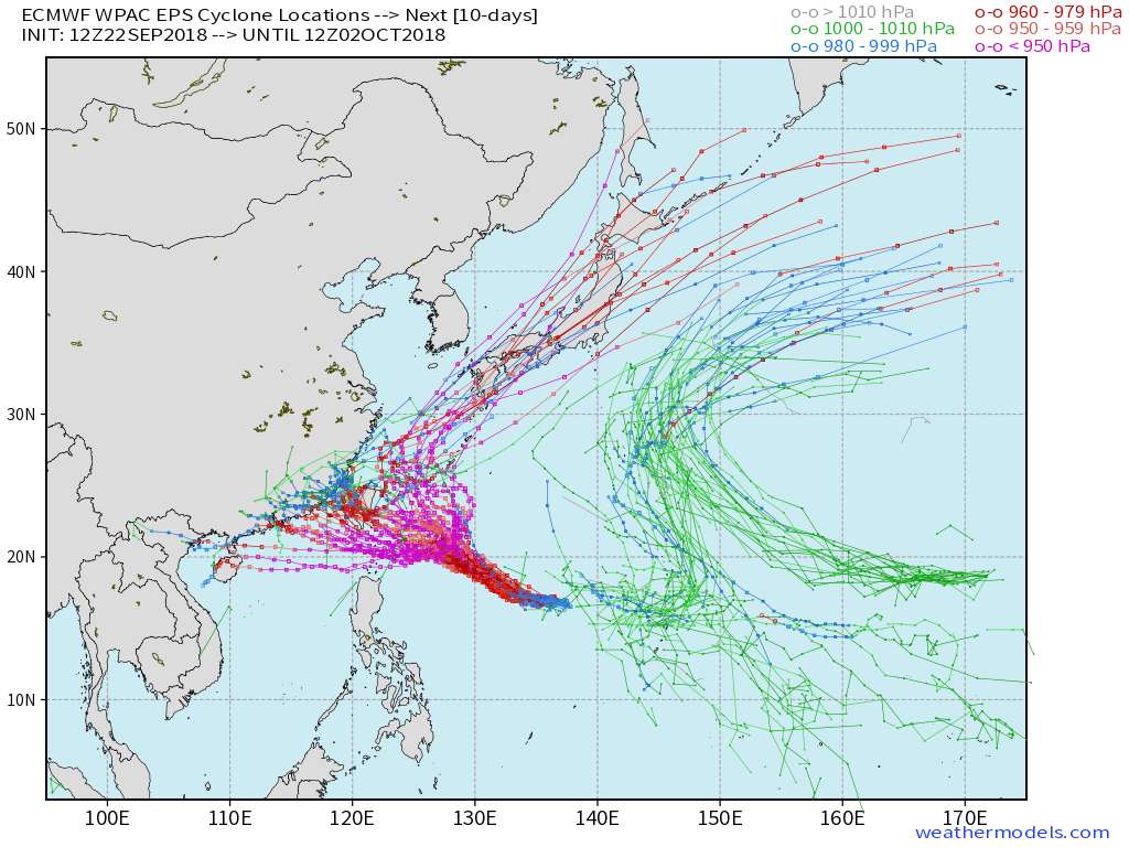
A WEST-NORTHWESTWARD COURSE. WITH THE EXCEPTION OF HWRF AND GFS,
NUMERICAL MODEL GUIDANCE REMAINS IN GOOD AGREEMENT WITH A 120NM
SPREAD IN SOLUTIONS AT TAU 72, HOWEVER, THERE IS SIGNIFICANT
UNCERTAINTY IN THE TRACK / TRACK SPEEDS DURING THE TAU 48 TO TAU 72
PERIOD WITH AN ERRATIC TRACK POSSIBLE. THE SYSTEM IS EXPECTED TO
INTENSIFY TO SUPER TYPHOON STRENGTH BY TAU 36 UNDER VERY FAVORABLE
CONDITIONS WITH A PEAK INTENSITY OF 140 KNOTS ANTICIPATED BY TAU 72.
C. AFTER TAU 72, NUMERICAL MODEL GUIDANCE INDICATES INCREASING
SPREAD AND GREATER UNCERTAINTY IN THE EXACT FORECAST TRACK WITH A
330NM SPREAD IN SOLUTIONS AT TAU 120 (EXCLUDING THE HWRF AND GFS
OUTLIERS). THE GFS AND HWRF SOLUTIONS SHOW A SHARP NORTHWARD TRACK
TOWARD THE RYUKYU ISLANDS IN THE EXTENDED PERIOD WHICH IS DEEMED
UNLIKELY DUE TO EXCESSIVE INTERACTION WITH THE MIDLATITUDE SHORTWAVE
TROUGH. THE JTWC OFFICIAL FORECAST FAVORS A SLOW, WEST-NORTHWESTWARD
TRACK TOWARD TAIWAN AND ISHIGAKI-JIMA AS SUPPORTED BY THE BULK OF
THE MODEL GUIDANCE. TY 28W IS FORECAST TO WEAKEN SLIGHTLY AFTER TAU
72 AS ENVIRONMENTAL CONDITIONS DEGRADE. OVERALL, THERE IS LOW
CONFIDENCE IN THE JTWC TRACK DUE TO THE LARGE SPREAD IN SOLUTIONS
AFTER TAU 72.//
NNNN
0 likes   
Remember, all of my post aren't official. For official warnings and discussions, Please refer to your local NWS products...

NWS for the Western Pacific

https://www.weather.gov/gum/

User avatar
euro6208
Category 5
Category 5
Posts: 18547
Joined: Mon Mar 08, 2004 7:50 pm
Location: Guam

Re: WPAC: TRAMI - Typhoon

#108 Postby euro6208 » Sun Sep 23, 2018 4:25 am

UW - CIMSS
ADVANCED DVORAK TECHNIQUE
ADT-Version 9.0
Tropical Cyclone Intensity Algorithm

----- Current Analysis -----
Date : 23 SEP 2018 Time : 084000 UTC
Lat : 17:28:47 N Lon : 133:45:00 E


CI# /Pressure/ Vmax
4.5 / 974.2mb/ 77.0kt


Final T# Adj T# Raw T#
4.5 4.5 6.2

Estimated radius of max. wind based on IR :<10 km

Center Temp : -23.4C Cloud Region Temp : -75.1C

Scene Type : PINHOLE EYE

Subtropical Adjustment : OFF

Extratropical Adjustment : OFF

Positioning Method : ARCHER POSITIONING

Ocean Basin : WEST PACIFIC
Dvorak CI > MSLP Conversion Used : CKZ Method

Tno/CI Rules : Constraint Limits : MW ON
Weakening Flag : OFF
Rapid Dissipation Flag : OFF

C/K/Z MSLP Estimate Inputs :
- Average 34 knot radii : 113nmi
- Environmental MSLP : 1007mb

Satellite Name : HIM-8
Satellite Viewing Angle : 22.0 degrees

****************************************************
0 likes   
Remember, all of my post aren't official. For official warnings and discussions, Please refer to your local NWS products...

NWS for the Western Pacific

https://www.weather.gov/gum/

User avatar
TorSkk
Category 2
Category 2
Posts: 514
Joined: Thu Jul 05, 2018 5:08 am

Re: WPAC: TRAMI - Typhoon

#109 Postby TorSkk » Sun Sep 23, 2018 4:26 am

Intensifying rapidly

Image
0 likes   

User avatar
doomhaMwx
Category 5
Category 5
Posts: 2398
Age: 25
Joined: Tue Apr 18, 2017 4:01 am
Location: Baguio/Benguet, Philippines
Contact:

Re: WPAC: TRAMI - Typhoon

#110 Postby doomhaMwx » Sun Sep 23, 2018 4:55 am

Image
0 likes   
Like my content? Consider giving a tip.

User avatar
mrbagyo
Category 5
Category 5
Posts: 3614
Age: 31
Joined: Thu Apr 12, 2012 9:18 am
Location: 14.13N 120.98E
Contact:

Re: WPAC: TRAMI - Typhoon

#111 Postby mrbagyo » Sun Sep 23, 2018 5:27 am

Image

Eyewall Replacement Cycle is underway
0 likes   
The posts in this forum are NOT official forecast and should not be used as such. They are just the opinion of the poster and may or may not be backed by sound meteorological data. They are NOT endorsed by any professional institution or storm2k.org. For official information, please refer to RSMC, NHC and NWS products.

User avatar
doomhaMwx
Category 5
Category 5
Posts: 2398
Age: 25
Joined: Tue Apr 18, 2017 4:01 am
Location: Baguio/Benguet, Philippines
Contact:

Re: WPAC: TRAMI - Typhoon

#112 Postby doomhaMwx » Sun Sep 23, 2018 5:30 am

Image
0 likes   
Like my content? Consider giving a tip.

NotoSans
Category 5
Category 5
Posts: 1366
Age: 24
Joined: Sun Sep 27, 2015 1:15 am
Location: Hong Kong
Contact:

Re: WPAC: TRAMI - Typhoon

#113 Postby NotoSans » Sun Sep 23, 2018 6:12 am

Eye has already become cloud-filled, consistent with the ERC revealed by microwave imagery a few hours ago. Instantaneous DT reached 7.0 at around 10Z but that's certainly short-lived.
0 likes   
Personal Forecast Disclaimer:
The posts in this forum are NOT official forecast and should not be used as such. They are just the opinion of the poster and may or may not be backed by sound meteorological data. They are NOT endorsed by any professional institution or storm2k.org. For official information, please refer to RSMC and NWS products.

User avatar
doomhaMwx
Category 5
Category 5
Posts: 2398
Age: 25
Joined: Tue Apr 18, 2017 4:01 am
Location: Baguio/Benguet, Philippines
Contact:

Re: WPAC: TRAMI - Typhoon

#114 Postby doomhaMwx » Sun Sep 23, 2018 6:27 am

JTWC 115kts for 12Z.

28W TRAMI 180923 1200 17.4N 133.2E WPAC 115 937
0 likes   
Like my content? Consider giving a tip.

User avatar
euro6208
Category 5
Category 5
Posts: 18547
Joined: Mon Mar 08, 2004 7:50 pm
Location: Guam

Re: WPAC: TRAMI - Typhoon

#115 Postby euro6208 » Sun Sep 23, 2018 7:07 am

A cat 4.

Glad JTWC went up as dvorak can underestimate the intensity big time.
0 likes   
Remember, all of my post aren't official. For official warnings and discussions, Please refer to your local NWS products...

NWS for the Western Pacific

https://www.weather.gov/gum/

User avatar
xtyphooncyclonex
Category 5
Category 5
Posts: 3688
Age: 22
Joined: Sat Dec 08, 2012 9:07 am
Location: Cebu City
Contact:

Re: WPAC: TRAMI - Typhoon

#116 Postby xtyphooncyclonex » Sun Sep 23, 2018 7:20 am

Accounting for the wind lag and constraints, any estimate from 105-115 kts seems reasonable. Some weakening may occur, but it may be negligible. The subsequent intensification could be much more dramatic than the opposite. A powerful monster in the making.
0 likes   
REMINDER: My opinions that I, or any other NON Pro-Met in this forum, are unofficial. Please do not take my opinions as an official forecast and warning. I am NOT a meteorologist. Following my forecasts blindly may lead to false alarm, danger and risk if official forecasts from agencies are ignored.

User avatar
euro6208
Category 5
Category 5
Posts: 18547
Joined: Mon Mar 08, 2004 7:50 pm
Location: Guam

Re: WPAC: TRAMI - Typhoon

#117 Postby euro6208 » Sun Sep 23, 2018 7:39 am

TPPN10 PGTW 231201

A. TYPHOON 28W (TRAMI)

B. 23/1140Z

C. 17.44N

D. 133.36E

E. THREE/HMWRI8

F. T6.0/6.0/D2.5/24HRS STT: D0.5/03HRS

G. IR/EIR

H. REMARKS: 09A/PBO RAGGED EYE/ANMTN. LG EYE SURROUNDED BY W
YIELDS AN E# AND DT (NO EYE ADJUSTMENT) OF 6.0. MET YIELDS 5.0,
WHILE PT YIELDS 6.0. DBO DT.

I. ADDITIONAL POSITIONS:
23/0848Z 17.45N 133.78E SSMS
23/0925Z 17.45N 133.62E SSMS


LOWE
0 likes   
Remember, all of my post aren't official. For official warnings and discussions, Please refer to your local NWS products...

NWS for the Western Pacific

https://www.weather.gov/gum/

User avatar
euro6208
Category 5
Category 5
Posts: 18547
Joined: Mon Mar 08, 2004 7:50 pm
Location: Guam

Re: WPAC: TRAMI - Typhoon

#118 Postby euro6208 » Sun Sep 23, 2018 7:42 am

Wow.

Image
Image
0 likes   
Remember, all of my post aren't official. For official warnings and discussions, Please refer to your local NWS products...

NWS for the Western Pacific

https://www.weather.gov/gum/

User avatar
euro6208
Category 5
Category 5
Posts: 18547
Joined: Mon Mar 08, 2004 7:50 pm
Location: Guam

Re: WPAC: TRAMI - Typhoon

#119 Postby euro6208 » Sun Sep 23, 2018 7:46 am

CURRENT ESTIMATE
Date (mmddhhmm): 09230925
SATCON: MSLP = 944 hPa MSW = 110 knots
SATCON Member Consensus: 104.0 knots
Pressure -> Wind Using SATCON MSLP: 115 knots
Distance to Outer Closed Isobar Used is 200 nm
Eye Size Correction Used is 8.4 knots Source: IR

Member Estimates

ADT: 955 hPa 102 knots Scene: CDO Date: SEP231140
CIMSS AMSU: 966 hPa 94 knots Bias Corr: 0 (MW) Date: 09222316
ATMS: 962.4 hPa 89.2 knots Date: 09230440
SSMIS: 934.0 hPa 106.0 knots Date: 09230925
CIRA ATMS: 963 hPa 88 knots Date: 09230351
0 likes   
Remember, all of my post aren't official. For official warnings and discussions, Please refer to your local NWS products...

NWS for the Western Pacific

https://www.weather.gov/gum/

User avatar
euro6208
Category 5
Category 5
Posts: 18547
Joined: Mon Mar 08, 2004 7:50 pm
Location: Guam

Re: WPAC: TRAMI - Typhoon

#120 Postby euro6208 » Sun Sep 23, 2018 7:50 am

0 likes   
Remember, all of my post aren't official. For official warnings and discussions, Please refer to your local NWS products...

NWS for the Western Pacific

https://www.weather.gov/gum/


Return to “2018”

Who is online

Users browsing this forum: No registered users and 96 guests