


WPAC: TRAMI - Post-Tropical
Moderator: S2k Moderators
-
doomhaMwx

- Category 5

- Posts: 2398
- Age: 25
- Joined: Tue Apr 18, 2017 4:01 am
- Location: Baguio/Benguet, Philippines
- Contact:


Re: WPAC: TRAMI - Typhoon
WDPN31 PGTW 240900
MSGID/GENADMIN/JOINT TYPHOON WRNCEN PEARL HARBOR HI//
SUBJ/PROGNOSTIC REASONING FOR SUPER TYPHOON 28W (TRAMI)
WARNING NR 15//
RMKS//
1. FOR METEOROLOGISTS.
2. 6 HOUR SUMMARY AND ANALYSIS.
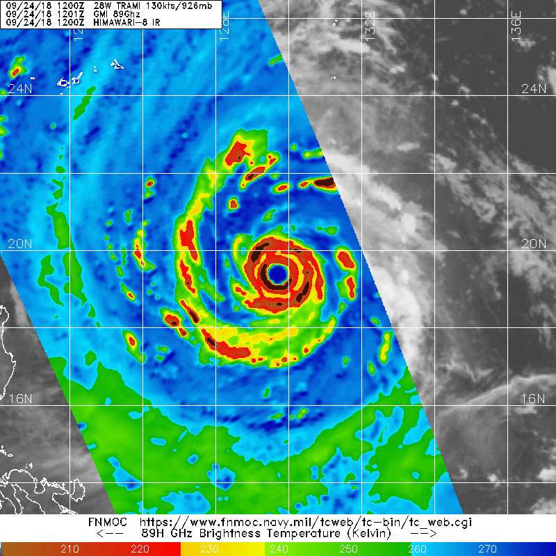
SUPER TYPHOON (STY) 28W (TRAMI), LOCATED APPROXIMATELY 478 NM
SOUTH-SOUTHEAST OF KADENA AB, OKINAWA, JAPAN, HAS TRACKED
NORTHWESTWARD AT 08 KNOTS OVER THE PAST SIX HOURS. ANIMATED ENHANCED
INFRARED (EIR) SATELLITE IMAGERY DEPICTS A SYMMETRIC EYEWALL
SURROUNDING A 30NM ROUND EYE. A 240558Z SSMI 85GHZ IMAGE REVEALS
EXCELLENT SPIRAL BANDING WRAPPING INTO A 110NM DIAMETER CORE.
CONSEQUENTLY, THERE IS HIGH CONFIDENCE IN THE CURRENT POSITION. STY
28W HAS RAPIDLY INTENSIFIED (35 KNOTS) OVER THE PAST 24 HOURS FROM
95 KNOTS TO THE CURRENT INTENSITY OF 130 KNOTS, WHICH IS BASED ON
PGTW/RJTD DVORAK INTENSITY ESTIMATES OF T6.5 (127 KNOTS). RECENT EIR
BRIEFLY INDICATED DVORAK INTENSITY ESTIMATES OF T7.0. THEREFORE, THE
CURRENT INTENSITY IS HEDGED ABOVE THE DVORAK INTENSITY ESTIMATES AT
SUPER TYPHOON STRENGTH. DESPITE WEAKENING OUTFLOW INTO A TUTT CELL
POSITIONED TO THE EAST, UPPER-LEVEL OUTFLOW REMAINS ROBUST WITH A
STRONG POLEWARD CHANNEL ASSOCIATED WITH A DEEP UPPER-LEVEL SHORTWAVE
TROUGH OVER THE EAST CHINA SEA. STY 28W IS TRACKING NORTHWESTWARD
ALONG THE SOUTHWESTERN PERIPHERY OF A DEEP-LAYERED SUBTROPICAL RIDGE
(STR) ENTRENCHED TO THE NORTH.
3. FORECAST REASONING.
A. THERE IS NO CHANGE TO THE FORECAST PHILOSOPHY SINCE THE
PREVIOUS PROGNOSTIC REASONING MESSAGE.
B. STY TRAMI IS FORECAST TO TRACK WEST-NORTHWESTWARD UNDER THE
STEERING INFLUENCE OF THE AFOREMENTIONED STR THROUGH TAU 12. AFTER
TAU 12, THE MIDLATITUDE SHORTWAVE TROUGH WILL DEEPEN OVER THE EAST
CHINA SEA AND WESTERN JAPAN CREATING A BROAD, PERSISTENT BREAK IN
THE STR. THIS WILL RESULT IN A SLIGHT POLEWARD TURN AND SIGNIFICANT
DECREASE IN TRACK SPEEDS AS THE STEERING INFLUENCE ERODES QUICKLY.
TRACK SPEEDS ARE EXPECTED TO REMAIN SLOW THROUGH TAU 72 AS THE STR
SLOWLY REBUILDS TO THE NORTH AND THE SYSTEM RETURNS TO A
NORTHWESTWARD COURSE. NUMERICAL MODEL GUIDANCE REMAINS IN MARGINAL
AGREEMENT THROUGH TAU 72 WITH A 140NM SPREAD IN SOLUTIONS AT TAU 72,
HOWEVER, TRACKERS VARY FROM A WEST-NORTHWESTWARD TRACK TO A NORTH-
NORTHEASTWARD TRACK. CONSEQUENTLY, THERE IS SIGNIFICANT UNCERTAINTY
IN THE TRACK / TRACK SPEEDS DURING THE TAU 12 TO TAU 72 PERIOD WITH
AN ERRATIC TRACK POSSIBLE. THE SYSTEM IS EXPECTED TO MAINTAIN SUPER
TYPHOON STRENGTH THROUGH TAU 72 WITH A PEAK INTENSITY OF 145 KNOTS
ANTICIPATED BY TAU 24.
C. AFTER TAU 72, NUMERICAL MODEL GUIDANCE INDICATES INCREASING
SPREAD AND GREATER UNCERTAINTY IN THE EXACT FORECAST TRACK WITH A
510NM SPREAD IN SOLUTIONS AT TAU 120. IN GENERAL, THE GLOBAL MODELS
DEPICT A SIMILAR SYNOPTIC ENVIRONMENT WITH A WEAK EXTENSION OF THE
STR TO THE NORTH SUPPORTED BY A MIDLATITUDE SHORTWAVE RIDGE,
HOWEVER, EACH MODEL INDICATES SIGNIFICANTLY DIFFERENT TRACK
FORECASTS FROM TAIWAN TO OKINAWA. THE JTWC OFFICIAL FORECAST FAVORS
A NORTHWESTWARD TRACK TOWARD ISHIGAKI-JIMA AS SUPPORTED BY THE MULTI-
MODEL CONSENSUS. STY 28W IS FORECAST TO WEAKEN SLIGHTLY AFTER TAU 72
AS ENVIRONMENTAL CONDITIONS DEGRADE. OVERALL, THERE IS LOW
CONFIDENCE IN THE JTWC TRACK DUE TO THE LARGE DEGREE OF UNCERTAINTY
THROUGH THE ENTIRE FORECAST TRACK.//
NNNN
MSGID/GENADMIN/JOINT TYPHOON WRNCEN PEARL HARBOR HI//
SUBJ/PROGNOSTIC REASONING FOR SUPER TYPHOON 28W (TRAMI)
WARNING NR 15//
RMKS//
1. FOR METEOROLOGISTS.
2. 6 HOUR SUMMARY AND ANALYSIS.
SUPER TYPHOON (STY) 28W (TRAMI), LOCATED APPROXIMATELY 478 NM
SOUTH-SOUTHEAST OF KADENA AB, OKINAWA, JAPAN, HAS TRACKED
NORTHWESTWARD AT 08 KNOTS OVER THE PAST SIX HOURS. ANIMATED ENHANCED
INFRARED (EIR) SATELLITE IMAGERY DEPICTS A SYMMETRIC EYEWALL
SURROUNDING A 30NM ROUND EYE. A 240558Z SSMI 85GHZ IMAGE REVEALS
EXCELLENT SPIRAL BANDING WRAPPING INTO A 110NM DIAMETER CORE.
CONSEQUENTLY, THERE IS HIGH CONFIDENCE IN THE CURRENT POSITION. STY
28W HAS RAPIDLY INTENSIFIED (35 KNOTS) OVER THE PAST 24 HOURS FROM
95 KNOTS TO THE CURRENT INTENSITY OF 130 KNOTS, WHICH IS BASED ON
PGTW/RJTD DVORAK INTENSITY ESTIMATES OF T6.5 (127 KNOTS). RECENT EIR
BRIEFLY INDICATED DVORAK INTENSITY ESTIMATES OF T7.0. THEREFORE, THE
CURRENT INTENSITY IS HEDGED ABOVE THE DVORAK INTENSITY ESTIMATES AT
SUPER TYPHOON STRENGTH. DESPITE WEAKENING OUTFLOW INTO A TUTT CELL
POSITIONED TO THE EAST, UPPER-LEVEL OUTFLOW REMAINS ROBUST WITH A
STRONG POLEWARD CHANNEL ASSOCIATED WITH A DEEP UPPER-LEVEL SHORTWAVE
TROUGH OVER THE EAST CHINA SEA. STY 28W IS TRACKING NORTHWESTWARD
ALONG THE SOUTHWESTERN PERIPHERY OF A DEEP-LAYERED SUBTROPICAL RIDGE
(STR) ENTRENCHED TO THE NORTH.
3. FORECAST REASONING.
A. THERE IS NO CHANGE TO THE FORECAST PHILOSOPHY SINCE THE
PREVIOUS PROGNOSTIC REASONING MESSAGE.
B. STY TRAMI IS FORECAST TO TRACK WEST-NORTHWESTWARD UNDER THE
STEERING INFLUENCE OF THE AFOREMENTIONED STR THROUGH TAU 12. AFTER
TAU 12, THE MIDLATITUDE SHORTWAVE TROUGH WILL DEEPEN OVER THE EAST
CHINA SEA AND WESTERN JAPAN CREATING A BROAD, PERSISTENT BREAK IN
THE STR. THIS WILL RESULT IN A SLIGHT POLEWARD TURN AND SIGNIFICANT
DECREASE IN TRACK SPEEDS AS THE STEERING INFLUENCE ERODES QUICKLY.
TRACK SPEEDS ARE EXPECTED TO REMAIN SLOW THROUGH TAU 72 AS THE STR
SLOWLY REBUILDS TO THE NORTH AND THE SYSTEM RETURNS TO A
NORTHWESTWARD COURSE. NUMERICAL MODEL GUIDANCE REMAINS IN MARGINAL
AGREEMENT THROUGH TAU 72 WITH A 140NM SPREAD IN SOLUTIONS AT TAU 72,
HOWEVER, TRACKERS VARY FROM A WEST-NORTHWESTWARD TRACK TO A NORTH-
NORTHEASTWARD TRACK. CONSEQUENTLY, THERE IS SIGNIFICANT UNCERTAINTY
IN THE TRACK / TRACK SPEEDS DURING THE TAU 12 TO TAU 72 PERIOD WITH
AN ERRATIC TRACK POSSIBLE. THE SYSTEM IS EXPECTED TO MAINTAIN SUPER
TYPHOON STRENGTH THROUGH TAU 72 WITH A PEAK INTENSITY OF 145 KNOTS
ANTICIPATED BY TAU 24.
C. AFTER TAU 72, NUMERICAL MODEL GUIDANCE INDICATES INCREASING
SPREAD AND GREATER UNCERTAINTY IN THE EXACT FORECAST TRACK WITH A
510NM SPREAD IN SOLUTIONS AT TAU 120. IN GENERAL, THE GLOBAL MODELS
DEPICT A SIMILAR SYNOPTIC ENVIRONMENT WITH A WEAK EXTENSION OF THE
STR TO THE NORTH SUPPORTED BY A MIDLATITUDE SHORTWAVE RIDGE,
HOWEVER, EACH MODEL INDICATES SIGNIFICANTLY DIFFERENT TRACK
FORECASTS FROM TAIWAN TO OKINAWA. THE JTWC OFFICIAL FORECAST FAVORS
A NORTHWESTWARD TRACK TOWARD ISHIGAKI-JIMA AS SUPPORTED BY THE MULTI-
MODEL CONSENSUS. STY 28W IS FORECAST TO WEAKEN SLIGHTLY AFTER TAU 72
AS ENVIRONMENTAL CONDITIONS DEGRADE. OVERALL, THERE IS LOW
CONFIDENCE IN THE JTWC TRACK DUE TO THE LARGE DEGREE OF UNCERTAINTY
THROUGH THE ENTIRE FORECAST TRACK.//
NNNN
0 likes
Remember, all of my post aren't official. For official warnings and discussions, Please refer to your local NWS products...
NWS for the Western Pacific
https://www.weather.gov/gum/
NWS for the Western Pacific
https://www.weather.gov/gum/
-
doomhaMwx
- Category 5
- Posts: 2398
- Age: 25
- Joined: Tue Apr 18, 2017 4:01 am
- Location: Baguio/Benguet, Philippines
- Contact:
Re: WPAC: TRAMI - Typhoon
Uncertainty remains, but in the last 24hrs or so, the spread in the model guidance has decreased, now just confined to Taiwan and the Ryukyu islands.
0 likes
Like my content? Consider giving a tip.
Re: WPAC: TRAMI - Typhoon
This is a Cat 5. Guesstimates are useless. Too bad no more recon.


2 likes
Remember, all of my post aren't official. For official warnings and discussions, Please refer to your local NWS products...
NWS for the Western Pacific
https://www.weather.gov/gum/
NWS for the Western Pacific
https://www.weather.gov/gum/
Re: WPAC: TRAMI - Typhoon
EURO has Okinawa right in the eye of Trami. GFS a bit west.
0 likes
Remember, all of my post aren't official. For official warnings and discussions, Please refer to your local NWS products...
NWS for the Western Pacific
https://www.weather.gov/gum/
NWS for the Western Pacific
https://www.weather.gov/gum/

Re: WPAC: TRAMI - Typhoon
2018SEP24 104000 6.4 930.8 124.6 6.3 6.8 6.8 NO LIMIT ON OFF OFF OFF 18.60 -73.62 EYE 33 IR 72.4 19.29 -129.83 ARCHER HIM-8 25.8
2018SEP24 111000 6.4 930.8 124.6 6.3 6.2 6.2 NO LIMIT ON OFF OFF OFF 18.15 -72.99 EYE/L 34 IR 59.1 19.32 -129.75 ARCHER HIM-8 25.8
ADT switching to EYE/L which makes estimates even lower
2018SEP24 111000 6.4 930.8 124.6 6.3 6.2 6.2 NO LIMIT ON OFF OFF OFF 18.15 -72.99 EYE/L 34 IR 59.1 19.32 -129.75 ARCHER HIM-8 25.8
ADT switching to EYE/L which makes estimates even lower
0 likes
ヤンデレ女が寝取られるているのを見たい!!!
ECMWF ensemble NWPAC plots: https://ecmwfensnwpac.imgbb.com/
Multimodel NWPAC plots: https://multimodelnwpac.imgbb.com/
GFS Ensemble NWPAC plots (16 & 35 day forecast): https://gefsnwpac.imgbb.com/
Plots updated automatically
ECMWF ensemble NWPAC plots: https://ecmwfensnwpac.imgbb.com/
Multimodel NWPAC plots: https://multimodelnwpac.imgbb.com/
GFS Ensemble NWPAC plots (16 & 35 day forecast): https://gefsnwpac.imgbb.com/
Plots updated automatically
Re: WPAC: TRAMI - Typhoon
CIMSS TROPICAL CYCLONE INTENSITY CONSENSUS FOR TRAMI (28W) 2018
CURRENT ESTIMATE
Date (mmddhhmm): 09241001
SATCON: MSLP = 918 hPa MSW = 136 knots
SATCON Member Consensus: 132.0 knots
Pressure -> Wind Using SATCON MSLP: 124 knots
Distance to Outer Closed Isobar Used is 205 nm
Eye Size Correction Used is -3.1 knots Source: IR
Member Estimates
ADT: 931 hPa 125 knots Scene: CDO Date: SEP241110
CIMSS AMSU: 910 hPa 141 knots Bias Corr: 0 (MW) Date: 09241001
ATMS: 913.6 hPa 141.2 knots Date: 09240422
SSMIS: 913.6 hPa 141.2 knots Date: 09240422
CIRA ATMS: 939 hPa 117 knots Date:
0 likes
ヤンデレ女が寝取られるているのを見たい!!!
ECMWF ensemble NWPAC plots: https://ecmwfensnwpac.imgbb.com/
Multimodel NWPAC plots: https://multimodelnwpac.imgbb.com/
GFS Ensemble NWPAC plots (16 & 35 day forecast): https://gefsnwpac.imgbb.com/
Plots updated automatically
ECMWF ensemble NWPAC plots: https://ecmwfensnwpac.imgbb.com/
Multimodel NWPAC plots: https://multimodelnwpac.imgbb.com/
GFS Ensemble NWPAC plots (16 & 35 day forecast): https://gefsnwpac.imgbb.com/
Plots updated automatically
Re: WPAC: TRAMI - Typhoon
TPPN10 PGTW 241223
A. SUPER TYPHOON 28W (TRAMI)
B. 24/1150Z
C. 19.28N
D. 129.75E
E. THREE/HMWRI8
F. T6.5/6.5/D0.5/24HRS STT: S0.0/03HRS
G. IR/EIR
H. REMARKS: 09A/PBO RAGGED EYE/ANMTN. WMG EYE SURROUNDED BY B
YIELDS AN E# OF 5.5. ADDED 1.0 FOR EYE ADJUSTMENT TO YIELD A DT
OF 6.5. MET AND PT AGREE. DBO DT.
I. ADDITIONAL POSITIONS:
24/0751Z 18.98N 130.20E MMHS
24/0837Z 19.12N 130.12E SSMS
24/0912Z 19.08N 130.13E SSMS
LOWE
0 likes
ヤンデレ女が寝取られるているのを見たい!!!
ECMWF ensemble NWPAC plots: https://ecmwfensnwpac.imgbb.com/
Multimodel NWPAC plots: https://multimodelnwpac.imgbb.com/
GFS Ensemble NWPAC plots (16 & 35 day forecast): https://gefsnwpac.imgbb.com/
Plots updated automatically
ECMWF ensemble NWPAC plots: https://ecmwfensnwpac.imgbb.com/
Multimodel NWPAC plots: https://multimodelnwpac.imgbb.com/
GFS Ensemble NWPAC plots (16 & 35 day forecast): https://gefsnwpac.imgbb.com/
Plots updated automatically

Re: WPAC: TRAMI - Typhoon
2018SEP24 121000 6.4 929.1 124.6 6.4 6.5 6.5 NO LIMIT OFF OFF OFF OFF 19.56 -70.94 EYE 33 IR 59.1 19.37 -129.63 ARCHER HIM-8 26.0
The eye is starting to torch -- probably a cat 5 with recon right now.
0 likes
Very useful information on the Dvorak Technique --
https://severe.worldweather.wmo.int/TCF ... kBeven.pdf
https://severe.worldweather.wmo.int/TCF ... kBeven.pdf
Re: WPAC: TRAMI - Typhoon
Highteeld wrote:2018SEP24 121000 6.4 929.1 124.6 6.4 6.5 6.5 NO LIMIT OFF OFF OFF OFF 19.56 -70.94 EYE 33 IR 59.1 19.37 -129.63 ARCHER HIM-8 26.0
The eye is starting to torch -- probably a cat 5 with recon right now.
Recon would probrably find +150 knot plus. Too bad. It's just too perfect for just a Cat 4 as evidence by other recon missions in other basins.
0 likes
Remember, all of my post aren't official. For official warnings and discussions, Please refer to your local NWS products...
NWS for the Western Pacific
https://www.weather.gov/gum/
NWS for the Western Pacific
https://www.weather.gov/gum/
Re: WPAC: TRAMI - Typhoon
Sure looks like a Cat 5 on BD

0 likes
Very useful information on the Dvorak Technique --
https://severe.worldweather.wmo.int/TCF ... kBeven.pdf
https://severe.worldweather.wmo.int/TCF ... kBeven.pdf
Re: WPAC: TRAMI - Typhoon
ADT says not a T7.0 until it has a CMG ring, only Mangkhut so far managed to meet the requirements of ADT to be a CI cat 5, let's see if Trami can achieve that 
0 likes
ヤンデレ女が寝取られるているのを見たい!!!
ECMWF ensemble NWPAC plots: https://ecmwfensnwpac.imgbb.com/
Multimodel NWPAC plots: https://multimodelnwpac.imgbb.com/
GFS Ensemble NWPAC plots (16 & 35 day forecast): https://gefsnwpac.imgbb.com/
Plots updated automatically
ECMWF ensemble NWPAC plots: https://ecmwfensnwpac.imgbb.com/
Multimodel NWPAC plots: https://multimodelnwpac.imgbb.com/
GFS Ensemble NWPAC plots (16 & 35 day forecast): https://gefsnwpac.imgbb.com/
Plots updated automatically
Re: WPAC: TRAMI - Typhoon

That's gotta be a 5 with recon
0 likes
Very useful information on the Dvorak Technique --
https://severe.worldweather.wmo.int/TCF ... kBeven.pdf
https://severe.worldweather.wmo.int/TCF ... kBeven.pdf
-
mrbagyo

- Category 5
- Posts: 3614
- Age: 31
- Joined: Thu Apr 12, 2012 9:18 am
- Location: 14.13N 120.98E
- Contact:
Re: WPAC: TRAMI - Typhoon
Looks like it's undergoing a swift and discreet EWRC.
0 likes
The posts in this forum are NOT official forecast and should not be used as such. They are just the opinion of the poster and may or may not be backed by sound meteorological data. They are NOT endorsed by any professional institution or storm2k.org. For official information, please refer to RSMC, NHC and NWS products.
Re: WPAC: TRAMI - Typhoon
Hayabusa wrote:ADT says not a T7.0 until it has a CMG ring, only Mangkhut so far managed to meet the requirements of ADT to be a CI cat 5, let's see if Trami can achieve that
Forget ADT. It did very poorly with Mangkhut.
ADT in the WPAC is very much different from the Western Hemisphere. Lower numbers overall for some reason.
0 likes
Remember, all of my post aren't official. For official warnings and discussions, Please refer to your local NWS products...
NWS for the Western Pacific
https://www.weather.gov/gum/
NWS for the Western Pacific
https://www.weather.gov/gum/
Re: WPAC: TRAMI - Typhoon

Well with no guesstimates at 7.0 for now, it remains 130 knots due to a lack of recon. This is surely +150 knots now.
0 likes
Remember, all of my post aren't official. For official warnings and discussions, Please refer to your local NWS products...
NWS for the Western Pacific
https://www.weather.gov/gum/
NWS for the Western Pacific
https://www.weather.gov/gum/
Re: WPAC: TRAMI - Typhoon
Actually SATCON is now 140 knots and AMSU at 141 knots. Still on the low side.
0 likes
Remember, all of my post aren't official. For official warnings and discussions, Please refer to your local NWS products...
NWS for the Western Pacific
https://www.weather.gov/gum/
NWS for the Western Pacific
https://www.weather.gov/gum/
Re: WPAC: TRAMI - Typhoon

1 likes
Remember, all of my post aren't official. For official warnings and discussions, Please refer to your local NWS products...
NWS for the Western Pacific
https://www.weather.gov/gum/
NWS for the Western Pacific
https://www.weather.gov/gum/
Re: WPAC: TRAMI - Typhoon

Oh boy...
1 likes
Remember, all of my post aren't official. For official warnings and discussions, Please refer to your local NWS products...
NWS for the Western Pacific
https://www.weather.gov/gum/
NWS for the Western Pacific
https://www.weather.gov/gum/
Who is online
Users browsing this forum: No registered users and 89 guests