000
URNT12 KNHC 202024
VORTEX DATA MESSAGE AL012012
A. 20/20:02:20Z
B. 30 deg 55 min N
080 deg 00 min W
C. 850 mb 1458 m
D. 40 kt
E. 118 deg 10 nm
F. 224 deg 28 kt
G. 121 deg 14 nm
H. 1006 mb
I. 12 C / 1524 m
J. 17 C / 1519 m
K. 10 C / NA
L. NA
M. NA
N. 12345 / 8
O. 0.02 / 1 nm
P. AF302 0101A ALBERTO OB 06
MAX OUTBOUND AND MAX FL WIND 37 KT NW QUAD 20:14:00Z
;
ATL: ALBERTO - Post-Tropical
Moderator: S2k Moderators
-
CrazyC83
- Professional-Met

- Posts: 33393
- Joined: Tue Mar 07, 2006 11:57 pm
- Location: Deep South, for the first time!
Missed a set but flight is over.
000
URNT15 KNHC 202035
AF302 0101A ALBERTO HDOB 30 20120520
202700 3147N 08108W 8087 01940 0154 +094 +079 031033 033 /// /// 03
202730 3147N 08110W 7744 02260 0126 +071 //// 033033 034 /// /// 05
202800 3147N 08112W 7431 02621 0128 +058 +048 039032 033 /// /// 03
202830 3147N 08115W 7129 02956 0121 +048 +003 033028 031 /// /// 03
202900 3148N 08117W 6970 03128 0115 +033 -017 032030 032 /// /// 03
202930 3148N 08120W 6974 03125 0109 +032 -031 033033 033 /// /// 03
203000 3148N 08123W 6971 03152 0114 +036 -044 031032 032 /// /// 03
203030 3149N 08126W 6976 03109 0130 +027 -003 029034 035 /// /// 03
203100 3149N 08129W 6912 03203 0144 +025 -036 031031 034 /// /// 03
203130 3149N 08129W 6912 03203 0135 -008 -064 045023 026 /// /// 03
203200 3149N 08134W 5957 04420 0109 -025 -087 047023 024 /// /// 03
203230 3150N 08136W 5805 04564 0054 -038 -102 044023 024 /// /// 03
203300 3150N 08138W 5633 04804 0053 -057 -114 032021 023 /// /// 03
203330 3150N 08141W 5452 05071 0152 -074 -136 034020 021 /// /// 03
203400 3150N 08143W 5287 05323 0155 -085 -167 034016 017 /// /// 03
203430 3150N 08145W 5122 05555 0166 -098 -186 012015 016 /// /// 03
203500 3150N 08148W 4968 05801 0180 -113 -249 015013 013 /// /// 03
203530 3150N 08150W 4826 06026 0186 -126 -282 006012 013 /// /// 03
203600 3149N 08152W 4697 06213 0199 -126 -246 359010 012 /// /// 03
203630 3149N 08155W 4572 06473 0229 -142 -321 342007 008 /// /// 03
$$
;
0 likes
-
cycloneye

- Admin

- Posts: 139407
- Age: 67
- Joined: Thu Oct 10, 2002 10:54 am
- Location: San Juan, Puerto Rico
Re: ATL: ALBERTO - Advisories
BULLETIN
TROPICAL STORM ALBERTO ADVISORY NUMBER 5
NWS NATIONAL HURRICANE CENTER MIAMI FL AL012012
500 PM EDT SUN MAY 20 2012
...TROPICAL STORM WATCH ALONG THE SOUTH CAROLINA COAST IS
DISCONTINUED...
SUMMARY OF 500 PM EDT...2100 UTC...INFORMATION
----------------------------------------------
LOCATION...30.9N 80.0W
ABOUT 105 MI...170 KM SE OF SAVANNAH GEORGIA
ABOUT 130 MI...210 KM S OF CHARLESTON SOUTH CAROLINA
MAXIMUM SUSTAINED WINDS...45 MPH...75 KM/H
PRESENT MOVEMENT...SW OR 235 DEGREES AT 6 MPH...9 KM/H
MINIMUM CENTRAL PRESSURE...1006 MB...29.71 INCHES
WATCHES AND WARNINGS
--------------------
CHANGES WITH THIS ADVISORY...
THE TROPICAL STORM WATCH FROM THE SAVANNAH RIVER TO SOUTH SANTEE
RIVER SOUTH CAROLINA HAS BEEN DISCONTINUED.
SUMMARY OF WATCHES AND WARNINGS IN EFFECT...
THERE ARE NO COASTAL WATCHES OR WARNINGS IN EFFECT.
COASTAL INTERESTS FROM NORTHEASTERN FLORIDA TO THE OUTER BANKS OF
NORTH CAROLINA SHOULD STILL MONITOR THE PROGRESS OF ALBERTO.
FOR STORM INFORMATION SPECIFIC TO YOUR AREA...INCLUDING POSSIBLE
INLAND WATCHES AND WARNINGS...PLEASE MONITOR PRODUCTS ISSUED BY
YOUR LOCAL NATIONAL WEATHER SERVICE FORECAST OFFICE.
DISCUSSION AND 48-HOUR OUTLOOK
------------------------------
AT 500 PM EDT...2100 UTC...THE CENTER OF TROPICAL STORM ALBERTO WAS
LOCATED BY AN AIR FORCE RESERVE HURRICANE HUNTER AIRCRAFT NEAR
LATITUDE 30.9 NORTH...LONGITUDE 80.0 WEST. ALBERTO IS MOVING TOWARD
THE SOUTHWEST NEAR 6 MPH...9 KM/H...BUT IT IS EXPECTED TO SLOW DOWN
AND DRIFT SOUTHWARD TONIGHT. A NORTHEASTWARD ACCELERATION IS
FORECAST ON MONDAY AND TUESDAY. ON THIS TRACK...THE CENTER OF
ALBERTO IS EXPECTED TO STAY OFF THE GEORGIA AND CAROLINA COASTS.
MAXIMUM SUSTAINED WINDS REMAIN NEAR 45 MPH...75 KM/H...WITH HIGHER
GUSTS. LITTLE CHANGE IN STRENGTH IS FORECAST DURING THE NEXT 48
HOURS.
TROPICAL STORM FORCE WINDS EXTEND OUTWARD UP TO 60 MILES...95 KM
FROM THE CENTER.
THE LATEST MINIMUM CENTRAL PRESSURE REPORTED BY THE HURRICANE HUNTER
AIRCRAFT WAS 1006 MB...29.71 INCHES.
HAZARDS AFFECTING LAND
----------------------
SURF...DANGEROUS SURF CONDITIONS...INCLUDING RIP CURRENTS...ARE
POSSIBLE ALONG THE COASTS OF NORTHEASTERN FLORIDA...GEORGIA...AND
SOUTH CAROLINA THROUGH MONDAY. PLEASE SEE STATEMENTS ISSUED BY
YOUR LOCAL NATIONAL WEATHER SERVICE OFFICE FOR INFORMATION SPECIFIC
TO YOUR AREA.
NEXT ADVISORY
-------------
NEXT COMPLETE ADVISORY...1100 PM EDT.
$$
FORECASTER BERG
TROPICAL STORM ALBERTO DISCUSSION NUMBER 5
NWS NATIONAL HURRICANE CENTER MIAMI FL AL012012
500 PM EDT SUN MAY 20 2012
ALBERTO DOES NOT HAVE THE TYPICAL VERTICAL WIND PROFILE OF A HEALTHY
TROPICAL CYCLONE. THE AIR FORCE PLANE THAT SAMPLED THE STORM ONLY
MEASURED MAXIMUM 850-MB FLIGHT-LEVEL WINDS OF 37 KT...YET SFMR
VALUES WERE AS HIGH AS ABOUT 50 KT. THE SFMR ESTIMATES ARE LIKELY
TOO HIGH BASED ON COINCIDENT SPIKES IN THE RAIN RATE AND A
WELL-DOCUMENTED HIGH BIAS AT LOW-END TROPICAL STORM WIND SPEEDS.
IN ADDITION...DROPSONDE DATA FROM THE AIRCRAFT DO NOT SUPPORT WINDS
OF 50 KT NEAR THE SURFACE. THE INTENSITY IS THEREFORE BEING HELD
AT 40 KT. THE AIRCRAFT DATA SUGGEST THAT THE BOUNDARY LAYER HAS
DECOUPLED...AND THE SURFACE CIRCULATION MAY NOW BE TAKING SOME TIME
TO SPIN DOWN.
ALBERTO IS INGESTING DRY AIR...AND IT HAS MOVED OVER SHELF WATERS
THAT ARE COLDER THAN 26C. IN ADDITION...WESTERLY VERTICAL WIND
SHEAR IS EXPECTED TO INCREASE MARKEDLY DURING THE NEXT 24 HOURS.
ALTHOUGH THE CYCLONE WILL TRAVERSE THE GULF STREAM AGAIN WHEN IT
ACCELERATES NORTHEASTWARD ON MONDAY...THE OTHERWISE HOSTILE
CONDITIONS SUGGEST THAT SIGNIFICANT INTENSIFICATION IS UNLIKELY.
SMALL FLUCTUATIONS IN INTENSITY ARE POSSIBLE THROUGH TUESDAY
DEPENDING ON THE BEHAVIOR OF DEEP CONVECTION...BUT OVERALL LITTLE
CHANGE IN STRENGTH IS ANTICIPATED. THIS SCENARIO IS SUPPORTED BY
THE BULK OF THE INTENSITY GUIDANCE. ALBERTO COULD BECOME POST-
TROPICAL BY WEDNESDAY AS IT MOVES TOWARDS EVEN COLDER WATER...WITH
DISSIPATION POSSIBLE BY THURSDAY.
THE MOTION HAS BECOME SOUTHWESTWARD DURING THE DAY...AND IT APPEARS
THAT ALBERTO IS BEGINNING ITS ANTICIPATED COUNTER-CLOCKWISE LOOP.
THE BLOCKING PATTERN IN PLACE OVER THE EASTERN U.S. IS STILL
EXPECTED TO BREAKDOWN THROUGH MONDAY...AND ALBERTO WILL RESPOND BY
ACCELERATING NORTHEASTWARD AHEAD OF AN APPROACHING LONGWAVE TROUGH.
THE 12Z ECMWF MODEL RUN...LIKE THE PREVIOUS ONE...IS STILL A LITTLE
SOUTH OF THE REST OF THE TRACK GUIDANCE ENVELOPE. THE OFFICIAL
FORECAST IS CLOSE TO THE VARIOUS CONSENSUS MODELS THROUGH 48 HOURS
BUT A LITTLE FARTHER SOUTH AT 72 HOURS...HEDGING TOWARD THE ECMWF
SOLUTION.
FORECAST POSITIONS AND MAX WINDS
INIT 20/2100Z 30.9N 80.0W 40 KT 45 MPH
12H 21/0600Z 30.8N 79.8W 40 KT 45 MPH
24H 21/1800Z 31.2N 78.6W 40 KT 45 MPH
36H 22/0600Z 32.5N 76.6W 40 KT 45 MPH
48H 22/1800Z 34.7N 73.8W 40 KT 45 MPH
72H 23/1800Z 38.0N 66.5W 35 KT 40 MPH...POST-TROP/EXTRATROP
96H 24/1800Z...DISSIPATED
$$
FORECASTER BERG
0 likes
Visit the Caribbean-Central America Weather Thread where you can find at first post web cams,radars
and observations from Caribbean basin members Click Here
and observations from Caribbean basin members Click Here
-
MGC

- S2K Supporter

- Posts: 5795
- Joined: Sun Mar 23, 2003 9:05 pm
- Location: Pass Christian MS, or what is left.
Re: ATL: ALBERTO - Tropical Storm
You can see the south movement on the JAX radar...Looks like Alberto is even with the Fla/Ga border.....MGC
0 likes
-
Aric Dunn
- Category 5

- Posts: 21228
- Age: 41
- Joined: Sun Sep 19, 2004 9:58 pm
- Location: Ready for the Chase.
- Contact:
yep. could make it as far south as st Augustine. before it starts to have a easterly component
0 likes
Note: If I make a post that is brief. Please refer back to previous posts for the analysis or reasoning. I do not re-write/qoute what my initial post said each time.
If there is nothing before... then just ask
Space & Atmospheric Physicist, Embry-Riddle Aeronautical University,
I believe the sky is falling...
If there is nothing before... then just ask
Space & Atmospheric Physicist, Embry-Riddle Aeronautical University,
I believe the sky is falling...
-
Aric Dunn
- Category 5
- Posts: 21228
- Age: 41
- Joined: Sun Sep 19, 2004 9:58 pm
- Location: Ready for the Chase.
- Contact:
0 likes
Note: If I make a post that is brief. Please refer back to previous posts for the analysis or reasoning. I do not re-write/qoute what my initial post said each time.
If there is nothing before... then just ask
Space & Atmospheric Physicist, Embry-Riddle Aeronautical University,
I believe the sky is falling...
If there is nothing before... then just ask
Space & Atmospheric Physicist, Embry-Riddle Aeronautical University,
I believe the sky is falling...
-
northjaxpro

- S2K Supporter
- Posts: 8900
- Joined: Mon Sep 27, 2010 11:21 am
- Location: Jacksonville, FL
The first outer rain band from the western periphery of Alberto moved through my north Jax home locale within the past hour and I had a wind gust to 32 mph.
NWS Jax office just put out a marine statement for the outer band which is moving in on Mayport NAS and Jacksonville Beach and offshore at this time.
NWS Jax office just put out a marine statement for the outer band which is moving in on Mayport NAS and Jacksonville Beach and offshore at this time.
0 likes
NEVER, EVER SAY NEVER in the tropics and weather in general, and most importantly, with life itself!!
________________________________________________________________________________________
Fay 2008 Beryl 2012 Debby 2012 Colin 2016 Hermine 2016 Julia 2016 Matthew 2016 Irma 2017 Dorian 2019
________________________________________________________________________________________
Fay 2008 Beryl 2012 Debby 2012 Colin 2016 Hermine 2016 Julia 2016 Matthew 2016 Irma 2017 Dorian 2019


Re:
northjaxpro wrote:The first outer rain band from the western periphery of Alberto moved through my north Jax home locale within the past hour and I had a wind gust to 32 mph.
NWS Jax office just put out a marine statement for the outer band which is moving in on Mayport NAS and Jacksonville Beach and offshore at this time.
Nothing my way over in Clay County, nice sunny day, any bands are just off to my east.
0 likes


-
JonathanBelles
- Professional-Met
- Posts: 11430
- Age: 33
- Joined: Sat Dec 24, 2005 9:00 pm
- Location: School: Florida State University (Tallahassee, FL) Home: St. Petersburg, Florida
- Contact:
Re: ATL: ALBERTO - Tropical Storm
TS Alberto begins to move into Florida waters. Thank you to Stacey Garvilla for the pictures from Jacksonville:
http://jonathanbelles.wordpress.com/201 ... to-update/
http://jonathanbelles.wordpress.com/201 ... to-update/
0 likes
-
northjaxpro
- S2K Supporter
- Posts: 8900
- Joined: Mon Sep 27, 2010 11:21 am
- Location: Jacksonville, FL
The outer rain bands have now pivoted just offshore of Jax Beach. I measured only about .05 of an inch, just enough to dampen the ground when it moved through my area of Jax.
0 likes
NEVER, EVER SAY NEVER in the tropics and weather in general, and most importantly, with life itself!!
________________________________________________________________________________________
Fay 2008 Beryl 2012 Debby 2012 Colin 2016 Hermine 2016 Julia 2016 Matthew 2016 Irma 2017 Dorian 2019
________________________________________________________________________________________
Fay 2008 Beryl 2012 Debby 2012 Colin 2016 Hermine 2016 Julia 2016 Matthew 2016 Irma 2017 Dorian 2019
-
ozonepete
- Professional-Met
- Posts: 4743
- Joined: Mon Sep 07, 2009 3:23 pm
- Location: From Ozone Park, NYC / Now in Brooklyn, NY
Re: ATL: ALBERTO - Tropical Storm
Dewpoints are finally coming up in the storm's envelope area. And since it looks pretty sure that it's about to begin its turn back northeastward it could have a nice little run at higher intensity over the warmer water along with moistening mid-levels. It could also outrun the shear to its south, in which case it should have one more go at strengthening. But it sure looks like it's "o'fishally" a fish.

Personal Forecast Disclaimer:
The posts in this forum are NOT official forecast and should not be used as such. They are just the opinion of the poster and may or may not be backed by sound meteorological data. They are NOT endorsed by any professional institution or storm2k.org. For official information, please refer to the NHC and NWS products.
0 likes
-
cycloneye
- Admin
- Posts: 139407
- Age: 67
- Joined: Thu Oct 10, 2002 10:54 am
- Location: San Juan, Puerto Rico
Re: ATL: ALBERTO - Tropical Storm
The 00z Best Track has it barely as a Tropical Storm at 35kts. But they could downgrade to TD,so let's see what they do at 11 PM.
AL, 01, 2012052100, , BEST, 0, 307N, 801W, 35, 1007, TS
http://ftp.nhc.noaa.gov/atcf/tcweb/inve ... 012.invest
AL, 01, 2012052100, , BEST, 0, 307N, 801W, 35, 1007, TS
http://ftp.nhc.noaa.gov/atcf/tcweb/inve ... 012.invest
0 likes
Visit the Caribbean-Central America Weather Thread where you can find at first post web cams,radars
and observations from Caribbean basin members Click Here
and observations from Caribbean basin members Click Here
-
Aric Dunn
- Category 5
- Posts: 21228
- Age: 41
- Joined: Sun Sep 19, 2004 9:58 pm
- Location: Ready for the Chase.
- Contact:
although not to deep in the atmosphere.. the curved band on radar is a improvement. some moisture is returning to the area and come tomorrow is the circ can maintain the convergence we may see a increase in strength before it heads out to sea.
0 likes
Note: If I make a post that is brief. Please refer back to previous posts for the analysis or reasoning. I do not re-write/qoute what my initial post said each time.
If there is nothing before... then just ask
Space & Atmospheric Physicist, Embry-Riddle Aeronautical University,
I believe the sky is falling...
If there is nothing before... then just ask
Space & Atmospheric Physicist, Embry-Riddle Aeronautical University,
I believe the sky is falling...
-
brunota2003

- S2K Supporter
- Posts: 9476
- Age: 33
- Joined: Sat Jul 30, 2005 9:56 pm
- Location: Stanton, KY...formerly Havelock, NC
- Contact:
-
MGC
- S2K Supporter
- Posts: 5795
- Joined: Sun Mar 23, 2003 9:05 pm
- Location: Pass Christian MS, or what is left.
Re: ATL: ALBERTO - Tropical Storm
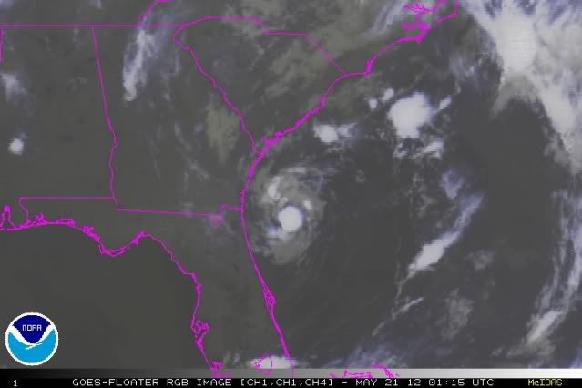
Alberto looks a bit better organized this evening based on the JAX radar loop. Eye looks slightly better defined and a lone thunderstorm has made the IR loop slightly interesting. The TS is still moving south per the JAX radar......MGC
0 likes
-
Aric Dunn
- Category 5
- Posts: 21228
- Age: 41
- Joined: Sun Sep 19, 2004 9:58 pm
- Location: Ready for the Chase.
- Contact:
Re: ATL: ALBERTO - Tropical Storm
MGC wrote:Alberto looks a bit better organized this evening based on the JAX radar loop. Eye looks slightly better defined and a lone thunderstorm has made the IR loop slightly interesting. The TS is still moving south per the JAX radar......MGC
well its the first time I have seen a curved band wraping around with the system. its is still very shallow due to the dry air. although it does appear that there is a little moisture return happening as the shortwave trough approaches. as it accelerates to the NE later tomorrow it could strengthen again. and depending on exact path the outer banks may get more of brush from it.
0 likes
Note: If I make a post that is brief. Please refer back to previous posts for the analysis or reasoning. I do not re-write/qoute what my initial post said each time.
If there is nothing before... then just ask
Space & Atmospheric Physicist, Embry-Riddle Aeronautical University,
I believe the sky is falling...
If there is nothing before... then just ask
Space & Atmospheric Physicist, Embry-Riddle Aeronautical University,
I believe the sky is falling...
-
ozonepete
- Professional-Met
- Posts: 4743
- Joined: Mon Sep 07, 2009 3:23 pm
- Location: From Ozone Park, NYC / Now in Brooklyn, NY
Re: ATL: ALBERTO - Tropical Storm
Aric Dunn wrote:MGC wrote:Alberto looks a bit better organized this evening based on the JAX radar loop. Eye looks slightly better defined and a lone thunderstorm has made the IR loop slightly interesting. The TS is still moving south per the JAX radar......MGC
well its the first time I have seen a curved band wraping around with the system. its is still very shallow due to the dry air. although it does appear that there is a little moisture return happening as the shortwave trough approaches. as it accelerates to the NE later tomorrow it could strengthen again. and depending on exact path the outer banks may get more of brush from it.
Yes. Especially because the wind field may broaden as it gets embedded in the southwesterly flow tomorrow and Tuesday.
0 likes
-
cycloneye
- Admin
- Posts: 139407
- Age: 67
- Joined: Thu Oct 10, 2002 10:54 am
- Location: San Juan, Puerto Rico
Re: ATL: ALBERTO - Recon - Mission Over
Another mission is set for Monday afternoon,unless they cancel prior to takeoff.
TROPICAL STORM ALBERTO
FLIGHT ONE -- TEAL71
A. 21/1800Z
B. AFXXX 0201A ALBERTO
C. 21/1530Z
D. 32.0N 78.5W
E. 21/1700Z TO 21/2100Z
F. SFC TO 10,000FT
TROPICAL STORM ALBERTO
FLIGHT ONE -- TEAL71
A. 21/1800Z
B. AFXXX 0201A ALBERTO
C. 21/1530Z
D. 32.0N 78.5W
E. 21/1700Z TO 21/2100Z
F. SFC TO 10,000FT
0 likes
Visit the Caribbean-Central America Weather Thread where you can find at first post web cams,radars
and observations from Caribbean basin members Click Here
and observations from Caribbean basin members Click Here
Who is online
Users browsing this forum: No registered users and 4 guests