BULLETIN
TROPICAL STORM ALBERTO ADVISORY NUMBER 6
NWS NATIONAL HURRICANE CENTER MIAMI FL AL012012
1100 PM EDT SUN MAY 20 2012
...ALBERTO BECOMING LESS ORGANIZED AND WEAKENING...
SUMMARY OF 1100 PM EDT...0300 UTC...INFORMATION
-----------------------------------------------
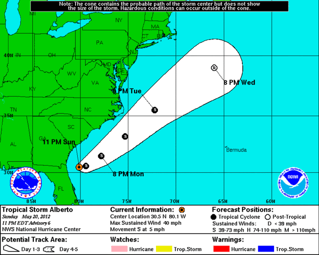
LOCATION...30.5N 80.1W
ABOUT 85 MI...135 KM ENE OF ST. AUGUSTINE FLORIDA
ABOUT 160 MI...255 KM S OF CHARLESTON SOUTH CAROLINA
MAXIMUM SUSTAINED WINDS...40 MPH...65 KM/H
PRESENT MOVEMENT...S OR 180 DEGREES AT 5 MPH...7 KM/H
MINIMUM CENTRAL PRESSURE...1007 MB...29.74 INCHES
WATCHES AND WARNINGS
--------------------
THERE ARE NO COASTAL WATCHES OR WARNINGS IN EFFECT.
DISCUSSION AND 48-HOUR OUTLOOK
------------------------------
AT 1100 PM EDT...0300 UTC...THE CENTER OF TROPICAL STORM ALBERTO WAS
LOCATED NEAR LATITUDE 30.5 NORTH...LONGITUDE 80.1 WEST. ALBERTO IS
MOVING TOWARD THE SOUTH NEAR 5 MPH...7 KM/H. A GRADUAL TURN TOWARD
THE SOUTHEAST AND EAST IS EXPECTED ON MONDAY...WITH A TURN TOWARD
THE NORTHEAST AND AN INCREASE IN FORWARD SPEED FORECAST BY EARLY
TUESDAY. ON THIS TRACK...THE CENTER OF ALBERTO IS EXPECTED TO STAY
OFFSHORE OF THE GEORGIA AND CAROLINA COASTS.
MAXIMUM SUSTAINED WINDS HAVE DECREASED TO NEAR 40 MPH...65 KM/H...
WITH HIGHER GUSTS. LITTLE CHANGE IN STRENGTH IS FORECAST DURING
THE NEXT 48 HOURS.
TROPICAL STORM FORCE WINDS EXTEND OUTWARD UP TO 70 MILES...110 KM
FROM THE CENTER.
ESTIMATED MINIMUM CENTRAL PRESSURE IS 1007 MB...29.74 INCHES.
HAZARDS AFFECTING LAND
----------------------
SURF...DANGEROUS SURF CONDITIONS...INCLUDING RIP CURRENTS...ARE
POSSIBLE ALONG THE COASTS OF NORTHEASTERN FLORIDA...GEORGIA...AND
SOUTH CAROLINA THROUGH MONDAY. PLEASE SEE STATEMENTS ISSUED BY
YOUR LOCAL NATIONAL WEATHER SERVICE OFFICE FOR INFORMATION SPECIFIC
TO YOUR AREA.
NEXT ADVISORY
-------------
NEXT COMPLETE ADVISORY...500 AM EDT.
$$
FORECASTER BLAKE
TROPICAL STORM ALBERTO DISCUSSION NUMBER 6
NWS NATIONAL HURRICANE CENTER MIAMI FL AL012012
1100 PM EDT SUN MAY 20 2012
ALBERTO HAS BEEN STRUGGLING TO PRODUCE DEEP CONVECTION THIS
EVENING...ALTHOUGH THERE ARE STILL BANDING FEATURES PRESENT ON THE
JACKSONVILLE DOPPLER RADAR. SATELLITE CLASSIFICATIONS AND DOPPLER
WIND DATA SUGGEST THE STORM HAS WEAKENED...AND THE INITIAL WIND
SPEED IS REDUCED TO 35 KT FOR THIS ADVISORY. LITTLE CHANGE IN
INTENSITY IS FORECAST BY MUCH OF THE GUIDANCE DUE TO ALBERTO MOVING
OVER WARM WATERS ALONG THE GULF STREAM...BUT IN A MODERATE-TO-
STRONG VERTICAL SHEAR ENVIRONMENT. THE NHC FORECAST SHOWS NO CHANGE
IN INTENSITY FOR THE NEXT COUPLE OF DAYS AND THEN WEAKENING AS THE
CYCLONE MOVES OVER MUCH COOLER WATERS. A PLAUSIBLE ALTERNATE
SCENARIO IS THAT THE STORM LOSES ALL DEEP CONVECTION DUE TO
MARGINAL THERMODYNAMIC CONDITIONS...AND BECOMES A REMNANT LOW IN A
DAY OR TWO.
ALBERTO HAS TURNED SOUTHWARD AND IS MOVING 180/4. THE SYSTEM IS
EMBEDDED IN A PECULIAR PLACE WITHIN THE SOUTH SIDE OF A MID- TO
UPPER-LEVEL LOW. THIS LOW IS EXPECTED TO WEAKEN AND MOVE
NORTHEASTWARD AS ANOTHER TROUGH MOVES INTO THE SOUTHEASTERN UNITED
STATES. THE MODEL GUIDANCE IS IN VERY GOOD AGREEMENT ON ALBERTO
MOVING SOUTHEASTWARD AND EASTWARD DURING THE NEXT 12 HOURS OR
SO...THEN TURNING TO THE NORTHEAST WITH INCREASING FORWARD SPEED.
THE OFFICIAL FORECAST IS CLOSE TO THE PREVIOUS ONE BUT HAS BEEN
ADJUSTED A BIT TO THE SOUTHEAST TO ACCOUNT FOR THE LATEST MODEL
TRENDS.
FORECAST POSITIONS AND MAX WINDS
INIT 21/0300Z 30.5N 80.1W 35 KT 40 MPH
12H 21/1200Z 30.6N 79.4W 35 KT 40 MPH
24H 22/0000Z 31.5N 77.8W 35 KT 40 MPH
36H 22/1200Z 33.2N 75.3W 35 KT 40 MPH
48H 23/0000Z 35.5N 72.2W 35 KT 40 MPH
72H 24/0000Z 39.0N 66.0W 30 KT 35 MPH...POST-TROP/EXTRATROP
96H 25/0000Z...DISSIPATED
$$
FORECASTER BLAKE
ATL: ALBERTO - Post-Tropical
Moderator: S2k Moderators
-
cycloneye

- Admin

- Posts: 139068
- Age: 67
- Joined: Thu Oct 10, 2002 10:54 am
- Location: San Juan, Puerto Rico
Re: ATL: ALBERTO - Advisories
0 likes
Visit the Caribbean-Central America Weather Thread where you can find at first post web cams,radars
and observations from Caribbean basin members Click Here
and observations from Caribbean basin members Click Here
-
Hurricane Jed

- Category 2

- Posts: 542
- Age: 36
- Joined: Mon Jan 24, 2011 3:36 pm
- Location: Cen Tex
-
ozonepete
- Professional-Met

- Posts: 4743
- Joined: Mon Sep 07, 2009 3:23 pm
- Location: From Ozone Park, NYC / Now in Brooklyn, NY
Re: ATL: ALBERTO - Tropical Storm
Actually, given that it will be moving over 27C water temps and moving well east of the mid-level dry air, which is moderating anyway, and will also have moderate shear instead of heavy shear, I wouldn't be surprised if this makes cat 1 on its way out to sea east of the Carolinas. Many recurving TS's in this region have done the same under similar circumstances.
Personal Forecast Disclaimer:
The posts in this forum are NOT official forecast and should not be used as such. They are just the opinion of the poster and may or may not be backed by sound meteorological data. They are NOT endorsed by any professional institution or storm2k.org. For official information, please refer to the NHC and NWS products.
0 likes
-
stormhunter7

- Category 2
- Posts: 733
- Joined: Mon May 26, 2008 3:13 pm
- Location: Panama City Beach, Florida
- Contact:
Re: ATL: ALBERTO - Tropical Storm
i know 11 sayes south... but i believe alberto is starting the turn NE... or is moving more east than south
0 likes
The following post is NOT an official forecast and should not be used as such. It is just the opinion of the poster and may or may not be backed by sound meteorological data. It is NOT endorsed by any professional institution including storm2k.org For Official Information please refer to the NHC and NWS products. http://www.nhc.noaa.gov
-
MGC

- S2K Supporter

- Posts: 5792
- Joined: Sun Mar 23, 2003 9:05 pm
- Location: Pass Christian MS, or what is left.
Re: ATL: ALBERTO - Tropical Storm
Looks like the Gulf Stream is working its magic again....convection on the increase it would appear.......MGC
0 likes
-
JonathanBelles
- Professional-Met
- Posts: 11430
- Age: 33
- Joined: Sat Dec 24, 2005 9:00 pm
- Location: School: Florida State University (Tallahassee, FL) Home: St. Petersburg, Florida
- Contact:
Overnight tropical update! Again, thanks to Stacey Garvilla for the pictures! If you have pictures, send them to me and I will feature them on my blog.
http://jonathanbelles.wordpress.com/201 ... -update-2/
http://jonathanbelles.wordpress.com/201 ... -update-2/
0 likes
-
Aric Dunn
- Category 5

- Posts: 21228
- Age: 41
- Joined: Sun Sep 19, 2004 9:58 pm
- Location: Ready for the Chase.
- Contact:
looks much better.
0 likes
Note: If I make a post that is brief. Please refer back to previous posts for the analysis or reasoning. I do not re-write/qoute what my initial post said each time.
If there is nothing before... then just ask
Space & Atmospheric Physicist, Embry-Riddle Aeronautical University,
I believe the sky is falling...
If there is nothing before... then just ask
Space & Atmospheric Physicist, Embry-Riddle Aeronautical University,
I believe the sky is falling...
-
JonathanBelles
- Professional-Met
- Posts: 11430
- Age: 33
- Joined: Sat Dec 24, 2005 9:00 pm
- Location: School: Florida State University (Tallahassee, FL) Home: St. Petersburg, Florida
- Contact:
-
Evil Jeremy

- S2K Supporter
- Posts: 5459
- Age: 30
- Joined: Mon Apr 10, 2006 2:10 pm
- Location: Los Angeles, CA
Re: ATL: ALBERTO - Tropical Storm
Is it me, or does the NHC no longer have storm specific GOES satellite imagery like in years past? Ive been trying to find their one for Alberto.
0 likes
Frances 04 / Jeanne 04 / Katrina 05 / Wilma 05 / Fay 08 / Debby 12 / Andrea 13 / Colin 16 / Hermine 16 / Matthew 16 / Irma 17
-
cycloneye
- Admin
- Posts: 139068
- Age: 67
- Joined: Thu Oct 10, 2002 10:54 am
- Location: San Juan, Puerto Rico
Re: ATL: ALBERTO - Advisories
TROPICAL STORM ALBERTO DISCUSSION NUMBER 7
NWS NATIONAL HURRICANE CENTER MIAMI FL AL012012
500 AM EDT MON MAY 21 2012
DEEP CONVECTION HAS REFORMED NEAR THE CENTER OF ALBERTO AGAIN THIS
MORNING WITH BROKEN RAINBANDS CONTINUING AROUND THE CENTER. THE
INITIAL WIND SPEED IS HELD AT 35 KT...ALTHOUGH SATELLITE INTENSITY
ESTIMATES SUGGEST THAT ALBERTO COULD BE WEAKER. THE TROPICAL STORM
IS QUITE COMPACT WITH ITS ASSOCIATED CLOUDINESS EXTENDING NO MORE
THAN 150 N MI ACROSS. EVEN THOUGH ALBERTO HAS MOVED BACK OVER THE
GULF STREAM...WHERE SEA SURFACE TEMPERATURES ARE RELATIVELY
WARM...VERY DRY AIR AROUND THE CYCLONE AND STRONG
WEST-SOUTHWESTERLY SHEAR SHOULD SUPPRESS SIGNIFICANT STRENGTHENING.
THE OFFICIAL FORECAST...THEREFORE...KEEPS ALBERTO AT THE SAME
INTENSITY FOR THE NEXT DAY OR TWO...IN AGREEMENT WITH ALL OF THE
INTENSITY GUIDANCE. ALTHOUGH NOT EXPLICITLY SHOWN BELOW...ALBERTO
IS EXPECTED TO TRANSITION TO A POST-TROPICAL CYCLONE AFTER 48 HOURS
AND BEFORE DISSIPATION IN ABOUT THREE DAYS.
THE TROPICAL STORM IS MOVING SLOWLY SOUTHEASTWARD OFF THE
NORTHEAST FLORIDA COAST...NEARLY COMPLETING THE ANTICIPATED
COUNTER-CLOCKWISE LOOP. AN EASTWARD MOTION IS EXPECTED TO BEGIN
TODAY AS AN AMPLIFYING MID- TO UPPER-LEVEL TROUGH APPROACHES THE
CYCLONE. A TURN TO THE NORTHEAST WITH AN INCREASE IN FORWARD SPEED
IS FORECAST TO OCCUR TONIGHT AND TUESDAY...TAKING THE COMPACT
TROPICAL STORM PARALLEL TO...BUT OFFSHORE...OF THE SOUTHEAST UNITED
STATES COASTLINE. THE NHC TRACK FORECAST HAS BEEN ADJUSTED SLIGHTLY
TO THE EAST AND LIES BETWEEN THE GFS AND ECMWF SOLUTIONS.
FORECAST POSITIONS AND MAX WINDS
INIT 21/0900Z 30.4N 79.7W 35 KT 40 MPH
12H 21/1800Z 30.6N 78.7W 35 KT 40 MPH
24H 22/0600Z 31.8N 76.8W 35 KT 40 MPH
36H 22/1800Z 33.5N 74.3W 35 KT 40 MPH
48H 23/0600Z 35.5N 71.5W 30 KT 35 MPH
72H 24/0600Z...DISSIPATED
$$
FORECASTER CANGIALOSI
0 likes
Visit the Caribbean-Central America Weather Thread where you can find at first post web cams,radars
and observations from Caribbean basin members Click Here
and observations from Caribbean basin members Click Here

Re: ATL: ALBERTO - Tropical Storm
Evil Jeremy wrote:Is it me, or does the NHC no longer have storm specific GOES satellite imagery like in years past? Ive been trying to find their one for Alberto.
The links are here: http://www.ssd.noaa.gov/PS/TROP/floaters.html
The floaters have changed naming format to be storm specific for some reason that I can't find - but there they are.
Here are the floaters for Alberto (01L): http://www.ssd.noaa.gov/PS/TROP/floater ... oater.html
0 likes
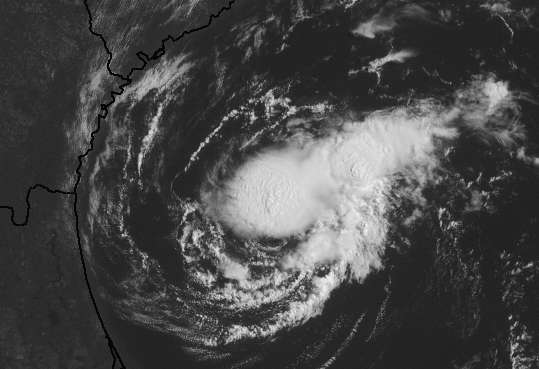
Re: ATL: ALBERTO - Tropical Storm
First visible image for Alberto this morning, with fcst track

0 likes


-
northjaxpro

- S2K Supporter
- Posts: 8900
- Joined: Mon Sep 27, 2010 11:21 am
- Location: Jacksonville, FL
Alberto's convection has waned significantly in the past several hours. Also, it appears that he is about to complete the cyclonic loop. He's been drifting south-southeast overnight, but the upper level trough approaching the Ohio Valley currently should begin to pick up Alberto to the northeast later today.
0 likes
NEVER, EVER SAY NEVER in the tropics and weather in general, and most importantly, with life itself!!
________________________________________________________________________________________
Fay 2008 Beryl 2012 Debby 2012 Colin 2016 Hermine 2016 Julia 2016 Matthew 2016 Irma 2017 Dorian 2019
________________________________________________________________________________________
Fay 2008 Beryl 2012 Debby 2012 Colin 2016 Hermine 2016 Julia 2016 Matthew 2016 Irma 2017 Dorian 2019

Re: ATL: ALBERTO - Tropical Storm
CAPE at about 1000 completely surrounding the circulation. Seems dry air less of an issue today
http://www.spc.noaa.gov/exper/mesoanaly ... 7602530261
Nice overshooting tops showing up on VIS
http://www.ssd.noaa.gov/PS/TROP/floater ... 0-lalo.jpg
Still some life left
http://www.spc.noaa.gov/exper/mesoanaly ... 7602530261
Nice overshooting tops showing up on VIS
http://www.ssd.noaa.gov/PS/TROP/floater ... 0-lalo.jpg
Still some life left
0 likes
-
Aric Dunn
- Category 5
- Posts: 21228
- Age: 41
- Joined: Sun Sep 19, 2004 9:58 pm
- Location: Ready for the Chase.
- Contact:
nice convective burst. reaching 60k ft for the first time. very strong returns on radar right around the center. looks like it has about 12 hours of decent conditions to strengthen.
0 likes
Note: If I make a post that is brief. Please refer back to previous posts for the analysis or reasoning. I do not re-write/qoute what my initial post said each time.
If there is nothing before... then just ask
Space & Atmospheric Physicist, Embry-Riddle Aeronautical University,
I believe the sky is falling...
If there is nothing before... then just ask
Space & Atmospheric Physicist, Embry-Riddle Aeronautical University,
I believe the sky is falling...
-
tolakram
- Admin
- Posts: 19165
- Age: 60
- Joined: Sun Aug 27, 2006 8:23 pm
- Location: Florence, KY (name is Mark)
Re: ATL: ALBERTO - Tropical Storm
0 likes
M a r k
- - - - -
Join us in chat: Storm2K Chatroom Invite. Android and IOS apps also available.
The posts in this forum are NOT official forecasts and should not be used as such. Posts are NOT endorsed by any professional institution or STORM2K.org. For official information and forecasts, please refer to NHC and NWS products.
-
Aric Dunn
- Category 5
- Posts: 21228
- Age: 41
- Joined: Sun Sep 19, 2004 9:58 pm
- Location: Ready for the Chase.
- Contact:
long range radar showing a almost complete donut of deep convection right around the center. and has maintained for over an hour. probably up to 50mph or 55. Also its sitting over the warmest part of the gulf stream for the next 12 hours or so.
0 likes
Note: If I make a post that is brief. Please refer back to previous posts for the analysis or reasoning. I do not re-write/qoute what my initial post said each time.
If there is nothing before... then just ask
Space & Atmospheric Physicist, Embry-Riddle Aeronautical University,
I believe the sky is falling...
If there is nothing before... then just ask
Space & Atmospheric Physicist, Embry-Riddle Aeronautical University,
I believe the sky is falling...
Who is online
Users browsing this forum: No registered users and 103 guests