BULLETIN
TROPICAL DEPRESSION BERYL ADVISORY NUMBER 13
NWS NATIONAL HURRICANE CENTER MIAMI FL AL022012
1100 PM EDT MON MAY 28 2012
...BERYL REMAINS AN INLAND TROPICAL DEPRESSION...
SUMMARY OF 1100 PM EDT...0300 UTC...INFORMATION
-----------------------------------------------
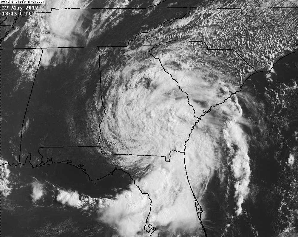
LOCATION...30.8N 83.4W
ABOUT 165 MI...260 KM WSW OF SAVANNAH GEORGIA
ABOUT 60 MI...95 KM ENE OF TALLAHASSEE FLORIDA
MAXIMUM SUSTAINED WINDS...30 MPH...45 KM/H
PRESENT MOVEMENT...NW OR 320 DEGREES AT 5 MPH...7 KM/H
MINIMUM CENTRAL PRESSURE...1005 MB...29.68 INCHES
WATCHES AND WARNINGS
--------------------
THERE ARE NO COASTAL WATCHES OR WARNINGS IN EFFECT.
DISCUSSION AND 48-HOUR OUTLOOK
------------------------------
AT 1100 PM EDT...0300 UTC...THE CENTER OF TROPICAL DEPRESSION BERYL
WAS LOCATED NEAR LATITUDE 30.8 NORTH...LONGITUDE 83.4 WEST. THE
DEPRESSION IS MOVING TOWARD THE NORTHWEST NEAR 5 MPH...7 KM/H. A
TURN TOWARD THE EAST-NORTHEAST WITH A GRADUAL INCREASE IN FORWARD
SPEED SHOULD BEGIN ON TUESDAY. THIS MOTION WILL BRING THE
CIRCULATION OF BERYL OVER THE SOUTHERN PORTIONS OF GEORGIA AND
SOUTH CAROLINA DURING THE NEXT 36 HOURS. BERYL IS FORECAST TO MOVE
OVER THE WESTERN ATLANTIC ON WEDNESDAY AND PASS NEAR THE
SOUTHEASTERN COAST OF NORTH CAROLINA.
MAXIMUM SUSTAINED WINDS ARE NEAR 30 MPH...45 KM/H...WITH HIGHER
GUSTS. BERYL IS ANTICIPATED TO REMAIN A TROPICAL DEPRESSION WHILE
OVER LAND. AFTER MOVING BACK OVER WATER WEDNESDAY...
REINTENSIFICATION TO A TROPICAL STORM IS FORECAST TO OCCUR.
ESTIMATED MINIMUM CENTRAL PRESSURE IS 1005 MB...29.68 INCHES.
HAZARDS AFFECTING LAND
----------------------
WIND...ISOLATED TROPICAL STORM FORCE WIND GUSTS ARE STILL POSSIBLE
OVER NORTHEASTERN FLORIDA AND SOUTHEASTERN GEORGIA TONIGHT AND
TUESDAY...PARTICULARLY IN RAINBANDS.
SURF...DANGEROUS SURF CONDITIONS...INCLUDING RIP CURRENTS...ARE
STILL POSSIBLE ALONG THE COAST FROM NORTHEASTERN FLORIDA TO
NORTH CAROLINA THROUGH TONIGHT. PLEASE SEE STATEMENTS ISSUED BY YOUR
LOCAL NATIONAL WEATHER SERVICE OFFICE FOR INFORMATION SPECIFIC TO
YOUR AREA.
RAINFALL...BERYL IS EXPECTED TO PRODUCE TOTAL RAIN ACCUMULATIONS OF
5 TO 10 INCHES...WITH ISOLATED MAXIMUM AMOUNTS OF 15 INCHES...IN
NORTHERN FLORIDA AND SOUTHEASTERN GEORGIA. BERYL IS ALSO EXPECTED
TO PRODUCE 3 TO 6 INCHES OF RAIN IN EASTERN NORTH CAROLINA AND SOUTH
CAROLINA.
NEXT ADVISORY
-------------
NEXT COMPLETE ADVISORY...500 AM EDT.
$$
FORECASTER LANDSEA
TROPICAL DEPRESSION BERYL DISCUSSION NUMBER 13
NWS NATIONAL HURRICANE CENTER MIAMI FL AL022012
1100 PM EDT MON MAY 28 2012
WHILE MOST OF THE CIRCULATION OF BERYL IS INLAND...THE CYCLONE
CONTINUES TO DISPLAY A RATHER SYMMETRIC WIND FIELD IN ADDITION TO
WELL-DEFINED BANDING AS OBSERVED BY THE WSR-88D RADAR AND SATELLITE
IMAGERY. PEAK WINDS IN THIS SYSTEM...NEAR 25 KT...HAVE BEEN
OCCURRING ALONG THE NORTHEAST FLORIDA AND SOUTHERN GEORGIA COASTS
AS MEASURED BY SOME WEATHERFLOW WEATHER STATIONS.
BERYL IS SLOWLY MOVING TOWARD THE NORTHWEST OR 320/3. AS A VIGOROUS
SHORT-WAVE TROUGH CURRENTLY WEST OF THE GREAT LAKES APPROACHES THE
CYCLONE...BERYL WILL TURN TOWARD THE EAST-NORTHEAST IN ABOUT A DAY.
THE SYSTEM WILL THEN ACCELERATE IN THAT DIRECTION FOR THE
NEXT FEW DAYS THEREAFTER. THE TRACK FORECAST IS SLIGHTLY TO THE
RIGHT AND FASTER THAN THE PREVIOUS ADVISORY AND VERY CLOSE TO THE
TVCA CONSENSUS MODEL.
AS LONG AS IT MAINTAINS ITS DEEP CONVECTION...BERYL IS ANTICIPATED
TO REMAIN A TROPICAL DEPRESSION FOR THE NEXT 36 HOURS...WHILE IT IS
MOVING SLOWLY ACROSS GEORGIA AND SOUTH CAROLINA. BY WEDNESDAY
MORNING...BERYL SHOULD BE REACHING THE ATLANTIC OCEAN AGAIN. THERE
IS A NARROW SWATH OF WARM OCEAN WITHIN THE GULF STREAM BETWEEN THE
COOL SHELF WATERS AND THE REMAINDER OF THE WESTERN ATLANTIC. BERYL
HAS ABOUT A DAY OF TRAVERSING THE GULF STREAM WHILE THE VERTICAL
SHEAR IS MODERATE TO ALLOW SOME REINTENSIFICATION BACK TO A
TROPICAL STORM. THE INTENSITY FORECAST IS VERY SIMILAR TO A BLEND
OF THE LGEM STATISTICAL AND HWRF DYNAMICAL MODELS AS WELL AS THE
PREVIOUS ADVISORY. IN ABOUT THREE DAYS...THE CYCLONE SHOULD
TRANSITION TO AN EXTRATROPICAL CYCLONE AS DEPICTED BY THE FSU
CYCLONE PHASE SPACE DIAGRAMS. ABSORPTION OF BERYL INTO A LARGER
EXTRATROPICAL CYCLONE IS INDICATED AFTER FOUR DAYS CONSISTENT WITH
THE ECMWF AND CANADIAN MODELS. HOWEVER...OTHER MODELS SUGGEST THAT
BERYL MAY BECOME THE DOMINANT VORTEX AND REMAIN INTACT LONGER.
THE MAIN CONCERN WITH SLOW MOVING BERYL CONTINUES TO BE VERY HEAVY
RAINS WHICH ARE EXPECTED TO OCCUR FROM NORTHERN FLORIDA AND
SOUTHEASTERN GEORGIA DURING THE NEXT TWO DAYS.
FORECAST POSITIONS AND MAX WINDS
INIT 29/0300Z 30.8N 83.4W 25 KT 30 MPH...INLAND
12H 29/1200Z 31.3N 83.3W 25 KT 30 MPH...INLAND
24H 30/0000Z 32.1N 81.6W 25 KT 30 MPH...INLAND
36H 30/1200Z 33.2N 79.3W 30 KT 35 MPH...INLAND
48H 31/0000Z 34.6N 76.2W 35 KT 40 MPH...OVER WATER
72H 01/0000Z 37.5N 67.0W 40 KT 45 MPH...POST-TROP/EXTRATROP
96H 02/0000Z 40.0N 54.0W 40 KT 45 MPH...POST-TROP/EXTRATROP
120H 03/0000Z...DISSIPATED
$$
FORECASTER LANDSEA
ATL: BERYL - Post-Tropical
Moderator: S2k Moderators
-
cycloneye

- Admin

- Posts: 139011
- Age: 67
- Joined: Thu Oct 10, 2002 10:54 am
- Location: San Juan, Puerto Rico
Re: ATL: BERYL - Advisories
0 likes
Visit the Caribbean-Central America Weather Thread where you can find at first post web cams,radars
and observations from Caribbean basin members Click Here
and observations from Caribbean basin members Click Here
-
northjaxpro

- S2K Supporter

- Posts: 8900
- Joined: Mon Sep 27, 2010 11:21 am
- Location: Jacksonville, FL
Good evening everyone.
It has been an amazing past 24 hours for me here in Jax. It has been a day for clean-up around my home as I had some down trees and power lines in and around my neighborhood. JEA has come out and finally got most of that cleaned up and just in the past hour or so my power is now back on after being out for over 24 hours. thankfully, I had a generator to keep us going, but all is finally somewhat back to some sort of normalcy after Beryl's landfall here last night. When I was able to get out there and measure the winds, I managed a peak gust of 67 mph at around 11:30 pm, just as Beryl made landfall on Jacksonville Beach. I had sustained winds easily around 50 mph at the time Beryl passed over my home location. The center of the storm moved directly across the width of then entier Duval/Jax metro area. It was truly remarkable for this area, in which I already explained in a post earlier today that is the first time a tropical cyclone has done that for Jax area.
Now, we had a break from the rain for most of the afternoon after Beryl moved west-northwest inland to just past I-75 corridor before she weakened to depression and has come to a stall. Total rainfall here at my home in north Jax ended up being just over 6 inches as of late tonight. Now, the feederbands have come back around rotating from southwest to northeast around Beryl's circulation back into the Jax metro. It has started to rain again and I expect some heavy rain again overnight and will add more to my total.
I am OK and am thankful along with everyone in this area that although we took a direct hit from Beryl, it could have been far worse. She has done a lot to put a tremendous dent into the drought we have suffered since last September, so I am very grateful for that.
Last edited by northjaxpro on Tue May 29, 2012 6:47 am, edited 2 times in total.
0 likes
NEVER, EVER SAY NEVER in the tropics and weather in general, and most importantly, with life itself!!
________________________________________________________________________________________
Fay 2008 Beryl 2012 Debby 2012 Colin 2016 Hermine 2016 Julia 2016 Matthew 2016 Irma 2017 Dorian 2019
________________________________________________________________________________________
Fay 2008 Beryl 2012 Debby 2012 Colin 2016 Hermine 2016 Julia 2016 Matthew 2016 Irma 2017 Dorian 2019
-
northjaxpro
- S2K Supporter
- Posts: 8900
- Joined: Mon Sep 27, 2010 11:21 am
- Location: Jacksonville, FL
Cycloneye, thanks for posting that loop of Beryl's landfall. Tonight is my first time on the blog after all the clean-up I had to do today and I think that loop is fascinating showing Beryl's track all the way to late Monday night.
0 likes
NEVER, EVER SAY NEVER in the tropics and weather in general, and most importantly, with life itself!!
________________________________________________________________________________________
Fay 2008 Beryl 2012 Debby 2012 Colin 2016 Hermine 2016 Julia 2016 Matthew 2016 Irma 2017 Dorian 2019
________________________________________________________________________________________
Fay 2008 Beryl 2012 Debby 2012 Colin 2016 Hermine 2016 Julia 2016 Matthew 2016 Irma 2017 Dorian 2019

Re: ATL: BERYL - Tropical Depression
ROCK wrote:see how she tightens up right before landfall....classic land interaction allowing the circulation to slow down and wrap....got to be a paper on this somewhere...
The 82-83 deg SSTs of the gulf stream east of Jacksonville had probably more to do with it, becoming tropical as it tracked over it. IMO.
0 likes
-
cycloneye
- Admin
- Posts: 139011
- Age: 67
- Joined: Thu Oct 10, 2002 10:54 am
- Location: San Juan, Puerto Rico
Re:
northjaxpro wrote:Cycloneye, thanks for posting that loop of Beryl's landfall. Tonight is my first tim e on the blog after all the clean-up I had to do today and I think that loop is fascinating showing Beryl's track all the way to late Monday night.
Great to see that you and family are fine and that as you said,it could have been worse in that area.
0 likes
Visit the Caribbean-Central America Weather Thread where you can find at first post web cams,radars
and observations from Caribbean basin members Click Here
and observations from Caribbean basin members Click Here
-
northjaxpro
- S2K Supporter
- Posts: 8900
- Joined: Mon Sep 27, 2010 11:21 am
- Location: Jacksonville, FL
Thanks cycloneye! Beryl packed a punch for sure. It goes to show that strong tropical storms can cause significant problems. But, again, I am thankful it is only late May and not July. This could have been a major disaster for Jax if this was a strong cat 1 or cat 2 hurricane for certain. Thank God it wasn't for sure!
0 likes
NEVER, EVER SAY NEVER in the tropics and weather in general, and most importantly, with life itself!!
________________________________________________________________________________________
Fay 2008 Beryl 2012 Debby 2012 Colin 2016 Hermine 2016 Julia 2016 Matthew 2016 Irma 2017 Dorian 2019
________________________________________________________________________________________
Fay 2008 Beryl 2012 Debby 2012 Colin 2016 Hermine 2016 Julia 2016 Matthew 2016 Irma 2017 Dorian 2019
-
TeamPlayersBlue

- Category 5

- Posts: 3307
- Joined: Tue Feb 02, 2010 1:44 am
- Location: Denver/Applewood, CO
I missed the excitement! Ive been in Leakey Texas on the frio river since Thursday afternoon, and we go off the grid when youre out there. Your cell phone doesnt work and we didnt watch any tv. I heard on Sunday afternoon about the storm and was very surprised to see a JAX landing. WEll back to catching up on all that i missed on the forum!
0 likes
Personal Forecast Disclaimer:
The posts in this forum are NOT official forecast and should not be used as such. They are just the opinion of the poster and may or may not be backed by sound meteorological data. They are NOT endorsed by any professional institution or storm2k.org. For official information, please refer to the NHC and NWS products.
The posts in this forum are NOT official forecast and should not be used as such. They are just the opinion of the poster and may or may not be backed by sound meteorological data. They are NOT endorsed by any professional institution or storm2k.org. For official information, please refer to the NHC and NWS products.
-
CrazyC83
- Professional-Met

- Posts: 33393
- Joined: Tue Mar 07, 2006 11:57 pm
- Location: Deep South, for the first time!
Re:
northjaxpro wrote:Thanks cycloneye! Beryl packed a punch for sure. It goes to show that strong tropical storms can cause significant problems. But, again, I am thankful it is only late May and not July. This could have been a major disaster for Jax if this was a strong cat 1 or cat 2 hurricane for certain. Thank God it wasn't for sure!
Anytime hurricane conditions are felt in a major metropolitan area, it would be a very difficult situation. The power outages alone would be a huge problem.
0 likes

Re:
northjaxpro wrote:Thanks cycloneye! Beryl packed a punch for sure. It goes to show that strong tropical storms can cause significant problems. But, again, I am thankful it is only late May and not July. This could have been a major disaster for Jax if this was a strong cat 1 or cat 2 hurricane for certain. Thank God it wasn't for sure!
Thank you so much for your posts describing the effects of the storm on your area.
Hope that the damage and inconvenience was minimal for you, family and friends.
Again, thanks for the updates!
0 likes
-
northjaxpro
- S2K Supporter
- Posts: 8900
- Joined: Mon Sep 27, 2010 11:21 am
- Location: Jacksonville, FL
Re: Re:
fci wrote:northjaxpro wrote:Thanks cycloneye! Beryl packed a punch for sure. It goes to show that strong tropical storms can cause significant problems. But, again, I am thankful it is only late May and not July. This could have been a major disaster for Jax if this was a strong cat 1 or cat 2 hurricane for certain. Thank God it wasn't for sure!
Thank you so much for your posts describing the effects of the storm on your area.
Hope that the damage and inconvenience was minimal for you, family and friends.
Again, thanks for the updates!
You are welcome. I think Storm2K is the best by having knowledgable pros and other bloggers on this site. It turns out that I experienced the season's first landfalling tropical cyclone and the strongest ever in history during the month of May in the Atlantic basin. Amazing!
0 likes
NEVER, EVER SAY NEVER in the tropics and weather in general, and most importantly, with life itself!!
________________________________________________________________________________________
Fay 2008 Beryl 2012 Debby 2012 Colin 2016 Hermine 2016 Julia 2016 Matthew 2016 Irma 2017 Dorian 2019
________________________________________________________________________________________
Fay 2008 Beryl 2012 Debby 2012 Colin 2016 Hermine 2016 Julia 2016 Matthew 2016 Irma 2017 Dorian 2019
-
northjaxpro
- S2K Supporter
- Posts: 8900
- Joined: Mon Sep 27, 2010 11:21 am
- Location: Jacksonville, FL
As I retire for the evening getting some moderate steady rain falling from feederbands spiraling into Beryl's circulation. looks like another inch or two more of rain when I check the gauge later into the morning. Hope the Riverside area and Sam Marco areas of Jax don't flood again.
What a memorable day folks for me everyone which I am grateful is finally over in the aftermath of Beryl.
What a memorable day folks for me everyone which I am grateful is finally over in the aftermath of Beryl.
0 likes
NEVER, EVER SAY NEVER in the tropics and weather in general, and most importantly, with life itself!!
________________________________________________________________________________________
Fay 2008 Beryl 2012 Debby 2012 Colin 2016 Hermine 2016 Julia 2016 Matthew 2016 Irma 2017 Dorian 2019
________________________________________________________________________________________
Fay 2008 Beryl 2012 Debby 2012 Colin 2016 Hermine 2016 Julia 2016 Matthew 2016 Irma 2017 Dorian 2019
-
cycloneye
- Admin
- Posts: 139011
- Age: 67
- Joined: Thu Oct 10, 2002 10:54 am
- Location: San Juan, Puerto Rico
Re: ATL: BERYL - Advisories
BULLETIN
TROPICAL DEPRESSION BERYL ADVISORY NUMBER 14
NWS NATIONAL HURRICANE CENTER MIAMI FL AL022012
500 AM EDT TUE MAY 29 2012
...BERYL TO TURN NORTHEASTWARD TODAY...
SUMMARY OF 500 AM EDT...0900 UTC...INFORMATION
----------------------------------------------
LOCATION...30.9N 83.4W
ABOUT 10 MI...15 KM NW OF VALDOSTA GEORGIA
ABOUT 160 MI...255 KM WSW OF SAVANNAH GEORGIA
MAXIMUM SUSTAINED WINDS...30 MPH...45 KM/H
PRESENT MOVEMENT...N OR 360 DEGREES AT 2 MPH...4 KM/H
MINIMUM CENTRAL PRESSURE...1005 MB...29.68 INCHES
WATCHES AND WARNINGS
--------------------
THERE ARE NO COASTAL WATCHES OR WARNINGS IN EFFECT.
DISCUSSION AND 48-HOUR OUTLOOK
------------------------------
AT 500 AM EDT...0900 UTC...THE CENTER OF TROPICAL DEPRESSION BERYL
WAS LOCATED NEAR LATITUDE 30.9 NORTH...LONGITUDE 83.4 WEST. BERYL
IS MOVING TOWARD THE NORTH NEAR 2 MPH...4 KM/H. A TURN TOWARD THE
NORTHEAST WITH AN INCREASE IN FORWARD SPEED IS EXPECTED LATER
TODAY...BRINGING THE CENTER OF BERYL CLOSE TO THE COAST OF SOUTH
CAROLINA BY EARLY WEDNESDAY MORNING AND BACK OVER ATLANTIC WATERS
BY LATE WEDNESDAY.
MAXIMUM SUSTAINED WINDS ARE NEAR 30 MPH...45 KM/H...WITH HIGHER
GUSTS. LITTLE CHANGE IN STRENGTH IS EXPECTED TODAY...BUT SOME
STRENGTHENING IS LIKELY AS BERYL APPROACHES THE COASTLINE AND
ACCELERATES ON WEDNESDAY...WHEN BERYL COULD REGAIN TROPICAL STORM
STATUS.
ESTIMATED MINIMUM CENTRAL PRESSURE IS 1005 MB...29.68 INCHES.
HAZARDS AFFECTING LAND
----------------------
WIND...ISOLATED TROPICAL-STORM-FORCE WIND GUSTS ARE STILL POSSIBLE
OVER NORTHEASTERN FLORIDA AND SOUTHEASTERN GEORGIA TODAY...
PARTICULARLY IN RAINBANDS.
SURF...DANGEROUS SURF CONDITIONS...INCLUDING RIP CURRENTS...ARE
STILL POSSIBLE ALONG THE COAST FROM NORTHEASTERN FLORIDA TO NORTH
CAROLINA TODAY. FOR INFORMATION SPECIFIC TO YOUR AREA...PLEASE SEE
STATEMENTS ISSUED BY YOUR LOCAL NATIONAL WEATHER SERVICE OFFICE.
RAINFALL...BERYL IS EXPECTED TO PRODUCE TOTAL RAIN ACCUMULATIONS OF
5 TO 10 INCHES...WITH ISOLATED MAXIMUM AMOUNTS OF 15 INCHES...IN
NORTHERN FLORIDA AND SOUTHEASTERN GEORGIA. BERYL IS EXPECTED
TO PRODUCE TOTAL RAIN ACCUMULATIONS OF 3 TO 6 INCHES IN EASTERN
SOUTH CAROLINA AND EASTERN NORTH CAROLINA.
NEXT ADVISORY
-------------
NEXT COMPLETE ADVISORY...1100 AM EDT.
$$
FORECASTER FRANKLIN
TROPICAL DEPRESSION BERYL DISCUSSION NUMBER 14
NWS NATIONAL HURRICANE CENTER MIAMI FL AL022012
500 AM EDT TUE MAY 29 2012
BERYL IS STILL GENERATING DEEP CONVECTION IN A FEW BANDS TO THE
EAST AND SOUTH OF THE CENTER...AND SO IT STILL QUALIFIES AS A
TROPICAL CYCLONE...ALTHOUGH OVER THE PAST SEVERAL HOURS THE RADAR
PRESENTATION NEAR THE CENTER HAS DEGRADED. SURFACE OBSERVATIONS...
AS WELL AS RADAR AND SATELLITE IMAGERY INDICATE THAT THE WESTWARD
COMPONENT OF MOTION HAS ENDED...AND THE INITIAL MOTION IS 360/2.
THE STRONGEST WINDS...ESTIMATED TO BE ABOUT 25 KT...ARE OVER WATER
AND WELL REMOVED FROM THE CENTER.
THERE HAS BEEN NO SIGNIFICANT CHANGE TO THE FORECAST REASONING. A
MID-LEVEL RIDGE OVER THE EASTERN UNITED STATES IS FORECAST TO
WEAKEN AND MOVE EASTWARD WITH THE APPROACH OF A SHORT-WAVE TROUGH
CURRENTLY APPROACHING THE GREAT LAKES. THIS PATTERN SHOULD
BEGIN TO ACCELERATE BERYL NORTHEASTWARD VERY SHORTLY...LIKELY TAKING
THE CENTER BACK OVER WATER WITHIN 24 TO 36 HOURS. FOR AN
ACCELERATING SYSTEM...THE MODEL GUIDANCE IS IN VERY GOOD
AGREEMENT...AT LEAST THROUGH 72 HOURS. THE OFFICIAL FORECAST
ESSENTIALLY BLENDS THE ECMWF AND GFS GUIDANCE...WITH MORE
WEIGHT PLACED ON THE SLOWER ECMWF.
BERYL WILL HAVE AN OPPORTUNITY TO REGAIN TROPICAL STORM STRENGH AS
IT ACCELERATES AND MOVES OFFSHORE AND OVER THE WARM GULF STREAM
WATERS...IN WHAT SHOULD STILL BE A RELATIVELY LOW SHEAR ENVIRONMENT.
ALTHOUGH THE OFFICIAL FORECAST SHOWS A TROPICAL STORM CENTERED VERY
NEAR THE NORTH CAROLINA COAST IN 36 HOURS...IT IS EXPECTED THAT
TROPICAL-STORM-FORCE WINDS WOULD BE CONFINED TO THE SOUTHEAST AND
OFFSHORE QUADRANT OF THE CYCLONE. AS A RESULT...NO COASTAL WATCHES
OR WARNINGS CURRENTLY SEEM NECESSARY.
A FRONTAL TROUGH ASSOCIATED WITH THE GREAT LAKES SHORT-WAVE IS SHOWN
OVERTAKING BERYL IN ABOUT 66 HOURS IN THE GFS...AND IN ABOUT 84
HOURS IN THE ECMWF. BASED ON THIS GUIDANCE AND THE EXPECTED COOLER
WATERS BELOW THE CYCLONE BY THAT TIME...EXTRATROPICAL TRANSITION IS
CALLED FOR ON DAY THREE...FOLLOWED BY DISSIPATION.
FORECAST POSITIONS AND MAX WINDS
INIT 29/0900Z 30.9N 83.4W 25 KT 30 MPH
12H 29/1800Z 31.5N 82.6W 25 KT 30 MPH...INLAND
24H 30/0600Z 32.4N 80.7W 30 KT 35 MPH...INLAND
36H 30/1800Z 33.7N 78.0W 35 KT 40 MPH...OVER WATER
48H 31/0600Z 35.5N 74.3W 40 KT 45 MPH
72H 01/0600Z 38.0N 65.0W 40 KT 45 MPH...POST-TROP/EXTRATROP
96H 02/0600Z...DISSIPATED
$$
FORECASTER FRANKLIN
0 likes
Visit the Caribbean-Central America Weather Thread where you can find at first post web cams,radars
and observations from Caribbean basin members Click Here
and observations from Caribbean basin members Click Here
-
northjaxpro
- S2K Supporter
- Posts: 8900
- Joined: Mon Sep 27, 2010 11:21 am
- Location: Jacksonville, FL
I received just over an inch overnight and now my rain total is 7.25 inches with this event with Beryl to this point and still raining this morning. Taking a quick look at radar and satellite imagery, it now appears that the LLC of Beryl may be beginning its northeast movement. Right now the LLC is located about 50 miles west of Waycross, GA.
Feederbands rotating into the circulation continues to move over Northeast FL and SE GA this morning and there will be more impressive rain totals with these tropical downpours across the region today, hence the flood watch.

Feederbands rotating into the circulation continues to move over Northeast FL and SE GA this morning and there will be more impressive rain totals with these tropical downpours across the region today, hence the flood watch.
0 likes
NEVER, EVER SAY NEVER in the tropics and weather in general, and most importantly, with life itself!!
________________________________________________________________________________________
Fay 2008 Beryl 2012 Debby 2012 Colin 2016 Hermine 2016 Julia 2016 Matthew 2016 Irma 2017 Dorian 2019
________________________________________________________________________________________
Fay 2008 Beryl 2012 Debby 2012 Colin 2016 Hermine 2016 Julia 2016 Matthew 2016 Irma 2017 Dorian 2019
-
tolakram
- Admin
- Posts: 19165
- Age: 60
- Joined: Sun Aug 27, 2006 8:23 pm
- Location: Florence, KY (name is Mark)
Re: ATL: BERYL - Tropical Depression
0 likes
M a r k
- - - - -
Join us in chat: Storm2K Chatroom Invite. Android and IOS apps also available.
The posts in this forum are NOT official forecasts and should not be used as such. Posts are NOT endorsed by any professional institution or STORM2K.org. For official information and forecasts, please refer to NHC and NWS products.
-
Mouton
- S2K Supporter
- Posts: 212
- Age: 78
- Joined: Sat Jul 30, 2011 8:13 am
- Location: Amelia Island Florida
Re:
northjaxpro wrote:As I retire for the evening getting some moderate steady rain falling from feederbands spiraling into Beryl's circulation. looks like another inch or two more of rain when I check the gauge later into the morning. Hope the Riverside area and Sam Marco areas of Jax don't flood again.
What a memorable day folks for me everyone which I am grateful is finally over in the aftermath of Beryl.
Raining moderately up here now at 10AM in Fernandina. Gusting to 15 or so. Spent yesterday picking up the yard debis....quite a bit but no damage here or in my neighborhood. Some homes along the immediate coast lost shingles most of those were older roofs. A few trees came down in my 150 home neighborhood, fortunately not on anyone's home. So albeit the weekend was ruined, at least we got the much needed rain fall. We did not lose power either....quite a few flashes though and each time my pc powered down during the evening. Got to point just left it off as did not want any electrical surge damage. Spent day cleaning up yard, have a 8ft long 3foot high tree debris pile now.
Need to make a car trip to Jax today....hopefully after noon this band will be by the area. If not, tomorrow is another day.
0 likes
-
Tampa Bay Hurricane

- Category 5
- Posts: 5594
- Age: 36
- Joined: Fri Jul 22, 2005 7:54 pm
- Location: St. Petersburg, FL
Re: ATL: BERYL - Tropical Depression
Clearwater Beach's buoy recorded a wind gust to 39 mph around 924 AM (about an hour ago)
as Beryl's outer band of showers came through.
http://www.ndbc.noaa.gov/station_page.php?station=CWBF1
as Beryl's outer band of showers came through.
http://www.ndbc.noaa.gov/station_page.php?station=CWBF1
0 likes
-
cycloneye
- Admin
- Posts: 139011
- Age: 67
- Joined: Thu Oct 10, 2002 10:54 am
- Location: San Juan, Puerto Rico
Re: ATL: BERYL - Advisories
BULLETIN
TROPICAL DEPRESSION BERYL ADVISORY NUMBER 15
NWS NATIONAL HURRICANE CENTER MIAMI FL AL022012
1100 AM EDT TUE MAY 29 2012
...BERYL MOVING SLOWLY NORTHEASTWARD PRODUCING HEAVY RAINS...
SUMMARY OF 1100 AM EDT...1500 UTC...INFORMATION
-----------------------------------------------
LOCATION...31.5N 82.9W
ABOUT 115 MI...185 KM WSW OF SAVANNAH GEORGIA
ABOUT 55 MI...85 KM NNE OF VALDOSTA GEORGIA
MAXIMUM SUSTAINED WINDS...30 MPH...45 KM/H
PRESENT MOVEMENT...NE OR 50 DEGREES AT 5 MPH...7 KM/H
MINIMUM CENTRAL PRESSURE...1005 MB...29.68 INCHES
WATCHES AND WARNINGS
--------------------
THERE ARE NO COASTAL WATCHES OR WARNINGS IN EFFECT.
DISCUSSION AND 48-HOUR OUTLOOK
------------------------------
AT 1100 AM EDT...1500 UTC...THE CENTER OF TROPICAL DEPRESSION BERYL
WAS LOCATED NEAR LATITUDE 31.5 NORTH...LONGITUDE 82.9 WEST. THE
DEPRESSION IS MOVING TOWARD THE NORTHEAST NEAR 5 MPH...7 KM/H. A
GRADUAL INCREASE IN FORWARD SPEED IS EXPECTED TO BEGIN LATER
TODAY...BRINGING THE CENTER OF BERYL CLOSE TO THE COAST OF SOUTH
CAROLINA BY WEDNESDAY MORNING AND BACK OVER ATLANTIC WATERS
BY LATE WEDNESDAY.
MAXIMUM SUSTAINED WINDS ARE NEAR 30 MPH...45 KM/H...WITH HIGHER
GUSTS. LITTLE CHANGE IN STRENGTH IS EXPECTED TODAY...BUT BERYL
COULD REGAIN TROPICAL STORM STATUS ON WEDNESDAY AS IT APPROACHES
THE COASTLINE.
THE ESTIMATED MINIMUM CENTRAL PRESSURE IS 1005 MB...29.68 INCHES.
HAZARDS AFFECTING LAND
----------------------
WIND...ISOLATED TROPICAL-STORM-FORCE WIND GUSTS ARE STILL POSSIBLE
OVER NORTHEASTERN FLORIDA AND SOUTHEASTERN GEORGIA TODAY...
PARTICULARLY IN RAINBANDS.
SURF...DANGEROUS SURF CONDITIONS...INCLUDING RIP CURRENTS...ARE
STILL POSSIBLE ALONG THE COAST FROM NORTHEASTERN FLORIDA TO NORTH
CAROLINA TODAY. FOR INFORMATION SPECIFIC TO YOUR AREA...PLEASE SEE
STATEMENTS ISSUED BY YOUR LOCAL NATIONAL WEATHER SERVICE OFFICE.
RAINFALL...BERYL IS EXPECTED TO PRODUCE TOTAL RAIN ACCUMULATIONS OF
5 TO 10 INCHES...WITH ISOLATED MAXIMUM AMOUNTS OF 15 INCHES...IN
NORTHERN FLORIDA AND SOUTHEASTERN GEORGIA. BERYL IS EXPECTED
TO PRODUCE TOTAL RAIN ACCUMULATIONS OF 3 TO 6 INCHES IN EASTERN
SOUTH CAROLINA AND EASTERN NORTH CAROLINA.
NEXT ADVISORY
-------------
NEXT COMPLETE ADVISORY...500 PM EDT.
$$
FORECASTER AVILA
TROPICAL DEPRESSION BERYL DISCUSSION NUMBER 15
NWS NATIONAL HURRICANE CENTER MIAMI FL AL022012
1100 AM EDT TUE MAY 29 2012
SATELLITE IMAGES...RADAR AND SURFACE OBSERVATIONS SHOW A PERSISTENT
CIRCULATION AND A WELL DEFINED CONVECTIVE CURVED BAND LOCATED TO
THE EAST AND SOUTHEAST OF THE CENTER. THE INITIAL INTENSITY IS
ESTIMATED TO BE 25 KNOTS...BUT THESE WINDS ARE OCCURRING PRIMARILY
IN THE AFOREMENTIONED CONVECTIVE BAND. NOT MUCH CHANGE IN INTENSITY
IS EXPECTED TODAY WHILE THE CENTER IS OVER LAND. THERE IS AN
OPPORTUNITY FOR BERYL TO REGAIN TROPICAL STORM STRENGTH AS THE
CIRCULATION MOVES OVER THE WARM WATERS OF THE GULF STREAM BETWEEN
24 AND 36 HOURS. GLOBAL MODELS SUGGEST THAT BERYL WILL BECOME
EXTRATROPICAL IN 72 HOURS OR EVEN EARLIER...AND THEN BECOME
ABSORBED BY A LARGER EXTRATROPICAL CYCLONE. THIS IS INDICATED IN
THE OFFICIAL FORECAST.
THE DEPRESSION IS NOW MOVING TOWARD THE NORTHEAST OR 050 DEGREES AT
4 KNOTS...STEERED BY THE WESTERLIES AROUND THE BASE OF AN EASTWARD-
MOVING SHORT WAVE CURRENTLY OVER THE CENTRAL UNITED STATES. A
GENERAL NORTHEAST MOTION SHOULD CONTINUE FOR THE NEXT FEW DAYS WITH
A GRADUAL INCREASE IN FORWARD SPEED AS THE SHORT WAVE AMPLIFIES.
MOST OF THE TRACK MODELS AGREE ON THIS SOLUTION.
ALTHOUGH THE OFFICIAL FORECAST SHOWS A TROPICAL STORM CENTERED VERY
NEAR THE NORTH CAROLINA COAST IN 36 HOURS...IT IS EXPECTED THAT
TROPICAL-STORM-FORCE WINDS WOULD BE CONFINED TO THE SOUTHEAST AND
OFFSHORE QUADRANT OF THE CYCLONE. AS A RESULT...NO COASTAL WATCHES
OR WARNINGS CURRENTLY SEEM NECESSARY.
FORECAST POSITIONS AND MAX WINDS
INIT 29/1500Z 31.5N 82.9W 25 KT 30 MPH
12H 30/0000Z 32.2N 81.6W 25 KT 30 MPH...INLAND
24H 30/1200Z 33.3N 79.2W 30 KT 35 MPH...INLAND
36H 31/0000Z 34.7N 76.3W 35 KT 40 MPH...OVER WATER
48H 31/1200Z 36.2N 72.0W 40 KT 45 MPH
72H 01/1200Z 40.0N 62.0W 40 KT 45 MPH...POST-TROP/EXTRATROP
96H 02/1200Z...DISSIPATED
$$
FORECASTER AVILA
0 likes
Visit the Caribbean-Central America Weather Thread where you can find at first post web cams,radars
and observations from Caribbean basin members Click Here
and observations from Caribbean basin members Click Here
-
cycloneye
- Admin
- Posts: 139011
- Age: 67
- Joined: Thu Oct 10, 2002 10:54 am
- Location: San Juan, Puerto Rico
Re: ATL: BERYL - Recon
The mission for tommorow afternoon is a go.
NOUS42 KNHC 291430
WEATHER RECONNAISSANCE FLIGHTS
CARCAH, NATIONAL HURRICANE CENTER, MIAMI, FL.
1030 AM EDT TUE 29 MAY 2012
SUBJECT: TROPICAL CYCLONE PLAN OF THE DAY (TCPOD)
VALID 30/1100Z TO 31/1100Z MAY 2012
TCPOD NUMBER.....12-011
I. ATLANTIC REQUIREMENTS
1. TROPICAL DEPRESSION BERYL
FLIGHT ONE -- TEAL 70
A. 30/1800Z, 31/0000Z
B. AFXXX 0402A BERYL
C. 30/1530Z
D. 34.0N 78.5W
E. 30/1730Z TO 31/0000Z
F. SFC TO 10,000 FT
2. OUTLOOK FOR SUCCEEDING DAY.....NEGATIVE.
0 likes
Visit the Caribbean-Central America Weather Thread where you can find at first post web cams,radars
and observations from Caribbean basin members Click Here
and observations from Caribbean basin members Click Here
-
AnnularCane

- S2K Supporter
- Posts: 2630
- Joined: Thu Jun 08, 2006 9:18 am
- Location: Wytheville, VA
Who is online
Users browsing this forum: No registered users and 21 guests