WPAC: GUCHOL - Post-Tropical

Moderator: S2k Moderators

Message
Author
dexterlabio
Category 5
Category 5
Posts: 3406
Joined: Sat Oct 24, 2009 11:50 pm

Re: WPAC: GUCHOL - Typhoon (05W)

#381 Postby dexterlabio » Mon Jun 18, 2012 2:21 am

ClarkEligue wrote:In my observation, usually when a storm gets to an angle in relation to the Philippine Archipelago, the maximum effect of the Southwest Monsoon is felt in Metro Manila and in areas in Southwest Luzon and Western Visayas.

That area would be anywhere East of Northern Luzon, especially east of Batanes and Cagayan provinces.


good observation. :) TC's passing over Batanes dumped lots of rain even as far south in Manila because of the enhanced monsoon. one storm i couldn't forget is TS Bilis in 2006, I almost thought then it was the storm itself that caused the strong rains and winds but it was actually the monsoon. :lol:

still IMO PAGASA should also focus on determining the intensity of the monsoon being pulled by these storms at certain times and inform the public about it. there were lots of TC's veering north of PI but it was actually the monsoon which causes all the trouble...that being said, i think posting radar images regularly is the solution...
0 likes   
Personal Forecast Disclaimer:
The posts in this forum are NOT official forecast and should not be used as such. They are just the opinion of the poster and may or may not be backed by sound meteorological data. They are NOT endorsed by any professional institution or storm2k.org. For official information, please refer to the NHC and NWS products.

User avatar
Infdidoll
Category 2
Category 2
Posts: 667
Age: 46
Joined: Thu Oct 01, 2009 8:39 pm
Location: Temecula, CA

#382 Postby Infdidoll » Mon Jun 18, 2012 2:22 am

The rumor mill on Kadena Air Base's page is going insane, right now, with everything from "Can I flush my toilet?", to "There is another typhoon coming right this way and it's going to HIT us!", to "We're in TCOR 1-C! Everyone needs to get home now!"

Oh boy. It's only going to get worse as the night goes on. I linked those who want serious weather info to the agencies, westernpacificweather.com, Storm2K, etc.
0 likes   

dexterlabio
Category 5
Category 5
Posts: 3406
Joined: Sat Oct 24, 2009 11:50 pm

Re: WPAC: GUCHOL - Typhoon (05W)

#383 Postby dexterlabio » Mon Jun 18, 2012 2:24 am

Infdidoll wrote:Is it just me or is the storm not quite veering NE yet? If it doesn't start a sharp recurve soon, I'm wondering if we could end up feeling a little more intensity than we previously thought.


also seems to move more northward than NE...how's the weather in your place right now?
0 likes   
Personal Forecast Disclaimer:
The posts in this forum are NOT official forecast and should not be used as such. They are just the opinion of the poster and may or may not be backed by sound meteorological data. They are NOT endorsed by any professional institution or storm2k.org. For official information, please refer to the NHC and NWS products.

Typhoon Hunter
WesternPacificWeather.com
Posts: 1215
Age: 40
Joined: Wed Oct 11, 2006 11:37 am
Location: Hong Kong
Contact:

Re: WPAC: GUCHOL - Typhoon (05W)

#384 Postby Typhoon Hunter » Mon Jun 18, 2012 2:27 am

Looks like it's on track NNE to me from radar and latest JMA hourly update seems to confirm.
0 likes   
James - Documenting typhoons...

http://www.youtube.com/TyphoonHunter

User avatar
Infdidoll
Category 2
Category 2
Posts: 667
Age: 46
Joined: Thu Oct 01, 2009 8:39 pm
Location: Temecula, CA

Re: WPAC: GUCHOL - Typhoon (05W)

#385 Postby Infdidoll » Mon Jun 18, 2012 2:31 am

dexterlabio wrote:
Infdidoll wrote:Is it just me or is the storm not quite veering NE yet? If it doesn't start a sharp recurve soon, I'm wondering if we could end up feeling a little more intensity than we previously thought.


also seems to move more northward than NE...how's the weather in your place right now?


The outer storm bands are over us, now. Very little rain, so far. Some sprinkling. Wind speeds are picking up (I haven't checked the obs, yet). Started off a bright, sunny day and conditions continue to deteriorate. Hardly any waves on this side of the island but you can visibly see the surface being disturbed by the winds. A few good gusts big enough to knock over a big, plastic tub I had sitting outside the door ready to bring in. Everything is in, now, but the satellite dish. The jury has been out on whether or not we should bring it in. So far, it's not too bad at all, though I can hear the winds picking up outside.
0 likes   

User avatar
Infdidoll
Category 2
Category 2
Posts: 667
Age: 46
Joined: Thu Oct 01, 2009 8:39 pm
Location: Temecula, CA

#386 Postby Infdidoll » Mon Jun 18, 2012 2:48 am

Last few frames do seem to show a NNE movement. Had me worried for a few. Earlier frames seemed to have it going due north. :D
0 likes   

phwxenthusiast
Category 2
Category 2
Posts: 637
Joined: Wed Mar 24, 2010 3:10 am
Location: Holbrook, NY (Long Island)

#387 Postby phwxenthusiast » Mon Jun 18, 2012 2:53 am

if only the EWRC happened faster, Guchol might be a little stronger compared to what it is now... MWI still showing a closed eyewall with deep convection all around...

Image
0 likes   

RobWESTPACWX
WestPACMet
WestPACMet
Posts: 1616
Joined: Fri Sep 17, 2010 2:26 am
Location: Tokyo, Japan
Contact:

#388 Postby RobWESTPACWX » Mon Jun 18, 2012 3:09 am

If anyone has any photos of the storm moving over Japan in the Next 24hrs please share them here and I might be able to get them on to NHK WORLD or on my video update this evening. But as always be smart when taking pictures or video.
0 likes   
Satellites, Charts and Forecasting tools for East Asia at WESTERNPACIFICWEATHER.COM

RobWESTPACWX
WestPACMet
WestPACMet
Posts: 1616
Joined: Fri Sep 17, 2010 2:26 am
Location: Tokyo, Japan
Contact:

#389 Postby RobWESTPACWX » Mon Jun 18, 2012 3:15 am

18kt sustained in Kadena at this time, a rain band is moving over head so click this link to see the latest reports.

http://www.aviationweather.gov/adds/met ... translated
0 likes   
Satellites, Charts and Forecasting tools for East Asia at WESTERNPACIFICWEATHER.COM

RobWESTPACWX
WestPACMet
WestPACMet
Posts: 1616
Joined: Fri Sep 17, 2010 2:26 am
Location: Tokyo, Japan
Contact:

#390 Postby RobWESTPACWX » Mon Jun 18, 2012 3:27 am

Also ROAH is the ICAO for NAHA airport, click here for there reports.

http://www.aviationweather.gov/adds/met ... met=Submit
0 likes   
Satellites, Charts and Forecasting tools for East Asia at WESTERNPACIFICWEATHER.COM

RobWESTPACWX
WestPACMet
WestPACMet
Posts: 1616
Joined: Fri Sep 17, 2010 2:26 am
Location: Tokyo, Japan
Contact:

#391 Postby RobWESTPACWX » Mon Jun 18, 2012 4:31 am

Tropical Storm Force Gust currently being reported in Okinawa, expect conditions to continue to continue to decrease rapidly.
0 likes   
Satellites, Charts and Forecasting tools for East Asia at WESTERNPACIFICWEATHER.COM

RobWESTPACWX
WestPACMet
WestPACMet
Posts: 1616
Joined: Fri Sep 17, 2010 2:26 am
Location: Tokyo, Japan
Contact:

#392 Postby RobWESTPACWX » Mon Jun 18, 2012 4:36 am

0 likes   
Satellites, Charts and Forecasting tools for East Asia at WESTERNPACIFICWEATHER.COM

User avatar
Infdidoll
Category 2
Category 2
Posts: 667
Age: 46
Joined: Thu Oct 01, 2009 8:39 pm
Location: Temecula, CA

Re: WPAC: GUCHOL - Typhoon (05W)

#393 Postby Infdidoll » Mon Jun 18, 2012 4:53 am

Thanks for all the updates, Rob. I've been working on some of the packing up for our move. Sounds like the winds are starting to pick up. We JUST had our first "screaming" wind gust, but still relatively mild. I'm sure the worst will start happening soon.
0 likes   

francis327
WesternPacificWeather.com
Posts: 81
Joined: Mon Nov 07, 2011 9:04 am
Location: Kuala Lumpur, Malaysia
Contact:

Re: WPAC: GUCHOL - Typhoon (05W)

#394 Postby francis327 » Mon Jun 18, 2012 5:15 am

Latest from JMA.

Image[/URL]
0 likes   
WESTERNPACIFICWEATHER.COM

User avatar
Infdidoll
Category 2
Category 2
Posts: 667
Age: 46
Joined: Thu Oct 01, 2009 8:39 pm
Location: Temecula, CA

#395 Postby Infdidoll » Mon Jun 18, 2012 5:20 am

A certain idiot I know just went out to try to get video. I am now drenched to the bone.
0 likes   

RobWESTPACWX
WestPACMet
WestPACMet
Posts: 1616
Joined: Fri Sep 17, 2010 2:26 am
Location: Tokyo, Japan
Contact:

#396 Postby RobWESTPACWX » Mon Jun 18, 2012 5:20 am

Sure will , outer rainbands already moving on shore. Some of them coudl get intense.
0 likes   
Satellites, Charts and Forecasting tools for East Asia at WESTERNPACIFICWEATHER.COM

User avatar
Infdidoll
Category 2
Category 2
Posts: 667
Age: 46
Joined: Thu Oct 01, 2009 8:39 pm
Location: Temecula, CA

Re:

#397 Postby Infdidoll » Mon Jun 18, 2012 5:26 am

RobWESTPACWX wrote:Sure will , outer rainbands already moving on shore. Some of them coudl get intense.


lol...They are definitely here! I just got my second shower of the day courtesy of mother nature. lol
0 likes   

francis327
WesternPacificWeather.com
Posts: 81
Joined: Mon Nov 07, 2011 9:04 am
Location: Kuala Lumpur, Malaysia
Contact:

Re:

#398 Postby francis327 » Mon Jun 18, 2012 5:27 am

Infdidoll wrote:A certain idiot I know just went out to try to get video. I am now drenched to the bone.


Be careful and stay safe. A shot of it sure does values but safety comes first though.
Wind is going down and pressure is going up but still, it is a threatening wind.
JMA forecast it will gone extratropical in the next 72 hour.

JMA Advisories #60
WTPQ20 RJTD 180900
RSMC TROPICAL CYCLONE ADVISORY
NAME TY 1204 GUCHOL (1204)
ANALYSIS
PSTN 180900UTC 24.6N 128.2E GOOD
MOVE NNE 17KT
PRES 955HPA
MXWD 080KT
GUST 115KT
50KT 100NM SOUTHEAST 60NM NORTHWEST
30KT 240NM SOUTHEAST 180NM NORTHWEST
FORECAST
24HF 190900UTC 34.6N 135.3E 85NM 70%
MOVE NNE 26KT
PRES 965HPA
MXWD 070KT
GUST 100KT
45HF 200600UTC 40.0N 139.6E 180NM 70%
MOVE NNE 21KT
PRES 985HPA
MXWD 050KT
GUST 070KT
69HF 210600UTC 41.8N 145.8E 250NM 70% EXTRATROPICAL LOW =
0 likes   
WESTERNPACIFICWEATHER.COM

User avatar
Infdidoll
Category 2
Category 2
Posts: 667
Age: 46
Joined: Thu Oct 01, 2009 8:39 pm
Location: Temecula, CA

Re: WPAC: GUCHOL - Typhoon (05W)

#399 Postby Infdidoll » Mon Jun 18, 2012 5:52 am

I'm fine! In nice, warm clothes now! The winds weren't too bad but being hit in the face by wind-driven rain isn't much fun. I'd probably make a good storm videographer if I wasn't so worried about my mascara being smeared. I look like Alice Cooper now but am not any worse for wear. :D I really live for this stuff and am going to be really sad in a few weeks when the most exciting thing going on are Virginia snow storms. :P
0 likes   

tolakram
Admin
Admin
Posts: 19165
Age: 60
Joined: Sun Aug 27, 2006 8:23 pm
Location: Florence, KY (name is Mark)

Re: WPAC: GUCHOL - Typhoon (05W)

#400 Postby tolakram » Mon Jun 18, 2012 6:28 am

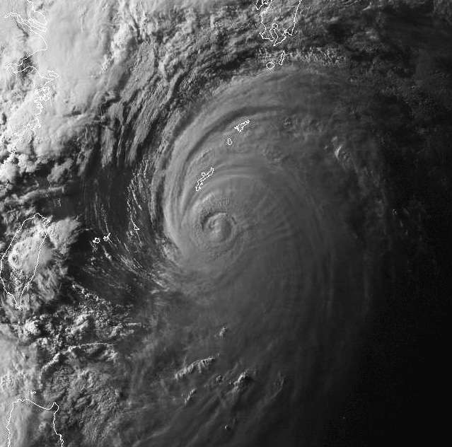
Last Visible of the day, from a few hours ago.
Image

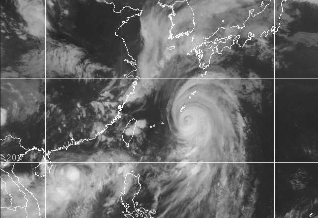
Latest IR
Image
0 likes   
M a r k
- - - - -
Join us in chat: Storm2K Chatroom Invite. Android and IOS apps also available.

The posts in this forum are NOT official forecasts and should not be used as such. Posts are NOT endorsed by any professional institution or STORM2K.org. For official information and forecasts, please refer to NHC and NWS products.


Return to “2012”

Who is online

Users browsing this forum: No registered users and 51 guests