WPAC: GUCHOL - Post-Tropical

Moderator: S2k Moderators

Message
Author
User avatar
Infdidoll
Category 2
Category 2
Posts: 667
Age: 46
Joined: Thu Oct 01, 2009 8:39 pm
Location: Temecula, CA

Re:

#421 Postby Infdidoll » Mon Jun 18, 2012 9:15 pm

RobWESTPACWX wrote:This works, Im going to use it at the start of the video I'm doing now


Cool! That was neat to see. Glad to help out. I'm sure this storm won't be quite as strong when it gets up there, but hope you guys stay safe.

I ended up crashing out, last night, after it was evident that the storm wasn't going to get any stronger for us. No damage to report here, this morning. :wink:
0 likes   

User avatar
Infdidoll
Category 2
Category 2
Posts: 667
Age: 46
Joined: Thu Oct 01, 2009 8:39 pm
Location: Temecula, CA

Re:

#422 Postby Infdidoll » Mon Jun 18, 2012 9:23 pm

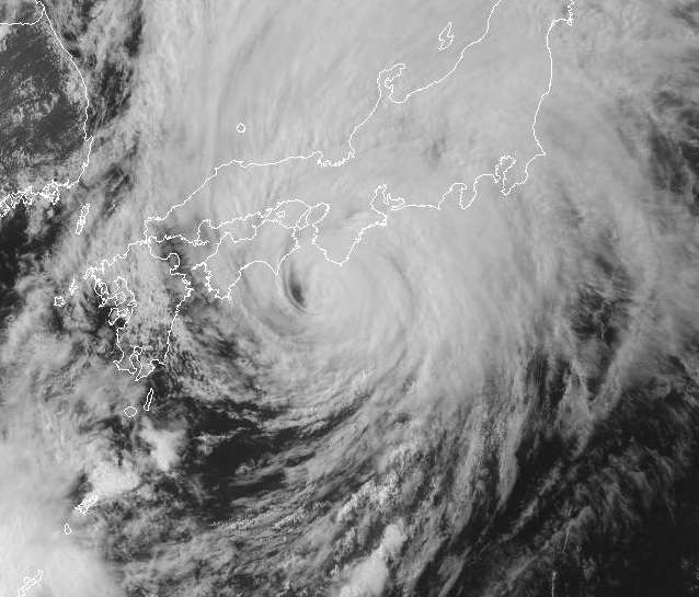
RobWESTPACWX wrote:I hope everyone here knows that the Radiation is well under control in Fukushima Diachi and that its effects in the coming days are nothing compared to the strong storm moving on shore.

I spoke to a few Japanese Mets today, and all of them laugh every time someone announces radiation is going to be stirred up. Please. Calm down foreign people. LOL


Are you serious? People are STILL going on about radiation? I still remember how calmly the news was reported on NHK after the earthquake and how hysterical people in the States were getting. My mother, not usually the worrying type, was calling me demanding I get a flight out of here NOW (to where? Through Tokyo where most Okinawa planes are routed taking me closer to the radiation? lol).

American news outlets have gotten SO irresponsible with their reporting. It's all about sensationalizing and hyping EVERYTHING. No wonder we have to be the most medicated country in the world, right now. You have to be if you watch the news and actually believe it. Everything is so overdramatic. lol

It's sad to say, this would probably never happen in the States: http://www.bbc.co.uk/news/world-asia-pacific-13598607
0 likes   

User avatar
cycloneye
Admin
Admin
Posts: 139010
Age: 67
Joined: Thu Oct 10, 2002 10:54 am
Location: San Juan, Puerto Rico

Re: WPAC: GUCHOL - Typhoon (05W)

#423 Postby cycloneye » Mon Jun 18, 2012 9:26 pm

:uarrow: That is very good news Infdidoll. It weakened bigtime as it moved to your east.
0 likes   
Visit the Caribbean-Central America Weather Thread where you can find at first post web cams,radars
and observations from Caribbean basin members Click Here

CrazyC83
Professional-Met
Professional-Met
Posts: 33393
Joined: Tue Mar 07, 2006 11:57 pm
Location: Deep South, for the first time!

#424 Postby CrazyC83 » Mon Jun 18, 2012 9:46 pm

How well does Japan handle typhoons of similar intensity (i.e. Category 1)?
0 likes   

RobWESTPACWX
WestPACMet
WestPACMet
Posts: 1616
Joined: Fri Sep 17, 2010 2:26 am
Location: Tokyo, Japan
Contact:

Re: WPAC: GUCHOL - Typhoon (05W)

#425 Postby RobWESTPACWX » Mon Jun 18, 2012 10:22 pm

To answer the question above, Japan is very battle hardened when it comes to Typhoons. Really the major threat is a disruption of peoples daily life with most storms. I.e train delays etc.

Any how here is my latest video.

[youtube]http://www.youtube.com/watch?v=G0Kvr6AI75Q[/youtube]
0 likes   
Satellites, Charts and Forecasting tools for East Asia at WESTERNPACIFICWEATHER.COM

RobWESTPACWX
WestPACMet
WestPACMet
Posts: 1616
Joined: Fri Sep 17, 2010 2:26 am
Location: Tokyo, Japan
Contact:

#426 Postby RobWESTPACWX » Tue Jun 19, 2012 1:44 am

Guchol has a scary resemblence to Talas last year as far as how hard and where the rainfall is occuring. On the other hand it is moving much much faster. http://www.jma.go.jp/en/amedas/211.html?elementCode=0
0 likes   
Satellites, Charts and Forecasting tools for East Asia at WESTERNPACIFICWEATHER.COM

RobWESTPACWX
WestPACMet
WestPACMet
Posts: 1616
Joined: Fri Sep 17, 2010 2:26 am
Location: Tokyo, Japan
Contact:

Re: WPAC: GUCHOL - Typhoon (05W)

#427 Postby RobWESTPACWX » Tue Jun 19, 2012 1:46 am

Latest Radar shot, short time from now before the storm makes landfall.

Image
0 likes   
Satellites, Charts and Forecasting tools for East Asia at WESTERNPACIFICWEATHER.COM

User avatar
Infdidoll
Category 2
Category 2
Posts: 667
Age: 46
Joined: Thu Oct 01, 2009 8:39 pm
Location: Temecula, CA

Re: WPAC: GUCHOL - Typhoon (05W)

#428 Postby Infdidoll » Tue Jun 19, 2012 1:46 am

Most of the locals around here get excited when they hear a typhoon is coming. It's usually a GOOD thing. A few local divers say it cleans out the waters around Okinawa and washes off a lot of dust that makes its way over from China. The factories near me have employees there working during the weaker typhoons. They absolutely don't secure a thing until the wind is already blowing pretty hard. Weaker typhoons mean business as usual for Okinawans. Some people pray for snow days, Okinawans love typhoons. They have lived here for all these years in the path of them so they have been smart and built the whole island accordingly. No completely wood-structure buildings.

Sometimes, we see young people out surfing during some of the weaker storms. Most businesses also stay open. Our electricity usually always stays on, as well, and if it goes out, you will literally see guys out repairing wires during the storm. I've never seen anything like it. This is a way of life for them.

After Songda, my husband went out very early in the morning and said the streets looked like a warzone. I left with him about an hour later and he was shocked at how much everyone had gone out and cleaned up in the span of an hour. They are extremely industrious folks and because they built well, typhoons usually end up being a hiccup in their day. I'm still kind of in shock that the U.S. doesn't have more building codes, etc. in hurricane prone areas.
0 likes   

User avatar
Infdidoll
Category 2
Category 2
Posts: 667
Age: 46
Joined: Thu Oct 01, 2009 8:39 pm
Location: Temecula, CA

Re: WPAC: GUCHOL - Typhoon (05W)

#429 Postby Infdidoll » Tue Jun 19, 2012 1:48 am

The rainfall is pretty bad, right now. My husband just said his unit got sent home from work early because of extreme flooding. He said there was 3 ft of water in front of the shop where he works. :eek:

It's been raining heavily all day with no signs of letting up.
0 likes   

phwxenthusiast
Category 2
Category 2
Posts: 637
Joined: Wed Mar 24, 2010 3:10 am
Location: Holbrook, NY (Long Island)

Re: WPAC: GUCHOL - Typhoon (05W)

#430 Postby phwxenthusiast » Tue Jun 19, 2012 3:37 am

Infdidoll wrote:The rainfall is pretty bad, right now. My husband just said his unit got sent home from work early because of extreme flooding. He said there was 3 ft of water in front of the shop where he works. :eek:

It's been raining heavily all day with no signs of letting up.


wow those are pretty heavy rains... i think you may get more rainfall today and tonight than you did with Guchol yesterday hehe...
0 likes   

RobWESTPACWX
WestPACMet
WestPACMet
Posts: 1616
Joined: Fri Sep 17, 2010 2:26 am
Location: Tokyo, Japan
Contact:

#431 Postby RobWESTPACWX » Tue Jun 19, 2012 3:55 am

Typhoon Guchol has officially made landfall at the tip of the Kii Pen according to JMA.
0 likes   
Satellites, Charts and Forecasting tools for East Asia at WESTERNPACIFICWEATHER.COM

RobWESTPACWX
WestPACMet
WestPACMet
Posts: 1616
Joined: Fri Sep 17, 2010 2:26 am
Location: Tokyo, Japan
Contact:

#432 Postby RobWESTPACWX » Tue Jun 19, 2012 4:10 am

Thus far the strongest winds recorded in Japan today have been 51kts in Okinawa, still below Typhoon Strength.

http://www.data.jma.go.jp/obd/stats/dat ... html#mxwsp
0 likes   
Satellites, Charts and Forecasting tools for East Asia at WESTERNPACIFICWEATHER.COM

RobWESTPACWX
WestPACMet
WestPACMet
Posts: 1616
Joined: Fri Sep 17, 2010 2:26 am
Location: Tokyo, Japan
Contact:

#433 Postby RobWESTPACWX » Tue Jun 19, 2012 4:13 am

Nevermind, found one other report up to 70kts, thats a wind gust though, sustained is still below typhoon strenght on all the reports, im sure there was some winds not recorded though.
0 likes   
Satellites, Charts and Forecasting tools for East Asia at WESTERNPACIFICWEATHER.COM

RobWESTPACWX
WestPACMet
WestPACMet
Posts: 1616
Joined: Fri Sep 17, 2010 2:26 am
Location: Tokyo, Japan
Contact:

#434 Postby RobWESTPACWX » Tue Jun 19, 2012 5:31 am

Im a little suprised this storm is still a TY, considering no TY sustained winds have been reported yet and its completly fallen apart with all the rainfall in the right side of the storm now. I think 15 min we will see this downgrade, if now Im very suprised.
0 likes   
Satellites, Charts and Forecasting tools for East Asia at WESTERNPACIFICWEATHER.COM

RobWESTPACWX
WestPACMet
WestPACMet
Posts: 1616
Joined: Fri Sep 17, 2010 2:26 am
Location: Tokyo, Japan
Contact:

#435 Postby RobWESTPACWX » Tue Jun 19, 2012 5:32 am

Thats by JMA, not JTWC...
0 likes   
Satellites, Charts and Forecasting tools for East Asia at WESTERNPACIFICWEATHER.COM

User avatar
cycloneye
Admin
Admin
Posts: 139010
Age: 67
Joined: Thu Oct 10, 2002 10:54 am
Location: San Juan, Puerto Rico

Re: WPAC: GUCHOL - Typhoon (05W)

#436 Postby cycloneye » Tue Jun 19, 2012 6:20 am

0 likes   
Visit the Caribbean-Central America Weather Thread where you can find at first post web cams,radars
and observations from Caribbean basin members Click Here

francis327
WesternPacificWeather.com
Posts: 81
Joined: Mon Nov 07, 2011 9:04 am
Location: Kuala Lumpur, Malaysia
Contact:

#437 Postby francis327 » Tue Jun 19, 2012 10:08 am

So now a STS at 970hPa? seems like my previous assumption still holds. JMA somewhat correlates the wind speed and storm category with pressure. :)
0 likes   
WESTERNPACIFICWEATHER.COM

tolakram
Admin
Admin
Posts: 19165
Age: 60
Joined: Sun Aug 27, 2006 8:23 pm
Location: Florence, KY (name is Mark)

Re: WPAC: GUCHOL - Typhoon (05W)

#438 Postby tolakram » Tue Jun 19, 2012 10:09 am

One of the last visibles, before making landfall. From earlier today.

Image
0 likes   
M a r k
- - - - -
Join us in chat: Storm2K Chatroom Invite. Android and IOS apps also available.

The posts in this forum are NOT official forecasts and should not be used as such. Posts are NOT endorsed by any professional institution or STORM2K.org. For official information and forecasts, please refer to NHC and NWS products.

francis327
WesternPacificWeather.com
Posts: 81
Joined: Mon Nov 07, 2011 9:04 am
Location: Kuala Lumpur, Malaysia
Contact:

#439 Postby francis327 » Tue Jun 19, 2012 10:10 am

WTPQ20 RJTD 191200
RSMC TROPICAL CYCLONE ADVISORY
NAME STS 1204 GUCHOL (1204) DOWNGRADED FROM TY
ANALYSIS
PSTN 191200UTC 35.1N 137.6E GOOD
MOVE NE 38KT
PRES 970HPA
MXWD 060KT
GUST 085KT
50KT 100NM SOUTHEAST 60NM NORTHWEST
30KT 270NM SOUTHEAST 180NM NORTHWEST
FORECAST
24HF 201200UTC 40.6N 144.2E 85NM 70% EXTRATROPICAL LOW =
0 likes   
WESTERNPACIFICWEATHER.COM

tolakram
Admin
Admin
Posts: 19165
Age: 60
Joined: Sun Aug 27, 2006 8:23 pm
Location: Florence, KY (name is Mark)

Re: WPAC: GUCHOL - Typhoon (05W)

#440 Postby tolakram » Tue Jun 19, 2012 10:12 am

Latest IR

Image
0 likes   
M a r k
- - - - -
Join us in chat: Storm2K Chatroom Invite. Android and IOS apps also available.

The posts in this forum are NOT official forecasts and should not be used as such. Posts are NOT endorsed by any professional institution or STORM2K.org. For official information and forecasts, please refer to NHC and NWS products.


Return to “2012”

Who is online

Users browsing this forum: No registered users and 16 guests