BEGIN
NHC_ATCF
invest_ep942012.invest
FSTDA
R
U
040
010
0000
201208101740
NONE
NOTIFY=ATRP
END
INVEST, EP, E, , , , , 94, 2012, DB, O, 2012081018, 9999999999, , , , , , METWATCH, , EP942012
EP, 94, 2012081018, , BEST, 0, 175N, 1025W, 25, 0, DB, 0, , 0, 0, 0, 0,
EPAC: HECTOR - Post-Tropical
Moderator: S2k Moderators
-
tolakram
- Admin

- Posts: 19165
- Age: 60
- Joined: Sun Aug 27, 2006 8:23 pm
- Location: Florence, KY (name is Mark)
EPAC: HECTOR - Post-Tropical
0 likes
M a r k
- - - - -
Join us in chat: Storm2K Chatroom Invite. Android and IOS apps also available.
The posts in this forum are NOT official forecasts and should not be used as such. Posts are NOT endorsed by any professional institution or STORM2K.org. For official information and forecasts, please refer to NHC and NWS products.
-
tolakram
- Admin
- Posts: 19165
- Age: 60
- Joined: Sun Aug 27, 2006 8:23 pm
- Location: Florence, KY (name is Mark)
Re: EPAC: INVEST 94E
This is the remnants of Ernesto. As discussed in the final Ernesto advisory; Ernesto dissipated so this will get a new number and name in the EPAC.
0 likes
M a r k
- - - - -
Join us in chat: Storm2K Chatroom Invite. Android and IOS apps also available.
The posts in this forum are NOT official forecasts and should not be used as such. Posts are NOT endorsed by any professional institution or STORM2K.org. For official information and forecasts, please refer to NHC and NWS products.
- - - - -
Join us in chat: Storm2K Chatroom Invite. Android and IOS apps also available.
The posts in this forum are NOT official forecasts and should not be used as such. Posts are NOT endorsed by any professional institution or STORM2K.org. For official information and forecasts, please refer to NHC and NWS products.
-
tolakram
- Admin
- Posts: 19165
- Age: 60
- Joined: Sun Aug 27, 2006 8:23 pm
- Location: Florence, KY (name is Mark)
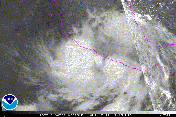
Re: EPAC: INVEST 94E (Remnants of Ernesto)
Latest Loop
0 likes
M a r k
- - - - -
Join us in chat: Storm2K Chatroom Invite. Android and IOS apps also available.
The posts in this forum are NOT official forecasts and should not be used as such. Posts are NOT endorsed by any professional institution or STORM2K.org. For official information and forecasts, please refer to NHC and NWS products.
- - - - -
Join us in chat: Storm2K Chatroom Invite. Android and IOS apps also available.
The posts in this forum are NOT official forecasts and should not be used as such. Posts are NOT endorsed by any professional institution or STORM2K.org. For official information and forecasts, please refer to NHC and NWS products.
-
Weatherguy173

- Tropical Storm

- Posts: 148
- Age: 30
- Joined: Wed Aug 01, 2012 10:55 pm
- Location: Short Hills NJ
Re: EPAC: INVEST 94E (Remnants of Ernesto)
it surely looks like it's getting its act together
0 likes
Nothing I say is intended to be a forecast; it's only food for thought and friendly advice!
-
somethingfunny

- ChatStaff

- Posts: 3926
- Age: 35
- Joined: Thu May 31, 2007 10:30 pm
- Location: McKinney, Texas
Re: EPAC: INVEST 94E (Remnants of Ernesto)
Crossposted from the Ernesto thread...
[img]http://i50.tinypic.com/33064bb.gi f[/img] (.Gif cut out since Tolakram posted the same loop just above)

Check this out... I believe Ernesto's remnant LLC may be located in the middle of Mexico near the blowup of convection around 18.5°N/99°W. But that blowup of convection on the coastline near 18°N/102°W may be a new LLC forming. It's rare to see a loop actually showing the transition here... and it clearly shows why the regenerated system would not be named Ernesto.
Although looking at that loop makes my head spin because there's so many competing circulations. It's definitely related to Ernesto in that regard!

[img]http://i50.tinypic.com/33064bb.gi f[/img] (.Gif cut out since Tolakram posted the same loop just above)
Check this out... I believe Ernesto's remnant LLC may be located in the middle of Mexico near the blowup of convection around 18.5°N/99°W. But that blowup of convection on the coastline near 18°N/102°W may be a new LLC forming. It's rare to see a loop actually showing the transition here... and it clearly shows why the regenerated system would not be named Ernesto.
Although looking at that loop makes my head spin because there's so many competing circulations. It's definitely related to Ernesto in that regard!
0 likes
I am not a meteorologist, and any posts made by me are not official forecasts or to be interpreted as being intelligent. These posts are just my opinions and are probably silly opinions.
-
Yellow Evan

- Professional-Met

- Posts: 15951
- Age: 25
- Joined: Fri Jul 15, 2011 12:48 pm
- Location: Henderson, Nevada/Honolulu, HI
- Contact:
-
hurricanes1234
- Category 5

- Posts: 2903
- Joined: Sat Jul 28, 2012 6:19 pm
- Location: Trinidad and Tobago
Re: EPAC: INVEST 94E (Remnants of Ernesto)
So if this really becomes Hector, in the future will the tropical cyclone be called Hurricane Ernesto-Hector?
Also, does anyone think the remnants of Ernesto will become a hurricane, or even a major hurricane?
________________
The posts in this forum are NOT official forecast and should not be used as such. They are just the opinion of the poster and may or may not be backed by sound meteorological data. They are NOT endorsed by any professional institution or storm2k.org. For official information, please refer to the NHC and NWS products.
0 likes
PLEASE NOTE: With the exception of information from weather agencies that I may copy and paste here, my posts will NEVER be official, since I am NOT a meteorologist. They are solely my amateur opinion, and may or may not be accurate. Therefore, please DO NOT use them as official details, particularly when making important decisions. Thank you.
-
Weatherguy173
- Tropical Storm
- Posts: 148
- Age: 30
- Joined: Wed Aug 01, 2012 10:55 pm
- Location: Short Hills NJ
Re: EPAC: INVEST 94E (Remnants of Ernesto)
hurricanes1234 wrote:So if this really becomes Hector, in the future will the tropical cyclone be called Hurricane Ernesto-Hector?
Also, does anyone think the remnants of 94E will become a hurricane, or even a major hurricane?
what do you mean by "remnants of 94E"? 94E is the remnants of Ernesto (the name of this thread is EPAC: INVEST 94E (Remnants of Ernesto)), it is just designated as an invest because it is not a tropical cyclone and has the potential to develop into one. Please correct me if I am wrong.
0 likes
Nothing I say is intended to be a forecast; it's only food for thought and friendly advice!
-
hurricanes1234
- Category 5
- Posts: 2903
- Joined: Sat Jul 28, 2012 6:19 pm
- Location: Trinidad and Tobago
Re: EPAC: INVEST 94E (Remnants of Ernesto)
I meant Ernesto...sorry. This is the only time I didn't check back my comment and look, there was a major mistake in it. I am very prone to mistakes...just wanted to warn you.
0 likes
PLEASE NOTE: With the exception of information from weather agencies that I may copy and paste here, my posts will NEVER be official, since I am NOT a meteorologist. They are solely my amateur opinion, and may or may not be accurate. Therefore, please DO NOT use them as official details, particularly when making important decisions. Thank you.
-
Weatherguy173
- Tropical Storm
- Posts: 148
- Age: 30
- Joined: Wed Aug 01, 2012 10:55 pm
- Location: Short Hills NJ
Re: EPAC: INVEST 94E (Remnants of Ernesto)
hurricanes1234 wrote:I meant Ernesto...sorry. This is the only time I didn't check back my comment and look, there was a major mistake in it. I am very prone to mistakes...just wanted to warn you.
it's cool
0 likes
Nothing I say is intended to be a forecast; it's only food for thought and friendly advice!
-
hurricanes1234
- Category 5
- Posts: 2903
- Joined: Sat Jul 28, 2012 6:19 pm
- Location: Trinidad and Tobago
Re: EPAC: INVEST 94E (Remnants of Ernesto)
Thanks! 
0 likes
PLEASE NOTE: With the exception of information from weather agencies that I may copy and paste here, my posts will NEVER be official, since I am NOT a meteorologist. They are solely my amateur opinion, and may or may not be accurate. Therefore, please DO NOT use them as official details, particularly when making important decisions. Thank you.
-
cycloneye

- Admin
- Posts: 139025
- Age: 67
- Joined: Thu Oct 10, 2002 10:54 am
- Location: San Juan, Puerto Rico
Re: EPAC: INVEST 94E (Remnants of Ernesto)
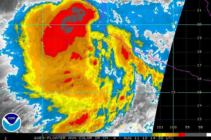
Up to 80%
TROPICAL WEATHER OUTLOOK
NWS NATIONAL HURRICANE CENTER MIAMI FL
500 PM PDT FRI AUG 10 2012
FOR THE EASTERN NORTH PACIFIC...EAST OF 140 DEGREES WEST LONGITUDE..
THE NATIONAL HURRICANE CENTER IS ISSUING ADVISORIES ON TROPICAL
STORM GILMA...LOCATED ABOUT 675 MILES WEST-SOUTHWEST OF THE
SOUTHERN TIP OF BAJA CALIFORNIA.
A LARGE AREA OF SHOWERS AND THUNDERSTORMS CONTINUES ALONG THE
SOUTHWESTERN COAST OF MEXICO...ASSOCIATED WITH THE REMNANTS OF
ERNESTO. ENVIRONMENTAL CONDITIONS ARE FAVORABLE FOR A TROPICAL
DEPRESSION TO FORM DURING THE NEXT DAY OR TWO AS THE DISTURBANCE
MOVES WESTWARD AWAY FROM THE COAST OF MEXICO. THIS SYSTEM HAS A
HIGH CHANCE...80 PERCENT...OF BECOMING A TROPICAL CYCLONE DURING
THE NEXT 48 HOURS.
ELSEWHERE...TROPICAL CYCLONE FORMATION IS NOT EXPECTED DURING THE
NEXT 48 HOURS.
$$
FORECASTER BLAKE
0 likes
Visit the Caribbean-Central America Weather Thread where you can find at first post web cams,radars
and observations from Caribbean basin members Click Here
and observations from Caribbean basin members Click Here
-
cycloneye
- Admin
- Posts: 139025
- Age: 67
- Joined: Thu Oct 10, 2002 10:54 am
- Location: San Juan, Puerto Rico
Re: EPAC: INVEST 94E (Remnants of Ernesto)
00z Best Track
EP, 94, 2012081100, , BEST, 0, 170N, 1030W, 30, 1003, DB
ftp://ftp.nhc.noaa.gov/atcf/tcweb/inves ... 012.invest
EP, 94, 2012081100, , BEST, 0, 170N, 1030W, 30, 1003, DB
ftp://ftp.nhc.noaa.gov/atcf/tcweb/inves ... 012.invest
0 likes
Visit the Caribbean-Central America Weather Thread where you can find at first post web cams,radars
and observations from Caribbean basin members Click Here
and observations from Caribbean basin members Click Here

That'd be cool to have a crossover storm, simply 'cuz crossover storms are really cool.
0 likes
Personal Forecast Disclaimer:
The posts in this forum are NOT official forecast and should not be used as such. They are just the opinion of the poster and may or may not be backed by sound meteorological data. They are NOT endorsed by any professional institution or storm2k.org.
Hope this helped
The posts in this forum are NOT official forecast and should not be used as such. They are just the opinion of the poster and may or may not be backed by sound meteorological data. They are NOT endorsed by any professional institution or storm2k.org.
Hope this helped
-
Hurricane Jed

- Category 2

- Posts: 542
- Age: 36
- Joined: Mon Jan 24, 2011 3:36 pm
- Location: Cen Tex
-
Chickenzilla
- Tropical Storm
- Posts: 109
- Joined: Wed Oct 19, 2011 7:31 am
- Location: Croatia (Southeast Europe)

-
Blown Away

- S2K Supporter

- Posts: 9861
- Joined: Wed May 26, 2004 6:17 am
Re: EPAC: INVEST 94E (Remnants of Ernesto)
This is cool, always amazed with systems that cross over!
0 likes
Hurricane Eye Experience: David 79, Irene 99, Frances 04, Jeanne 04, Wilma 05...
Hurricane Brush Experience: Andrew 92, Erin 95, Floyd 99, Matthew 16, Irma 17, Ian 22, Nicole 22…
Hurricane Brush Experience: Andrew 92, Erin 95, Floyd 99, Matthew 16, Irma 17, Ian 22, Nicole 22…

Re: EPAC: INVEST 94E (Remnants of Ernesto)
This thing is huge! I agree crossover storms are cool. The last time there was some sort of crossover was in 2010 when TD 11E formed in the gulf of Tehuantepec and then it became tropical storm Hermine in the gulf of Mexico.
0 likes
-
Yellow Evan
- Professional-Met
- Posts: 15951
- Age: 25
- Joined: Fri Jul 15, 2011 12:48 pm
- Location: Henderson, Nevada/Honolulu, HI
- Contact:

Who is online
Users browsing this forum: No registered users and 42 guests