WPAC: TEMBIN - Extratropical

Moderator: S2k Moderators

Message
Author
User avatar
euro6208
Category 5
Category 5
Posts: 18547
Joined: Mon Mar 08, 2004 7:50 pm
Location: Guam

Re: WPAC: TEMBIN - Typhoon

#61 Postby euro6208 » Sun Aug 19, 2012 10:36 pm

95 knots but RAW T# is near category 4 strength!

Current Analysis -----
Date : 20 AUG 2012 Time : 023000 UTC
Lat : 18:00:23 N Lon : 124:50:55 E


CI# /Pressure/ Vmax
5.2 / 959.9mb/ 94.8kt


Final T# Adj T# Raw T#
5.2 5.3 5.9

Estimated radius of max. wind based on IR : 24 km

Center Temp : +9.9C Cloud Region Temp : -63.6C

Scene Type : EYE

Positioning Method : RING/SPIRAL COMBINATION

Ocean Basin : WEST PACIFIC
Dvorak CI > MSLP Conversion Used : PACIFIC

Tno/CI Rules : Constraint Limits : 1.7T/6hr
Weakening Flag : OFF
Rapid Dissipation Flag : OFF

C/K/Z MSLP Estimate Inputs :
- Average 34 knot radii : 45km
- Environmental MSLP : 1006mb

Satellite Viewing Angle : 31.2 degrees


Image
0 likes   
Remember, all of my post aren't official. For official warnings and discussions, Please refer to your local NWS products...

NWS for the Western Pacific

https://www.weather.gov/gum/

Typhoon Hunter
WesternPacificWeather.com
Posts: 1215
Age: 40
Joined: Wed Oct 11, 2006 11:37 am
Location: Hong Kong
Contact:

Re: WPAC: TEMBIN - Typhoon

#62 Postby Typhoon Hunter » Sun Aug 19, 2012 10:41 pm

vbhoutex wrote:That is a classic looking typhoon. And as you said, beautiful to look at. Are you heading to Taiwan to intercept it Jim?


Yup most likely tomorrow afternoon, will post updates here. And then Bolaven after that, wherever that beast ends up! :eek:
0 likes   
James - Documenting typhoons...

http://www.youtube.com/TyphoonHunter

User avatar
euro6208
Category 5
Category 5
Posts: 18547
Joined: Mon Mar 08, 2004 7:50 pm
Location: Guam

Re: WPAC: TEMBIN - Typhoon

#63 Postby euro6208 » Sun Aug 19, 2012 10:43 pm

Image

Image

so only a 75 knots category 1? i think not...this is way way stronger...my personal intensity is 110 knots category 3 as the eye isn't fully circular...
0 likes   
Remember, all of my post aren't official. For official warnings and discussions, Please refer to your local NWS products...

NWS for the Western Pacific

https://www.weather.gov/gum/

Meow

Re: WPAC: TEMBIN - Typhoon

#64 Postby Meow » Sun Aug 19, 2012 10:56 pm

Typhoon Hunter wrote:Yup most likely tomorrow afternoon, will post updates here. And then Bolaven after that, wherever that beast ends up! :eek:

Maybe you have to stay in Taiwan for a week, for two typhoons. :double:
0 likes   

phwxenthusiast
Category 2
Category 2
Posts: 637
Joined: Wed Mar 24, 2010 3:10 am
Location: Holbrook, NY (Long Island)

Re: WPAC: TEMBIN - Tropical Storm

#65 Postby phwxenthusiast » Sun Aug 19, 2012 11:09 pm

Typhoon Hunter wrote:I grabbed this from the China typhoon web forum, it would appear to be a pro-ECMWF chart showing Tembin reaching disturbingly high level of intensity prior to landfall on Taiwan!

Image

Uploaded with ImageShack.us


that is from Wunderground.. and no since the winds are shown in Kts so that would be around 70kts--not a STY??:) this data is easily accessible and contains both ECMWF and GFS data... i'm quite surprised the ECMWF continues to be available in their site since most euro products are usually not allowed to be reproduced or something...

anyway i am surprised that PAGASA is keeping this at 105kph TS?!?! :double:

as for the strength, the only thing that i'm "worried" about is if the eyewall continues to contract and chokes... right now, the eye diameter is around 10 nm..

Personal Forecast Disclaimer:
The posts in this forum are NOT official forecast and should not be used as such. They are just the opinion of the poster and may or may not be backed by sound meteorological data. They are NOT endorsed by any professional institution or storm2k.org. For official information, please refer to the NHC and NWS products.
0 likes   

User avatar
euro6208
Category 5
Category 5
Posts: 18547
Joined: Mon Mar 08, 2004 7:50 pm
Location: Guam

Re: WPAC: TEMBIN - Typhoon

#66 Postby euro6208 » Sun Aug 19, 2012 11:17 pm

THE CURRENT INTENSITY IS BASED ON DVORAK ESTIMATES OF 65
TO 77 KNOTS FROM RJTD/KNES, AND PGTW RESPECTIVELY.

why don't they use estimates from cimss which is in real-time? already near 100 knots or more...


CI# /Pressure/ Vmax
5.3 / 957.9mb/ 97.2kt


Final T# Adj T# Raw T#
5.3 5.6 5.8
0 likes   
Remember, all of my post aren't official. For official warnings and discussions, Please refer to your local NWS products...

NWS for the Western Pacific

https://www.weather.gov/gum/

User avatar
euro6208
Category 5
Category 5
Posts: 18547
Joined: Mon Mar 08, 2004 7:50 pm
Location: Guam

Re: WPAC: TEMBIN - Typhoon

#67 Postby euro6208 » Mon Aug 20, 2012 12:32 am

Image

how strong do you think tembin is?
0 likes   
Remember, all of my post aren't official. For official warnings and discussions, Please refer to your local NWS products...

NWS for the Western Pacific

https://www.weather.gov/gum/

shyamvk
Tropical Low
Tropical Low
Posts: 12
Joined: Mon Aug 13, 2012 11:29 pm

Re: WPAC: TEMBIN - Typhoon

#68 Postby shyamvk » Mon Aug 20, 2012 12:52 am

is it expected to hit Hong Kong Badly?
0 likes   

shyamvk
Tropical Low
Tropical Low
Posts: 12
Joined: Mon Aug 13, 2012 11:29 pm

Re: WPAC: TEMBIN - Typhoon

#69 Postby shyamvk » Mon Aug 20, 2012 12:53 am

Thanks
0 likes   

Typhoon Hunter
WesternPacificWeather.com
Posts: 1215
Age: 40
Joined: Wed Oct 11, 2006 11:37 am
Location: Hong Kong
Contact:

Re: WPAC: TEMBIN - Typhoon

#70 Postby Typhoon Hunter » Mon Aug 20, 2012 12:56 am

Pat thanks for clarifying that chart for me, sorry for any confusion or undue alarm.
0 likes   
James - Documenting typhoons...

http://www.youtube.com/TyphoonHunter

madness
Tropical Low
Tropical Low
Posts: 41
Joined: Sat Jul 30, 2011 11:23 pm
Location: Brisbane, Australia

Re: WPAC: TEMBIN - Typhoon

#71 Postby madness » Mon Aug 20, 2012 1:57 am

shyamvk wrote:is it expected to hit Hong Kong Badly?


First landfall will be in eastern Taiwan, probably as a category 4 system
Second landfall could be somewhere in eastern Guangdong Province (east of Hong Kong) possibly Shantou
But, it is far too early to be guessing what the impact on China will be
0 likes   

Meow

Re: WPAC: TEMBIN - Typhoon

#72 Postby Meow » Mon Aug 20, 2012 2:01 am

JMA: 80 knots

Image

TY 1214 (TEMBIN)
Issued at 06:45 UTC, 20 August 2012

<Analyses at 20/06 UTC>
Scale -
Intensity Strong
Center position N18°25'(18.4°)
E124°55'(124.9°)
Direction and speed of movement N Slowly
Central pressure 960hPa
Maximum wind speed near the center 40m/s(80kt)
Maximum wind gust speed 60m/s(115kt)
Area of 50kt winds or more ALL80km(45NM)
Area of 30kt winds or more ALL330km(180NM)

<Forecast for 21/06 UTC>
Intensity Very Strong
Center position of probability circle N21°05'(21.1°)
E125°55'(125.9°)
Direction and speed of movement NNE 15km/h(7kt)
Central pressure 945hPa
Maximum wind speed near the center 45m/s(85kt)
Maximum wind gust speed 60m/s(120kt)
Radius of probability circle 160km(85NM)
Storm warning area ALL280km(150NM)

<Forecast for 22/06 UTC>
Intensity Very Strong
Center position of probability circle N23°20'(23.3°)
E124°10'(124.2°)
Direction and speed of movement NW 15km/h(7kt)
Central pressure 940hPa
Maximum wind speed near the center 45m/s(90kt)
Maximum wind gust speed 65m/s(130kt)
Radius of probability circle 200km(110NM)
Storm warning area ALL350km(190NM)

<Forecast for 23/06 UTC>
Intensity Very Strong
Center position of probability circle N24°05'(24.1°)
E121°50'(121.8°)
Direction and speed of movement WNW 10km/h(6kt)
Central pressure 940hPa
Maximum wind speed near the center 45m/s(90kt)
Maximum wind gust speed 65m/s(130kt)
Radius of probability circle 300km(160NM)
Storm warning area ALL440km(240NM)
0 likes   

User avatar
mrbagyo
Category 5
Category 5
Posts: 3614
Age: 31
Joined: Thu Apr 12, 2012 9:18 am
Location: 14.13N 120.98E
Contact:

Re: WPAC: TEMBIN - Typhoon

#73 Postby mrbagyo » Mon Aug 20, 2012 2:28 am

PAGASA still has it at 105 kph...but they might upgrade this to typhoon in their next advisory
0 likes   
The posts in this forum are NOT official forecast and should not be used as such. They are just the opinion of the poster and may or may not be backed by sound meteorological data. They are NOT endorsed by any professional institution or storm2k.org. For official information, please refer to RSMC, NHC and NWS products.

User avatar
mrbagyo
Category 5
Category 5
Posts: 3614
Age: 31
Joined: Thu Apr 12, 2012 9:18 am
Location: 14.13N 120.98E
Contact:

Re: WPAC: TEMBIN - Typhoon

#74 Postby mrbagyo » Mon Aug 20, 2012 4:07 am

its now 95 knots!!! and to peak at 120 knots!

WTPN31 PGTW 200900
MSGID/GENADMIN/JOINT TYPHOON WRNCEN PEARL HARBOR HI//
SUBJ/TROPICAL CYCLONE WARNING//
RMKS/
1. TYPHOON 15W (TEMBIN) WARNING NR 006
02 ACTIVE TROPICAL CYCLONES IN NORTHWESTPAC
MAX SUSTAINED WINDS BASED ON ONE-MINUTE AVERAGE
WIND RADII VALID OVER OPEN WATER ONLY
---
WARNING POSITION:
200600Z --- NEAR 18.4N 124.9E
MOVEMENT PAST SIX HOURS - 015 DEGREES AT 04 KTS
POSITION ACCURATE TO WITHIN 020 NM
POSITION BASED ON EYE FIXED BY SATELLITE
PRESENT WIND DISTRIBUTION:
MAX SUSTAINED WINDS - 095 KT, GUSTS 115 KT
WIND RADII VALID OVER OPEN WATER ONLY
RADIUS OF 064 KT WINDS - 030 NM NORTHEAST QUADRANT
030 NM SOUTHEAST QUADRANT
030 NM SOUTHWEST QUADRANT
030 NM NORTHWEST QUADRANT
RADIUS OF 050 KT WINDS - 050 NM NORTHEAST QUADRANT
050 NM SOUTHEAST QUADRANT
050 NM SOUTHWEST QUADRANT
050 NM NORTHWEST QUADRANT
RADIUS OF 034 KT WINDS - 085 NM NORTHEAST QUADRANT
085 NM SOUTHEAST QUADRANT
085 NM SOUTHWEST QUADRANT
085 NM NORTHWEST QUADRANT
REPEAT POSIT: 18.4N 124.9E
---
FORECASTS:
12 HRS, VALID AT:
201800Z --- 19.6N 125.0E
MAX SUSTAINED WINDS - 105 KT, GUSTS 130 KT
WIND RADII VALID OVER OPEN WATER ONLY
RADIUS OF 064 KT WINDS - 035 NM NORTHEAST QUADRANT
035 NM SOUTHEAST QUADRANT
035 NM SOUTHWEST QUADRANT
035 NM NORTHWEST QUADRANT
RADIUS OF 050 KT WINDS - 055 NM NORTHEAST QUADRANT
055 NM SOUTHEAST QUADRANT
055 NM SOUTHWEST QUADRANT
055 NM NORTHWEST QUADRANT
RADIUS OF 034 KT WINDS - 100 NM NORTHEAST QUADRANT
100 NM SOUTHEAST QUADRANT
100 NM SOUTHWEST QUADRANT
100 NM NORTHWEST QUADRANT
VECTOR TO 24 HR POSIT: 360 DEG/ 06 KTS
---
24 HRS, VALID AT:
210600Z --- 20.9N 125.0E
MAX SUSTAINED WINDS - 115 KT, GUSTS 140 KT
WIND RADII VALID OVER OPEN WATER ONLY
RADIUS OF 064 KT WINDS - 040 NM NORTHEAST QUADRANT
040 NM SOUTHEAST QUADRANT
040 NM SOUTHWEST QUADRANT
040 NM NORTHWEST QUADRANT
RADIUS OF 050 KT WINDS - 065 NM NORTHEAST QUADRANT
065 NM SOUTHEAST QUADRANT
065 NM SOUTHWEST QUADRANT
065 NM NORTHWEST QUADRANT
RADIUS OF 034 KT WINDS - 110 NM NORTHEAST QUADRANT
110 NM SOUTHEAST QUADRANT
110 NM SOUTHWEST QUADRANT
110 NM NORTHWEST QUADRANT
VECTOR TO 36 HR POSIT: 335 DEG/ 06 KTS
---
36 HRS, VALID AT:
211800Z --- 22.0N 124.5E
MAX SUSTAINED WINDS - 120 KT, GUSTS 145 KT
WIND RADII VALID OVER OPEN WATER ONLY
RADIUS OF 064 KT WINDS - 040 NM NORTHEAST QUADRANT
040 NM SOUTHEAST QUADRANT
040 NM SOUTHWEST QUADRANT
040 NM NORTHWEST QUADRANT
RADIUS OF 050 KT WINDS - 065 NM NORTHEAST QUADRANT
065 NM SOUTHEAST QUADRANT
065 NM SOUTHWEST QUADRANT
065 NM NORTHWEST QUADRANT
RADIUS OF 034 KT WINDS - 120 NM NORTHEAST QUADRANT
115 NM SOUTHEAST QUADRANT
115 NM SOUTHWEST QUADRANT
120 NM NORTHWEST QUADRANT
VECTOR TO 48 HR POSIT: 305 DEG/ 05 KTS
---
EXTENDED OUTLOOK:
48 HRS, VALID AT:
220600Z --- 22.6N 123.6E
MAX SUSTAINED WINDS - 120 KT, GUSTS 145 KT
WIND RADII VALID OVER OPEN WATER ONLY
RADIUS OF 064 KT WINDS - 040 NM NORTHEAST QUADRANT
040 NM SOUTHEAST QUADRANT
040 NM SOUTHWEST QUADRANT
040 NM NORTHWEST QUADRANT
RADIUS OF 050 KT WINDS - 070 NM NORTHEAST QUADRANT
070 NM SOUTHEAST QUADRANT
070 NM SOUTHWEST QUADRANT
070 NM NORTHWEST QUADRANT
RADIUS OF 034 KT WINDS - 125 NM NORTHEAST QUADRANT
120 NM SOUTHEAST QUADRANT
120 NM SOUTHWEST QUADRANT
125 NM NORTHWEST QUADRANT
VECTOR TO 72 HR POSIT: 285 DEG/ 06 KTS
---
72 HRS, VALID AT:
230600Z --- 23.3N 120.9E
MAX SUSTAINED WINDS - 105 KT, GUSTS 130 KT
WIND RADII VALID OVER OPEN WATER ONLY
VECTOR TO 96 HR POSIT: 270 DEG/ 08 KTS
---
LONG RANGE OUTLOOK:
---
96 HRS, VALID AT:
240600Z --- 23.3N 117.5E
MAX SUSTAINED WINDS - 070 KT, GUSTS 085 KT
WIND RADII VALID OVER OPEN WATER ONLY
VECTOR TO 120 HR POSIT: 270 DEG/ 09 KTS
---
120 HRS, VALID AT:
250600Z --- 23.4N 113.6E
MAX SUSTAINED WINDS - 050 KT, GUSTS 065 KT
WIND RADII VALID OVER OPEN WATER ONLY
DISSIPATING AS A SIGNIFICANT TROPICAL CYCLONE OVER LAND
---
REMARKS:
200900Z POSITION NEAR 18.7N 124.9E.
TYPHOON 15W (TEMBIN), LOCATED APPROXIMATELY 320 NM NORTHEAST
OF MANILA, PHILIPPINES, HAS TRACKED NORTH-NORTHEASTWARD AT
04 KNOTS OVER THE PAST SIX HOURS. MAXIMUM SIGNIFICANT WAVE
HEIGHT AT 200600Z IS 20 FEET. NEXT WARNINGS AT 201500Z,
202100Z, 210300Z AND 210900Z. REFER TO TROPICAL STORM
16W (BOLAVEN) WARNINGS (WTPN32 PGTW) FOR SIX-HOURLY
UPDATES.//
NNNN
0 likes   
The posts in this forum are NOT official forecast and should not be used as such. They are just the opinion of the poster and may or may not be backed by sound meteorological data. They are NOT endorsed by any professional institution or storm2k.org. For official information, please refer to RSMC, NHC and NWS products.

shyamvk
Tropical Low
Tropical Low
Posts: 12
Joined: Mon Aug 13, 2012 11:29 pm

Re: WPAC: TEMBIN - Typhoon

#75 Postby shyamvk » Mon Aug 20, 2012 4:14 am

120 hours , if it makes landfall. Any guesses, where it would be?
0 likes   

Typhoon Hunter
WesternPacificWeather.com
Posts: 1215
Age: 40
Joined: Wed Oct 11, 2006 11:37 am
Location: Hong Kong
Contact:

Re: WPAC: TEMBIN - Typhoon

#76 Postby Typhoon Hunter » Mon Aug 20, 2012 4:19 am

shyamvk wrote:120 hours , if it makes landfall. Any guesses, where it would be?


Here are links to the Japanese Meteorological Agency forecast track: http://www.jma.go.jp/en/typh/1214.html

Tropical Storm Risk, which uses Joint Typhoon Warning Centre data (you can't access JTWC in HK without a proxy): http://tropicalstormrisk.com/

And finally HK Observatory forecast: http://www.weather.gov.hk/wxinfo/currwx/tc_gis_e.htm

You can consult these very useful links to get a good idea yourself where the storm is forecast to hit by three of the regions' top forecast centres.
0 likes   
James - Documenting typhoons...

http://www.youtube.com/TyphoonHunter

Typhoon Hunter
WesternPacificWeather.com
Posts: 1215
Age: 40
Joined: Wed Oct 11, 2006 11:37 am
Location: Hong Kong
Contact:

Re: WPAC: TEMBIN - Typhoon

#77 Postby Typhoon Hunter » Mon Aug 20, 2012 7:12 am

Looks to be strengthening even further now, raw Dvorak at T6.4 and colour satellite imagery shows one heck of a powerful storm. Already a solid cat. 4 in my opinion! I expect JTWC to have this at 115-120kts in the next update out in about 1 hour.

Personal Forecast Disclaimer:
The posts in this forum are NOT official forecast and should not be used as such. They are just the opinion of the poster and may or may not be backed by sound meteorological data. They are NOT endorsed by any professional institution or storm2k.org. For official information, please refer to the JMA and local government products.
0 likes   
James - Documenting typhoons...

http://www.youtube.com/TyphoonHunter

tolakram
Admin
Admin
Posts: 19165
Age: 60
Joined: Sun Aug 27, 2006 8:23 pm
Location: Florence, KY (name is Mark)

Re: WPAC: TEMBIN - Typhoon

#78 Postby tolakram » Mon Aug 20, 2012 7:19 am

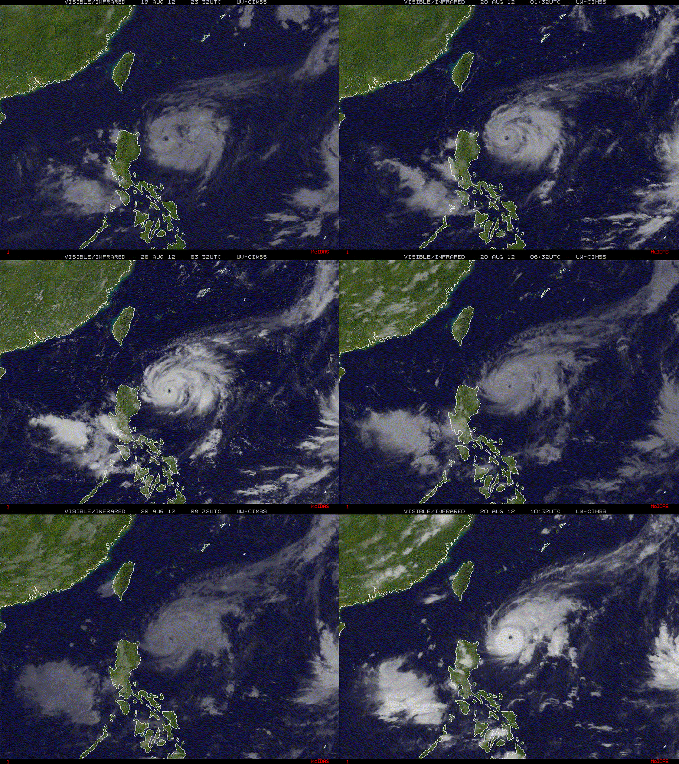
Latest Saved Loop

Image

from: http://tropic.ssec.wisc.edu
0 likes   
M a r k
- - - - -
Join us in chat: Storm2K Chatroom Invite. Android and IOS apps also available.

The posts in this forum are NOT official forecasts and should not be used as such. Posts are NOT endorsed by any professional institution or STORM2K.org. For official information and forecasts, please refer to NHC and NWS products.

User avatar
mrbagyo
Category 5
Category 5
Posts: 3614
Age: 31
Joined: Thu Apr 12, 2012 9:18 am
Location: 14.13N 120.98E
Contact:

Re: WPAC: TEMBIN - Typhoon

#79 Postby mrbagyo » Mon Aug 20, 2012 8:43 am

0 likes   
The posts in this forum are NOT official forecast and should not be used as such. They are just the opinion of the poster and may or may not be backed by sound meteorological data. They are NOT endorsed by any professional institution or storm2k.org. For official information, please refer to RSMC, NHC and NWS products.

User avatar
mrbagyo
Category 5
Category 5
Posts: 3614
Age: 31
Joined: Thu Apr 12, 2012 9:18 am
Location: 14.13N 120.98E
Contact:

Re: WPAC: TEMBIN - Typhoon

#80 Postby mrbagyo » Mon Aug 20, 2012 8:54 am

UW - CIMSS
ADVANCED DVORAK TECHNIQUE
ADT-Version 8.1.3
Tropical Cyclone Intensity Algorithm

----- Current Analysis -----
Date : 20 AUG 2012 Time : 130000 UTC
Lat : 19:02:45 N Lon : 125:12:02 E


CI# /Pressure/ Vmax
6.1 / 941.8mb/117.4kt


Final T# Adj T# Raw T#
6.1 6.0 6.0


Estimated radius of max. wind based on IR :N/A km

Center Temp : -13.0C Cloud Region Temp : -69.8C

Scene Type : EYE

Positioning Method : RING/SPIRAL COMBINATION

Ocean Basin : WEST PACIFIC
Dvorak CI > MSLP Conversion Used : PACIFIC

Tno/CI Rules : Constraint Limits : NO LIMIT
Weakening Flag : OFF
Rapid Dissipation Flag : OFF

C/K/Z MSLP Estimate Inputs :
- Average 34 knot radii : 90km
- Environmental MSLP : 1007mb

Satellite Viewing Angle : 31.7 degrees
0 likes   
The posts in this forum are NOT official forecast and should not be used as such. They are just the opinion of the poster and may or may not be backed by sound meteorological data. They are NOT endorsed by any professional institution or storm2k.org. For official information, please refer to RSMC, NHC and NWS products.


Return to “2012”

Who is online

Users browsing this forum: No registered users and 36 guests