ATL: ISAAC - Post-Tropical - Discussion
Moderator: S2k Moderators

Re: ATL: INVEST 94L
Since 1851 according to the NHC there have been 12 systems that have passed within 5 degrees of the current 94L in the month of August. Of the 12 , 1 has reached the U.S. coastline , in 1933 making landfall along the North Carolina , Virginia border. Therefore , statistically speaking , this system would have a 1 in 12 chance , or 8.3 % chance of making it to the U.S. As for the Caribbean , 0 have made it into the area. Therefore , statistically speaking . this system has a 0 in 12 chance , or 0 % of making it to the Caribbean. Interestingly enough , if the system remains at the same latitiude 5 degrees further west , of the 16 systems , 3 make landfall in the U.S. , with a 4th in Mexico. 1915 had a storm strike the upper Texas coast , again 1933 in the mid-Atlantic , 1981 Dennis in south Florida , and 2007 with Dean into the Yucatan and southern Mexico.
0 likes
-
CrazyC83
- Professional-Met

- Posts: 33393
- Joined: Tue Mar 07, 2006 11:57 pm
- Location: Deep South, for the first time!
Re: ATL: INVEST 94L
hcane27 wrote:Since 1851 according to the NHC there have been 12 systems that have passed within 5 degrees of the current 94L in the month of August. Of the 12 , 1 has reached the U.S. coastline , in 1933 making landfall along the North Carolina , Virginia border. Therefore , statistically speaking , this system would have a 1 in 12 chance , or 8.3 % chance of making it to the U.S. As for the Caribbean , 0 have made it into the area. Therefore , statistically speaking . this system has a 0 in 12 chance , or 0 % of making it to the Caribbean. Interestingly enough , if the system remains at the same latitiude 5 degrees further west , of the 16 systems , 3 make landfall in the U.S. , with a 4th in Mexico. 1915 had a storm strike the upper Texas coast , again 1933 in the mid-Atlantic , 1981 Dennis in south Florida , and 2007 with Dean into the Yucatan and southern Mexico.
What about in September? With this troughing this is more reminiscent of an early fall pattern.
0 likes
-
Aric Dunn
- Category 5

- Posts: 21228
- Age: 41
- Joined: Sun Sep 19, 2004 9:58 pm
- Location: Ready for the Chase.
- Contact:
Re: ATL: INVEST 94L
tolakram wrote:saved loop
from: http://tropic.ssec.wisc.edu/#
Click on the I for the invest, select VIS/SWIR and click the ANIGIF button to animate the image. Once working click the capture button at the top, which will generate an animated GIF you can save and upload to imageshack (or the image server of your choice) to display here.
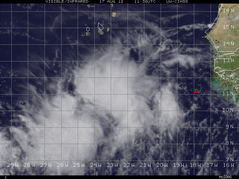
There seems to be two circs. one up at 11 to 12 north and the other down around 9 north the overall alrger circ is tilted ne to sw and depending on which one takes over will help determine when and if it re-curves fully. So far this the elongation and double low scenario is dead on with the GFS>
0 likes
Note: If I make a post that is brief. Please refer back to previous posts for the analysis or reasoning. I do not re-write/qoute what my initial post said each time.
If there is nothing before... then just ask
Space & Atmospheric Physicist, Embry-Riddle Aeronautical University,
I believe the sky is falling...
If there is nothing before... then just ask
Space & Atmospheric Physicist, Embry-Riddle Aeronautical University,
I believe the sky is falling...
-
HurricaneAndrew92
Re: ATL: INVEST 94L
CrazyC83 wrote:HurricaneAndrew92 wrote:I honestly want to watch this, I live on the east coast. Would say a 20-30 at 2. Would love to see my first hurricane in over 20 years.
What was your last hurricane?
I agree on those probabilities. Being so far from land, they can be more conservative, unlike with ex-TD7 which they would have to upgrade immediately.
It was Bob, but I don't rember much because I was young.
0 likes
-
Blown Away

- S2K Supporter

- Posts: 9861
- Joined: Wed May 26, 2004 6:17 am
Re: ATL: INVEST 94L
hcane27 wrote:Since 1851 according to the NHC there have been 12 systems that have passed within 5 degrees of the current 94L in the month of August. Of the 12 , 1 has reached the U.S. coastline , in 1933 making landfall along the North Carolina , Virginia border. Therefore , statistically speaking , this system would have a 1 in 12 chance , or 8.3 % chance of making it to the U.S. As for the Caribbean , 0 have made it into the area. Therefore , statistically speaking . this system has a 0 in 12 chance , or 0 % of making it to the Caribbean. Interestingly enough , if the system remains at the same latitiude 5 degrees further west , of the 16 systems , 3 make landfall in the U.S. , with a 4th in Mexico. 1915 had a storm strike the upper Texas coast , again 1933 in the mid-Atlantic , 1981 Dennis in south Florida , and 2007 with Dean into the Yucatan and southern Mexico.
Are the stats based on developed TD's or TS at 94's position? If yes, likely many recurves in eastern Atlantic. If 94L takes longer to deepen it will move westerly and the impact chances increase.
0 likes
Hurricane Eye Experience: David 79, Irene 99, Frances 04, Jeanne 04, Wilma 05...
Hurricane Brush Experience: Andrew 92, Erin 95, Floyd 99, Matthew 16, Irma 17, Ian 22, Nicole 22…
Hurricane Brush Experience: Andrew 92, Erin 95, Floyd 99, Matthew 16, Irma 17, Ian 22, Nicole 22…
-
Hurricane Andrew

- S2K Supporter
- Posts: 1891
- Age: 25
- Joined: Sun May 23, 2010 2:53 pm
- Location: KS
-
Aric Dunn
- Category 5
- Posts: 21228
- Age: 41
- Joined: Sun Sep 19, 2004 9:58 pm
- Location: Ready for the Chase.
- Contact:
Re:
Hurricane Andrew wrote:Which circulation center does the GFS have dominating?
hard to say but it looks like the northern one for the GFS. but right now the southern one looks better. we will have to wait .
0 likes
Note: If I make a post that is brief. Please refer back to previous posts for the analysis or reasoning. I do not re-write/qoute what my initial post said each time.
If there is nothing before... then just ask
Space & Atmospheric Physicist, Embry-Riddle Aeronautical University,
I believe the sky is falling...
If there is nothing before... then just ask
Space & Atmospheric Physicist, Embry-Riddle Aeronautical University,
I believe the sky is falling...

Yes Aric I was going to say, clearly two circulations there on that loop. That isn't going to help it strengthening quickly, I've seen systems really struggle with this sort of set-up in the past.
Moving at a decent rate as well, 17kts. Not stupidly fast but I'd guess faster than the models bar the ECM are suggesting at the moment.
ps, interesting stats, but they are likely for systems that have developed within 5 degrees of this system, this one could just as easily form at 25W as 40W at the moment.
Whatever troubles this one has with regards to inner structure, I think its going to be a very pretty looking hurricane by this time next week!
0 likes
Personal Forecast Disclaimer:
The posts in this forum are NOT official forecast and should not be used as such. They are just the opinion of the poster and may or may not be backed by sound meteorological data. They are NOT endorsed by any professional institution or storm2k.org. For official information, please refer to the NHC and NWS products
The posts in this forum are NOT official forecast and should not be used as such. They are just the opinion of the poster and may or may not be backed by sound meteorological data. They are NOT endorsed by any professional institution or storm2k.org. For official information, please refer to the NHC and NWS products
-
Blown Away
- S2K Supporter
- Posts: 9861
- Joined: Wed May 26, 2004 6:17 am
Re: ATL: INVEST 94L
Agree, I am hopeful we see a classic 3/4 CV hurricane churning across the Atlantic!
0 likes
Hurricane Eye Experience: David 79, Irene 99, Frances 04, Jeanne 04, Wilma 05...
Hurricane Brush Experience: Andrew 92, Erin 95, Floyd 99, Matthew 16, Irma 17, Ian 22, Nicole 22…
Hurricane Brush Experience: Andrew 92, Erin 95, Floyd 99, Matthew 16, Irma 17, Ian 22, Nicole 22…
Re: ATL: INVEST 94L
Blown Away wrote:hcane27 wrote:Since 1851 according to the NHC there have been 12 systems that have passed within 5 degrees of the current 94L in the month of August. Of the 12 , 1 has reached the U.S. coastline , in 1933 making landfall along the North Carolina , Virginia border. Therefore , statistically speaking , this system would have a 1 in 12 chance , or 8.3 % chance of making it to the U.S. As for the Caribbean , 0 have made it into the area. Therefore , statistically speaking . this system has a 0 in 12 chance , or 0 % of making it to the Caribbean. Interestingly enough , if the system remains at the same latitiude 5 degrees further west , of the 16 systems , 3 make landfall in the U.S. , with a 4th in Mexico. 1915 had a storm strike the upper Texas coast , again 1933 in the mid-Atlantic , 1981 Dennis in south Florida , and 2007 with Dean into the Yucatan and southern Mexico.
Are the stats based on developed TD's or TS at 94's position? If yes, likely many recurves in eastern Atlantic. If 94L takes longer to deepen it will move westerly and the impact chances increase.
The systems referenced are those that gained at least TD status. I apologize for having left that out.
0 likes
-
Aric Dunn
- Category 5
- Posts: 21228
- Age: 41
- Joined: Sun Sep 19, 2004 9:58 pm
- Location: Ready for the Chase.
- Contact:
Re:
KWT wrote:Yes Aric I was going to say, clearly two circulations there on that loop. That isn't going to help it strengthening quickly, I've seen systems really struggle with this sort of set-up in the past.
Moving at a decent rate as well, 17kts. Not stupidly fast but I'd guess faster than the models bar the ECM are suggesting at the moment.
ps, interesting stats, but they are likely for systems that have developed within 5 degrees of this system, this one could just as easily form at 25W as 40W at the moment.
Whatever troubles this one has with regards to inner structure, I think its going to be a very pretty looking hurricane by this time next week!
yeah environment seems good for a hurricane.
RAMMB has the floater up now its looking very impressive.

0 likes
Note: If I make a post that is brief. Please refer back to previous posts for the analysis or reasoning. I do not re-write/qoute what my initial post said each time.
If there is nothing before... then just ask
Space & Atmospheric Physicist, Embry-Riddle Aeronautical University,
I believe the sky is falling...
If there is nothing before... then just ask
Space & Atmospheric Physicist, Embry-Riddle Aeronautical University,
I believe the sky is falling...
Hmmm the lower circulation does look stronger but its within the ITCZ from the looks of things, really needs to detatch itself. It does look good though thats for sure!
0 likes
Personal Forecast Disclaimer:
The posts in this forum are NOT official forecast and should not be used as such. They are just the opinion of the poster and may or may not be backed by sound meteorological data. They are NOT endorsed by any professional institution or storm2k.org. For official information, please refer to the NHC and NWS products
The posts in this forum are NOT official forecast and should not be used as such. They are just the opinion of the poster and may or may not be backed by sound meteorological data. They are NOT endorsed by any professional institution or storm2k.org. For official information, please refer to the NHC and NWS products
-
cycloneye

- Admin

- Posts: 139011
- Age: 67
- Joined: Thu Oct 10, 2002 10:54 am
- Location: San Juan, Puerto Rico
Re: ATL: INVEST 94L
This morning's discussion of 94L by Dr Jeff Masters.
94L developing off the coast of Africa
A large tropical wave emerged from the coast of Africa Thursday night, and was designated Invest 94L by NHC this Friday morning. The models have been very gung-ho on this system, and develop it into a tropical storm by the middle of next week. 94L will follow a west to west-northwest track over the next week, and may threaten the northern Lesser Antilles Islands as early as Friday, August 24. This storm could eventually affect Bermuda, the U.S. East Coast, or Canada 10 - 14 days from now, but could also recurve harmlessly out to sea well before reaching the Lesser Antilles, as suggested by the 00 UTC run of the GFS model. In their 8 am EDT Tropical Weather Outlook, NHC gave 94L a 10% chance of developing into a tropical depression by Sunday morning.
0 likes
Visit the Caribbean-Central America Weather Thread where you can find at first post web cams,radars
and observations from Caribbean basin members Click Here
and observations from Caribbean basin members Click Here
Dr.Jeff has made a very sound and solid look at the system and really trhat part about where the system will go sort of covers it.
Sometimes you can be pretty confident about the track of a system and whether it recurves, but I'm not at all sure about this one, there is a weakness present but the set-up isn't screaming recurve, its just 'whispering' it instead!
Sometimes you can be pretty confident about the track of a system and whether it recurves, but I'm not at all sure about this one, there is a weakness present but the set-up isn't screaming recurve, its just 'whispering' it instead!
0 likes
Personal Forecast Disclaimer:
The posts in this forum are NOT official forecast and should not be used as such. They are just the opinion of the poster and may or may not be backed by sound meteorological data. They are NOT endorsed by any professional institution or storm2k.org. For official information, please refer to the NHC and NWS products
The posts in this forum are NOT official forecast and should not be used as such. They are just the opinion of the poster and may or may not be backed by sound meteorological data. They are NOT endorsed by any professional institution or storm2k.org. For official information, please refer to the NHC and NWS products
Re: ATL: INVEST 94L
I hate 'whispering' campaigns as I live on Anguilla. A FISH much better! 
0 likes
I wonder where they are going to place the center of this system, I suspect for now they will go with a halfway house between the 2 centers until one becomes established.
0 likes
Personal Forecast Disclaimer:
The posts in this forum are NOT official forecast and should not be used as such. They are just the opinion of the poster and may or may not be backed by sound meteorological data. They are NOT endorsed by any professional institution or storm2k.org. For official information, please refer to the NHC and NWS products
The posts in this forum are NOT official forecast and should not be used as such. They are just the opinion of the poster and may or may not be backed by sound meteorological data. They are NOT endorsed by any professional institution or storm2k.org. For official information, please refer to the NHC and NWS products
-
cycloneye
- Admin
- Posts: 139011
- Age: 67
- Joined: Thu Oct 10, 2002 10:54 am
- Location: San Juan, Puerto Rico
Re: ATL: INVEST 94L
Jimsot wrote:I hate 'whispering' campaigns as I live on Anguilla. A FISH much better!
I dont like this one a bit for us in the NE Caribbean islands as the models have been trending more west with every run,but more important is the more time the system doesn't get very strong,the more west it tracks so we have to watch very closely what is going on.
0 likes
Visit the Caribbean-Central America Weather Thread where you can find at first post web cams,radars
and observations from Caribbean basin members Click Here
and observations from Caribbean basin members Click Here
There is a weakness present so I think its more likely than not that it gets far enough north to avoid the Ne.Caribbean...but no doubt that the trend thus far has been to the west.
Models have been getting quicker with the flow to the wes, that would be suggestive that the upper high is a little stronger than the models were firstly predicting.
I think it'll at least get past 60W at some point, so its going to come close to either the NE Caribbean or Bermuda.
Models have been getting quicker with the flow to the wes, that would be suggestive that the upper high is a little stronger than the models were firstly predicting.
I think it'll at least get past 60W at some point, so its going to come close to either the NE Caribbean or Bermuda.
0 likes
Personal Forecast Disclaimer:
The posts in this forum are NOT official forecast and should not be used as such. They are just the opinion of the poster and may or may not be backed by sound meteorological data. They are NOT endorsed by any professional institution or storm2k.org. For official information, please refer to the NHC and NWS products
The posts in this forum are NOT official forecast and should not be used as such. They are just the opinion of the poster and may or may not be backed by sound meteorological data. They are NOT endorsed by any professional institution or storm2k.org. For official information, please refer to the NHC and NWS products
-
Blown Away
- S2K Supporter
- Posts: 9861
- Joined: Wed May 26, 2004 6:17 am
Re: ATL: INVEST 94L
Majority of the classic hurricanes that have affected the NE Caribbean, Bahamas, and CONUS started where 94L is moved west across Atlantic, find weakness approaching the islands, begin moving WNW to NW but don't gain enough latitude to recurve, and get pushed back WNW under a building ridge. Fortunately most follow a recurve track being advertised by GFS. The latest Euro teased us a little ending it's run bending back WNW after making that NW movement near the islands.
0 likes
Hurricane Eye Experience: David 79, Irene 99, Frances 04, Jeanne 04, Wilma 05...
Hurricane Brush Experience: Andrew 92, Erin 95, Floyd 99, Matthew 16, Irma 17, Ian 22, Nicole 22…
Hurricane Brush Experience: Andrew 92, Erin 95, Floyd 99, Matthew 16, Irma 17, Ian 22, Nicole 22…
Re: ATL: INVEST 94L
I think it'll at least get past 60W at some point, so its going to come close to either the NE Caribbean or Bermuda.
August 2010's Earl was predicted to recurve on the initial forecast track(s) but just kept going west until BAM we were under Hurricane warnings on Anguilla. It didn't turn fast enough.
0 likes
Who is online
Users browsing this forum: No registered users and 13 guests