000
AXNT20 KNHC 211149
TWDAT
TROPICAL WEATHER DISCUSSION
NWS NATIONAL HURRICANE CENTER MIAMI FL
805 AM EDT TUE AUG 21 2012
TROPICAL WEATHER DISCUSSION FOR NORTH AMERICA...CENTRAL
AMERICA...GULF OF MEXICO...CARIBBEAN SEA...NORTHERN SECTIONS
OF SOUTH AMERICA...AND ATLANTIC OCEAN TO THE AFRICAN COAST
FROM THE EQUATOR TO 32N. THE FOLLOWING INFORMATION IS BASED
ON SATELLITE IMAGERY...WEATHER OBSERVATIONS...RADAR...AND
METEOROLOGICAL ANALYSIS.
BASED ON 0600 UTC SURFACE ANALYSIS AND SATELLITE IMAGERY
THROUGH 1115 UTC.
...SPECIAL FEATURES...
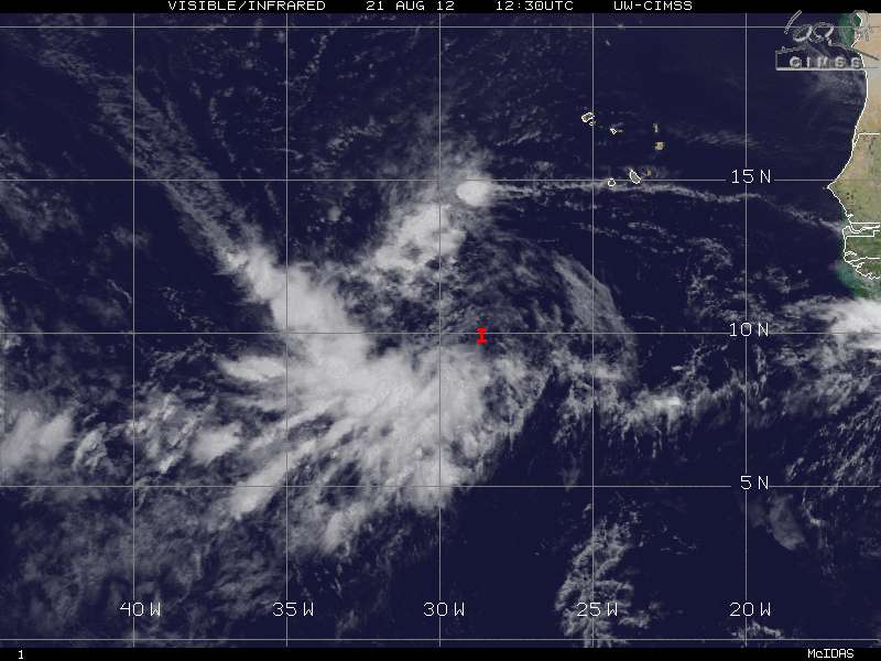
AN ATLANTIC OCEAN TROPICAL WAVE IS ALONG 28W/29W FROM THE
1010 MB LOW PRESSURE CENTER THAT IS NEAR 10N ALONG THE WAVE TO
17N. NUMEROUS STRONG CONVECTIVE PRECIPITATION IS FROM 8N TO 12N
BETWEEN 31W AND 34W. BROKEN TO OVERCAST MULTILAYERED CLOUDS AND
OTHER POSSIBLE RAINSHOWERS ARE ELSEWHERE FROM 8N TO 18N BETWEEN
23W AND 36W. A MIDDLE LEVEL TO UPPER LEVEL INVERTED TROUGH IS
ALONG 23N31W 17N34W 10N35W TO THE WEST OF THIS WAVE. THIS SYSTEM
HAS A HIGH CHANCE OF BECOMING A TROPICAL CYCLONE DURING THE
NEXT 48 HOURS AS IT MOVES WESTWARD 15 TO 20 MPH.
ATL: JOYCE - Post-Tropical
Moderator: S2k Moderators
-
meriland23

- Category 5

- Posts: 1239
- Age: 36
- Joined: Mon Aug 29, 2011 9:29 pm
Re: ATL: INVEST 96L (60%)
what are the chances that this and 94 are both hurricanes you think?
0 likes
The posts in this forum are NOT official forecast and should not be used as such. They are just the opinion of the poster and may or may not be backed by sound meteorological data. They are NOT endorsed by any professional institution or storm2k.org. For official information, please refer to the NHC and NWS products.
-
tolakram
- Admin

- Posts: 19165
- Age: 60
- Joined: Sun Aug 27, 2006 8:23 pm
- Location: Florence, KY (name is Mark)
Re: ATL: INVEST 96L
0 likes
M a r k
- - - - -
Join us in chat: Storm2K Chatroom Invite. Android and IOS apps also available.
The posts in this forum are NOT official forecasts and should not be used as such. Posts are NOT endorsed by any professional institution or STORM2K.org. For official information and forecasts, please refer to NHC and NWS products.
-
Aric Dunn
- Category 5
- Posts: 21228
- Age: 41
- Joined: Sun Sep 19, 2004 9:58 pm
- Location: Ready for the Chase.
- Contact:
we should have td 10 later today. or tonight. convection on the increase this morning and low shear and a closed circ. so if the trend continues as nothing appears to be inhibiting it atm.
0 likes
Note: If I make a post that is brief. Please refer back to previous posts for the analysis or reasoning. I do not re-write/qoute what my initial post said each time.
If there is nothing before... then just ask
Space & Atmospheric Physicist, Embry-Riddle Aeronautical University,
I believe the sky is falling...
If there is nothing before... then just ask
Space & Atmospheric Physicist, Embry-Riddle Aeronautical University,
I believe the sky is falling...

Re:
Aric Dunn wrote:we should have td 10 later today. or tonight. convection on the increase this morning and low shear and a closed circ. so if the trend continues as nothing appears to be inhibiting it atm.
I agree....I wonder why the globals dont do much with it.....
0 likes
-
Weatherfreak000
Re: ATL: INVEST 96L (60%)
meriland23 wrote:what are the chances that this and 94 are both hurricanes you think?
I am not sure... rock brought up the point I was going to but models are sketchy with intensity I mean...I think this invest is a serious player.
0 likes
Re: ATL: INVEST 96L (60%)
Weatherfreak000 wrote:meriland23 wrote:what are the chances that this and 94 are both hurricanes you think?
I am not sure... rock brought up the point I was going to but models are sketchy with intensity I mean...I think this invest is a serious player.
hard to go against presentation right now and 94L managed to chop a hole into the SAL.....low lat, a decent speed, could become a carib cruiser if it holds off developing for a few more days. JMO
0 likes
Re: ATL: INVEST 96L
0 likes
-
Weatherfreak000
-
CrazyC83
- Professional-Met

- Posts: 33393
- Joined: Tue Mar 07, 2006 11:57 pm
- Location: Deep South, for the first time!
Re:
Weatherfreak000 wrote:My shot in the dark guess is yes it should be a Caribbean cruiser.
Being out of 09L's wake would make the water even warmer. I have a REALLY bad feeling about this one...even more so than 09L...
0 likes
-
CrazyC83
- Professional-Met
- Posts: 33393
- Joined: Tue Mar 07, 2006 11:57 pm
- Location: Deep South, for the first time!
http://manati.star.nesdis.noaa.gov/asca ... Bds112.png
1131Z ASCAT pass: Not quite a closed circulation but close; winds likely at tropical storm force (several 30-35 kt barbs). Could be TS Joyce by tonight (assuming 09L becomes Isaac) at this rate.
1131Z ASCAT pass: Not quite a closed circulation but close; winds likely at tropical storm force (several 30-35 kt barbs). Could be TS Joyce by tonight (assuming 09L becomes Isaac) at this rate.
0 likes
-
cycloneye

- Admin
- Posts: 139080
- Age: 67
- Joined: Thu Oct 10, 2002 10:54 am
- Location: San Juan, Puerto Rico
Re: ATL: INVEST 96L
Remains at 60%.
A LOW PRESSURE SYSTEM ASSOCIATED WITH A TROPICAL WAVE...LOCATED
ABOUT 550 MILES SOUTHWEST OF THE CAPE VERDE ISLANDS. ALTHOUGH
SHOWER ACTIVITY IS CURRENTLY NOT WELL ORGANIZED...ENVIRONMENTAL
CONDITIONS APPEAR CONDUCIVE FOR DEVELOPMENT...AND A TROPICAL
DEPRESSION COULD FORM DURING THE NEXT DAY OR TWO. THIS SYSTEM HAS A
HIGH CHANCE...60 PERCENT...OF BECOMING A TROPICAL CYCLONE DURING
THE NEXT 48 HOURS AS IT MOVES WESTWARD AT ABOUT 15 MPH.
0 likes
Visit the Caribbean-Central America Weather Thread where you can find at first post web cams,radars
and observations from Caribbean basin members Click Here
and observations from Caribbean basin members Click Here
-
Gustywind

- Category 5
- Posts: 12334
- Joined: Mon Sep 03, 2007 7:29 am
- Location: Baie-Mahault, GUADELOUPE
000
AXNT20 KNHC 211804
TWDAT
TROPICAL WEATHER DISCUSSION
NWS NATIONAL HURRICANE CENTER MIAMI FL
205 PM EDT TUE AUG 21 2012
TROPICAL WEATHER DISCUSSION FOR NORTH AMERICA...CENTRAL
AMERICA...GULF OF MEXICO...CARIBBEAN SEA...NORTHERN SECTIONS
OF SOUTH AMERICA...AND ATLANTIC OCEAN TO THE AFRICAN COAST
FROM THE EQUATOR TO 32N. THE FOLLOWING INFORMATION IS BASED
ON SATELLITE IMAGERY...WEATHER OBSERVATIONS...RADAR...AND
METEOROLOGICAL ANALYSIS.
BASED ON 1200 UTC SURFACE ANALYSIS AND SATELLITE IMAGERY
THROUGH 1715 UTC.
...SPECIAL FEATURES...
AN ATLANTIC OCEAN TROPICAL WAVE EXTENDS FROM 17N29W TO AN
EMBEDDED 1010 MB LOW AT 10N31W. THE SYSTEM IS MOVING W AT 10-15
KT. THIS SYSTEM HAS A HIGH CHANCE OF BECOMING A TROPICAL CYCLONE
WITHIN THE NEXT 48 HOURS. SCATTERED MODERATE CONVECTION IS OVER
A LARGE AREA FROM 6N-15N BETWEEN 29W-36W.
0 likes
-
cycloneye
- Admin
- Posts: 139080
- Age: 67
- Joined: Thu Oct 10, 2002 10:54 am
- Location: San Juan, Puerto Rico
Re: ATL: INVEST 96L
Let's not forget this little guy,well compared to the other one in front It looks well organized.

0 likes
Visit the Caribbean-Central America Weather Thread where you can find at first post web cams,radars
and observations from Caribbean basin members Click Here
and observations from Caribbean basin members Click Here
-
cycloneye
- Admin
- Posts: 139080
- Age: 67
- Joined: Thu Oct 10, 2002 10:54 am
- Location: San Juan, Puerto Rico
Re: ATL: INVEST 96L
Tropical Cyclone Formation Alert
SUBJ/TROPICAL CYCLONE FORMATION ALERT//
RMKS/1. FORMATION OF A SIGNIFICANT TROPICAL CYCLONE IS POSSIBLE
WITHIN 100 NM EITHER SIDE OF A LINE FROM 09.9N 30.8W TO 11.9N 36.6W
WITHIN THE NEXT 24 HOURS. AVAILABLE DATA DOES NOT JUSTIFY
ISSUANCE OF NUMBERED TROPICAL CYCLONE WARNINGS AT THIS TIME. WINDS
IN THE AREA ARE ESTIMATED TO BE 20 TO 25 KNOTS. METSAT IMAGERY AT
211800Z INDICATES THAT A CIRCULATION CENTER IS LOCATED NEAR 09.9N
30.6W. THE SYSTEM IS MOVING WESTWARD AT 15 KNOTS.
2. REMARKS: A WELL DEFINED LOW PRESSURE SYSTEM ASSOCIATED WITH A
TROPICAL WAVE IS LOCATED ABOUT 550 MILES WEST-SOUTHWEST OF THE
CAPE VERDE ISLANDS. SHOWERS AND THUNDERSTORMS CONTINUE TO SHOW
SIGNS OF ORGANIZATION. THIS TROPICAL WAVE IS TRACKING WEST ALONG THE
SOUTHERN PERIPHERY OF THE SUB-TROPICAL HIGH. LOW WINDS SHEAR VALUES OF
10 TO 15 KNOTS AND SEA SURFACE TEMPERATURES OF 80F TO 84F PROVIDE
AN ENVIRONMENT THAT IS CONDUCIVE FOR TROPICAL DEVELOPMENT DURING
THE NEXT 24 HOURS.
3. THIS ALERT WILL BE UPGRADED TO WARNING OR REISSUED AS REQUIRED
BY 222000Z.//
0 likes
Visit the Caribbean-Central America Weather Thread where you can find at first post web cams,radars
and observations from Caribbean basin members Click Here
and observations from Caribbean basin members Click Here
Who is online
Users browsing this forum: No registered users and 103 guests