ATL: JOYCE - Post-Tropical

Moderator: S2k Moderators

Message
Author
User avatar
Gustywind
Category 5
Category 5
Posts: 12334
Joined: Mon Sep 03, 2007 7:29 am
Location: Baie-Mahault, GUADELOUPE

Re: ATL: INVEST 96L

#61 Postby Gustywind » Tue Aug 21, 2012 5:51 pm

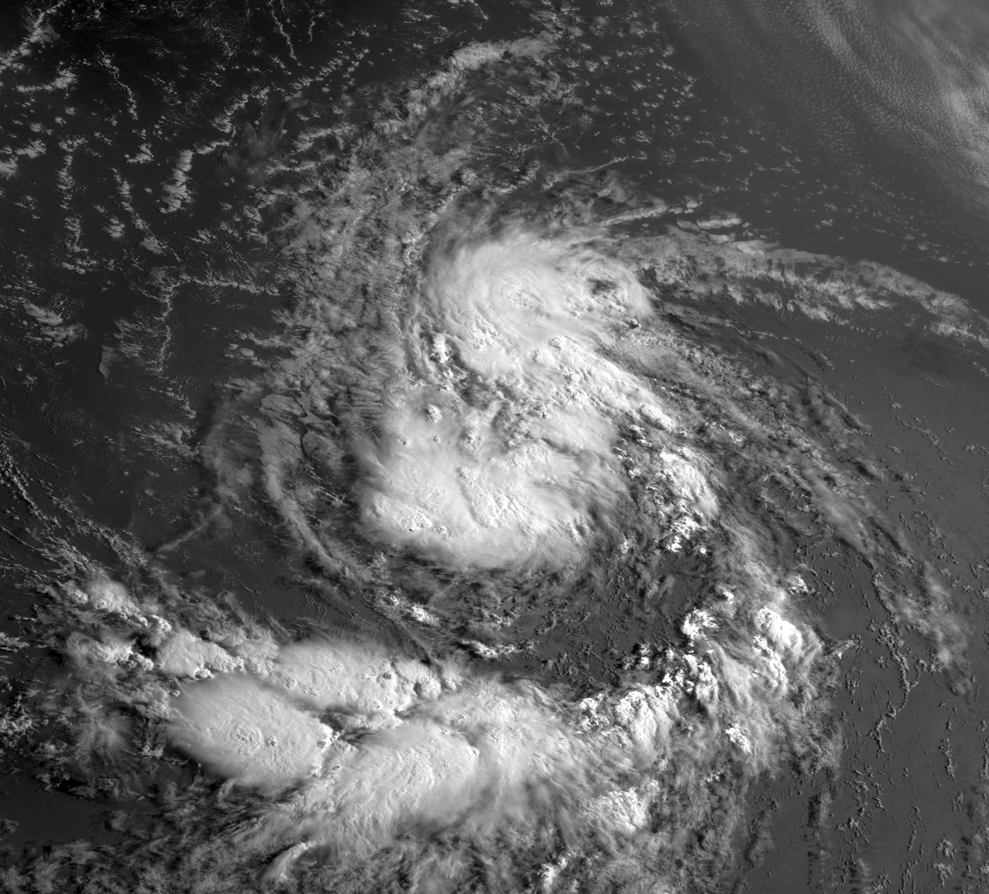
cycloneye wrote:Let's not forget this little guy,well compared to the other one in front :) It looks well organized.

http://www.ssd.noaa.gov/PS/TROP/floater ... imated.gif

You're definitely right :) , and this little guy is fairly south near the 10N and already 30 W. These type of position are always suspicious for any islanders. So let's keep an eye on it.
0 likes   

hurricanes1234
Category 5
Category 5
Posts: 2903
Joined: Sat Jul 28, 2012 6:19 pm
Location: Trinidad and Tobago

Re: ATL: INVEST 96L

#62 Postby hurricanes1234 » Tue Aug 21, 2012 6:06 pm

The posts in this forum are NOT official forecast and should not be used as such. They are just the opinion of the poster and may or may not be backed by sound meteorological data. They are NOT endorsed by any professional institution or storm2k.org. For official information, please refer to the NHC and NWS products.

This low is acquiring a more well-defined shape. I'd go with 70% by the 8 PM update, or even 80%. But I have a gut feeling they'll leave it at 60%. :ggreen:
0 likes   
PLEASE NOTE: With the exception of information from weather agencies that I may copy and paste here, my posts will NEVER be official, since I am NOT a meteorologist. They are solely my amateur opinion, and may or may not be accurate. Therefore, please DO NOT use them as official details, particularly when making important decisions. Thank you.

User avatar
cycloneye
Admin
Admin
Posts: 139008
Age: 67
Joined: Thu Oct 10, 2002 10:54 am
Location: San Juan, Puerto Rico

Re: ATL: INVEST 96L- Up to 70%

#63 Postby cycloneye » Tue Aug 21, 2012 6:57 pm

Up to 70%

A LOW PRESSURE SYSTEM LOCATED ABOUT 600 MILES WEST-SOUTHWEST OF THE
CAPE VERDE ISLANDS CONTINUES TO PRODUCE DISORGANIZED SHOWER AND
THUNDERSTORM ACTIVITY. HOWEVER...ENVIRONMENTAL CONDITIONS APPEAR
CONDUCIVE FOR A TROPICAL DEPRESSION TO FORM DURING THE NEXT DAY OR
SO AS THE LOW MOVES WEST-NORTHWESTWARD AT ABOUT 15 MPH. THIS
SYSTEM HAS A HIGH CHANCE...70 PERCENT...OF BECOMING A TROPICAL
CYCLONE DURING THE NEXT 48 HOURS.
0 likes   
Visit the Caribbean-Central America Weather Thread where you can find at first post web cams,radars
and observations from Caribbean basin members Click Here

chrisjslucia
S2K Supporter
S2K Supporter
Posts: 236
Joined: Thu Oct 09, 2008 8:27 pm
Location: St Lucia

Re: ATL: INVEST 96L

#64 Postby chrisjslucia » Tue Aug 21, 2012 6:57 pm

hurricanes1234 wrote:The posts in this forum are NOT official forecast and should not be used as such. They are just the opinion of the poster and may or may not be backed by sound meteorological data. They are NOT endorsed by any professional institution or storm2k.org. For official information, please refer to the NHC and NWS products.

This low is acquiring a more well-defined shape. I'd go with 70% by the 8 PM update, or even 80%. But I have a gut feeling they'll leave it at 60%. :ggreen:


Did you bet on the lottery today?!! You were on the money for the 70% at 8 pm. Given the way Isaac has hoovered up the SAL, I think this system is going to be a real challenge as it moves west.
0 likes   

User avatar
Gustywind
Category 5
Category 5
Posts: 12334
Joined: Mon Sep 03, 2007 7:29 am
Location: Baie-Mahault, GUADELOUPE

#65 Postby Gustywind » Tue Aug 21, 2012 7:14 pm

000
AXNT20 KNHC 212359
TWDAT

TROPICAL WEATHER DISCUSSION
NWS NATIONAL HURRICANE CENTER MIAMI FL
805 PM EDT TUE AUG 21 2012

TROPICAL WEATHER DISCUSSION FOR NORTH AMERICA...CENTRAL
AMERICA...GULF OF MEXICO...CARIBBEAN SEA...NORTHERN SECTIONS
OF SOUTH AMERICA...AND ATLANTIC OCEAN TO THE AFRICAN COAST
FROM THE EQUATOR TO 32N. THE FOLLOWING INFORMATION IS BASED
ON SATELLITE IMAGERY...WEATHER OBSERVATIONS...RADAR...AND
METEOROLOGICAL ANALYSIS.

BASED ON 1800 UTC SURFACE ANALYSIS AND SATELLITE IMAGERY THROUGH
2315 UTC.

...SPECIAL FEATURES...

AN ATLANTIC OCEAN TROPICAL WAVE EXTENDS FROM 18N30W TO AN
EMBEDDED 1010 MB LOW AT 10N32W. THE SYSTEM IS MOVING W AT 1O TO
15 KT AND HAS A HIGH CHANCE OF BECOMING A TROPICAL CYCLONE
WITHIN THE NEXT 48 HOURS.
SCATTERED MODERATE CONVECTION IS OVER
A LARGE AREA FROM 07N TO 14N BETWEEN 32W AND 38W.
0 likes   

User avatar
Gustywind
Category 5
Category 5
Posts: 12334
Joined: Mon Sep 03, 2007 7:29 am
Location: Baie-Mahault, GUADELOUPE

#66 Postby Gustywind » Tue Aug 21, 2012 7:25 pm

Hey, what's up with SSD? Look at that? :?: How can we understand and thus, explain that? 96L has gained TD status or not? Surely a mistake or not? Name of what??? Is that another twave? Looks like a big west bound if its verifies (in case of it's 96L)?! Anyone noticied that???? More than curious! If someone have an solid explanation :) i will be glad. :D

:rarrow: http://www.ssd.noaa.gov/PS/TROP/tdpositions.html


21/2345 UTC 10.7N 34.0W TOO WEAK NAME
21/2330 UTC 10.6N 33.9W TOO WEAK NAME
0 likes   

hurricanes1234
Category 5
Category 5
Posts: 2903
Joined: Sat Jul 28, 2012 6:19 pm
Location: Trinidad and Tobago

Re: ATL: INVEST 96L

#67 Postby hurricanes1234 » Tue Aug 21, 2012 7:29 pm

chrisjslucia wrote:
hurricanes1234 wrote:The posts in this forum are NOT official forecast and should not be used as such. They are just the opinion of the poster and may or may not be backed by sound meteorological data. They are NOT endorsed by any professional institution or storm2k.org. For official information, please refer to the NHC and NWS products.

This low is acquiring a more well-defined shape. I'd go with 70% by the 8 PM update, or even 80%. But I have a gut feeling they'll leave it at 60%. :ggreen:


Did you bet on the lottery today?!! You were on the money for the 70% at 8 pm. Given the way Isaac has hoovered up the SAL, I think this system is going to be a real challenge as it moves west.


:ggreen: :D
0 likes   
PLEASE NOTE: With the exception of information from weather agencies that I may copy and paste here, my posts will NEVER be official, since I am NOT a meteorologist. They are solely my amateur opinion, and may or may not be accurate. Therefore, please DO NOT use them as official details, particularly when making important decisions. Thank you.

rainstorm

Re: ATL: INVEST 96L

#68 Postby rainstorm » Tue Aug 21, 2012 8:30 pm

one thing of concern. models are showing building high pressure in the NW atlantic. 96L, if it develops, may get alot further west than indicated so far.
0 likes   

HurricaneFan
Tropical Storm
Tropical Storm
Posts: 192
Age: 40
Joined: Tue Jan 18, 2011 6:16 pm
Location: Anguilla,Leeward Islands 18.3N 63.0W

Re: ATL: INVEST 96L

#69 Postby HurricaneFan » Tue Aug 21, 2012 8:35 pm

rainstorm wrote:one thing of concern. models are showing building high pressure in the NW atlantic. 96L, if it develops, may get alot further west than indicated so far.


Do you think this one can reach the Lesser Antilles too?
0 likes   

User avatar
ROCK
Category 5
Category 5
Posts: 9254
Age: 52
Joined: Tue Aug 17, 2004 7:30 am
Location: Kemah, Texas

Re: ATL: INVEST 96L

#70 Postby ROCK » Tue Aug 21, 2012 8:40 pm

HurricaneFan wrote:
rainstorm wrote:one thing of concern. models are showing building high pressure in the NW atlantic. 96L, if it develops, may get alot further west than indicated so far.


Do you think this one can reach the Lesser Antilles too?


I do....GFS notorious for underestimating the ridging and this is like at 10N.....really depends on how fast it can develope, IMO....
0 likes   

rainstorm

Re: ATL: INVEST 96L

#71 Postby rainstorm » Tue Aug 21, 2012 9:19 pm

HurricaneFan wrote:
rainstorm wrote:one thing of concern. models are showing building high pressure in the NW atlantic. 96L, if it develops, may get alot further west than indicated so far.


Do you think this one can reach the Lesser Antilles too?


i have to disagree with rock. i think it most likely will go north of them, but we will see. it has to develop first.
0 likes   

User avatar
Riptide
Category 2
Category 2
Posts: 753
Age: 32
Joined: Fri Jul 23, 2010 3:33 pm
Location: Cape May, New Jersey
Contact:

Re: ATL: INVEST 96L

#72 Postby Riptide » Tue Aug 21, 2012 9:30 pm

rainstorm wrote:
HurricaneFan wrote:
rainstorm wrote:one thing of concern. models are showing building high pressure in the NW atlantic. 96L, if it develops, may get alot further west than indicated so far.


Do you think this one can reach the Lesser Antilles too?


i have to disagree with rock. i think it most likely will go north of them, but we will see. it has to develop first.

I honestly believe this is a non-threat for the United States unless Isaac gets out of the way more quickly, otherwise it's just going to drift out in the Atlantic and get picked up eventually because Isaac will create a huge weakness in the Western Atlantic.
0 likes   

User avatar
cycloneye
Admin
Admin
Posts: 139008
Age: 67
Joined: Thu Oct 10, 2002 10:54 am
Location: San Juan, Puerto Rico

Re: ATL: INVEST 96L

#73 Postby cycloneye » Wed Aug 22, 2012 1:03 am

Up to 90%

SHOWERS AND THUNDERSTORMS HAVE BECOME BETTER ORGANIZED IN
ASSOCIATION WITH A LOW PRESSURE SYSTEM LOCATED ABOUT 650 MILES
WEST-SOUTHWEST OF THE CAPE VERDE ISLANDS. ENVIRONMENTAL CONDITIONS
APPEAR CONDUCIVE FOR A TROPICAL DEPRESSION TO FORM LATER TODAY AS
THE LOW MOVES WEST-NORTHWESTWARD AT ABOUT 15 MPH. THIS SYSTEM HAS
A HIGH CHANCE...90 PERCENT...OF BECOMING A TROPICAL CYCLONE DURING
THE NEXT 48 HOURS.
0 likes   
Visit the Caribbean-Central America Weather Thread where you can find at first post web cams,radars
and observations from Caribbean basin members Click Here

bob rulz
Category 5
Category 5
Posts: 1667
Age: 34
Joined: Sat Jan 28, 2006 7:30 pm
Location: Salt Lake City, Utah

Re: ATL: INVEST 96L

#74 Postby bob rulz » Wed Aug 22, 2012 3:15 am

Wow, they're really optimistic about this one. Let's not make the mistake of overlooking this little guy!
0 likes   

User avatar
northjaxpro
S2K Supporter
S2K Supporter
Posts: 8900
Joined: Mon Sep 27, 2010 11:21 am
Location: Jacksonville, FL

#75 Postby northjaxpro » Wed Aug 22, 2012 4:34 am

Looking at satellite imagery early this morning, this system is looking very impressive. The expansive moisture envelope and circulation is just as impressive as what we are currently seeing with Isaac. I think that this may already be a TS.

GFS runs for the past few days showed this system moving west towards the Eastern Caribbean by the end of this weekend into early next week. This is definitely one to watch.
_____________________

The posts in this forum are NOT official forecast. They are just the opinion of this poster For official information, please refer to the NHC and NWS products
0 likes   
NEVER, EVER SAY NEVER in the tropics and weather in general, and most importantly, with life itself!!

________________________________________________________________________________________

Fay 2008 Beryl 2012 Debby 2012 Colin 2016 Hermine 2016 Julia 2016 Matthew 2016 Irma 2017 Dorian 2019

User avatar
TheBurn
Category 2
Category 2
Posts: 524
Joined: Thu Jul 28, 2005 4:00 pm
Location: Rincon, PR

Re: ATL: INVEST 96L

#76 Postby TheBurn » Wed Aug 22, 2012 5:37 am

10:00 UTC RGB / Natural Color

Image
0 likes   

User avatar
Gustywind
Category 5
Category 5
Posts: 12334
Joined: Mon Sep 03, 2007 7:29 am
Location: Baie-Mahault, GUADELOUPE

#77 Postby Gustywind » Wed Aug 22, 2012 5:44 am

22/0545 UTC 11.8N 34.4W T1.5/1.5 NAME
0 likes   

tolakram
Admin
Admin
Posts: 19165
Age: 60
Joined: Sun Aug 27, 2006 8:23 pm
Location: Florence, KY (name is Mark)

Re: ATL: INVEST 96L

#78 Postby tolakram » Wed Aug 22, 2012 6:34 am

Morning HiRes visible

Image
0 likes   
M a r k
- - - - -
Join us in chat: Storm2K Chatroom Invite. Android and IOS apps also available.

The posts in this forum are NOT official forecasts and should not be used as such. Posts are NOT endorsed by any professional institution or STORM2K.org. For official information and forecasts, please refer to NHC and NWS products.

User avatar
cycloneye
Admin
Admin
Posts: 139008
Age: 67
Joined: Thu Oct 10, 2002 10:54 am
Location: San Juan, Puerto Rico

Re: ATL: INVEST 96L- Up to near 100%

#79 Postby cycloneye » Wed Aug 22, 2012 7:12 am

Up to near 100%

SATELLITE IMAGERY INDICATES THAT A TROPICAL DEPRESSION COULD BE
FORMING IN THE EASTERN TROPICAL ATLANTIC ABOUT 725 MILES
WEST-SOUTHWEST OF THE CAPE VERDE ISLANDS. IF CURRENT TRENDS
CONTINUE...ADVISORIES WOULD BE INITIATED LATER THIS MORNING. THIS
SYSTEM HAS A HIGH CHANCE...NEAR 100 PERCENT...OF BECOMING A
TROPICAL CYCLONE DURING THE NEXT 48 HOURS.
0 likes   
Visit the Caribbean-Central America Weather Thread where you can find at first post web cams,radars
and observations from Caribbean basin members Click Here

User avatar
Gustywind
Category 5
Category 5
Posts: 12334
Joined: Mon Sep 03, 2007 7:29 am
Location: Baie-Mahault, GUADELOUPE

#80 Postby Gustywind » Wed Aug 22, 2012 7:19 am

000
AXNT20 KNHC 221155
TWDAT

TROPICAL WEATHER DISCUSSION
NWS NATIONAL HURRICANE CENTER MIAMI FL
805 AM EDT WED AUG 22 2012

TROPICAL WEATHER DISCUSSION FOR NORTH AMERICA...CENTRAL
AMERICA...GULF OF MEXICO...CARIBBEAN SEA...NORTHERN SECTIONS
OF SOUTH AMERICA...AND ATLANTIC OCEAN TO THE AFRICAN COAST
FROM THE EQUATOR TO 32N. THE FOLLOWING INFORMATION IS BASED
ON SATELLITE IMAGERY...WEATHER OBSERVATIONS...RADAR...AND
METEOROLOGICAL ANALYSIS.

BASED ON 0600 UTC SURFACE ANALYSIS AND SATELLITE IMAGERY
THROUGH 1115 UTC.

...SPECIAL FEATURES...


AN ATLANTIC OCEAN TROPICAL WAVE IS ALONG 34W/35W FROM THE
1010 MB LOW PRESSURE CENTER THAT IS NEAR 11N ALONG THE WAVE
TO 17N...MOVING WESTWARD 15 KNOTS.
CONVECTIVE PRECIPITATION...
SCATTERED TO NUMEROUS STRONG FROM 12N TO 16N BETWEEN 33W AND
37W AND FROM 7N TO 9N BETWEEN 37W AND 41W. BROKEN TO OVERCAST
MULTILAYERED CLOUDS AND OTHER POSSIBLE RAINSHOWERS ARE
ELSEWHERE FROM 3N TO 22N BETWEEN 30W AND 42W. A MIDDLE LEVEL
TO UPPER LEVEL INVERTED TROUGH IS ABOUT 240 NM TO THE WEST OF
THIS WAVE TO THE SOUTH OF 23N. THIS SYSTEM HAS A HIGH CHANCE
OF BECOMING A TROPICAL DEPRESSION LATER TODAY
AS THE 1010 MB LOW
PRESSURE CENTER MOVES WEST-NORTHWESTWARD 13 KNOTS.
0 likes   


Return to “2012”

Who is online

Users browsing this forum: No registered users and 19 guests