ATL: NADINE - Post-Tropical - Discussion

Moderator: S2k Moderators

Message
Author
User avatar
greenkat
Tropical Storm
Tropical Storm
Posts: 161
Joined: Wed Aug 01, 2012 12:19 pm
Location: Seattle, WA, USA

Re: ATL: INVEST 91L - Discussion

#21 Postby greenkat » Sat Sep 08, 2012 5:37 pm

HurricaneAndrew92 wrote:
greenkat wrote:
HurricaneAndrew92 wrote:Watch for this to recurve at 60W. Intensity is just non-educated guessing.

http://img211.imageshack.us/img211/3961/i91.png


How do you make those? I would like to take a try myself :)

Hold on, give me a sec I'll edit this out in 5 minutes.

EDIT:Hey greencat, you need MS paint, and heres the link for pictures, just right click on them and Save As...
viewtopic.php?f=59&t=113481


Thanks alot! :jump:
0 likes   
Personal Forecast Disclaimer:
The posts in this forum are NOT official forecast and should not be used as such. They are just the opinion of the poster and may or may not be backed by sound meteorological data. They are NOT endorsed by any professional institution or storm2k.org.

Hope this helped ;)

User avatar
greenkat
Tropical Storm
Tropical Storm
Posts: 161
Joined: Wed Aug 01, 2012 12:19 pm
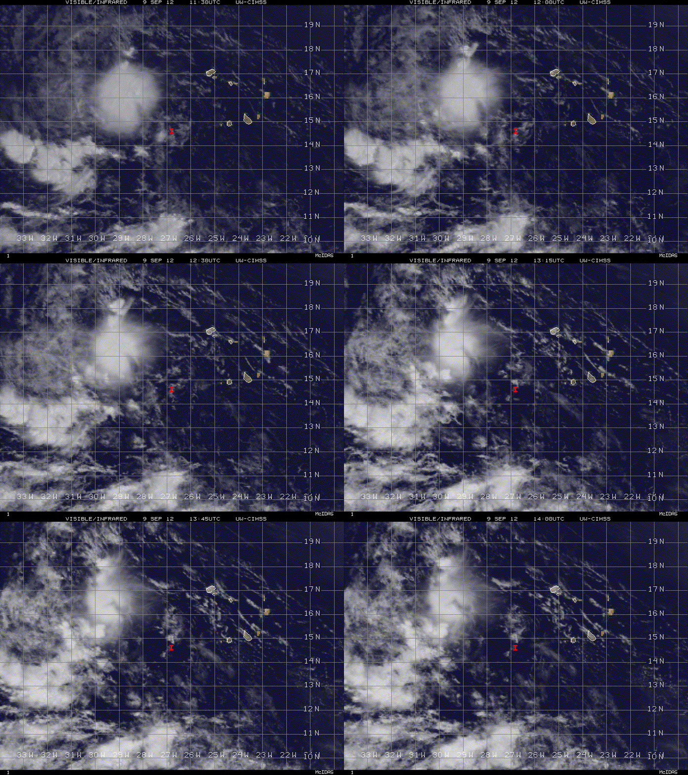
Location: Seattle, WA, USA

Re: ATL: INVEST 91L - Discussion

#22 Postby greenkat » Sat Sep 08, 2012 5:55 pm

Image

My opinion :uarrow:

This post is NOT AN OFFICIAL FORECAST and should not be used as such. It is just the opinion of the poster and may or may not be backed by sound meteorological data. It is NOT endorsed by any professional institution including storm2k.org. For Official Information please refer to the NHC and NWS products.
0 likes   
Personal Forecast Disclaimer:
The posts in this forum are NOT official forecast and should not be used as such. They are just the opinion of the poster and may or may not be backed by sound meteorological data. They are NOT endorsed by any professional institution or storm2k.org.

Hope this helped ;)

User avatar
cycloneye
Admin
Admin
Posts: 139009
Age: 67
Joined: Thu Oct 10, 2002 10:54 am
Location: San Juan, Puerto Rico

Re: ATL: INVEST 91L - Discussion

#23 Postby cycloneye » Sat Sep 08, 2012 6:39 pm

It remains at 40% on 8 PM TWO.

SHOWERS AND THUNDERSTORMS HAVE CHANGED LITTLE IN ORGANIZATION NEAR A
TROPICAL WAVE THAT IS MOVING WESTWARD ACROSS THE CAPE VERDE
ISLANDS. ENVIRONMENTAL CONDITIONS APPEAR FAVORABLE FOR GRADUAL
DEVELOPMENT...AND THIS SYSTEM HAS A MEDIUM CHANCE...40 PERCENT...OF
BECOMING A TROPICAL CYCLONE DURING THE NEXT 48 HOURS AS IT MOVES
WESTWARD AT ABOUT 20 MPH.
0 likes   
Visit the Caribbean-Central America Weather Thread where you can find at first post web cams,radars
and observations from Caribbean basin members Click Here

User avatar
cycloneye
Admin
Admin
Posts: 139009
Age: 67
Joined: Thu Oct 10, 2002 10:54 am
Location: San Juan, Puerto Rico

Re: ATL: INVEST 91L - Discussion

#24 Postby cycloneye » Sat Sep 08, 2012 7:53 pm

Which is it? No consensus between 00z Best Track and SSD Dvorak. :)

AL, 91, 2012090900, , BEST, 0, 145N, 249W, 25, 1008, LO

09/0000 UTC 16.0N 25.2W T1.0/1.0 91L -- Atlantic
0 likes   
Visit the Caribbean-Central America Weather Thread where you can find at first post web cams,radars
and observations from Caribbean basin members Click Here

sharoncapecod
Tropical Wave
Tropical Wave
Posts: 5
Joined: Sat Sep 08, 2012 3:48 pm

Re: ATL: INVEST 91L - Discussion

#25 Postby sharoncapecod » Sat Sep 08, 2012 8:42 pm

Hello everyone! I'm new here but have been reading your posts for a while. Learning alot from them. I have been extremely fascinated by weather for a long time and even more since moving to Cape Cod! Hope to be able to join your discussions soon with my own knowledge!
0 likes   

katenjay
Tropical Wave
Tropical Wave
Posts: 2
Joined: Sat Sep 08, 2012 3:53 pm

Re: ATL: INVEST 91L - Discussion

#26 Postby katenjay » Sat Sep 08, 2012 8:50 pm

Hi everyone! I have read that several of you think this system might recurve, which is what I am hoping for as well. How long do you think we might potentially be dealing with this system? I am going to Jamaica on the 20th and I am hoping this will not affect my travel plans. Keeping fingers crossed!
0 likes   

User avatar
cycloneye
Admin
Admin
Posts: 139009
Age: 67
Joined: Thu Oct 10, 2002 10:54 am
Location: San Juan, Puerto Rico

Re: ATL: INVEST 91L - Discussion

#27 Postby cycloneye » Sat Sep 08, 2012 8:50 pm

sharoncapecod wrote:Hello everyone! I'm new here but have been reading your posts for a while. Learning alot from them. I have been extremely fascinated by weather for a long time and even more since moving to Cape Cod! Hope to be able to join your discussions soon with my own knowledge!


Welcome to Storm2k and enjoy all the forums that we have. If you have any question(s),dont hesitate to ask.
0 likes   
Visit the Caribbean-Central America Weather Thread where you can find at first post web cams,radars
and observations from Caribbean basin members Click Here

DukeDevil91
S2K Supporter
S2K Supporter
Posts: 62
Joined: Thu Sep 08, 2011 4:04 pm

Re: ATL: INVEST 91L - Discussion

#28 Postby DukeDevil91 » Sun Sep 09, 2012 5:58 am

This, IMO, is the most logical path.

Image

Uploaded with ImageShack.us
0 likes   

User avatar
cycloneye
Admin
Admin
Posts: 139009
Age: 67
Joined: Thu Oct 10, 2002 10:54 am
Location: San Juan, Puerto Rico

Re: ATL: INVEST 91L - Discussion

#29 Postby cycloneye » Sun Sep 09, 2012 6:26 am

This is the 8 AM Discussion that came out before the TWO.

A TROPICAL WAVE AND ASSOCIATED 1008 MB LOW IS ANALYZED A COUPLE
OF HUNDRED MILES WEST OF THE CAPE VERDE ISLANDS FROM 20N25W TO
THE LOW LEVEL CENTER NEAR 15N27W...MOVING W AT 10-15 KT. THIS
SYSTEM COINCIDES WITH A SURGE OF DEEP LAYER MOISTURE NOTED ON
TOTAL PRECIPITABLE WATER IMAGERY...AROUND THE OCEANIC MONSOONAL
GYRE DESCRIBED BELOW. SCATTERED MODERATE CONVECTION IS FROM
13N-17N BETWEEN 26W-31W. ENVIRONMENTAL CONDITIONS APPEAR
FAVORABLE FOR GRADUAL DEVELOPMENT OF THE WAVE. THIS SYSTEM HAS A
MEDIUM CHANCE OF BECOMING A TROPICAL CYCLONE DURING THE NEXT 48
HOURS.

8 AM TWO:

AN AREA OF LOW PRESSURE ASSOCIATED WITH A TROPICAL WAVE IS LOCATED
ABOUT 200 MILES WEST OF THE CAPE VERDE ISLANDS. ALTHOUGH THIS
DISTURBANCE HAS CHANGED LITTLE IN ORGANIZATION DURING THE LAST
SEVERAL HOURS...ENVIRONMENTAL CONDITIONS ARE MARGINALLY FAVORABLE
FOR SLOW DEVELOPMENT DURING THE NEXT COUPLE OF DAYS. THIS SYSTEM
HAS A MEDIUM CHANCE...40 PERCENT...OF BECOMING A TROPICAL CYCLONE
DURING THE NEXT 48 HOURS AS IT MOVES WEST-NORTHWESTWARD AT 10 TO 15
MPH.
0 likes   
Visit the Caribbean-Central America Weather Thread where you can find at first post web cams,radars
and observations from Caribbean basin members Click Here

User avatar
cycloneye
Admin
Admin
Posts: 139009
Age: 67
Joined: Thu Oct 10, 2002 10:54 am
Location: San Juan, Puerto Rico

Re: ATL: INVEST 91L - Discussion

#30 Postby cycloneye » Sun Sep 09, 2012 8:22 am

SSD Dvorak T numbers go up.

09/1200 UTC 15.0N 27.7W T1.5/1.5 91L -- Atlantic

http://www.ssd.noaa.gov/PS/TROP/tdpositions.html
0 likes   
Visit the Caribbean-Central America Weather Thread where you can find at first post web cams,radars
and observations from Caribbean basin members Click Here

tolakram
Admin
Admin
Posts: 19165
Age: 60
Joined: Sun Aug 27, 2006 8:23 pm
Location: Florence, KY (name is Mark)

Re: ATL: INVEST 91L - Discussion

#31 Postby tolakram » Sun Sep 09, 2012 9:41 am

Latest Loop

Image
0 likes   
M a r k
- - - - -
Join us in chat: Storm2K Chatroom Invite. Android and IOS apps also available.

The posts in this forum are NOT official forecasts and should not be used as such. Posts are NOT endorsed by any professional institution or STORM2K.org. For official information and forecasts, please refer to NHC and NWS products.

hurricanes1234
Category 5
Category 5
Posts: 2903
Joined: Sat Jul 28, 2012 6:19 pm
Location: Trinidad and Tobago

Re: ATL: INVEST 91L - Discussion

#32 Postby hurricanes1234 » Sun Sep 09, 2012 10:20 am

Convection literally blew away. :roll:
0 likes   
PLEASE NOTE: With the exception of information from weather agencies that I may copy and paste here, my posts will NEVER be official, since I am NOT a meteorologist. They are solely my amateur opinion, and may or may not be accurate. Therefore, please DO NOT use them as official details, particularly when making important decisions. Thank you.

floridasun78
Category 5
Category 5
Posts: 3755
Joined: Sun May 17, 2009 10:16 pm
Location: miami fl

Re: ATL: INVEST 91L - Discussion

#33 Postby floridasun78 » Sun Sep 09, 2012 10:32 am

it look like dry air hitting it
0 likes   

User avatar
cycloneye
Admin
Admin
Posts: 139009
Age: 67
Joined: Thu Oct 10, 2002 10:54 am
Location: San Juan, Puerto Rico

Re: ATL: INVEST 91L - Discussion

#34 Postby cycloneye » Sun Sep 09, 2012 10:38 am

12z Best Track came out very late.

AL, 91, 2012090912, , BEST, 0, 149N, 278W, 25, 1008, LO

ftp://ftp.nhc.noaa.gov/atcf/tcweb/inves ... 012.invest
0 likes   
Visit the Caribbean-Central America Weather Thread where you can find at first post web cams,radars
and observations from Caribbean basin members Click Here

User avatar
Hurricaneman
Category 5
Category 5
Posts: 7280
Age: 43
Joined: Tue Aug 31, 2004 3:24 pm
Location: central florida

Re: ATL: INVEST 91L - Discussion

#35 Postby Hurricaneman » Sun Sep 09, 2012 10:53 am

It looks like it may be reforming at about 14.5N 32.5W or may be where the best MLC is far removed from the circulation they're following which if true may not allow for recurvature due to being a weaker system


The posts in this forum are NOT official forecast and should not be used as such. They are just the opinion of the poster and may or may not be backed by sound meteorological data. They are NOT endorsed by any professional institution or storm2k.org. For official information, please refer to the NHC and NWS products
0 likes   

floridasun78
Category 5
Category 5
Posts: 3755
Joined: Sun May 17, 2009 10:16 pm
Location: miami fl

#36 Postby floridasun78 » Sun Sep 09, 2012 11:10 am

will this invest ever get to be td?
0 likes   

User avatar
cycloneye
Admin
Admin
Posts: 139009
Age: 67
Joined: Thu Oct 10, 2002 10:54 am
Location: San Juan, Puerto Rico

Re: ATL: INVEST 91L - Discussion

#37 Postby cycloneye » Sun Sep 09, 2012 1:00 pm

2 PM TWO.

SHOWER ACTIVITY ASSOCIATED WITH AN AREA OF LOW PRESSURE LOCATED A
FEW HUNDRED MILES WEST OF THE CAPE VERDE ISLANDS HAS BECOME LESS
ORGANIZED TODAY. ALTHOUGH UPPER-LEVEL WINDS ARE GENERALLY
FAVORABLE...DRY AIR IN THE VICINITY OF THIS DISTURBANCE COULD
HINDER DEVELOPMENT DURING THE NEXT DAY OR SO. THIS SYSTEM HAS A
MEDIUM CHANCE...40 PERCENT...OF BECOMING A TROPICAL CYCLONE DURING
THE NEXT 48 HOURS AS IT MOVES WEST- NORTHWESTWARD AT 10 TO 15 MPH.
0 likes   
Visit the Caribbean-Central America Weather Thread where you can find at first post web cams,radars
and observations from Caribbean basin members Click Here

hurricanes1234
Category 5
Category 5
Posts: 2903
Joined: Sat Jul 28, 2012 6:19 pm
Location: Trinidad and Tobago

Re: ATL: INVEST 91L - Discussion

#38 Postby hurricanes1234 » Sun Sep 09, 2012 1:07 pm

Will this be the next poof of the season? I must admit, though, there haven't been much poofs in the Atlantic this year - more poofs and busts have been occurring in the Pacific.
0 likes   
PLEASE NOTE: With the exception of information from weather agencies that I may copy and paste here, my posts will NEVER be official, since I am NOT a meteorologist. They are solely my amateur opinion, and may or may not be accurate. Therefore, please DO NOT use them as official details, particularly when making important decisions. Thank you.

Florida1118
Category 5
Category 5
Posts: 1805
Age: 27
Joined: Sat Jun 19, 2010 12:57 pm
Location: Tampa, Florida

Re: ATL: INVEST 91L - Discussion

#39 Postby Florida1118 » Sun Sep 09, 2012 1:33 pm

hurricanes1234 wrote:Will this be the next poof of the season? I must admit, though, there haven't been much poofs in the Atlantic this year - more poofs and busts have been occurring in the Pacific.

Nothing has indicated its a poof. Did it lose its convection? Yes, But give it time.
0 likes   

User avatar
brunota2003
S2K Supporter
S2K Supporter
Posts: 9476
Age: 33
Joined: Sat Jul 30, 2005 9:56 pm
Location: Stanton, KY...formerly Havelock, NC
Contact:

Re: ATL: INVEST 91L - Discussion

#40 Postby brunota2003 » Sun Sep 09, 2012 1:43 pm

Welcome to Hurricane Season, Global Hawk!

000
NOUS42 KNHC 091640
REPRPD
WEATHER RECONNAISSANCE FLIGHTS
CARCAH, NATIONAL HURRICANE CENTER, MIAMI, FL.
1145 AM EDT SUN 09 SEPTEMBER 2012
SUBJECT: TROPICAL CYCLONE PLAN OF THE DAY (TCPOD)
VALID 10/1100Z TO 11/1100Z SEPTEMBER 2012
TCPOD NUMBER.....12-113

I. ATLANTIC REQUIREMENTS
1. NEGATIVE RECONNAISSANCE REQUIREMENTS.
2. OUTLOOK FOR SUCCEEDING DAY: POSSIBLE NASA GLOBAL
HAWK MISSION AROUND CENTRAL ATLANTIC SUSPECT AL91.

3. REMARK: 09/1800Z FIX MISSION INTO TROPICAL STORM
LESLIE CANCELED BY NHC AT 09/0900Z.

II. PACIFIC REQUIREMENTS
1. NEGATIVE RECONNAISSANCE REQUIREMENTS.
2. OUTLOOK FOR SUCCEEDING DAY.....NEGATIVE.

$$
SEF
0 likes   
Just a small town southern boy helping other humans.


Return to “2012”

Who is online

Users browsing this forum: No registered users and 19 guests