ATCF resumes Best Track data for 97L.
AL, 97, 2012101018, , BEST, 0, 257N, 723W, 20, 1013, LO
http://ftp.nhc.noaa.gov/atcf/tcweb/inve ... 012.invest
ATL: PATTY - Remnants - Discussion
Moderator: S2k Moderators
-
cycloneye

- Admin

- Posts: 139192
- Age: 67
- Joined: Thu Oct 10, 2002 10:54 am
- Location: San Juan, Puerto Rico
Re: ATL: INVEST 97L - Discussion
0 likes
Visit the Caribbean-Central America Weather Thread where you can find at first post web cams,radars
and observations from Caribbean basin members Click Here
and observations from Caribbean basin members Click Here
-
floridasun78
- Category 5

- Posts: 3755
- Joined: Sun May 17, 2009 10:16 pm
- Location: miami fl
Re: ATL: INVEST 97L - Discussion
000
ABNT20 KNHC 101732
TWOAT
TROPICAL WEATHER OUTLOOK
NWS NATIONAL HURRICANE CENTER MIAMI FL
200 PM EDT WED OCT 10 2012 A WEAK AREA OF LOW PRESSURE LOCATED A COUPLE OF HUNDRED MILES EAST
OF THE CENTRAL BAHAMAS HAS BECOME A LITTLE BETTER DEFINED THIS
AFTERNOON. ENVIRONMENTAL CONDITIONS ARE ONLY MARGIANALLY CONDUCIVE
FOR DEVELOPMENT DURING THE NEXT DAY OR SO BEFORE THE LOW MERGES
WITH A FRONT THURSDAY NIGHT OR FRIDAY. THIS SYSTEM HAS A LOW
CHANCE...10 PERCENT...OF BECOMING A TROPICAL CYCLONE DURING THE
NEXT 48 HOURS AS IT MOVES LITTLE.
0 likes
-
gatorcane

- S2K Supporter

- Posts: 23499
- Age: 46
- Joined: Sun Mar 13, 2005 3:54 pm
- Location: Boca Raton, FL
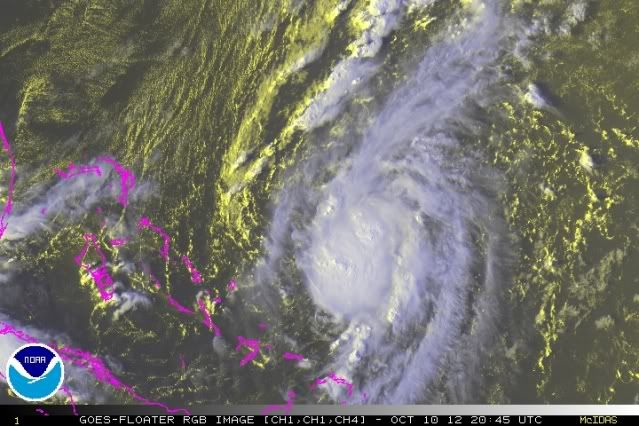
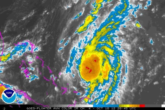
I would say they will raise the % chance of development for the next TWO. Convection building nicely with some nice outflow and it is just east of the high shear zone over the Western Bahamas and Florida. So upper-level conditions look conducive for more organization. Some model support is there calling for a weak system to move generally SW then dissipate because of the high shear. I am not sure what front the NHC expects this system to get absorbed into though. Certainly this system is not an "it's dead Jim" system! 
0 likes
-
ozonepete
- Professional-Met

- Posts: 4743
- Joined: Mon Sep 07, 2009 3:23 pm
- Location: From Ozone Park, NYC / Now in Brooklyn, NY
Re:
gatorcane wrote:I would say they will raise the % chance of development for the next TWO. Convection building nicely with some nice outflow and it is just east of the high shear zone over the Western Bahamas and Florida. So upper-level conditions look conducive for more organization. Some model support is there calling for a weak system to move generally SW then dissipate because of the high shear. I am not sure what front the NHC expects this system to get absorbed into though. Certainly this system is not an "it's dead Jim" system!
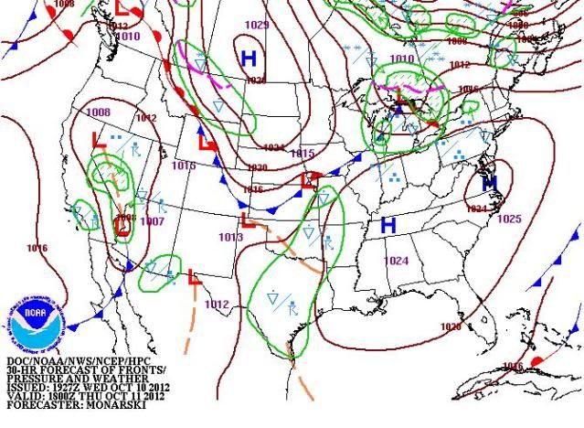
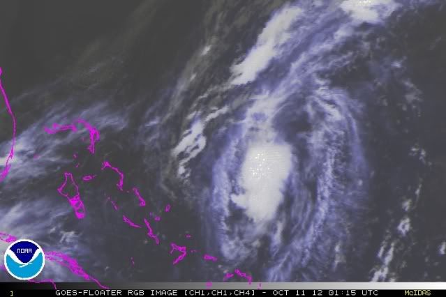
I attached the HPC surface forecast for tomorrow at 18Z. I think the models didn't catch it correctly because the center has formed SE of where the models had it. When they get a better fix I would think they would have it stationary for another 24 hours or so and then the approaching front should take it northeastward, but shear is low to the northeast so it may have a fair amount of time, especially because that front appears to be slowing down some.
Sure looks good right now - even has a small anti-cyclone over it - that's why it has such good outflow. And DMAX is coming later tonight...
0 likes
-
Hurricane_Luis

- Category 2

- Posts: 723
- Age: 26
- Joined: Sat Jun 23, 2012 3:14 pm
- Location: Tiptree, Essex, United Kingdom
- Contact:

-
SouthDadeFish

- Professional-Met
- Posts: 2835
- Joined: Thu Sep 23, 2010 2:54 pm
- Location: Miami, FL
- Contact:

-
gatorcane
- S2K Supporter
- Posts: 23499
- Age: 46
- Joined: Sun Mar 13, 2005 3:54 pm
- Location: Boca Raton, FL
Re:
SouthDadeFish wrote:Ummmm.... Closed low. Should be >10% IMO...If convection persists through the night this could be a TD.
I would say maybe even a special weather statement could be in order tonight if things keep up the way they are going. I have seen TDs classified that look much worse than this.
It will be interesting to see where this ends up and what happens. If it deepens quickly, it should move off to the NE and potentially strengthen further with low shear and high oceanic heat content. It could stall and get absorbed by the front (ECMWF). Or it could stay relatively shallow and head SW towards Cuba and the reemerge into the Western Caribbean (GFS/CMC/BAMS). Models are in good agreement on alot of shear being around in the Western Caribbean by the weekend and into next week so it shouldn't do much if it goes that way (you never know though especially since we are in October and that is an area that is typically favorable for development).
0 likes
-
ozonepete
- Professional-Met
- Posts: 4743
- Joined: Mon Sep 07, 2009 3:23 pm
- Location: From Ozone Park, NYC / Now in Brooklyn, NY
Re: ATL: INVEST 97L - Discussion
I agree with you guys - 10% is way too low. It already looks like a TD. I think they'll bump it to at least 60% at the 8PM outlook. But you could be right, gator, this is developing so rapidly they may have to do a special statement. Although it's not threatening any land right now. (Think it stays north enough of the Bahamas and it's small.)
0 likes
-
ozonepete
- Professional-Met
- Posts: 4743
- Joined: Mon Sep 07, 2009 3:23 pm
- Location: From Ozone Park, NYC / Now in Brooklyn, NY
Re: ATL: INVEST 97L - Discussion
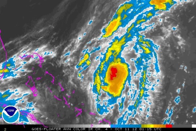
I'm pretty sure the center either drifted southeastward or reformed under the convection since the ASCAT pass at 1415 that southdade just posted a little ways back.
0 likes
-
somethingfunny

- ChatStaff

- Posts: 3926
- Age: 35
- Joined: Thu May 31, 2007 10:30 pm
- Location: McKinney, Texas

-
MGC

- S2K Supporter
- Posts: 5794
- Joined: Sun Mar 23, 2003 9:05 pm
- Location: Pass Christian MS, or what is left.
Re: ATL: INVEST 97L - Discussion
97L looks better to me than TS Oscar did when it was named. At least 97L don't have multiple circulations. Still don't think 97L qualifies as a TC as the convection is displaced from the center.....MGC
0 likes

technically it has to be organized convection as per NHC--many many sheared systems have convection displaced from the center
that being said it looks like the center is gradually reforming beneath the convection at this point
that being said it looks like the center is gradually reforming beneath the convection at this point
0 likes
The above post is not official and should not be used as such. It is the opinion of the poster and may or may not be backed by sound meteorological data. It is not endorsed by any professional institution or storm2k.org. For official information, please refer to the NHC and NWS products.
-
cycloneye
- Admin
- Posts: 139192
- Age: 67
- Joined: Thu Oct 10, 2002 10:54 am
- Location: San Juan, Puerto Rico
Re: ATL: INVEST 97L - Discussion
Up to 20%
A WELL-DEFINED LOW PRESSURE SYSTEM LOCATED ABOUT 250 MILES EAST OF
THE CENTRAL BAHAMAS HAS CONTINUED TO BECOME BETTER DEFINED OVER THE
PAST SEVERAL HOURS. HOWEVER...ENVIRONMENTAL CONDITIONS ARE ONLY
MARGINALLY CONDUCIVE FOR DEVELOPMENT DURING THE NEXT DAY OR SO
BEFORE THE LOW MERGES WITH A COLD FRONT THURSDAY NIGHT OR FRIDAY.
THIS SYSTEM HAS A LOW CHANCE...20 PERCENT...OF BECOMING A TROPICAL
CYCLONE DURING THE NEXT 48 HOURS AS IT MOVES LITTLE.
0 likes
Visit the Caribbean-Central America Weather Thread where you can find at first post web cams,radars
and observations from Caribbean basin members Click Here
and observations from Caribbean basin members Click Here
-
Hurricanehink

- S2K Supporter
- Posts: 2023
- Joined: Sun Nov 16, 2003 2:05 pm
- Location: New Jersey
-
cycloneye
- Admin
- Posts: 139192
- Age: 67
- Joined: Thu Oct 10, 2002 10:54 am
- Location: San Juan, Puerto Rico
Re:
Hurricanehink wrote:I'm surprised they're assessing its potential as so low. I know conditions aren't favorable tomorrow, but that shouldn't matter if it's a TC right now or not. The convection has persisted all day.
Maybe they may do something on post season?
0 likes
Visit the Caribbean-Central America Weather Thread where you can find at first post web cams,radars
and observations from Caribbean basin members Click Here
and observations from Caribbean basin members Click Here
-
ozonepete
- Professional-Met
- Posts: 4743
- Joined: Mon Sep 07, 2009 3:23 pm
- Location: From Ozone Park, NYC / Now in Brooklyn, NY
Re: ATL: INVEST 97L - Discussion
0 likes
-
ozonepete
- Professional-Met
- Posts: 4743
- Joined: Mon Sep 07, 2009 3:23 pm
- Location: From Ozone Park, NYC / Now in Brooklyn, NY
Re: ATL: INVEST 97L - Discussion
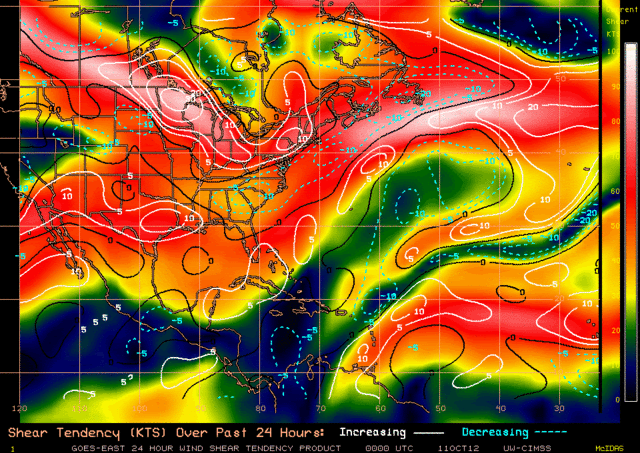
It has a very low shear environment where it's sitting right now and if it moves northeast, the most likely direction when it starts moving, it has a low shear environment ahead of it. Note that this is currrent shear plus tendency to increase or decrease over the last 24 hours, but shear doesn't look to change much over the next 24 hours either.
0 likes
-
ozonepete
- Professional-Met
- Posts: 4743
- Joined: Mon Sep 07, 2009 3:23 pm
- Location: From Ozone Park, NYC / Now in Brooklyn, NY
Re: ATL: INVEST 97L - Discussion
Still looks pretty good. Doesn't look like it's weakening. More important, it doesn't look like it's moving very much. Since it has gotten a little elongated on a north-northeast to south-southwest angle, the worst case scenario for this is if it gets stretched further along that axis. That would kill the symmtery and it could get stretched into a wave and dissipate right into the front. But right now the visuals don't suggest that scenario. It's too far to the south of the tail of the front and still drifting slightly east. I still think the front will leave it behind.
0 likes

Up to 50%
Satellite imagery indicates the small well-defined low pressure system located about 275 miles east of the central Bahamas has
continued to become better organized. Thunderstorm activity has increased near the circulation center over the past several hours
and...if this development trend continues...a tropical depression could form and briefly persist before hostile upper-level winds
cause rapid weakening of the low...or the low merges with a cold front...by this afternoon. This system has a medium chance...50
percent...of becoming a tropical cyclone during the next 48 hours as it moves eastward or southeastward at 5 to 10 mph.
0 likes
-
TropicalAnalystwx13

- Category 5
- Posts: 2109
- Age: 26
- Joined: Tue Jul 19, 2011 8:20 pm
- Location: Wilmington, NC
- Contact:
Who is online
Users browsing this forum: No registered users and 39 guests