ATL: PATTY - Remnants - Discussion
Moderator: S2k Moderators
-
vbhoutex

- Storm2k Executive

- Posts: 28975
- Age: 72
- Joined: Wed Oct 09, 2002 11:31 pm
- Location: Spring Branch area, Houston, TX
- Contact:
Re: ATL: INVEST 97L - Discussion
Several posts were deleted as they had nothing to do with this Invest. You know who you were and you know what they said. Keep the discussion about the subject at hand please.
0 likes
Skywarn, C.E.R.T.
Please click below to donate to STORM2K to help with the expenses of keeping the site going:

Please click below to donate to STORM2K to help with the expenses of keeping the site going:
-
HurricaneAndrew92
Re: ATL: INVEST 97L - Discussion
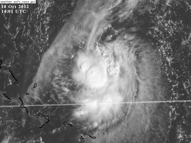
Actually, looks a lot better(outflow, swirl) and there's a "fool's eye" where the center of the storm is. What I mean by that is where it's swirling, it's clear.
0 likes
-
cycloneye

- Admin
- Posts: 139168
- Age: 67
- Joined: Thu Oct 10, 2002 10:54 am
- Location: San Juan, Puerto Rico
Re: ATL: INVEST 97L - Discussion
Down to 10%.
TROPICAL WEATHER OUTLOOK
NWS NATIONAL HURRICANE CENTER MIAMI FL
800 PM EDT SUN OCT 7 2012
FOR THE NORTH ATLANTIC...CARIBBEAN SEA AND THE GULF OF MEXICO...
A TROUGH OF LOW PRESSURE EXTENDING FROM NEAR THE SOUTHEASTERN
BAHAMAS NORTHWARD OVER THE WESTERN ATLANTIC FOR A COUPLE HUNDRED
MILES IS PRODUCING DISORGANIZED CLOUDINESS AND SHOWERS. UPPER-
LEVEL WINDS ARE FORECAST TO BECOME LESS CONDUCIVE FOR DEVELOPMENT
DURING THE NEXT DAY OR TWO AS THE DISTURBANCE MOVES WEST-
NORTHWESTWARD AT ABOUT 10 MPH. THIS SYSTEM HAS A LOW CHANCE...10
PERCENT...OF BECOMING A TROPICAL CYCLONE DURING THE NEXT 48 HOURS.
ELSEWHERE...TROPICAL CYCLONE FORMATION IS NOT EXPECTED DURING THE
NEXT 48 HOURS.
$$
FORECASTER BROWN
0 likes
Visit the Caribbean-Central America Weather Thread where you can find at first post web cams,radars
and observations from Caribbean basin members Click Here
and observations from Caribbean basin members Click Here
-
cycloneye
- Admin
- Posts: 139168
- Age: 67
- Joined: Thu Oct 10, 2002 10:54 am
- Location: San Juan, Puerto Rico
Re: ATL: INVEST 97L - Discussion
A TROUGH OF LOW PRESSURE EXTENDING FROM THE SOUTHEASTERN BAHAMAS
NORTHWARD OVER THE WESTERN ATLANTIC FOR A COUPLE HUNDRED MILES
CONTINUES TO PRODUCE DISORGANIZED SHOWERS AND THUNDERSTORMS.
UPPER-LEVEL WINDS ARE FORECAST TO BECOME LESS CONDUCIVE FOR
DEVELOPMENT AS THE TROUGH MOVES NORTHWESTWARD AT ABOUT 10 MPH
DURING THE NEXT DAY OR TWO. THIS SYSTEM HAS A LOW CHANCE...10
PERCENT...OF BECOMING A TROPICAL CYCLONE DURING THE NEXT 48 HOURS.
0 likes
Visit the Caribbean-Central America Weather Thread where you can find at first post web cams,radars
and observations from Caribbean basin members Click Here
and observations from Caribbean basin members Click Here

Re: ATL: INVEST 97L - Discussion
cycloneye wrote:THIS SYSTEM HAS A LOW CHANCE...10
PERCENT...OF BECOMING A TROPICAL CYCLONE DURING THE NEXT 48 HOURS.
Just as an observation, but little of any concern to anyone other than marine interests, is that 97L looks to have a mid level COC somewhere near a point just north of San Salvadore Island (I think that is the name) in the E. Bahamas. Looks to have a small burst of convection which if could be maintained long enough to fight off increasing upper level shear, might just have a bit more of a shot at consolodating. Looks to have a pretty tight center and vorticity envelope might be small enough, that perhaps something might try to quickly spin up within 24 hours. I still think odds are against plus steering would likely pull it more northward (assuming shear does not rip it apart first. Would'nt shock me if 2:00pm NHC pushed it up to perhaps 30%. For the sake of any potential land impact, I'd probably have a bit more curiosity about 98L than 97L.
0 likes
Personal Forecast Disclaimer:
The posts in this forum are NOT official forecast and should not be used as such. They are just the opinion of the poster and may or may not be backed by sound meteorological data. They are NOT endorsed by any professional institution or storm2k.org. For official information, please refer to the NHC and NWS products.
The posts in this forum are NOT official forecast and should not be used as such. They are just the opinion of the poster and may or may not be backed by sound meteorological data. They are NOT endorsed by any professional institution or storm2k.org. For official information, please refer to the NHC and NWS products.
-
wxman57

- Moderator-Pro Met

- Posts: 22482
- Age: 66
- Joined: Sat Jun 21, 2003 8:06 pm
- Location: Houston, TX (southwest)
Re: ATL: INVEST 97L - Discussion
Surface obs indicate an inverted trof axis (tropical wave) crossing the central Bahamas NE-SW through 24N/74W. Surface pressures are in the 1014-1015mb range. Not TOO much wind shear now, but the shear increases tomorrow night/Wednesday as the upper trof approaches. Narrow window to develop an LLC and become a TD before shear takes its toll. Chances not good.
0 likes
-
Hurricanehink

- S2K Supporter

- Posts: 2023
- Joined: Sun Nov 16, 2003 2:05 pm
- Location: New Jersey
-
cycloneye
- Admin
- Posts: 139168
- Age: 67
- Joined: Thu Oct 10, 2002 10:54 am
- Location: San Juan, Puerto Rico
Re: ATL: INVEST 97L - Discussion
2 PM TWO.
A WEAK AREA OF LOW PRESSURE LOCATED A COUPLE OF HUNDRED MILES
EAST-NORTHEAST OF THE NORTHWESTERN BAHAMAS CONTINUES TO PRODUCE
DISORGANIZED SHOWERS AND THUNDERSTORMS. SIGNIFICANT DEVELOPMENT OF
THIS LOW IS NOT EXPECTED DUE TO STRONG UPPER-LEVEL WINDS. THIS
SYSTEM HAS A LOW CHANCE...10 PERCENT...OF BECOMING A TROPICAL
CYCLONE DURING THE NEXT 48 HOURS AS IT MOVES SLOWLY NORTHEASTWARD.
0 likes
Visit the Caribbean-Central America Weather Thread where you can find at first post web cams,radars
and observations from Caribbean basin members Click Here
and observations from Caribbean basin members Click Here

-
cycloneye
- Admin
- Posts: 139168
- Age: 67
- Joined: Thu Oct 10, 2002 10:54 am
- Location: San Juan, Puerto Rico
Re: ATL: INVEST 97L - Discussion
8 PM TWO.
A WEAK AREA OF LOW PRESSURE LOCATED A COUPLE OF HUNDRED MILES
EAST-NORTHEAST OF THE NORTHWESTERN BAHAMAS CONTINUES TO PRODUCE
DISORGANIZED SHOWERS AND THUNDERSTORMS. SIGNIFICANT DEVELOPMENT OF
THIS LOW IS NOT EXPECTED DUE TO STRONG UPPER-LEVEL WINDS. THIS
SYSTEM HAS A LOW CHANCE...10 PERCENT...OF BECOMING A TROPICAL
CYCLONE DURING THE NEXT 48 HOURS AS IT ACCELERATES NORTHEASTWARD
AND MERGES WITH A FRONTAL ZONE.
0 likes
Visit the Caribbean-Central America Weather Thread where you can find at first post web cams,radars
and observations from Caribbean basin members Click Here
and observations from Caribbean basin members Click Here
-
Blown Away

- S2K Supporter
- Posts: 9863
- Joined: Wed May 26, 2004 6:17 am
Re: ATL: INVEST 97L - Discussion

JB still tweeting about this area.
0 likes
Hurricane Eye Experience: David 79, Irene 99, Frances 04, Jeanne 04, Wilma 05...
Hurricane Brush Experience: Andrew 92, Erin 95, Floyd 99, Matthew 16, Irma 17, Ian 22, Nicole 22…
Hurricane Brush Experience: Andrew 92, Erin 95, Floyd 99, Matthew 16, Irma 17, Ian 22, Nicole 22…

Re: ATL: INVEST 97L - Discussion
Blown Away wrote:
JB still tweeting about this area.
Doesnt he always though?,
0 likes
-
gatorcane

- S2K Supporter
- Posts: 23499
- Age: 46
- Joined: Sun Mar 13, 2005 3:54 pm
- Location: Boca Raton, FL
Very surprised NHC dropped this. Certainly looking better today and looks like it has detached from the front so will be interesting where this will decide to go from here with high pressure building in down the eastern seaboard in the wake of the front, likely SW looking at the latest GFS run.
0 likes
Re: ATL: INVEST 97L - Discussion
If it heads SW check wxman post in the 98l thread so it's doomed
0 likes
-
Hurricanehink
- S2K Supporter
- Posts: 2023
- Joined: Sun Nov 16, 2003 2:05 pm
- Location: New Jersey
-
ozonepete
- Professional-Met

- Posts: 4743
- Joined: Mon Sep 07, 2009 3:23 pm
- Location: From Ozone Park, NYC / Now in Brooklyn, NY
Re: ATL: INVEST 97L - Discussion
Don't know why they dropped this either. It is just about stationary and has an easily visible circulation with 3 hot towers going up near the center and nice outflow on the eastern and western sides. It is pretty much detached from the front now as well and is in a low shear area. I just wouldn't say it should be ignored given those conditions and its small size.
0 likes
-
cycloneye
- Admin
- Posts: 139168
- Age: 67
- Joined: Thu Oct 10, 2002 10:54 am
- Location: San Juan, Puerto Rico
Re: ATL: INVEST 97L - Discussion
Well,at least until the time of this post 97L has not been deactivated by ATCF.
http://ftp.nhc.noaa.gov/atcf/tcweb/
http://ftp.nhc.noaa.gov/atcf/tcweb/
0 likes
Visit the Caribbean-Central America Weather Thread where you can find at first post web cams,radars
and observations from Caribbean basin members Click Here
and observations from Caribbean basin members Click Here
-
cycloneye
- Admin
- Posts: 139168
- Age: 67
- Joined: Thu Oct 10, 2002 10:54 am
- Location: San Juan, Puerto Rico
Re: ATL: INVEST 97L - Discussion
97L is back on TWO.
A WEAK AREA OF LOW PRESSURE LOCATED A COUPLE OF HUNDRED MILES EAST
OF THE CENTRAL BAHAMAS HAS BECOME A LITTLE BETTER DEFINED THIS
AFTERNOON. ENVIRONMENTAL CONDITIONS ARE ONLY MARGIANALLY CONDUCIVE
FOR DEVELOPMENT DURING THE NEXT DAY OR SO BEFORE THE LOW MERGES
WITH A FRONT THURSDAY NIGHT OR FRIDAY. THIS SYSTEM HAS A LOW
CHANCE...10 PERCENT...OF BECOMING A TROPICAL CYCLONE DURING THE
NEXT 48 HOURS AS IT MOVES LITTLE.
0 likes
Visit the Caribbean-Central America Weather Thread where you can find at first post web cams,radars
and observations from Caribbean basin members Click Here
and observations from Caribbean basin members Click Here
-
ozonepete
- Professional-Met
- Posts: 4743
- Joined: Mon Sep 07, 2009 3:23 pm
- Location: From Ozone Park, NYC / Now in Brooklyn, NY
Re: ATL: INVEST 97L - Discussion
Aha! the season of disappearing/reappearing cyclones continues. Not that I expect too much, but it's so small it could make it to TD or TS before the front arrives. Almost no negatives for intensification at the moment as long as it just sits there.
0 likes
Who is online
Users browsing this forum: No registered users and 76 guests