ATL: SANDY - Models
Moderator: S2k Moderators
-
deltadog03

- Professional-Met

- Posts: 3580
- Joined: Tue Jul 05, 2005 6:16 pm
- Location: Macon, GA
-
Hurricaneman

- Category 5

- Posts: 7281
- Age: 43
- Joined: Tue Aug 31, 2004 3:24 pm
- Location: central florida
Re: ATL: SANDY - Models
The Euro seems to have shifted east quite a bit, probably will have landfall farther north
The posts in this forum are NOT official forecast and should not be used as such. They are just the opinion of the poster and may or may not be backed by sound meteorological data. They are NOT endorsed by any professional institution or storm2k.org. For official information, please refer to the NHC and NWS products
The posts in this forum are NOT official forecast and should not be used as such. They are just the opinion of the poster and may or may not be backed by sound meteorological data. They are NOT endorsed by any professional institution or storm2k.org. For official information, please refer to the NHC and NWS products
0 likes

Re: ATL: SANDY - Models
cant get to the models from work....does the new run bring it any closer or further from Hatteras. Not getting much info here from the media, everyone is concentrating on the impact up north.....meanwhile I have flooding problems of my own to worry about. I'm on the south end of Pamlico sound.......... 
0 likes
Ginger-(eye),Dennis,Diana,Kate,Gloria,Charley-(eye),Allison,Arthur,Bertha,Fran,Josephine,Bonnie,Earl,Dennis-(twice),Floyd, Isabel-(eye),Charley,Ophelia-(eyewall),Ernesto,Barry,Hanna,Irene-(eye),Arthur-(eye), Florence, Dorian, and countless depressions, storms, and nor'easters.
-
deltadog03
- Professional-Met
- Posts: 3580
- Joined: Tue Jul 05, 2005 6:16 pm
- Location: Macon, GA

-
somethingfunny

- ChatStaff

- Posts: 3926
- Age: 35
- Joined: Thu May 31, 2007 10:30 pm
- Location: McKinney, Texas
Re: ATL: SANDY - Models
The Euro is explicitly depicting that Sandy will still have a warm core at landfall:

0 likes
I am not a meteorologist, and any posts made by me are not official forecasts or to be interpreted as being intelligent. These posts are just my opinions and are probably silly opinions.

Re: ATL: SANDY - Models
12Z GFS is borderlining a symmetric warming core.
IMHO, very likely once convection picks back up.
Gotta remember, even though the water temps are cooler as Sandy moves north, the upper atmosphere is also cooler.
A cooler upper atmosphere kicks off stronger convection.
http://moe.met.fsu.edu/cyclonephase/gfs ... 612/3.html
IMHO, very likely once convection picks back up.
Gotta remember, even though the water temps are cooler as Sandy moves north, the upper atmosphere is also cooler.
A cooler upper atmosphere kicks off stronger convection.
http://moe.met.fsu.edu/cyclonephase/gfs ... 612/3.html
0 likes
Re: ATL: SANDY - Models
somethingfunny wrote:The Euro is explicitly depicting that Sandy will still have a warm core at landfall:
Check SREF:
A 6C core at 500mb
http://www.spc.noaa.gov/exper/sref/sref ... _MEAN_SD__
0 likes

Re: ATL: SANDY - Models
didnt see the 12Z CMC posted...holding serve...with a NYC/ Long Island entry...
http://moe.met.fsu.edu/cgi-bin/cmctc2.c ... =Animation
http://moe.met.fsu.edu/cgi-bin/cmctc2.c ... =Animation
0 likes
-
GoneBabyGone
- Tropical Storm

- Posts: 101
- Joined: Sat Aug 30, 2008 4:28 pm
Re: ATL: SANDY - Models
Have the models started to move in any one way that's good news or bad news for NYC?
E.g toward VA "good" news...toward NYC bad news. Having trouble following. Don't know which ones are expected to be the most reliable.
E.g toward VA "good" news...toward NYC bad news. Having trouble following. Don't know which ones are expected to be the most reliable.
0 likes
Re: ATL: SANDY - Models
GoneBabyGone wrote:Have the models started to move in any one way that's good news or bad news for NYC?
E.g toward VA "good" news...toward NYC bad news. Having trouble following. Don't know which ones are expected to be the most reliable.
This run was probably a little worse off for NYC...the GFS is slightly north over Long Island Sound rather than N Jersey and the Euro is slightly north over Del. instead of Md./Va. So the midpoint is back in Jersey, so it wouldn't surprise me to see a Jersey landfall at 5 PM.
0 likes
Re: ATL: SANDY - Models
HurrMark wrote:GoneBabyGone wrote:Have the models started to move in any one way that's good news or bad news for NYC?
E.g toward VA "good" news...toward NYC bad news. Having trouble following. Don't know which ones are expected to be the most reliable.
This run was probably a little worse off for NYC...the GFS is slightly north over Long Island Sound rather than N Jersey and the Euro is slightly north over Del. instead of Md./Va. So the midpoint is back in Jersey, so it wouldn't surprise me to see a Jersey landfall at 5 PM.
I'm coming late to today's discussion, but I've tried to stay abreast of the situation the best I can.
I think I might change my handle to the ensemble guy...
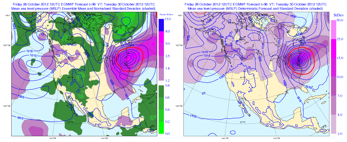
The 51-member ECMWF ensemble forecast at 96 hours (from 12Z) shows "landfall" of the hybrid system at 12Z on Tuesday along the coast of New Jersey.
https://www.e-education.psu.edu/worldof ... ica_96.gif
The left panel is the ensemble mean and the colors indicate the normalized standard deviation. The right panel is a higher resolution forecast with standard deviations indicated in color. The operational ECMWF has been less jumpy than the GFS, so my gut reaction is that its ensemble forecast is also superior.
0 likes
Re: ATL: SANDY - Models
Laplacian wrote:HurrMark wrote:GoneBabyGone wrote:Have the models started to move in any one way that's good news or bad news for NYC?
E.g toward VA "good" news...toward NYC bad news. Having trouble following. Don't know which ones are expected to be the most reliable.
This run was probably a little worse off for NYC...the GFS is slightly north over Long Island Sound rather than N Jersey and the Euro is slightly north over Del. instead of Md./Va. So the midpoint is back in Jersey, so it wouldn't surprise me to see a Jersey landfall at 5 PM.
I'm coming late to today's discussion, but I've tried to stay abreast of the situation the best I can.
I think I might change my handle to the ensemble guy...
The 51-member ECMWF ensemble forecast at 96 hours (from 12Z) shows "landfall" of the hybrid system at 12Z on Tuesday along the coast of New Jersey.
https://www.e-education.psu.edu/worldof ... ica_96.gif
The left panel is the ensemble mean and the colors indicate the normalized standard deviation. The right panel is a higher resolution forecast with standard deviations indicated in color. The operational ECMWF has been less jumpy than the GFS, so my gut reaction is that its ensemble forecast is also superior.
NHC's track still shows it over Delaware.
0 likes
-
somethingfunny
- ChatStaff
- Posts: 3926
- Age: 35
- Joined: Thu May 31, 2007 10:30 pm
- Location: McKinney, Texas
Don't pay attention to the black line. In the cone is in the cone and impacts will still be severe outside of the cone.
0 likes
I am not a meteorologist, and any posts made by me are not official forecasts or to be interpreted as being intelligent. These posts are just my opinions and are probably silly opinions.

Re:
x-y-no wrote:18z GFS has landfall New Nork City at 87 hours. at lest 12 hours of 50 - 60 knot 10-meter winds straight up Long Island Sound ...
worst case scenario....."day after tomorrow" stuff right there...
0 likes
Re: ATL: SANDY - Models
Very strong mid-level warm core near landfall. Click on 30-96 hour animation showing evolution
http://weatherbellmodels.com/weather/gf ... s_anim.gif
http://twitter.com/RyanMaue
http://weatherbellmodels.com/weather/gf ... s_anim.gif
http://twitter.com/RyanMaue
0 likes
-
KBBOCA
- S2K Supporter

- Posts: 1559
- Joined: Fri Sep 05, 2003 5:27 am
- Location: Formerly Boca Raton, often West Africa. Currently Charlotte NC
Are the new 00z models running yet? Is anyone gonna post them?
(sorry, although I'm a longtime member here, I don't know how... and my internet connection is not so great here in Africa to deal with lots of graphics.)
I still can't believe how quiet is in here. What a change from the Isaac models thread. (Maybe since I missed the first few days of posts about this storm due to work and travel, I should go back and reread those posts! It's feeling lonely around here tonight.)
0 likes
Who is online
Users browsing this forum: No registered users and 130 guests