Death toll up to 475
NEW BATAAN, Philippines - Nearly 200,000 people were homeless and 475 confirmed dead after the Philippines' worst typhoon this year, officials said Thursday, as the government appealed for international help.
Typhoon Pablo (international codename Bopha) plowed across Mindanao island on Tuesday, flattening whole towns in its path as hurricane-force winds brought torrential rain that triggered a deadly combination of floods and landslides.
Erinea Cantilla and her family of six walked barefoot for two days in a vain search of food and shelter through a muddy wasteland near the mountainous town of New Bataan after the deluge destroyed their house and banana and cocoa farm.
"Everything we had is gone. The only ones left are dead people," Cantilla told AFP as her husband, three children and a granddaughter reached the outskirts of the town, which itself had been nearly totally obliterated.
The army said it was looking for at least 377 missing people while seeking help for more than 179,000 others who sheltered in schools, gyms and other buildings after losing everything.
Officials said many victims were poor migrants who flocked to landslide-prone sites like New Bataan and the nearby town of Monkayo to farm the lower slopes of mountains or work at unregulated mines in the gold rush area.
Of the dead, 258 were found on the east coast of Mindanao while 191 were recovered in and around New Bataan and Monkayo, said Major General Ariel Bernardo, head of an army division involved in the search.
The civil defense office in Manila said 17 people were killed elsewhere in Mindanao along with nine in the central Visayan islands.
"We still have more than 377 missing and our challenge now is really to try to get to them," he told AFP.
Shell-shocked survivors scrabbled through the rubble of their homes to find anything that could be recovered, as relatives searched for missing family members among mud-caked bodies laid out in rows on tarpaulins.
Civil defense chief Benito Ramos refused to give up hope for the missing.
"There is no time limit -- as long as it takes," he told reporters when asked how long the search and rescue effort would take.
One man was rescued after being trapped for two days under rocks and debris after flash floods swept away his entire family.
Covered in mud and teary-eyed, Carlos Agang recounted how a small community of banana and coconut farmers was devastated as Bopha unleashed a wall of water.
"It's a miracle that I survived, but I might as well be dead," he said.
President Benigno Aquino has sent food and other supplies by ship to 150,000 people on Mindanao's east coast where three towns remain cut off by landslides and wrecked bridges, Interior Secretary Mar Roxas said.
Social Welfare Secretary Corazon Soliman said the government had sought help from the Swiss-based International Organization for Migration to build temporary shelters to ease the pressure on evacuation camps.
"The priority is to build bunkhouses so that there will be shelter for them," she said on ABS-CBN television.
The United States and Japan said they had offered emergency assistance.
Geologist Mahar Lagmay, head of a government project to map out all flood-prone areas of the country, said that while most people in the affected communities were aware of the danger, they did not know where to go for safety.
"Year after year, whenever there is heavy rain that comes to that place, there are landslides and many people die in those mountainous areas," he said.
Workers were struggling to reach villages due to destroyed roads and wrecked bridges, but finding corpses was not a problem due to the overpowering stench everywhere, said Francisco Macalipay, a soldier involved in the rescue.
"Just let your nose lead you to them," he told AFP.
"In a week's time I'm sure the smell of death would force the survivors to flee the town."
WPAC: BOPHA - Remnants
Moderator: S2k Moderators
-
cycloneye

- Admin

- Posts: 139060
- Age: 67
- Joined: Thu Oct 10, 2002 10:54 am
- Location: San Juan, Puerto Rico
Re: WPAC: BOPHA - Typhoon
0 likes
Visit the Caribbean-Central America Weather Thread where you can find at first post web cams,radars
and observations from Caribbean basin members Click Here
and observations from Caribbean basin members Click Here
-
RobWESTPACWX
- WestPACMet

- Posts: 1616
- Joined: Fri Sep 17, 2010 2:26 am
- Location: Tokyo, Japan
- Contact:
Defiantly a TS at this point, still not a storm you would want to drive through with a boat, but it has weakened a lot.
http://www.westernpacificweather.com/20 ... ng-update/
http://www.westernpacificweather.com/20 ... ng-update/
0 likes
Satellites, Charts and Forecasting tools for East Asia at WESTERNPACIFICWEATHER.COM
-
cycloneye
- Admin
- Posts: 139060
- Age: 67
- Joined: Thu Oct 10, 2002 10:54 am
- Location: San Juan, Puerto Rico
Re: WPAC: BOPHA - Typhoon
JMA downgrades to Severe Tropical Storm.
WTPQ20 RJTD 061800
RSMC TROPICAL CYCLONE ADVISORY
NAME STS 1224 BOPHA (1224) DOWNGRADED FROM TY
ANALYSIS
PSTN 061800UTC 13.2N 115.8E FAIR
MOVE NNW SLOWLY
PRES 980HPA
MXWD 060KT
GUST 085KT
50KT 40NM
30KT 120NM
FORECAST
24HF 071800UTC 14.9N 115.6E 70NM 70%
MOVE N SLOWLY
PRES 980HPA
MXWD 060KT
GUST 085KT
48HF 081800UTC 15.4N 115.9E 160NM 70%
MOVE ALMOST STATIONARY
PRES 985HPA
MXWD 055KT
GUST 080KT
72HF 091800UTC 15.5N 116.0E 220NM 70%
MOVE ALMOST STATIONARY
PRES 990HPA
MXWD 050KT
GUST 070KT =
0 likes
Visit the Caribbean-Central America Weather Thread where you can find at first post web cams,radars
and observations from Caribbean basin members Click Here
and observations from Caribbean basin members Click Here
-
supercane4867
- Category 5

- Posts: 4966
- Joined: Wed Nov 14, 2012 10:43 am
Re: WPAC: BOPHA - Severe Tropical Storm
Down to 50 kts by the JTWC, expect to dissipate within 4 days
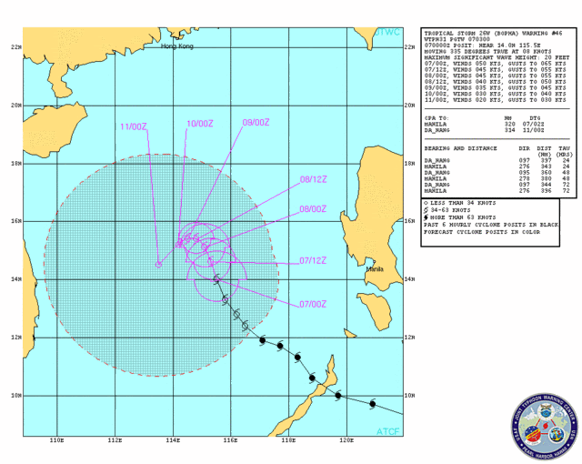
SUBJ: TROPICAL STORM 26W (BOPHA) WARNING NR 045
WTPN31 PGTW 062100
1. TROPICAL STORM 26W (BOPHA) WARNING NR 045
01 ACTIVE TROPICAL CYCLONE IN NORTHWESTPAC
MAX SUSTAINED WINDS BASED ON ONE-MINUTE AVERAGE
WIND RADII VALID OVER OPEN WATER ONLY
---
WARNING POSITION:
061800Z --- NEAR 13.3N 115.8E
MOVEMENT PAST SIX HOURS - 320 DEGREES AT 06 KTS
POSITION ACCURATE TO WITHIN 030 NM
POSITION BASED ON CENTER LOCATED BY SATELLITE
PRESENT WIND DISTRIBUTION:
MAX SUSTAINED WINDS - 050 KT, GUSTS 065 KT
WIND RADII VALID OVER OPEN WATER ONLY
RADIUS OF 034 KT WINDS - 060 NM NORTHEAST QUADRANT
045 NM SOUTHEAST QUADRANT
045 NM SOUTHWEST QUADRANT
060 NM NORTHWEST QUADRANT
REPEAT POSIT: 13.3N 115.8E
---
FORECASTS:
12 HRS, VALID AT:
070600Z --- 13.9N 115.4E
MAX SUSTAINED WINDS - 045 KT, GUSTS 055 KT
WIND RADII VALID OVER OPEN WATER ONLY
RADIUS OF 034 KT WINDS - 050 NM NORTHEAST QUADRANT
040 NM SOUTHEAST QUADRANT
035 NM SOUTHWEST QUADRANT
050 NM NORTHWEST QUADRANT
VECTOR TO 24 HR POSIT: 340 DEG/ 03 KTS
---
24 HRS, VALID AT:
071800Z --- 14.4N 115.2E
MAX SUSTAINED WINDS - 045 KT, GUSTS 055 KT
WIND RADII VALID OVER OPEN WATER ONLY
RADIUS OF 034 KT WINDS - 050 NM NORTHEAST QUADRANT
040 NM SOUTHEAST QUADRANT
040 NM SOUTHWEST QUADRANT
050 NM NORTHWEST QUADRANT
VECTOR TO 36 HR POSIT: 340 DEG/ 03 KTS
---
36 HRS, VALID AT:
080600Z --- 14.9N 115.0E
MAX SUSTAINED WINDS - 040 KT, GUSTS 050 KT
WIND RADII VALID OVER OPEN WATER ONLY
RADIUS OF 034 KT WINDS - 035 NM NORTHEAST QUADRANT
030 NM SOUTHEAST QUADRANT
030 NM SOUTHWEST QUADRANT
035 NM NORTHWEST QUADRANT
VECTOR TO 48 HR POSIT: 325 DEG/ 02 KTS
---
EXTENDED OUTLOOK:
48 HRS, VALID AT:
081800Z --- 15.2N 114.8E
MAX SUSTAINED WINDS - 035 KT, GUSTS 045 KT
WIND RADII VALID OVER OPEN WATER ONLY
VECTOR TO 72 HR POSIT: 250 DEG/ 01 KTS
---
72 HRS, VALID AT:
091800Z --- 15.1N 114.5E
MAX SUSTAINED WINDS - 030 KT, GUSTS 040 KT
WIND RADII VALID OVER OPEN WATER ONLY
DISSIPATING AS A SIGNIFICANT TROPICAL CYCLONE OVER WATER
VECTOR TO 96 HR POSIT: 220 DEG/ 02 KTS
---
LONG RANGE OUTLOOK:
---
96 HRS, VALID AT:
101800Z --- 14.6N 114.1E
MAX SUSTAINED WINDS - 020 KT, GUSTS 030 KT
WIND RADII VALID OVER OPEN WATER ONLY
DISSIPATED AS A SIGNIFICANT TROPICAL CYCLONE OVER WATER
---
REMARKS:
062100Z POSITION NEAR 13.4N 115.7E.
MAXIMUM SIGNIFICANT WAVE HEIGHT AT 061800Z IS 18 FEET.
NEXT WARNINGS AT 070300Z, 070900Z, 071500Z AND 072100Z.
//
BT
#0001
0 likes

Re: WPAC: BOPHA - Severe Tropical Storm

bopha has once again strengthened...an eye has developed, this is most likely a typhoon right now...
0 likes
Remember, all of my post aren't official. For official warnings and discussions, Please refer to your local NWS products...
NWS for the Western Pacific
https://www.weather.gov/gum/
NWS for the Western Pacific
https://www.weather.gov/gum/
-
phwxenthusiast
- Category 2

- Posts: 637
- Joined: Wed Mar 24, 2010 3:10 am
- Location: Holbrook, NY (Long Island)

Re:
phwxenthusiast wrote:seems stronger than a 50-kt storm...
are them meteorologist blind? it seems like they rely on numbers more aka dvorak which is extremely low for most storms...
0 likes
Remember, all of my post aren't official. For official warnings and discussions, Please refer to your local NWS products...
NWS for the Western Pacific
https://www.weather.gov/gum/
NWS for the Western Pacific
https://www.weather.gov/gum/
-
ozonepete
- Professional-Met

- Posts: 4743
- Joined: Mon Sep 07, 2009 3:23 pm
- Location: From Ozone Park, NYC / Now in Brooklyn, NY
Re: WPAC: BOPHA - Severe Tropical Storm
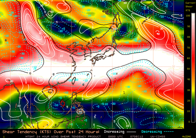
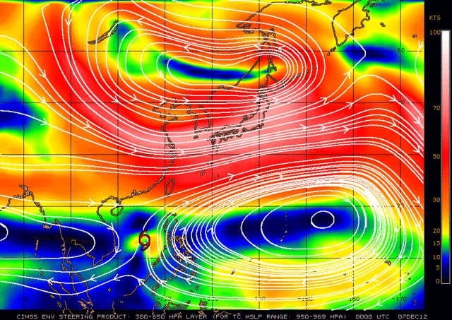
The latest JTWC forecast track for Bopha has it slowing down and gradually weakening over the next few days in the South China Sea (first attachment below.) But I don't see it that way at all. Look at the latest satellite presentation - it sure looks to be intensifying again and the CIMSS ADT numbers are already at 70 mph and 991 mb (not shown). With high SSTs and pretty low shear (attached) I can see Bopha easily getting back up to a 100 knot typhoon which would put it in the 960 mb pressure area. Now look at the CIMSS steering charts based on strength: for a weak TC, pressure at or greater than 1000mb, you can see weak steering currents and then the JTWC track justifies. But the CIMSS steering winds chart for a 100 knot TC with a central pressure anywhere near 960 mb indicates a path to the north and northeast. Supporting that steering scenario are the appearance of the jet stream on the satellite image posted here and the upper air progs (not shown). So it sure looks like Bopha could do a pretty sharp recurve right into the northwestern Philippine coast given the strengthening that is visible on the latest satellite images already and the potential for more strengthening given the favorable environment it's in.
SHEAR and RECENT SHEAR TENDENCY:
STEERING FOR WEAK SYTEMS:
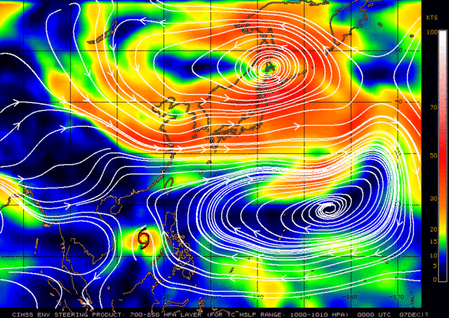
STEERING FOR STRONGER SYSTEMS:
SHEAR and RECENT SHEAR TENDENCY:
STEERING FOR WEAK SYTEMS:
STEERING FOR STRONGER SYSTEMS:
0 likes
-
ozonepete
- Professional-Met
- Posts: 4743
- Joined: Mon Sep 07, 2009 3:23 pm
- Location: From Ozone Park, NYC / Now in Brooklyn, NY
Re: WPAC: BOPHA - Severe Tropical Storm
Btw, there are dry air entrainment issues which the JTWC has talked about. Clearly if dry air wraps into the center it will weaken considerably and will be under the influence of lower level steering currents, but I can't get to this right now. Feel free to jump in since I can't address this until tomorrow. 
0 likes
-
phwxenthusiast
- Category 2
- Posts: 637
- Joined: Wed Mar 24, 2010 3:10 am
- Location: Holbrook, NY (Long Island)
good points there ozonepete... i've been watching the COAMPS model for a few days now and it keeps on showing the system turning northeastward towards Luzon.. at first i dismissed it cause it's showing Bopha re-intensifying into a Cat 2/3... but with the recent trends, i might watch it more carefully...
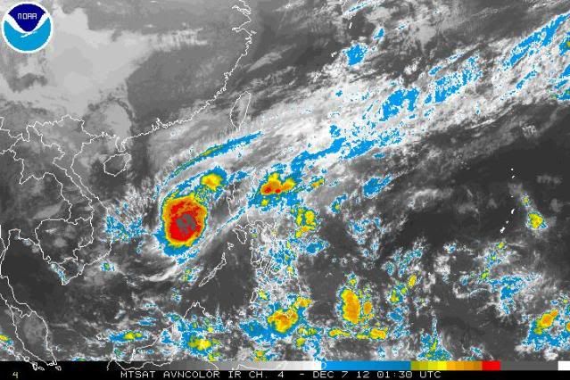
with the recent IR Image (330 UTC) showing the center trying to pop out of the cirrus clouds, i'd be very surprised if they keep it as STS...
Personal Forecast Disclaimer:
The posts in this forum are NOT official forecast and should not be used as such. They are just the opinion of the poster and may or may not be backed by sound meteorological data. They are NOT endorsed by any professional institution or storm2k.org. For official information, please refer to the NHC and NWS products.
0 likes
-
ozonepete
- Professional-Met
- Posts: 4743
- Joined: Mon Sep 07, 2009 3:23 pm
- Location: From Ozone Park, NYC / Now in Brooklyn, NY
Re: WPAC: BOPHA - Severe Tropical Storm
0 likes
-
phwxenthusiast
- Category 2
- Posts: 637
- Joined: Wed Mar 24, 2010 3:10 am
- Location: Holbrook, NY (Long Island)
Re: WPAC: BOPHA - Severe Tropical Storm
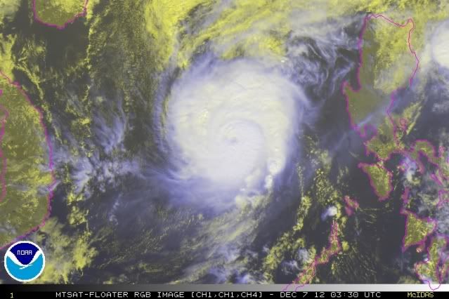
ozonepete wrote::uarrow: Yup. It's intensifying quickly now. From what I can tell dry air is not entraining at all. Dry air would come from the west and the western side of the core is very intact right now. Look at the latest RGB satellite image as daylight has arrived. The eye is becoming quite visible and it once again has very good symmetry. I think a cat 2 is no problem and cat 3 wouldn't surpise me at all. Hopefully it will just clip the northwest corner of the Philippines but it could make a more direct hit.
that's what i'm concerned about.. say it intensifies into a Cat 2/3 by tomorrow; based on the steering layers, then it would have to move more to the northeast towards Luzon... the question is, how fast would it be moving and how strong would it be when it makes its approach??
0 likes
-
ozonepete
- Professional-Met
- Posts: 4743
- Joined: Mon Sep 07, 2009 3:23 pm
- Location: From Ozone Park, NYC / Now in Brooklyn, NY
Re: WPAC: BOPHA - Severe Tropical Storm
phwxenthusiast wrote:ozonepete wrote::uarrow: Yup. It's intensifying quickly now. From what I can tell dry air is not entraining at all. Dry air would come from the west and the western side of the core is very intact right now. Look at the latest RGB satellite image as daylight has arrived. The eye is becoming quite visible and it once again has very good symmetry. I think a cat 2 is no problem and cat 3 wouldn't surpise me at all. Hopefully it will just clip the northwest corner of the Philippines but it could make a more direct hit.
that's what i'm concerned about.. say it intensifies into a Cat 2/3 by tomorrow; based on the steering layers, then it would have to move more to the northeast towards Luzon... the question is, how fast would it be moving and how strong would it be when it makes its approach??
JTWC is a really good organization and will catch this pretty soon if it's developing as we suspect. They have plenty of time to change the forecast if these trends hold up. Let's wait and see what they say in the next advisories.
0 likes
-
mrbagyo

- Category 5
- Posts: 3614
- Age: 31
- Joined: Thu Apr 12, 2012 9:18 am
- Location: 14.13N 120.98E
- Contact:
Re: WPAC: BOPHA - Severe Tropical Storm
ozonepete wrote:phwxenthusiast wrote:ozonepete wrote::uarrow: Yup. It's intensifying quickly now. From what I can tell dry air is not entraining at all. Dry air would come from the west and the western side of the core is very intact right now. Look at the latest RGB satellite image as daylight has arrived. The eye is becoming quite visible and it once again has very good symmetry. I think a cat 2 is no problem and cat 3 wouldn't surpise me at all. Hopefully it will just clip the northwest corner of the Philippines but it could make a more direct hit.
that's what i'm concerned about.. say it intensifies into a Cat 2/3 by tomorrow; based on the steering layers, then it would have to move more to the northeast towards Luzon... the question is, how fast would it be moving and how strong would it be when it makes its approach??
JTWC is a really good organization and will catch this pretty soon if it's developing as we suspect. They have plenty of time to change the forecast if these trends hold up. Let's wait and see what they say in the next advisories.
wow, its returning, and intensifying again.. looks like its being attracted to a frontal system to its northeast. but the dry air might weaken it and the front might soon leave bopha in the SCS.
0 likes
The posts in this forum are NOT official forecast and should not be used as such. They are just the opinion of the poster and may or may not be backed by sound meteorological data. They are NOT endorsed by any professional institution or storm2k.org. For official information, please refer to RSMC, NHC and NWS products.
-
RobWESTPACWX
- WestPACMet
- Posts: 1616
- Joined: Fri Sep 17, 2010 2:26 am
- Location: Tokyo, Japan
- Contact:
At least at this time, I see the euro picks up on this intensification, but then as it gradually works north it weakens out due to an increase in wind shear. That would be very good, but still a heavy rainmaker across Luzon as all the sheared off moisture pushes east.
0 likes
Satellites, Charts and Forecasting tools for East Asia at WESTERNPACIFICWEATHER.COM
-
mrbagyo
- Category 5
- Posts: 3614
- Age: 31
- Joined: Thu Apr 12, 2012 9:18 am
- Location: 14.13N 120.98E
- Contact:
Re: WPAC: BOPHA - Severe Tropical Storm
UW - CIMSS
ADVANCED DVORAK TECHNIQUE
ADT-Version 8.1.3
Tropical Cyclone Intensity Algorithm
----- Current Analysis -----
Date : 07 DEC 2012 Time : 063000 UTC
Lat : 14:43:36 N Lon : 115:54:17 E
CI# /Pressure/ Vmax
4.6 / 978.0mb/ 79.6kt
Final T# Adj T# Raw T#
4.6 5.4 7.0
Estimated radius of max. wind based on IR : 15 km
Center Temp : +9.0C Cloud Region Temp : -76.3C
Scene Type : EYE
Positioning Method : RING/SPIRAL COMBINATION
Ocean Basin : WEST PACIFIC
Dvorak CI > MSLP Conversion Used : PACIFIC
Tno/CI Rules : Constraint Limits : 1.7T/6hr
Weakening Flag : OFF
Rapid Dissipation Flag : OFF
C/K/Z MSLP Estimate Inputs :
- Average 34 knot radii : 67km
- Environmental MSLP : 1011mb
Satellite Viewing Angle : 32.6 degrees
0 likes
The posts in this forum are NOT official forecast and should not be used as such. They are just the opinion of the poster and may or may not be backed by sound meteorological data. They are NOT endorsed by any professional institution or storm2k.org. For official information, please refer to RSMC, NHC and NWS products.
-
RobWESTPACWX
- WestPACMet
- Posts: 1616
- Joined: Fri Sep 17, 2010 2:26 am
- Location: Tokyo, Japan
- Contact:
Re: WPAC: BOPHA - Severe Tropical Storm
DVORAK now has it at a Cat 2 typhoon.
http://www.westernpacificweather.com/2012/12/07/bophapablo-resurrect-07-dec-2012/
http://www.westernpacificweather.com/2012/12/07/bophapablo-resurrect-07-dec-2012/
0 likes
Satellites, Charts and Forecasting tools for East Asia at WESTERNPACIFICWEATHER.COM
-
dexterlabio
- Category 5
- Posts: 3406
- Joined: Sat Oct 24, 2009 11:50 pm
Re: WPAC: BOPHA - Severe Tropical Storm
is this thing not over yet? i was shocked to see that eye almost returning. and JMA has it as a 70kt typhoon...officially back to typhoon strrength, and I think JTWC would see that later on. It sucks though the network we have here now doesn't allow me to open the JTWC website.
0 likes
Personal Forecast Disclaimer:
The posts in this forum are NOT official forecast and should not be used as such. They are just the opinion of the poster and may or may not be backed by sound meteorological data. They are NOT endorsed by any professional institution or storm2k.org. For official information, please refer to the NHC and NWS products.
The posts in this forum are NOT official forecast and should not be used as such. They are just the opinion of the poster and may or may not be backed by sound meteorological data. They are NOT endorsed by any professional institution or storm2k.org. For official information, please refer to the NHC and NWS products.
-
dexterlabio
- Category 5
- Posts: 3406
- Joined: Sat Oct 24, 2009 11:50 pm
for all our experts, what do you think about the chance of Bopha affecting the Philippines again? Actually I was thinking the same idea as ozonepete the past days, but that idea is only if Bopha regained a stronger intensity and then would be steered northeastwards. People in the northern Philippines probably thinks this storm is over now as we aid the typhoon victims from the south.
0 likes
Personal Forecast Disclaimer:
The posts in this forum are NOT official forecast and should not be used as such. They are just the opinion of the poster and may or may not be backed by sound meteorological data. They are NOT endorsed by any professional institution or storm2k.org. For official information, please refer to the NHC and NWS products.
The posts in this forum are NOT official forecast and should not be used as such. They are just the opinion of the poster and may or may not be backed by sound meteorological data. They are NOT endorsed by any professional institution or storm2k.org. For official information, please refer to the NHC and NWS products.
-
francis327
- WesternPacificWeather.com

- Posts: 81
- Joined: Mon Nov 07, 2011 9:04 am
- Location: Kuala Lumpur, Malaysia
- Contact:
JMA somewhat have it continue to weaken in 24 hours
WTPQ50 RJTD 070600
RSMC TROPICAL CYCLONE ADVISORY
NAME TY 1224 BOPHA (1224) UPGRADED FROM STS
ANALYSIS
PSTN 070600UTC 14.6N 115.9E GOOD
MOVE N 07KT
PRES 970HPA
MXWD 070KT
GUST 100KT
50KT 40NM
30KT 120NM
FORECAST
24HF 080600UTC 16.2N 116.2E 85NM 70%
MOVE N SLOWLY
PRES 980HPA
MXWD 060KT
GUST 085KT
48HF 090600UTC 16.8N 116.9E 160NM 70%
MOVE ALMOST STATIONARY
PRES 985HPA
MXWD 055KT
GUST 080KT
72HF 100600UTC 16.7N 117.6E 220NM 70%
MOVE ALMOST STATIONARY
PRES 994HPA
MXWD 045KT
GUST 065KT
96HF 110600UTC 16.7N 117.7E 240NM 70%
MOVE ALMOST STATIONARY
120HF 120600UTC 16.7N 117.8E 300NM 70%
MOVE ALMOST STATIONARY =
0 likes
WESTERNPACIFICWEATHER.COM
Who is online
Users browsing this forum: No registered users and 102 guests