
ClarkEligue wrote:Got this off facebook. Its from one of the people from Cateel. He, along with other Cateel residents that work and live somewhere else in the Philippines/World are having no contact on what happened there.
Geo speak, Cateel got the northern eyewall during landfall.
To all my friends who have a good heart: Our hometown in Cateel, Davao Oriental is severely devastated by TYPHOON PABLO, it's beyond words to describe the damage. Victims describe it as the end of the world. It is located 30 minute drive from the site of typhoon Pablo landfall. We all lost our homes, we have not accounted completely all our immediate families. No structures can serve as evacuation center as all buildings are severely wrecked and damaged including among others churches, hospitals and schools. Casualties to date is 56 and is increasing. Injured persons are lying in the streets. Roads going inside the town are un-passable making rescue and relief efforts very hard. People now are starving with no place to go. Electricity and cellfon sites are severely damaged making communication very difficult. No media group has ever entered the town. It has been isolated for more that 30 hours already.
Im knocking on you hearts to pls HELP my family and kababayans in my hometown of Cateel, Davao Oriental. WE need among others clean water, ready to eat food, clothes, shelter and medicines, toiletries. I hope the authorities will mobilize quickly to get inside the town. We need you. HELP us pls!!! Oh LORD GOD..pls help us....People are starving and homeless and nowhere to go.
WPAC: BOPHA - Remnants
Moderator: S2k Moderators
Re: WPAC: BOPHA - Typhoon
0 likes
Remember, all of my post aren't official. For official warnings and discussions, Please refer to your local NWS products...
NWS for the Western Pacific
https://www.weather.gov/gum/
NWS for the Western Pacific
https://www.weather.gov/gum/
Re: WPAC: BOPHA - Typhoon
HurricaneBill wrote:euro6208 wrote:what a way to end this active destructive season with a record, destructive super typhoon...
I wouldn't let my guard down. Typhoons that hit the Philippines during late fall/early winter sometimes come in pairs. By that, I mean another typhoon could hit a week or two afterwards.
Examples:
1970: Joan and Kate
1980: Joe and Kim
1988: Ruby and Skip
1998: Zeb and Babs
2004: Muifa and Nanmadol
2006: Cimaron and Chebi, Durian and Utor
2011: Nesat and Nalgae

a disturbance is just to the east of mindanao...more rain headed for flood stricken areas...
0 likes
Remember, all of my post aren't official. For official warnings and discussions, Please refer to your local NWS products...
NWS for the Western Pacific
https://www.weather.gov/gum/
NWS for the Western Pacific
https://www.weather.gov/gum/
Re: WPAC: BOPHA - Typhoon

some slight strengthening is forecast before bopha starts to dissipate...
WTPN31 PGTW 051500
MSGID/GENADMIN/JOINT TYPHOON WRNCEN PEARL HARBOR HI//
SUBJ/TROPICAL CYCLONE WARNING//
RMKS/
1. TYPHOON 26W (BOPHA) WARNING NR 040
01 ACTIVE TROPICAL CYCLONE IN NORTHWESTPAC
MAX SUSTAINED WINDS BASED ON ONE-MINUTE AVERAGE
WIND RADII VALID OVER OPEN WATER ONLY
---
WARNING POSITION:
051200Z --- NEAR 11.3N 117.8E
MOVEMENT PAST SIX HOURS - 310 DEGREES AT 11 KTS
POSITION ACCURATE TO WITHIN 060 NM
POSITION BASED ON CENTER LOCATED BY SATELLITE
PRESENT WIND DISTRIBUTION:
MAX SUSTAINED WINDS - 075 KT, GUSTS 090 KT
WIND RADII VALID OVER OPEN WATER ONLY
RADIUS OF 064 KT WINDS - 025 NM NORTHEAST QUADRANT
020 NM SOUTHEAST QUADRANT
020 NM SOUTHWEST QUADRANT
025 NM NORTHWEST QUADRANT
RADIUS OF 050 KT WINDS - 040 NM NORTHEAST QUADRANT
030 NM SOUTHEAST QUADRANT
030 NM SOUTHWEST QUADRANT
040 NM NORTHWEST QUADRANT
RADIUS OF 034 KT WINDS - 095 NM NORTHEAST QUADRANT
070 NM SOUTHEAST QUADRANT
060 NM SOUTHWEST QUADRANT
080 NM NORTHWEST QUADRANT
REPEAT POSIT: 11.3N 117.8E
---
FORECASTS:
12 HRS, VALID AT:
060000Z --- 12.1N 116.4E
MAX SUSTAINED WINDS - 075 KT, GUSTS 090 KT
WIND RADII VALID OVER OPEN WATER ONLY
RADIUS OF 064 KT WINDS - 025 NM NORTHEAST QUADRANT
020 NM SOUTHEAST QUADRANT
020 NM SOUTHWEST QUADRANT
025 NM NORTHWEST QUADRANT
RADIUS OF 050 KT WINDS - 040 NM NORTHEAST QUADRANT
030 NM SOUTHEAST QUADRANT
030 NM SOUTHWEST QUADRANT
040 NM NORTHWEST QUADRANT
RADIUS OF 034 KT WINDS - 095 NM NORTHEAST QUADRANT
070 NM SOUTHEAST QUADRANT
060 NM SOUTHWEST QUADRANT
080 NM NORTHWEST QUADRANT
VECTOR TO 24 HR POSIT: 310 DEG/ 06 KTS
---
24 HRS, VALID AT:
061200Z --- 12.8N 115.5E
MAX SUSTAINED WINDS - 080 KT, GUSTS 100 KT
WIND RADII VALID OVER OPEN WATER ONLY
RADIUS OF 064 KT WINDS - 025 NM NORTHEAST QUADRANT
020 NM SOUTHEAST QUADRANT
020 NM SOUTHWEST QUADRANT
025 NM NORTHWEST QUADRANT
RADIUS OF 050 KT WINDS - 040 NM NORTHEAST QUADRANT
030 NM SOUTHEAST QUADRANT
030 NM SOUTHWEST QUADRANT
040 NM NORTHWEST QUADRANT
RADIUS OF 034 KT WINDS - 095 NM NORTHEAST QUADRANT
070 NM SOUTHEAST QUADRANT
060 NM SOUTHWEST QUADRANT
080 NM NORTHWEST QUADRANT
VECTOR TO 36 HR POSIT: 315 DEG/ 03 KTS
---
36 HRS, VALID AT:
070000Z --- 13.3N 115.0E
MAX SUSTAINED WINDS - 085 KT, GUSTS 105 KT
WIND RADII VALID OVER OPEN WATER ONLY
RADIUS OF 064 KT WINDS - 025 NM NORTHEAST QUADRANT
020 NM SOUTHEAST QUADRANT
020 NM SOUTHWEST QUADRANT
025 NM NORTHWEST QUADRANT
RADIUS OF 050 KT WINDS - 040 NM NORTHEAST QUADRANT
030 NM SOUTHEAST QUADRANT
030 NM SOUTHWEST QUADRANT
040 NM NORTHWEST QUADRANT
RADIUS OF 034 KT WINDS - 095 NM NORTHEAST QUADRANT
070 NM SOUTHEAST QUADRANT
060 NM SOUTHWEST QUADRANT
080 NM NORTHWEST QUADRANT
VECTOR TO 48 HR POSIT: 315 DEG/ 01 KTS
---
EXTENDED OUTLOOK:
48 HRS, VALID AT:
071200Z --- 13.5N 114.8E
MAX SUSTAINED WINDS - 085 KT, GUSTS 105 KT
WIND RADII VALID OVER OPEN WATER ONLY
RADIUS OF 064 KT WINDS - 025 NM NORTHEAST QUADRANT
020 NM SOUTHEAST QUADRANT
020 NM SOUTHWEST QUADRANT
025 NM NORTHWEST QUADRANT
RADIUS OF 050 KT WINDS - 040 NM NORTHEAST QUADRANT
030 NM SOUTHEAST QUADRANT
030 NM SOUTHWEST QUADRANT
040 NM NORTHWEST QUADRANT
RADIUS OF 034 KT WINDS - 095 NM NORTHEAST QUADRANT
070 NM SOUTHEAST QUADRANT
060 NM SOUTHWEST QUADRANT
080 NM NORTHWEST QUADRANT
VECTOR TO 72 HR POSIT: 315 DEG/ 01 KTS
---
72 HRS, VALID AT:
081200Z --- 13.8N 114.5E
MAX SUSTAINED WINDS - 075 KT, GUSTS 090 KT
WIND RADII VALID OVER OPEN WATER ONLY
RADIUS OF 064 KT WINDS - 025 NM NORTHEAST QUADRANT
020 NM SOUTHEAST QUADRANT
020 NM SOUTHWEST QUADRANT
025 NM NORTHWEST QUADRANT
RADIUS OF 050 KT WINDS - 040 NM NORTHEAST QUADRANT
030 NM SOUTHEAST QUADRANT
030 NM SOUTHWEST QUADRANT
040 NM NORTHWEST QUADRANT
RADIUS OF 034 KT WINDS - 095 NM NORTHEAST QUADRANT
070 NM SOUTHEAST QUADRANT
060 NM SOUTHWEST QUADRANT
080 NM NORTHWEST QUADRANT
VECTOR TO 96 HR POSIT: 315 DEG/ 01 KTS
---
LONG RANGE OUTLOOK:
---
96 HRS, VALID AT:
091200Z --- 14.0N 114.3E
MAX SUSTAINED WINDS - 055 KT, GUSTS 070 KT
WIND RADII VALID OVER OPEN WATER ONLY
VECTOR TO 120 HR POSIT: 305 DEG/ 01 KTS
---
120 HRS, VALID AT:
101200Z --- 14.2N 114.0E
MAX SUSTAINED WINDS - 035 KT, GUSTS 045 KT
WIND RADII VALID OVER OPEN WATER ONLY
---
REMARKS:
051500Z POSITION NEAR 11.5N 117.4E.
TYPHOON (TY) 26W (BOPHA) LOCATED APPROXIMATELY 270 NM SOUTHWEST OF
MANILA, PHILLIPINES. HAS TRACKED NORTHWESTWARD AT 11 KNOTS OVER THE
PAST SIX HOURS. MAXIMUM SIGNIFICANT WAVE HEIGHT AT 051200Z IS 26
FEET. NEXT WARNINGS AT 052100Z, 060300Z, 060900Z AND 061500Z.
//
NNNN
WDPN31 PGTW 051500
MSGID/GENADMIN/JOINT TYPHOON WRNCEN PEARL HARBOR HI//
SUBJ/PROGNOSTIC REASONING FOR TYPHOON 26W (BOPHA) WARNING NR 40//
RMKS/
1. FOR METEOROLOGISTS.
2. 6 HOUR SUMMARY AND ANALYSIS.
TYPHOON 26W (BOPHA) LOCATED APPROXIMATELY 270 NM SOUTHWEST
OF MANILA, PHILIPPINES HAS TRACKED NORTHWESTWARD AT 11 KNOTS
OVER THE PAST SIX HOURS. ANIMATED MULTISPECTRAL SATELLITE IMAGERY
(MSI) SHOWS DEEP CONVECTION HAS DECREASED OVER THE LOW-LEVEL
CIRCULATION CENTER (LLCC) DURING THE PAST FEW HOURS. HOWEVER, A
TIGHTLY CURVED BAND OF CONVECTION REMAINS ALONG THE WESTERN AND
NORTHERN HALVES OF THE SYSTEM ALONG WITH A RECENT INCREASE IN
CONVECTION IN THE SOUTHEASTERN QUADRANT. THE CURRENT POSITION IS
BASED ON THE MSI IMAGERY, A 05/1208Z SSMIS IMAGE, AND PGTW AND RJTD
FIX POSITIONS. THE CURRENT INTENSITY IS BASED ON DVORAK CURRENT
INTENSITY ESTIMATES OF 77 KNOTS FROM PGTW AND RJTD. UPPER-LEVEL
ANALYSIS INDICATES TY 26W IS LOCATED SOUTHEAST OF A COL REGION
BETWEEN THE SUBTROPICAL RIDGES CENTERED TO THE EAST AND WEST.
VERTICAL WIND SHEAR (VWS) IS CURRENTLY WEAK (10 TO 15 KNOTS), AND
RECENT WATER VAPOR IMAGERY INDICATES OUTFLOW REMAINS GOOD WITH A
STRONG POLEWARD CHANNEL CONTINUING TO TAP INTO THE STRONG
WESTERLIES. TY 26W IS CURRENTLY STEERING ALONG THE SOUTHWESTERN
PERIPHERY OF THE EASTERN LOBE OF THE SUBTROPICAL RIDGE (STR) AND IS
SLOWLY APPROACHING THE COL REGION.
3. FORECAST REASONING.
A. NO CHANGE TO THE FORECAST PHILOSOPHY SINCE THE PREVIOUS
PROGNOSTIC REASONING MESSAGE.
B. TY 26W IS FORECAST TO CONTINUE TRACKING GENERALLY
WEST-NORTHWESTWARD ALONG THE SOUTHWESTERN PERIPHERY OF THE EASTERN
STR TOWARDS THE COL. AS THE SYSTEM APPROACHES THE COL REGION AFTER
TAU 24, FORWARD TRACK MOTION IS EXPECTED TO DECREASE SIGNIFICANTLY.
BY TAU 48, TY 26W IS EXPECTED TO BECOME QUASI-STATIONARY AND TAKE ON
AN ERRATIC MOTION. DUE TO THE WEAK STEERING ENVIRONMENT, DYNAMIC
MODELS ARE HAVING DIFFICULTY RESOLVING A COHERENT OR CONSISTENT
TRACK. SLIGHT INTENSIFICATION MAY OCCUR DURING THE NEXT 48 HOURS DUE
TO FAVORABLE SEA SURFACE TEMPERATURES AND UPPER LEVEL OUTFLOW, BUT
BY TAU 72 A WEAKENING TREND SHOULD BEGIN AS OCEAN HEAT CONTENT
DECREASES, VWS INCREASES, AND A NORTHEAST MONSOON SURGE BEGINS
TO PUSH INTO THE SOUTH CHINA SEA.
C. AFTER TAU 72, TY 26W IS EXPECTED TO INTERACT WITH THE STRONG
NORTHEAST MONSOON SURGE AND REMAIN IN A VERY WEAK STEERING
ENVIRONMENT UNDERNEATH THE UPPER LEVEL COL REGION. THE SYSTEM IS
EXPECTED TO CONTINUE TRACKING SLOWLY AND ERRATICALLY WITH THE
POTENTIAL FOR A LOOPING MOTION. DUE TO THE HIGH UNCERTAINTY OF
MOTION ASSOCIATED WITH THE VERY WEAK STEERING PATTERN, THE CURRENT
FORECAST PHILOSOPHY IS TO KEEP TRACK SPEEDS SLOW AND WESTWARD TO
SOUTHWESTWARD AS THE SYSTEM COMES UNDER THE INFLUENCE OF A STRONG
NORTHEASTERLY SURGE. MODEL GUIDANCE CONTINUES TO BE SPREAD AFTER TAU
24, RANGING FROM AN UNLIKELY WBAR SOLUTION RECURVING THE SYSTEM INTO
THE STRONG WESTERLIES TO A LOOPING THEN SOUTHWESTWARD TRACK
INDICATED BY NGPS, GFS, AND ECMWF. THE OFFICIAL JTWC TRACK FORECAST
REMAINS CONSISTENT WITH THE PREVIOUS FORECAST WITH SLOW TRACK SPEEDS
INDICATING QUASI-STATIONARY MOVEMENT IN THE EXTENDED FORECAST AND A
GRADUAL WEAKENING TREND. DUE TO THE LARGE SPREAD IN MODEL GUIDANCE,
TRACK CONFIDENCE REMAINS LOW.//
NNNN
0 likes
Remember, all of my post aren't official. For official warnings and discussions, Please refer to your local NWS products...
NWS for the Western Pacific
https://www.weather.gov/gum/
NWS for the Western Pacific
https://www.weather.gov/gum/
-
supercane4867
- Category 5

- Posts: 4966
- Joined: Wed Nov 14, 2012 10:43 am
Re: WPAC: BOPHA - Typhoon
Bopha is trying to rebuild the eyewall, this could led to some slight strengthening but time is running out

0 likes
-
wxman57

- Moderator-Pro Met

- Posts: 22480
- Age: 66
- Joined: Sat Jun 21, 2003 8:06 pm
- Location: Houston, TX (southwest)
Re: WPAC: BOPHA - Typhoon
It sure doesn't look like a typhoon now. I think Dvorak estimates are a good bit too high.
0 likes
-
supercane4867
- Category 5
- Posts: 4966
- Joined: Wed Nov 14, 2012 10:43 am
Re: WPAC: BOPHA - Typhoon
T3.5 is not a typhoon, Bopha could be degrade to a TS in the next advisory
TPPN10 PGTW 051815
A. TYPHOON 26W (BOPHA)
B. 05/1730Z
C. 11.4N
D. 117.6E
E. FIVE/MTSAT
F. T3.5/4.0/W0.5/24HRS STT: W0.5/03HRS
G. IR/EIR
H. REMARKS: 47A/PBO PTLY XPSD LLCC/ANMTN. .75 WRAP YIELDS A DT
OF 3.0. MET AND PT WERE 3.5. DBO PT AS PRTLY XPSD LLCC MAKES IT
DIFFICULT TO ASSESS HOW MUCH CONVECTION IS WRAPPING THE LLCC
WITH HIGH CONFIDENCE.
I. ADDITIONAL POSITIONS: NONE
ADT is just being silly
UW - CIMSS
ADVANCED DVORAK TECHNIQUE
ADT-Version 8.1.3
Tropical Cyclone Intensity Algorithm
----- Current Analysis -----
Date : 05 DEC 2012 Time : 183000 UTC
Lat : 11:17:09 N Lon : 117:26:07 E
CI# /Pressure/ Vmax
4.9 / 973.8mb/ 87.4kt
Final T# Adj T# Raw T#
4.3 4.2 3.9
Center Temp : -82.9C Cloud Region Temp : -74.6C
Scene Type : UNIFORM CDO CLOUD REGION
0 likes


Re: WPAC: BOPHA - Typhoon
I do not have too much to add at present. One of my wife's cousins reports much higher water levels than from Washi (Sendong) last year, which did not reach their house. She describes her house as "a submarine" this time -- completely submerged, evidently. I'm not sure of the location - will have to ask my wife when she gets back in. Another cousin, near Valencia, I think, lost some livestock in flooding, but is himself ok. Yet another cousin, about halfway between Cateel and Valencia has not been heard from, but not much news is getting out from that area, yet.
I did see this in a Reuters report:
http://uk.news.yahoo.com/philippines-bi ... 14082.html
(edit - grammar)
I did see this in a Reuters report:
"The waters came so suddenly and unexpectedly, and the winds were so fierce," the Compostela Valley governor, Arthur Uy, told Reuters by telephone.
He said irrigation reservoirs on top of mountains had given way sending large volumes of water down to the valleys. Torrential rain often triggers landslides down slopes stripped of their forest cover.
http://uk.news.yahoo.com/philippines-bi ... 14082.html
(edit - grammar)
0 likes
"Normal" is Chicago under a mile of ice.
-
dexterlabio
- Category 5
- Posts: 3406
- Joined: Sat Oct 24, 2009 11:50 pm
Re: WPAC: BOPHA - Typhoon
All agencies are having a hard time pinpointing the center and it is still called a typhoon. I believe this is already a TS even last night.
Some new stories...I heard from the news that people in Mindanao heeded the call for evacuation before that morning of December 4. However, the evacuation centers were the ones swept away by the strong winds and the villages were hit by flashfloods, there were no place to go. So the evacuees were swept away altogether.
Some new stories...I heard from the news that people in Mindanao heeded the call for evacuation before that morning of December 4. However, the evacuation centers were the ones swept away by the strong winds and the villages were hit by flashfloods, there were no place to go. So the evacuees were swept away altogether.
0 likes
Personal Forecast Disclaimer:
The posts in this forum are NOT official forecast and should not be used as such. They are just the opinion of the poster and may or may not be backed by sound meteorological data. They are NOT endorsed by any professional institution or storm2k.org. For official information, please refer to the NHC and NWS products.
The posts in this forum are NOT official forecast and should not be used as such. They are just the opinion of the poster and may or may not be backed by sound meteorological data. They are NOT endorsed by any professional institution or storm2k.org. For official information, please refer to the NHC and NWS products.
Re: WPAC: BOPHA - Typhoon
A few more pics here (hope this has not already been posted):
http://www.bbc.co.uk/news/world-asia-20599491
http://www.bbc.co.uk/news/world-asia-20599491
0 likes
"Normal" is Chicago under a mile of ice.
Re: WPAC: BOPHA - Typhoon
dexterlabio wrote:All agencies are having a hard time pinpointing the center and it is still called a typhoon. I believe this is already a TS even last night.
Some new stories...I heard from the news that people in Mindanao heeded the call for evacuation before that morning of December 4. However, the evacuation centers were the ones swept away by the strong winds and the villages were hit by flashfloods, there were no place to go. So the evacuees were swept away altogether.
Yes, and a few minutes ago I read:
"In a separate incident, villagers and soldiers who formed part of the rescue effort all died when the truck they were in was washed away in the flooding."
http://uk.news.yahoo.com/typhoon-bopha- ... 49837.html
My wife had some impressive video stuff she was watching on her Facebook acct., but I don't know if it can be easily moved here. (Another "I'll ask her when she gets home" as I don't use Facebook or other "social media" myself - I just don't usually have the time for it.)
Bad, bad stuff...
0 likes
"Normal" is Chicago under a mile of ice.

Thank goodness this monster of a typhoon is coming to a close over open water. Devastating storm. 
0 likes
Personal Forecast Disclaimer:
The posts in this forum are NOT official forecast and should not be used as such. They are just the opinion of the poster and may or may not be backed by sound meteorological data. They are NOT endorsed by any professional institution or storm2k.org.
Hope this helped
The posts in this forum are NOT official forecast and should not be used as such. They are just the opinion of the poster and may or may not be backed by sound meteorological data. They are NOT endorsed by any professional institution or storm2k.org.
Hope this helped
Re: WPAC: BOPHA - Typhoon
Baganga, a little south of Cateel (just about at the center of the landfall, I guess?), looks to be pretty well wiped out, too. It is, or was, a town of 43k.
"Len Sy Iturralde" has posted many pics on Facebook. Devastating indeed...
"Len Sy Iturralde" has posted many pics on Facebook. Devastating indeed...
0 likes
"Normal" is Chicago under a mile of ice.
-
CrazyC83
- Professional-Met

- Posts: 33393
- Joined: Tue Mar 07, 2006 11:57 pm
- Location: Deep South, for the first time!
Re: WPAC: BOPHA - Typhoon
dexterlabio wrote:All agencies are having a hard time pinpointing the center and it is still called a typhoon. I believe this is already a TS even last night.
Some new stories...I heard from the news that people in Mindanao heeded the call for evacuation before that morning of December 4. However, the evacuation centers were the ones swept away by the strong winds and the villages were hit by flashfloods, there were no place to go. So the evacuees were swept away altogether.
That shows that a Category 5 cannot easily be dealt with in any case. Similar to the Joplin tornado, they tried to be safe but were outsmarted by Mother Nature.
0 likes
Re: WPAC: BOPHA - Typhoon

WTPN31 PGTW 060300
MSGID/GENADMIN/JOINT TYPHOON WRNCEN PEARL HARBOR HI//
SUBJ/TROPICAL CYCLONE WARNING//
RMKS/
1. TYPHOON 26W (BOPHA) WARNING NR 042
01 ACTIVE TROPICAL CYCLONE IN NORTHWESTPAC
MAX SUSTAINED WINDS BASED ON ONE-MINUTE AVERAGE
WIND RADII VALID OVER OPEN WATER ONLY
---
WARNING POSITION:
060000Z --- NEAR 11.9N 117.1E
MOVEMENT PAST SIX HOURS - 290 DEGREES AT 06 KTS
POSITION ACCURATE TO WITHIN 060 NM
POSITION BASED ON CENTER LOCATED BY SATELLITE
PRESENT WIND DISTRIBUTION:
MAX SUSTAINED WINDS - 065 KT, GUSTS 080 KT
WIND RADII VALID OVER OPEN WATER ONLY
RADIUS OF 050 KT WINDS - 040 NM NORTHEAST QUADRANT
030 NM SOUTHEAST QUADRANT
030 NM SOUTHWEST QUADRANT
040 NM NORTHWEST QUADRANT
RADIUS OF 034 KT WINDS - 095 NM NORTHEAST QUADRANT
070 NM SOUTHEAST QUADRANT
060 NM SOUTHWEST QUADRANT
080 NM NORTHWEST QUADRANT
REPEAT POSIT: 11.9N 117.1E
---
FORECASTS:
12 HRS, VALID AT:
061200Z --- 12.5N 116.2E
MAX SUSTAINED WINDS - 065 KT, GUSTS 080 KT
WIND RADII VALID OVER OPEN WATER ONLY
RADIUS OF 050 KT WINDS - 040 NM NORTHEAST QUADRANT
030 NM SOUTHEAST QUADRANT
030 NM SOUTHWEST QUADRANT
040 NM NORTHWEST QUADRANT
RADIUS OF 034 KT WINDS - 095 NM NORTHEAST QUADRANT
070 NM SOUTHEAST QUADRANT
060 NM SOUTHWEST QUADRANT
080 NM NORTHWEST QUADRANT
VECTOR TO 24 HR POSIT: 300 DEG/ 04 KTS
---
24 HRS, VALID AT:
070000Z --- 12.9N 115.5E
MAX SUSTAINED WINDS - 070 KT, GUSTS 085 KT
WIND RADII VALID OVER OPEN WATER ONLY
RADIUS OF 064 KT WINDS - 015 NM NORTHEAST QUADRANT
010 NM SOUTHEAST QUADRANT
010 NM SOUTHWEST QUADRANT
015 NM NORTHWEST QUADRANT
RADIUS OF 050 KT WINDS - 045 NM NORTHEAST QUADRANT
040 NM SOUTHEAST QUADRANT
040 NM SOUTHWEST QUADRANT
045 NM NORTHWEST QUADRANT
RADIUS OF 034 KT WINDS - 105 NM NORTHEAST QUADRANT
090 NM SOUTHEAST QUADRANT
085 NM SOUTHWEST QUADRANT
095 NM NORTHWEST QUADRANT
VECTOR TO 36 HR POSIT: 310 DEG/ 04 KTS
---
36 HRS, VALID AT:
071200Z --- 13.4N 114.9E
MAX SUSTAINED WINDS - 070 KT, GUSTS 085 KT
WIND RADII VALID OVER OPEN WATER ONLY
RADIUS OF 064 KT WINDS - 015 NM NORTHEAST QUADRANT
015 NM SOUTHEAST QUADRANT
015 NM SOUTHWEST QUADRANT
015 NM NORTHWEST QUADRANT
RADIUS OF 050 KT WINDS - 045 NM NORTHEAST QUADRANT
040 NM SOUTHEAST QUADRANT
040 NM SOUTHWEST QUADRANT
045 NM NORTHWEST QUADRANT
RADIUS OF 034 KT WINDS - 105 NM NORTHEAST QUADRANT
090 NM SOUTHEAST QUADRANT
090 NM SOUTHWEST QUADRANT
100 NM NORTHWEST QUADRANT
VECTOR TO 48 HR POSIT: 315 DEG/ 03 KTS
---
EXTENDED OUTLOOK:
48 HRS, VALID AT:
080000Z --- 13.9N 114.4E
MAX SUSTAINED WINDS - 065 KT, GUSTS 080 KT
WIND RADII VALID OVER OPEN WATER ONLY
RADIUS OF 050 KT WINDS - 045 NM NORTHEAST QUADRANT
040 NM SOUTHEAST QUADRANT
040 NM SOUTHWEST QUADRANT
045 NM NORTHWEST QUADRANT
RADIUS OF 034 KT WINDS - 105 NM NORTHEAST QUADRANT
095 NM SOUTHEAST QUADRANT
090 NM SOUTHWEST QUADRANT
105 NM NORTHWEST QUADRANT
VECTOR TO 72 HR POSIT: 335 DEG/ 02 KTS
---
72 HRS, VALID AT:
090000Z --- 14.5N 114.1E
MAX SUSTAINED WINDS - 060 KT, GUSTS 075 KT
WIND RADII VALID OVER OPEN WATER ONLY
RADIUS OF 050 KT WINDS - 035 NM NORTHEAST QUADRANT
030 NM SOUTHEAST QUADRANT
030 NM SOUTHWEST QUADRANT
030 NM NORTHWEST QUADRANT
RADIUS OF 034 KT WINDS - 090 NM NORTHEAST QUADRANT
080 NM SOUTHEAST QUADRANT
080 NM SOUTHWEST QUADRANT
090 NM NORTHWEST QUADRANT
VECTOR TO 96 HR POSIT: 345 DEG/ 01 KTS
---
LONG RANGE OUTLOOK:
---
96 HRS, VALID AT:
100000Z --- 14.9N 114.0E
MAX SUSTAINED WINDS - 050 KT, GUSTS 065 KT
WIND RADII VALID OVER OPEN WATER ONLY
VECTOR TO 120 HR POSIT: 015 DEG/ 01 KTS
---
120 HRS, VALID AT:
110000Z --- 15.3N 114.1E
MAX SUSTAINED WINDS - 040 KT, GUSTS 050 KT
WIND RADII VALID OVER OPEN WATER ONLY
DISSIPATING AS A SIGNIFICANT TROPICAL CYCLONE OVER WATER
---
REMARKS:
060300Z POSITION NEAR 12.1N 116.9E.
TYPHOON 26W (BOPHA) LOCATED APPROXIMATELY 280 NM SOUTHWEST OF
MANILA, PHILIPPINES HAS TRACKED WEST-NORTHWESTWARD AT 06 KNOTS OVER
THE PAST SIX HOURS. MAXIMUM SIGNIFICANT WAVE HEIGHT AT 060000Z IS 24
FEET. NEXT WARNINGS AT 060900Z, 061500Z, 062100Z AND 070300Z.//
NNNN
PROGNOSTIC REASONING
WDPN31 PGTW 060300
MSGID/GENADMIN/JOINT TYPHOON WRNCEN PEARL HARBOR HI//
SUBJ/PROGNOSTIC REASONING FOR TYPHOON 26W (BOPHA) WARNING NR 42//
RMKS/
1. FOR METEOROLOGISTS.
2. 6 HOUR SUMMARY AND ANALYSIS.
TYPHOON 26W (BOPHA) LOCATED APPROXIMATELY 280 NM SOUTHWEST OF
MANILA, PHILIPPINES HAS TRACKED WEST-NORTHWESTWARD AT 06 KNOTS OVER
THE PAST SIX HOURS. ANIMATED ENHANCED INFRARED SATELLITE IMAGERY
SHOWS THE DEEP CENTRALIZED CONVECTIVE CLOUD COVER HAS EXPANDED
WITHIN THE SOUTHWESTERN QUADRANT OVER THE PAST FEW HOURS BUT SHOWS
SIGNS OF A SLIGHT ELONGATION OF THE LOW LEVEL CIRCULATION CENTER
(LLCC). DVORAK ESTIMATES FROM PGTW, KNES AND RJTD RANGE FROM 55 TO
77 KNOTS, WITH THE CURRENT INTENSITY MAINTAINED AT 65 KNOTS AS THE
ORGANIZATION OF THE SYSTEM HAS SEEN LITTLE IMPROVEMENT OVER THE PAST
SIX HOURS. UPPER-LEVEL ANALYSIS INDICATES TY 26W REMAINS TO THE
SOUTHEAST OF A COL REGION BETWEEN THE SUBTROPICAL RIDGES (STR)
CENTERED TO THE EAST AND WEST. VERTICAL WIND SHEAR (VWS) IS
CURRENTLY LOW (05 TO 10 KNOTS) AND WATER VAPOR IMAGERY INDICATES A
RECENT DECREASE IN THE POLEWARD CHANNEL AS THE MID-LATITUDE TROUGH
CONTINUES TO PROGRESS EASTWARD. TY 26W IS CURRENTLY STEERING ALONG
THE SOUTHWESTERN PERIPHERY OF THE EASTERN LOBE OF THE STR AND HAS
STARTED TO SLOW AS IT APPROACHES THE COL REGION.
3. FORECAST REASONING.
A. THE FORECAST PHILOSOPHY IN THE LATER TAUS HAS SHIFTED TO A
WEAK TURN NORTHWARD BEYOND TAU 72, BUT REMAINS QUASI-STATIONARY FOR
TRACK SPEEDS.
B. TY 26W IS FORECAST TO SLOW DOWN AS THE SYSTEM TRACKS INTO THE
COL REGION BETWEEN THE TWO LOBES OF THE STR, BECOMING QUASI-
STATIONARY BY TAU 24. AS THE SYSTEM REORGANIZES FROM ITS TRANSIT
OVER PALAWAN, THERE IS A SLIGHT INTENSIFICATION EXPECTED WITH
FAVORABLE SEA SURFACE TEMPERATURES AND UPPER-LEVEL OUTFLOW. AFTER
TAU 48 THE LOW OCEAN HEAT CONTENT, COOL DRY AIR ASSOCIATED WITH A
NORTHEAST MONSOON SURGE, AND INCREASING VWS WILL START TO IMPACT THE
STRUCTURE OF THE SYSTEM, LEADING TO A STEADY WEAKENING TREND THROUGH
TAU 72.
C. AFTER TAU 72, TY 26W IS EXPECTED TO INTERACT WITH THE STRONG
NORTHEAST MONSOON SURGE AND REMAIN IN A VERY WEAK STEERING
ENVIRONMENT UNDERNEATH THE UPPER LEVEL COL REGION. THE SYSTEM IS
EXPECTED TO CONTINUE TRACKING SLOWLY AND ERRATICALLY WITH THE
TRACKING TAKING ON A POSSIBLE LOOPING MOTION PRIOR TO DISSIPATION.
MODEL GUIDANCE PERSISTS WITH A WIDE VARIATION OF SOLUTIONS IN THE
EXTENDED TAUS. ALL THE MODELS INDICATE A STEADY WEAKENING TREND,
WHICH LEADS TO THE LOOPING TRACK AS THE STEERING INFLUENCE SWITCHES
FROM A DEEP LAYER FLOW TO GETTING CAUGHT WITHIN THE LOW LEVEL FLOW.
IT APPEARS THE LARGE VARIATION IN THE MODELS IS BASED ON THE TIMING
OF THIS STEERING TRANSITION. THE OFFICIAL JTWC TRACK FORECAST HAS
SHIFTED SLIGHTLY FROM THE PREVIOUS FORECAST BY TAKING THE SYSTEM TO
THE NORTH IN THE EXTENDED TAUS AS IT WEAKENS FURTHER. DUE TO THE
LARGE SPREAD IN MODEL GUIDANCE, TRACK CONFIDENCE REMAINS LOW.//
NNNN
0 likes
Remember, all of my post aren't official. For official warnings and discussions, Please refer to your local NWS products...
NWS for the Western Pacific
https://www.weather.gov/gum/
NWS for the Western Pacific
https://www.weather.gov/gum/

Re: WPAC: BOPHA - Typhoon
wxmann_91 wrote:I highly doubt it was 105-110 kt at landfall. Unlike many of the recent NGOM storms, Bopha maintained a stable inner core structure and a closed eyewall at landfall. This was very evident in both microwave imagery and the local radar. I don't think this was a Cat 5 at landfall, but I would estimate it as pretty close... maybe 125-135 kt at landfall.
Of course it had a stable inner core and closed eyewall at LF, I agree that I don't think it was a CAT5 at LF on the SSHS but I can see my estimate meeting halfway to yours at 125 knots is definitely possible or likely. Its possible the TC looked worse (as in weaker) on imagery then in reality with windspeeds because the winds take time to wind down.
Is there any measurements of the peak intensity or is the network too light to capture any? Same with pressure. The worst of the damage looks extremely bad but category 5 winds I'd imagine would flatten every single standing structure to the ground like an atomic bomb.
senorpepr wrote:Cyclenall wrote:I think if those T-numbers were showing 7.5 at landfall time, someone really needs to check the software because if Bopha was in the Epac it wouldn't even be past 130 knots. Before, on IR the eye was very weak or barely present at landfall. Same with SAT imagery.
Even the agencies' hand Dvorak was at T7.5. I also did a quick Dvorak estimate myself and came up with 7.5, based on eye temperature versus the coldest cloud tops surrounding the eye that was at least 30 n mi wide. Based on procedures, unless recon would be there to confirm otherwise, if this was in the EPAC or Atlantic, it would have been cat 5.
Nice work. If other data comes to show CAT5 winds then it would take Ivan's place as the worst looking CAT5 I've ever seen during a point it was still classified as such. Just hours before landfall it looked incredible. Dvorak on this system still looks to be running high so I'm suspicious and I've seen it both 20 knots too high and low this year (when recon confirmed). I also think Hurricane Karl of 2010 in the Atlantic looked similar. The NRL is down (including the backup site) so I can't compare using that. Other images may paint a different story but the eye in IR did not look at all like a CAT5 or even a high-end CAT4.
dexterlabio wrote:It must be the biggest joke ever when you say Bopha won't even make past Cat3 in EPAC or wherever else in the world before it made landfall. It was clearly stronger than any hurricanes in the EPAC or the Atlantic this year, at any point in time when it turned major.
Maybe 105-110 knots was an exaggeration but I still don't believe 140 knots. I also said LF not before as it probably was 140 knots then. And I didn't say it wasn't stronger then any Atlantic or Epac hurricanes this year as those two basins had no quality storms to this typhoon's level.
dexterlabio wrote:It could be a high-end Category 4 at the VERY least at landfall... Those who think otherwise should check their source very carefully, because it is likely outdated or something.
The timestamp on the images I deemed LF were around 19:30 UTC I think but I can't check because I didn't save them and the NRL is down currently.
dexterlabio wrote:euro6208 wrote:
incredible microwave of monster category 5 bopha at landfall...
proof that it was Cat5 near the east coast of Mindanao, and it maintained its well-defined structure until the western half of the eye wall hit land. In fact the eye wall got more intense as it neared land, so I don't get the doubt on the intensity.
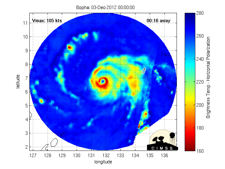
I wouldn't use a microwave loop to gauge intensity as I mainly use that for structure changes, eye changes, and intensity of the bands. It did look like it re-intensified near the coast but as the eye was coming onshore it really degraded. I agree with the 2nd part of that first sentence but then you go back in time and say how intense it was just before landfall. I don't doubt too much this was a category 5 hours before LF but during is where I disagree. Usually I'm the bullish or generous one when it comes to intensity but I just can't see it here.
CrazyC83 wrote:This could be THE biggest weather event, globally, of 2012. We haven't even heard from any of the communities that got the northern eyewall.
I have to disagree on this as well. It's going on my Top 10 list for most incredible or worst natural disasters worldwide for 2012 for sure however.
euro6208 wrote:truly unbelievable....may god bless the philippines! i won't be surprised if the death toll exceeds one thousand...
Neither would I. Usually its not the super typhoons that cause the highest death tolls (I still don't get why) but the weak storms...this could be the exception.
0 likes
-
mrbagyo

- Category 5
- Posts: 3614
- Age: 31
- Joined: Thu Apr 12, 2012 9:18 am
- Location: 14.13N 120.98E
- Contact:
Re: WPAC: BOPHA - Typhoon
I wonder what happened to Boston, Davao oriental, that town sits in the funnel of the Cateel bay, and its also in the RFQ. how high is the max surge???? Any pictures??
0 likes
The posts in this forum are NOT official forecast and should not be used as such. They are just the opinion of the poster and may or may not be backed by sound meteorological data. They are NOT endorsed by any professional institution or storm2k.org. For official information, please refer to RSMC, NHC and NWS products.
Re: WPAC: BOPHA - Typhoon
RobWESTPACWX wrote:Just typed up an article on the latest information. I am going to attempt to add more information to it. But any suggestions any of you may have please do share.
http://www.westernpacificweather.com/20 ... -hundreds/
I noticed in the Dec. 5 rpweather update on YouTube the rainfall pattern - very heavy up around Cagayan. Can you post some more of that info. here, too?
0 likes
"Normal" is Chicago under a mile of ice.
Re: WPAC: BOPHA - Typhoon
mrbagyo wrote:I wonder what happened to Boston, Davao oriental, that town sits in the funnel of the Cateel bay, and its also in the RFQ. how high is the max surge???? Any pictures??
I found this story / link...
0 likes
"Normal" is Chicago under a mile of ice.
-
dhoeze
- Tropical Storm

- Posts: 130
- Age: 42
- Joined: Tue Oct 27, 2009 2:32 am
- Location: Manila, Philippines
any update gurus on the forecasted track? saw a bit of a movement toward northeast...
will the northeast monsoon (cold and dry)enough to completely destry this system?
[img]
Uploaded with ImageShack.us[/img]
*got the image from typhoon2000
will the northeast monsoon (cold and dry)enough to completely destry this system?
[img]

Uploaded with ImageShack.us[/img]
*got the image from typhoon2000
0 likes
"Productivity is never an accident. It is always the result of a commitment to excellence, intelligent planning, and focused effort."
-
phwxenthusiast
- Category 2

- Posts: 637
- Joined: Wed Mar 24, 2010 3:10 am
- Location: Holbrook, NY (Long Island)

Who is online
Users browsing this forum: No registered users and 114 guests