WPAC: Wukong - Remnants

Moderator: S2k Moderators

Message
Author
User avatar
mrbagyo
Category 5
Category 5
Posts: 3614
Age: 31
Joined: Thu Apr 12, 2012 9:18 am
Location: 14.13N 120.98E
Contact:

Re: WPAC: INVEST 93W

#41 Postby mrbagyo » Thu Dec 20, 2012 10:53 am

Image

it really needs convection.
supercane4867 wrote:
mrbagyo wrote: my wild guess... slight El NINO.
remember joan and ivan in northern hemisphere &
cyclone susan and ron in southern hemisphere
all are cat five
I won't be surprised if Evan will have a twin...

There's obviously no El-nino, ENSO has been neutral and slightly negative in the past weeks

what i mean slight is borderline none to very weak El NINO. still the SST's are above normal in the tropical pacific.
I'm also wondering what preturbs systems like this and bopha at such low latitude... i'm not familiar with rossby or cckw.
after all, it's just a guess.. :lol:
Image
lots of rain coming in areas already devastated by bopha...
Last edited by mrbagyo on Thu Dec 20, 2012 11:06 am, edited 1 time in total.
0 likes   
The posts in this forum are NOT official forecast and should not be used as such. They are just the opinion of the poster and may or may not be backed by sound meteorological data. They are NOT endorsed by any professional institution or storm2k.org. For official information, please refer to RSMC, NHC and NWS products.

User avatar
euro6208
Category 5
Category 5
Posts: 18547
Joined: Mon Mar 08, 2004 7:50 pm
Location: Guam

Re: WPAC: INVEST 93W

#42 Postby euro6208 » Thu Dec 20, 2012 11:04 am

Image
0 likes   
Remember, all of my post aren't official. For official warnings and discussions, Please refer to your local NWS products...

NWS for the Western Pacific

https://www.weather.gov/gum/

supercane4867
Category 5
Category 5
Posts: 4966
Joined: Wed Nov 14, 2012 10:43 am

Re: WPAC: INVEST 93W

#43 Postby supercane4867 » Thu Dec 20, 2012 1:11 pm

Very messy windfield, where is the LLC?

Image
0 likes   

stormstrike
Tropical Storm
Tropical Storm
Posts: 159
Joined: Thu Nov 29, 2012 12:37 am

Re: WPAC: INVEST 93W

#44 Postby stormstrike » Thu Dec 20, 2012 4:39 pm

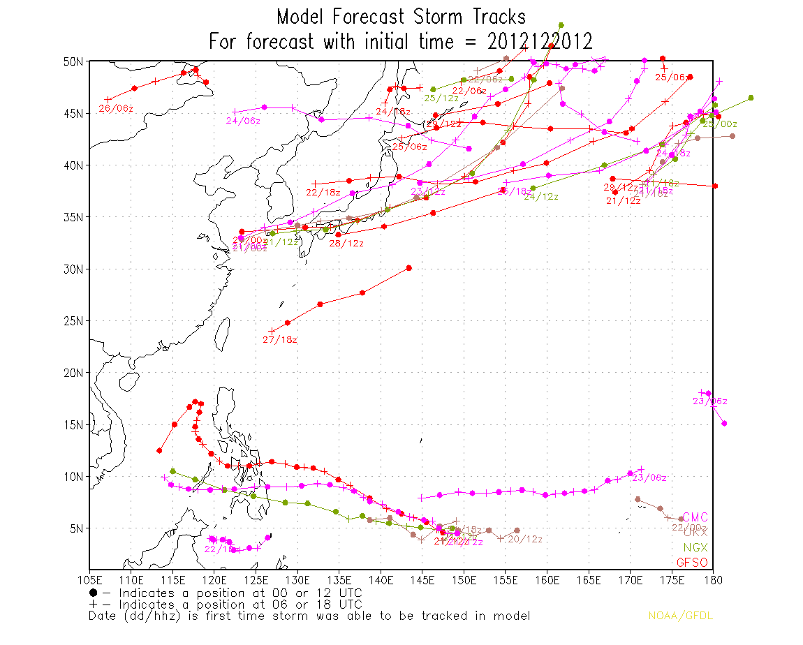
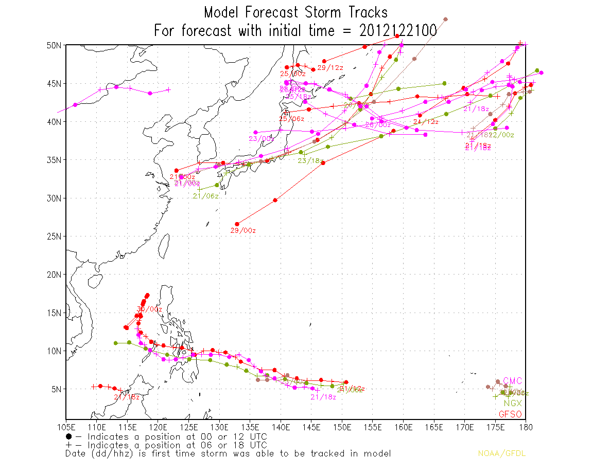
still, models are in tight agreement with the development of a system including Euro...

Image

Euro model indicating a system on Christmas Day...

Image

i wonder if this will push through...because right now it definitely looks disorganized and shear is still quite high.. :double:
0 likes   

User avatar
xtyphooncyclonex
Category 5
Category 5
Posts: 3688
Age: 22
Joined: Sat Dec 08, 2012 9:07 am
Location: Cebu City
Contact:

Re: WPAC: INVEST 93W

#45 Postby xtyphooncyclonex » Thu Dec 20, 2012 7:58 pm

I think it will be weak... Though another burst of convection came...

Image
0 likes   
REMINDER: My opinions that I, or any other NON Pro-Met in this forum, are unofficial. Please do not take my opinions as an official forecast and warning. I am NOT a meteorologist. Following my forecasts blindly may lead to false alarm, danger and risk if official forecasts from agencies are ignored.

supercane4867
Category 5
Category 5
Posts: 4966
Joined: Wed Nov 14, 2012 10:43 am

Re: WPAC: INVEST 93W

#46 Postby supercane4867 » Thu Dec 20, 2012 8:04 pm

If there's any chance of significant development it will occur in the S.China Sea :lol:

Image
Image
Image
0 likes   

dexterlabio
Category 5
Category 5
Posts: 3406
Joined: Sat Oct 24, 2009 11:50 pm

Re: WPAC: INVEST 93W

#47 Postby dexterlabio » Thu Dec 20, 2012 8:50 pm

not sure if this even has a chance of bombing out in the SCS. at this time of the year, conditions in that area is not perfect to support TC development...mainly because of the cold and dry northeast monsoon, and and I'm not also sure if SST in the SCS is pretty warm to allow storms to intensify.


IMO this could be a TD or a TS when it nears Visayas. Even it won't be a really really strong storm, both GFS and Euro are indicating a very broad area of convection associated with its circulation. So I must say a huge rainmaker for the whole country this Christmas.
0 likes   
Personal Forecast Disclaimer:
The posts in this forum are NOT official forecast and should not be used as such. They are just the opinion of the poster and may or may not be backed by sound meteorological data. They are NOT endorsed by any professional institution or storm2k.org. For official information, please refer to the NHC and NWS products.

User avatar
euro6208
Category 5
Category 5
Posts: 18547
Joined: Mon Mar 08, 2004 7:50 pm
Location: Guam

Re: WPAC: INVEST 93W

#48 Postby euro6208 » Thu Dec 20, 2012 9:18 pm

Guam enjoys yet another year without a direct tropical cyclone hit...
0 likes   
Remember, all of my post aren't official. For official warnings and discussions, Please refer to your local NWS products...

NWS for the Western Pacific

https://www.weather.gov/gum/

User avatar
euro6208
Category 5
Category 5
Posts: 18547
Joined: Mon Mar 08, 2004 7:50 pm
Location: Guam

Re: WPAC: INVEST 93W

#49 Postby euro6208 » Thu Dec 20, 2012 9:36 pm

dexterlabio wrote:not sure if this even has a chance of bombing out in the SCS. at this time of the year, conditions in that area is not perfect to support TC development...mainly because of the cold and dry northeast monsoon, and and I'm not also sure if SST in the SCS is pretty warm to allow storms to intensify.


IMO this could be a TD or a TS when it nears Visayas. Even it won't be a really really strong storm, both GFS and Euro are indicating a very broad area of convection associated with its circulation. So I must say a huge rainmaker for the whole country this Christmas.


Image

Image

the south china sea is about as warm as any area of the wpac...if not even warmer...
0 likes   
Remember, all of my post aren't official. For official warnings and discussions, Please refer to your local NWS products...

NWS for the Western Pacific

https://www.weather.gov/gum/

dexterlabio
Category 5
Category 5
Posts: 3406
Joined: Sat Oct 24, 2009 11:50 pm

Re: WPAC: INVEST 93W

#50 Postby dexterlabio » Thu Dec 20, 2012 9:58 pm

^pretty warm indeed. won't be surprised if this will pull off a Bopha once in the SCS, but it may also end up with the same fate...dying out to sea because of the cold surge.
0 likes   
Personal Forecast Disclaimer:
The posts in this forum are NOT official forecast and should not be used as such. They are just the opinion of the poster and may or may not be backed by sound meteorological data. They are NOT endorsed by any professional institution or storm2k.org. For official information, please refer to the NHC and NWS products.

stormstrike
Tropical Storm
Tropical Storm
Posts: 159
Joined: Thu Nov 29, 2012 12:37 am

Re: WPAC: INVEST 93W

#51 Postby stormstrike » Fri Dec 21, 2012 3:03 am

Latest model run..

Image
0 likes   

User avatar
xtyphooncyclonex
Category 5
Category 5
Posts: 3688
Age: 22
Joined: Sat Dec 08, 2012 9:07 am
Location: Cebu City
Contact:

Re: WPAC: INVEST 93W

#52 Postby xtyphooncyclonex » Fri Dec 21, 2012 5:08 am

Way more Organized...

Image

High chance of development in the next 3-5 days... Hope that it'll not be that strong...
0 likes   
REMINDER: My opinions that I, or any other NON Pro-Met in this forum, are unofficial. Please do not take my opinions as an official forecast and warning. I am NOT a meteorologist. Following my forecasts blindly may lead to false alarm, danger and risk if official forecasts from agencies are ignored.

User avatar
xtyphooncyclonex
Category 5
Category 5
Posts: 3688
Age: 22
Joined: Sat Dec 08, 2012 9:07 am
Location: Cebu City
Contact:

Re: WPAC: INVEST 93W

#53 Postby xtyphooncyclonex » Fri Dec 21, 2012 5:13 am

GFS on December 25, 18 UTC

Image

Wet Christmas for the Visayas, Southern Luzon and parts of Mindanao...
0 likes   
REMINDER: My opinions that I, or any other NON Pro-Met in this forum, are unofficial. Please do not take my opinions as an official forecast and warning. I am NOT a meteorologist. Following my forecasts blindly may lead to false alarm, danger and risk if official forecasts from agencies are ignored.

User avatar
xtyphooncyclonex
Category 5
Category 5
Posts: 3688
Age: 22
Joined: Sat Dec 08, 2012 9:07 am
Location: Cebu City
Contact:

Re: WPAC: INVEST 93W

#54 Postby xtyphooncyclonex » Fri Dec 21, 2012 6:14 am

PAGASA says it won't become a cyclone... (News/Media believes what PAGASA says)
0 likes   
REMINDER: My opinions that I, or any other NON Pro-Met in this forum, are unofficial. Please do not take my opinions as an official forecast and warning. I am NOT a meteorologist. Following my forecasts blindly may lead to false alarm, danger and risk if official forecasts from agencies are ignored.

stormstrike
Tropical Storm
Tropical Storm
Posts: 159
Joined: Thu Nov 29, 2012 12:37 am

Re: WPAC: INVEST 93W

#55 Postby stormstrike » Fri Dec 21, 2012 7:54 am

xtyphooncyclonex wrote:Way more Organized...

Image

High chance of development in the next 3-5 days... Hope that it'll not be that strong...


it's still sheared as of the moment..... convection is somehow detached from the center....windshear is quite high on its SE quadrant..
0 likes   

User avatar
xtyphooncyclonex
Category 5
Category 5
Posts: 3688
Age: 22
Joined: Sat Dec 08, 2012 9:07 am
Location: Cebu City
Contact:

Re: WPAC: INVEST 93W

#56 Postby xtyphooncyclonex » Fri Dec 21, 2012 9:00 am

stormstrike wrote:
xtyphooncyclonex wrote:Way more Organized...

Image

High chance of development in the next 3-5 days... Hope that it'll not be that strong...


it's still sheared as of the moment..... convection is somehow detached from the center....windshear is quite high on its SE quadrant..


The disturbance has a weird center...
0 likes   
REMINDER: My opinions that I, or any other NON Pro-Met in this forum, are unofficial. Please do not take my opinions as an official forecast and warning. I am NOT a meteorologist. Following my forecasts blindly may lead to false alarm, danger and risk if official forecasts from agencies are ignored.

supercane4867
Category 5
Category 5
Posts: 4966
Joined: Wed Nov 14, 2012 10:43 am

Re: WPAC: INVEST 93W

#57 Postby supercane4867 » Fri Dec 21, 2012 9:02 am

Center relocated
6.3N-146.5E

Image
0 likes   

Meow

Re: WPAC: INVEST 93W

#58 Postby Meow » Fri Dec 21, 2012 10:36 am

xtyphooncyclonex wrote:PAGASA says it won't become a cyclone... (News/Media believes what PAGASA says)

Tropical cyclones seldom follow what the PAGASA estimates.
0 likes   

User avatar
euro6208
Category 5
Category 5
Posts: 18547
Joined: Mon Mar 08, 2004 7:50 pm
Location: Guam

Re: WPAC: INVEST 93W

#59 Postby euro6208 » Fri Dec 21, 2012 10:51 am

THE AREA OF CONVECTION PREVIOUSLY LOCATED NEAR 5.3N 156.6E
IS NOW LOCATED NEAR 5.4N 152.7E, APPROXIMATELY 135 NM SOUTH-
SOUTHEAST OF CHUUK. ANIMATED MULTISPECTRAL SATELLITE IMAGERY DEPICTS
A POORLY-DEFINED LOW-LEVEL CIRCULATION CENTER (LLCC) WITH
DISORGANIZED DEEP CONVECTION FLARING OVER THE WESTERN QUADRANT OF
THE LLCC. A 210346Z AMSU-B IMAGE SHOWS A BROAD LLCC WITH SHALLOW
CONVECTIVE BANDING. A 201934Z WINDSAT PARTIAL IMAGE SHOWS AN
ELONGATED CIRCULATION WITH ONLY 10 TO 15 KNOT WINDS, POSITIONED
ALONG THE SOUTHEAST EDGE OF A 20 TO 25 KNOT NORTHEASTERLY SURGE.
SURFACE OBSERVATIONS FROM CHUUK SHOW SUSTAINED NORTHEASTERLY WINDS
OF 10 TO 15 KNOTS GUSTING TO 20 TO 30 KNOTS AND SLP VALUES NEAR
1004MB WITH ABOUT A 2-MB 24-HOUR SLP DECREASE. UPPER-LEVEL ANALYSIS
CONTINUES TO INDICATE A MARGINAL ENVIRONMENT WITH DIFFLUENT,
EASTERLY FLOW AND WEAK TO MODERATE (10 TO 20 KNOTS) VERTICAL WIND
SHEAR. MAXIMUM SUSTAINED SURFACE WINDS ARE ESTIMATED AT 10 TO 15
KNOTS. MINIMUM SEA LEVEL PRESSURE IS ESTIMATED TO BE NEAR 1004 MB.
BASED ON THE MARGINAL ENVIRONMENT AND LACK OF CONVECTIVE
ORGANIZATION, THE POTENTIAL FOR THE DEVELOPMENT OF A SIGNIFICANT
TROPICAL CYCLONE WITHIN THE NEXT 24 HOURS REMAINS LOW.
0 likes   
Remember, all of my post aren't official. For official warnings and discussions, Please refer to your local NWS products...

NWS for the Western Pacific

https://www.weather.gov/gum/

supercane4867
Category 5
Category 5
Posts: 4966
Joined: Wed Nov 14, 2012 10:43 am

Re: WPAC: INVEST 93W

#60 Postby supercane4867 » Fri Dec 21, 2012 9:47 pm

LOL

Image
0 likes   


Return to “2012”

Who is online

Users browsing this forum: No registered users and 45 guests