ATL: Ex-NINE - Models
Moderator: S2k Moderators
-
Dean4Storms
- S2K Supporter

- Posts: 6356
- Age: 61
- Joined: Sun Aug 31, 2003 1:01 pm
- Location: Miramar Bch. FL
-
Dean4Storms
- S2K Supporter
- Posts: 6356
- Age: 61
- Joined: Sun Aug 31, 2003 1:01 pm
- Location: Miramar Bch. FL
-
jlauderdal
- S2K Supporter
- Posts: 6809
- Joined: Wed May 19, 2004 5:46 am
- Location: NE Fort Lauderdale
- Contact:
Re: ATL: INVEST 93L - Models
Dean4Storms wrote:The 00z China CMA Global Model has a 92kt Hurricane into Panama City Bch. to Destin area come next Tuesday!
yep, its going to smash through that frontal system
0 likes

Re: ATL: INVEST 93L - Discussion
0 likes
-
stormlover2013
- Category 5

- Posts: 2312
- Joined: Thu Aug 22, 2013 12:06 pm
- Location: Lumberton, Texas
Re: ATL: INVEST 93L - Discussion
spiral wrote:http://i60.tinypic.com/14tmotf.jpg
what's left over and merges with the front is by no means a hurricane on the EC.
Low resolution Euro map is useless.
Last edited by NDG on Tue Oct 21, 2014 7:31 am, edited 1 time in total.
0 likes

Re: ATL: INVEST 93L - Models
Looking at the 850 vorticity, the 00z Euro takes the BOC system and stretches it out after making landfall with the Yucatan and splits the energy but leaves the low level voriticity to spin back up in the NW Carribean. For all the GFS has been bad this year, it has been leading the charge in showing this scenario. I would not discount the leftover NW carribean scenario just yet.
Leftover energy that stays in the NW Carribean:

Leftover energy that stays in the NW Carribean:
0 likes
The following post is NOT an official forecast and should not be used as such. It is just the opinion of the poster and may or may not be backed by sound meteorological data. It is NOT endorsed by any professional institution including storm2k.org For Official Information please refer to the NHC and NWS products.
-
tolakram
- Admin

- Posts: 19182
- Age: 60
- Joined: Sun Aug 27, 2006 8:23 pm
- Location: Florence, KY (name is Mark)
Re: ATL: INVEST 93L - Models
If you look at the Euro vorticity loop
http://moe.met.fsu.edu/cgi-bin/ecmwf-opertc2.cgi?time=2014102100&field=850mb+Vorticity&hour=Animation
It looks to me the storm the Euro finally develops near the end of the run is directly related to 93L, as suggested by blp. I guess 93L could be with us for a while here.
http://moe.met.fsu.edu/cgi-bin/ecmwf-opertc2.cgi?time=2014102100&field=850mb+Vorticity&hour=Animation
It looks to me the storm the Euro finally develops near the end of the run is directly related to 93L, as suggested by blp. I guess 93L could be with us for a while here.
0 likes
M a r k
- - - - -
Join us in chat: Storm2K Chatroom Invite. Android and IOS apps also available.
The posts in this forum are NOT official forecasts and should not be used as such. Posts are NOT endorsed by any professional institution or STORM2K.org. For official information and forecasts, please refer to NHC and NWS products.

Re: ATL: INVEST 93L - Models
Yeah the situation has always been with the global models that a piece of energy will be left behind in the western Caribbean under rather weak steering currents. What we are really speculating is what's the ultimate strength and track of the leftover energy. I think the models haven't quite figured out what's gonna happen after 5 days - which is pretty typical.
0 likes
-
gatorcane

- S2K Supporter
- Posts: 23499
- Age: 46
- Joined: Sun Mar 13, 2005 3:54 pm
- Location: Boca Raton, FL
spiral wrote:http://i60.tinypic.com/14tmotf.jpg
what's left over and merges with the front is by no means a hurricane on the EC.
Spiral you are right - no hurricane but like others have pointed out the ECMWF has a similar solution now to the GFS with carrying the low-level vort from 93L into the NW Caribbean but it doesn't show it developing much beyond maybe a depression (at least on this run). Best to use the PENN state site for looking at the details:

Oh and the GFS has not backed down from the NW Caribbean hurricane possibility 06Z GFS below with a 985MB cane moving slowly north. Showed the same thing on the 00Z GFS run too and the past several runs before that actually.

Last edited by gatorcane on Tue Oct 21, 2014 8:04 am, edited 2 times in total.
0 likes
-
tropicwatch

- Category 5
- Posts: 3205
- Age: 60
- Joined: Sat Jun 02, 2007 10:01 am
- Location: Panama City Florida
- Contact:
What a mess!
0 likes
Tropicwatch
Agnes 72', Eloise 75, Elena 85', Kate 85', Charley 86', Florence 88', Beryl 94', Dean 95', Erin 95', Opal 95', Earl 98', Georges 98', Ivan 2004', Arlene 2005', Dennis 2005', Ida 2009' Debby 2012' Irma 2017' Michael 2018'
Agnes 72', Eloise 75, Elena 85', Kate 85', Charley 86', Florence 88', Beryl 94', Dean 95', Erin 95', Opal 95', Earl 98', Georges 98', Ivan 2004', Arlene 2005', Dennis 2005', Ida 2009' Debby 2012' Irma 2017' Michael 2018'

-
gatorcane
- S2K Supporter
- Posts: 23499
- Age: 46
- Joined: Sun Mar 13, 2005 3:54 pm
- Location: Boca Raton, FL
Re: ATL: INVEST 93L - Models
stormlover2013 wrote:Lol cmc model is the astros of baseball lol horrible
00Z CMC 168 hours below:

0 likes
-
SFLcane

- S2K Supporter
- Posts: 9626
- Age: 46
- Joined: Sat Jun 05, 2010 1:44 pm
- Location: Lake Worth Florida
Re: ATL: INVEST 93L - Models
Some models even taking this back into the e-pac. I still dont buy any strengthening Storm in the carribbean. GFS has been horrific
0 likes
-
Hurricaneman

- Category 5
- Posts: 7284
- Age: 43
- Joined: Tue Aug 31, 2004 3:24 pm
- Location: central florida
The models are indicating that the path and intensity are going to be unpredictable once in the Western Caribbean so what I believe is all options are on the table even dissipation
The posts in this forum are NOT official forecast and should not be used as such. They are just the opinion of the poster and may or may not be backed by sound meteorological data. They are NOT endorsed by any professional institution or storm2k.org. For official information, please refer to the NHC and NWS products
The posts in this forum are NOT official forecast and should not be used as such. They are just the opinion of the poster and may or may not be backed by sound meteorological data. They are NOT endorsed by any professional institution or storm2k.org. For official information, please refer to the NHC and NWS products
0 likes
-
Blown Away

- S2K Supporter
- Posts: 9874
- Joined: Wed May 26, 2004 6:17 am
Re: ATL: INVEST 93L - Models

NCEP has 93L sitting in NW Caribbean in 7 days... Generally moves it slowly ENE across the Yucatan to the 7 day point...

TAFB says "Possible Tropical Cyclone" on East coast of Yucatan in 72 hours...
0 likes
Hurricane Eye Experience: David 79, Irene 99, Frances 04, Jeanne 04, Wilma 05... EYE COMING MY WAY IN 2024…
Hurricane Brush Experience: Andrew 92, Erin 95, Floyd 99, Matthew 16, Irma 17, Ian 22, Nicole 22…
Hurricane Brush Experience: Andrew 92, Erin 95, Floyd 99, Matthew 16, Irma 17, Ian 22, Nicole 22…
-
Blown Away
- S2K Supporter
- Posts: 9874
- Joined: Wed May 26, 2004 6:17 am
Re: ATL: INVEST 93L - Models

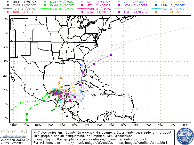
12z TVCN now ends over NW Caribbean... TVCN consensus is usually where the NHC would follow...

12z Models...

12z Intensity... A few more models now showing moderate TS...
0 likes
Hurricane Eye Experience: David 79, Irene 99, Frances 04, Jeanne 04, Wilma 05... EYE COMING MY WAY IN 2024…
Hurricane Brush Experience: Andrew 92, Erin 95, Floyd 99, Matthew 16, Irma 17, Ian 22, Nicole 22…
Hurricane Brush Experience: Andrew 92, Erin 95, Floyd 99, Matthew 16, Irma 17, Ian 22, Nicole 22…
-
floridasun78
- Category 5
- Posts: 3755
- Joined: Sun May 17, 2009 10:16 pm
- Location: miami fl
Re: ATL: INVEST 93L - Models
Blown Away wrote: 12z Intensity... A few more models now showing moderate TS...
none show as hurr in 12z Intensity.
0 likes
-
AdamFirst

- S2K Supporter
- Posts: 2488
- Age: 35
- Joined: Thu Aug 14, 2008 10:54 am
- Location: Port Saint Lucie, FL
Re: ATL: INVEST 93L - Models
12z GFS is rolling
Through 96 hours, same story. Bulk of energy pulled up into the front with a developing area in the NW Caribbean.
Through 96 hours, same story. Bulk of energy pulled up into the front with a developing area in the NW Caribbean.
0 likes
Dolphins Marlins Canes Golden Panthers HEAT
Andrew 1992 - Irene 1999 - Frances 2004 - Jeanne 2004 - Wilma 2005 - Fay 2008 - Isaac 2012 - Matthew 2016 - Irma 2017 - Dorian 2019 - Ian 2022 - Nicole 2022
Andrew 1992 - Irene 1999 - Frances 2004 - Jeanne 2004 - Wilma 2005 - Fay 2008 - Isaac 2012 - Matthew 2016 - Irma 2017 - Dorian 2019 - Ian 2022 - Nicole 2022
-
Blown Away
- S2K Supporter
- Posts: 9874
- Joined: Wed May 26, 2004 6:17 am
Re: ATL: INVEST 93L - Models
floridasun78 wrote:Blown Away wrote: 12z Intensity... A few more models now showing moderate TS...
none show as hurr in 12z Intensity.
True, but compared to previous intensity forecasts there are more models showing TS than before... Just a trend to follow...
0 likes
Hurricane Eye Experience: David 79, Irene 99, Frances 04, Jeanne 04, Wilma 05... EYE COMING MY WAY IN 2024…
Hurricane Brush Experience: Andrew 92, Erin 95, Floyd 99, Matthew 16, Irma 17, Ian 22, Nicole 22…
Hurricane Brush Experience: Andrew 92, Erin 95, Floyd 99, Matthew 16, Irma 17, Ian 22, Nicole 22…
Who is online
Users browsing this forum: No registered users and 5 guests