EPAC: CRISTINA - Post-Tropical
Moderator: S2k Moderators
-
hurricanes1234
- Category 5

- Posts: 2904
- Joined: Sat Jul 28, 2012 6:19 pm
- Location: Trinidad and Tobago
Yellow Evan's higher estimate was right! If this continues like this, I think we could see 3E before Monday.
0 likes
PLEASE NOTE: With the exception of information from weather agencies that I may copy and paste here, my posts will NEVER be official, since I am NOT a meteorologist. They are solely my amateur opinion, and may or may not be accurate. Therefore, please DO NOT use them as official details, particularly when making important decisions. Thank you.

Re: EPAC: INVEST 94E
Very impressed

0 likes
The above post and any post by Ntxw is NOT an official forecast and should not be used as such. It is just the opinion of the poster and may or may not be backed by sound meteorological data. It is NOT endorsed by any professional institution including Storm2k. For official information, please refer to NWS products.
Help support Storm2K!

-
Yellow Evan

- Professional-Met

- Posts: 15959
- Age: 25
- Joined: Fri Jul 15, 2011 12:48 pm
- Location: Henderson, Nevada/Honolulu, HI
- Contact:
-
cycloneye

- Admin

- Posts: 139525
- Age: 67
- Joined: Thu Oct 10, 2002 10:54 am
- Location: San Juan, Puerto Rico
Re: EPAC: INVEST 94E
EP, 94, 2014060800, , BEST, 0, 134N, 1006W, 25, 1007, LO
0 likes
Visit the Caribbean-Central America Weather Thread where you can find at first post web cams,radars
and observations from Caribbean basin members Click Here
and observations from Caribbean basin members Click Here
-
cycloneye
- Admin
- Posts: 139525
- Age: 67
- Joined: Thu Oct 10, 2002 10:54 am
- Location: San Juan, Puerto Rico
Re: EPAC: INVEST 94E
CHGE77
TROPICAL CYCLONE GUIDANCE MESSAGE
NWS NATIONAL HURRICANE CENTER MIAMI FL
0044 UTC SUN JUN 8 2014
DISCLAIMER...NUMERICAL MODELS ARE SUBJECT TO LARGE ERRORS.
PLEASE REFER TO NHC OFFICIAL FORECASTS FOR TROPICAL CYCLONE
AND SUBTROPICAL CYCLONE INFORMATION.
EAST PACIFIC OBJECTIVE AIDS FOR
DISTURBANCE INVEST (EP942014) 20140608 0000 UTC
...00 HRS... ...12 HRS... ...24 HRS... ...36 HRS...
140608 0000 140608 1200 140609 0000 140609 1200
LAT LON LAT LON LAT LON LAT LON
BAMS 13.3N 100.6W 14.2N 100.5W 14.9N 100.6W 15.4N 100.8W
BAMD 13.3N 100.6W 13.8N 101.5W 14.2N 102.3W 14.5N 103.1W
BAMM 13.3N 100.6W 14.0N 101.1W 14.5N 101.6W 14.8N 102.2W
LBAR 13.3N 100.6W 13.9N 101.3W 14.7N 102.1W 15.7N 102.9W
SHIP 25KTS 34KTS 44KTS 53KTS
DSHP 25KTS 34KTS 44KTS 53KTS
...48 HRS... ...72 HRS... ...96 HRS... ..120 HRS...
140610 0000 140611 0000 140612 0000 140613 0000
LAT LON LAT LON LAT LON LAT LON
BAMS 15.9N 101.3W 16.5N 103.2W 17.1N 106.0W 17.4N 109.8W
BAMD 14.8N 104.0W 15.2N 106.3W 15.9N 109.1W 16.8N 112.1W
BAMM 15.1N 102.8W 15.2N 104.9W 15.6N 107.7W 16.0N 110.9W
LBAR 16.6N 103.7W 19.4N 104.6W 22.4N 104.2W 24.1N 102.8W
SHIP 62KTS 75KTS 81KTS 85KTS
DSHP 62KTS 75KTS 81KTS 85KTS
...INITIAL CONDITIONS...
LATCUR = 13.3N LONCUR = 100.6W DIRCUR = 320DEG SPDCUR = 5KT
LATM12 = 12.5N LONM12 = 99.9W DIRM12 = 320DEG SPDM12 = 5KT
LATM24 = 11.9N LONM24 = 99.3W
WNDCUR = 25KT RMAXWD = 75NM WNDM12 = 20KT
CENPRS = 1007MB OUTPRS = 1010MB OUTRAD = 240NM SDEPTH = S
RD34NE = 0NM RD34SE = 0NM RD34SW = 0NM RD34NW = 0NM
0 likes
Visit the Caribbean-Central America Weather Thread where you can find at first post web cams,radars
and observations from Caribbean basin members Click Here
and observations from Caribbean basin members Click Here
-
Yellow Evan
- Professional-Met
- Posts: 15959
- Age: 25
- Joined: Fri Jul 15, 2011 12:48 pm
- Location: Henderson, Nevada/Honolulu, HI
- Contact:
A broad low pressure system located several hundred miles south of
Acapulco, Mexico, is producing a large area of cloudiness and
disorganized showers. Environmental conditions are currently only
marginally favorable, but they are expected to be become more
conducive for development to occur during the next several days as
the low moves northwestward at 5 to 10 mph.
* Formation chance through 48 hours...medium...40 percent.
* Formation chance through 5 days...high...80 percent.
0 likes
-
Yellow Evan
- Professional-Met
- Posts: 15959
- Age: 25
- Joined: Fri Jul 15, 2011 12:48 pm
- Location: Henderson, Nevada/Honolulu, HI
- Contact:
-
supercane4867
- Category 5
- Posts: 4966
- Joined: Wed Nov 14, 2012 10:43 am
-
cycloneye
- Admin
- Posts: 139525
- Age: 67
- Joined: Thu Oct 10, 2002 10:54 am
- Location: San Juan, Puerto Rico
Re: EPAC: INVEST 94E
I think the chance to go up to hurricane were great yesterday but are going down fast today as it has moved up in latitude more faster than expected because of land being more closer as well the dry air and less warmer ssts. If this had stayed around 11N-12N all the way,then it would bloosom bigtime into a strong hurricane.
0 likes
Visit the Caribbean-Central America Weather Thread where you can find at first post web cams,radars
and observations from Caribbean basin members Click Here
and observations from Caribbean basin members Click Here
-
hurricanes1234
- Category 5
- Posts: 2904
- Joined: Sat Jul 28, 2012 6:19 pm
- Location: Trinidad and Tobago
Based on those model forecasts, I wouldn't rule out the possibility that this remains an invest and dies from there. I guess we will have to wait on MJO before we see a hurricane.
0 likes
PLEASE NOTE: With the exception of information from weather agencies that I may copy and paste here, my posts will NEVER be official, since I am NOT a meteorologist. They are solely my amateur opinion, and may or may not be accurate. Therefore, please DO NOT use them as official details, particularly when making important decisions. Thank you.
-
cycloneye
- Admin
- Posts: 139525
- Age: 67
- Joined: Thu Oct 10, 2002 10:54 am
- Location: San Juan, Puerto Rico
Re: EPAC: INVEST 94E
TROPICAL WEATHER OUTLOOK
NWS NATIONAL HURRICANE CENTER MIAMI FL
500 AM PDT SUN JUN 8 2014
For the eastern North Pacific...east of 140 degrees west longitude:
A broad low pressure area located a couple hundred miles south-
southwest of Acapulco, Mexico, is producing a large area of
disorganized showers and thunderstorms. Environmental conditions
are conducive for gradual development, and a tropical depression
will likely form during the next few days while the low moves
northwestward at 5 to 10 mph.
* Formation chance through 48 hours...medium...40 percent.
* Formation chance through 5 days...high...80 percent.
$$
Forecaster Blake
0 likes
Visit the Caribbean-Central America Weather Thread where you can find at first post web cams,radars
and observations from Caribbean basin members Click Here
and observations from Caribbean basin members Click Here


-
Yellow Evan
- Professional-Met
- Posts: 15959
- Age: 25
- Joined: Fri Jul 15, 2011 12:48 pm
- Location: Henderson, Nevada/Honolulu, HI
- Contact:
GFS shows a weak TS, but hey, at least the CMC shows a borderline hurricane out of this now. This probably should form; shear looks okay, SST's are fairly warm, and dry air, while a little is getting ingested, does not become a major issue until we hit the subtropical jet north of 20N. I hate to say this, but ill bring up 2013. Sometimes the models have an equatorword bias (particularly the Euro), and they bust. This is what happened IMO in 2013, and the same reason why almost all the storm were weak; they were moving too quickly and due to a northern ITCZ, heading NW rather than W.
The posts in this forum are NOT official forecast and should not be used as such. They are just the opinion of the poster and may or may not be backed by sound meteorological data. They are NOT endorsed by any professional institution or storm2k.org. For official information, please refer to the NHC and NWS products.
The posts in this forum are NOT official forecast and should not be used as such. They are just the opinion of the poster and may or may not be backed by sound meteorological data. They are NOT endorsed by any professional institution or storm2k.org. For official information, please refer to the NHC and NWS products.
0 likes
-
hurricanes1234
- Category 5
- Posts: 2904
- Joined: Sat Jul 28, 2012 6:19 pm
- Location: Trinidad and Tobago
Re: EPAC: INVEST 94E
I'm not nearly as keen as yesterday on 94E developing into a hurricane. Plus, it doesn't look any better than it did last night, probably slightly worse (in my opinion). I won't be surprised to see a downgrade to 70% in 5 days, which seems a bit reasonable to me since there has been no development since then. If this develops at all, I'd only expect a high-end tropical storm from it, at most.
0 likes
PLEASE NOTE: With the exception of information from weather agencies that I may copy and paste here, my posts will NEVER be official, since I am NOT a meteorologist. They are solely my amateur opinion, and may or may not be accurate. Therefore, please DO NOT use them as official details, particularly when making important decisions. Thank you.
-
Yellow Evan
- Professional-Met
- Posts: 15959
- Age: 25
- Joined: Fri Jul 15, 2011 12:48 pm
- Location: Henderson, Nevada/Honolulu, HI
- Contact:
I see no reason to downgrade this. Conditions are still fairly favorable for a few days. Granted, I see no reason to raise this either. It IMO probs has plenty of time.
FTR, I don't expect most of storms to die off in unfavorable conditions, and I don't expect to see what happened in 2013 become common (Storms speeding off to the cold SST's off the coast of Baja), at least not till the late-season, if at all. Remember there is next to no troughing in July and August to carry the storm north. Also, the subtropical jet which tends to be an issue at the start of El Ninos, won't be much of a factor in the mid and to a lesser extent the late season. Thirdly, due to +PDO SST's are above average off the Baja coast. In 2013, it was an issue only in late August/September. In July and August, the main issue was near-record low vertical instability, not the fast motion/northern ITCZ. It's only June after all, we still got a long way to go.
The posts in this forum are NOT official forecast and should not be used as such. They are just the opinion of the poster and may or may not be backed by sound meteorological data. They are NOT endorsed by any professional institution or storm2k.org. For official information, please refer to the NHC and NWS products.
0 likes
-
Yellow Evan
- Professional-Met
- Posts: 15959
- Age: 25
- Joined: Fri Jul 15, 2011 12:48 pm
- Location: Henderson, Nevada/Honolulu, HI
- Contact:
A broad low pressure area located a couple hundred miles southwest
of Acapulco, Mexico, continues to produce a large area of
disorganized showers and thunderstorms. Environmental conditions
appear conducive for gradual development, and a tropical depression
will likely form during the next few days while the low moves
generally northwestward at 5 to 10 mph.
* Formation chance through 48 hours...medium...50 percent.
* Formation chance through 5 days...high...80 percent.
0 likes
-
cycloneye
- Admin
- Posts: 139525
- Age: 67
- Joined: Thu Oct 10, 2002 10:54 am
- Location: San Juan, Puerto Rico
Re: EPAC: INVEST 94E
EP, 94, 2014060818, , BEST, 0, 154N, 1024W, 25, 1007, LO
As long it continues to move NW it has no opportunity to get very strong.
As long it continues to move NW it has no opportunity to get very strong.
0 likes
Visit the Caribbean-Central America Weather Thread where you can find at first post web cams,radars
and observations from Caribbean basin members Click Here
and observations from Caribbean basin members Click Here
-
supercane4867
- Category 5
- Posts: 4966
- Joined: Wed Nov 14, 2012 10:43 am
Re: EPAC: INVEST 94E
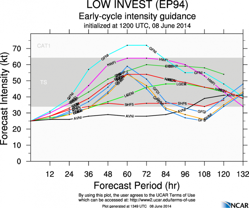
Latest HWRF is likely too bullish on intensification, also showing rapid weakening after day 4

GFDL pulls it toward the coast and dissipate due to land

GFDL pulls it toward the coast and dissipate due to land
0 likes
-
Yellow Evan
- Professional-Met
- Posts: 15959
- Age: 25
- Joined: Fri Jul 15, 2011 12:48 pm
- Location: Henderson, Nevada/Honolulu, HI
- Contact:
Re: EPAC: INVEST 94E
cycloneye wrote:EP, 94, 2014060818, , BEST, 0, 154N, 1024W, 25, 1007, LO
As long it continues to move NW it has no opportunity to get very strong.
It's located over warm waters that are above average though still.
0 likes
-
hurricanes1234
- Category 5
- Posts: 2904
- Joined: Sat Jul 28, 2012 6:19 pm
- Location: Trinidad and Tobago
Warm water may be ineffective when air is dry. I still expect little development from this and the probability of a hurricane, while not completely nil, is low, in my opinion. As cycloneye said, as long as it continues moving northwest, it's going to run into hostile conditions and diminish its chances of getting strong.
Last edited by hurricanes1234 on Sun Jun 08, 2014 3:32 pm, edited 1 time in total.
0 likes
PLEASE NOTE: With the exception of information from weather agencies that I may copy and paste here, my posts will NEVER be official, since I am NOT a meteorologist. They are solely my amateur opinion, and may or may not be accurate. Therefore, please DO NOT use them as official details, particularly when making important decisions. Thank you.
Who is online
Users browsing this forum: No registered users and 7 guests