
GFS is not indicating favorable conditions. The surface low is EAST of the UH, which means fairly strong northerly wind shear will be present over the system
a weak, sheared TS at most of the most likely outcome, though development chances do look better than not
ATL: ARTHUR - Post-Tropical - Discussion
Moderator: S2k Moderators

-
cycloneye

- Admin

- Posts: 139349
- Age: 67
- Joined: Thu Oct 10, 2002 10:54 am
- Location: San Juan, Puerto Rico
Re: ATL: INVEST 91L - Discussion
Here is Dr Jeff Masters discussion about 91L.
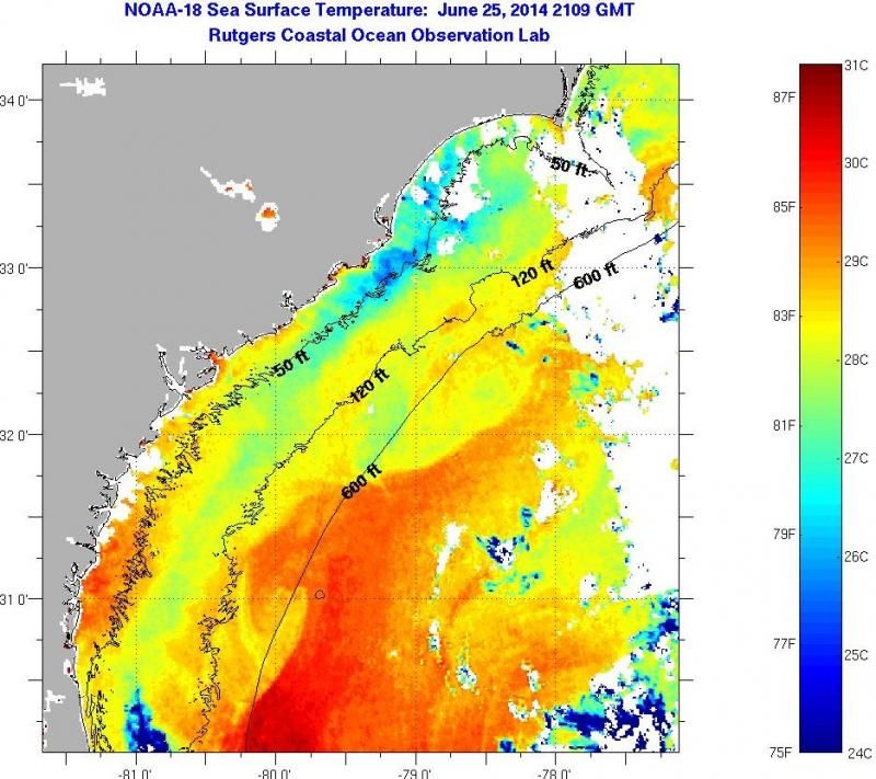
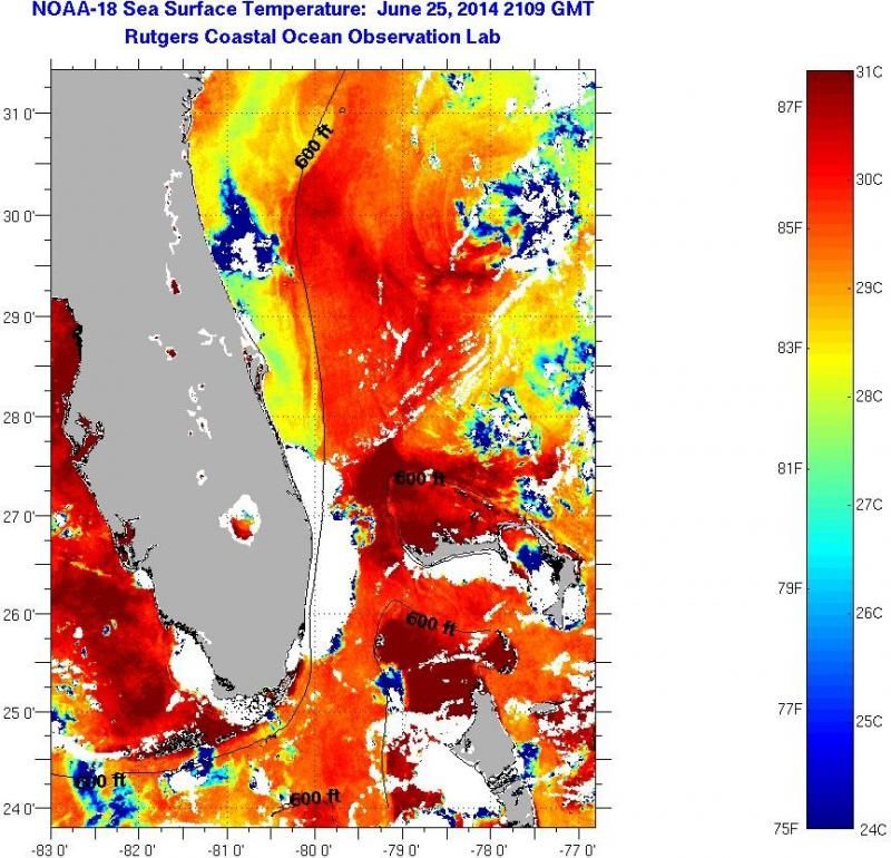
A area of disturbed weather over the warm waters of the Gulf Stream current off the Southeast U.S. coast has been designated Invest 91L by NHC. Satellite loops on Saturday morning showed 91L with only a small amount of heavy thunderstorm activity that was poorly organized. There was no hint of a surface circulation trying to form. Long-range radar out of Melbourne, Florida showed a few modest areas of rainfall over the ocean about 50 - 150 miles east of the Central Florida coast. Sea surface temperatures in this region were about 1°C above average, 27 - 28°C--plenty of heat energy for a developing tropical cyclone. Wind shear was moderate, 10 - 15 knots. The shear was due to strong upper-level winds out of the north, which were keeping any heavy thunderstorms from developing on the north side of 91L. Water vapor satellite loops showed that the atmosphere was moderately moist off the Southeast U.S. coast, and dry air should not be a significant impediment to development. The Hurricane Hunters are on call to investigate 91L on Sunday afternoon.
Forecast for 91L
The 12Z Saturday run of the SHIPS model showed light to moderate shear, 5 - 15 knots, over 91L for the next five days. With the disturbance parked over the warm waters of the Gulf Stream, organization into a tropical depression is a good possibility. In their 8 am EDT Saturday Tropical Weather Outlook, NHC gave 91L 2-day and 5-day development odds of 30% and 50%, respectively. As of noon EDT, I'd put these odds higher, at 40% and 60%, respectively. Steering currents are weak off of the Southeast U.S. coast, and the uncertainty in the track of 91L is higher than usual. The 00Z Saturday run of the UKMET and European models predicted a slow motion to the northeast, with the European model showing a potential threat to the North Carolina coast by Thursday. The 00Z and 06Z Saturday runs of the GFS model predict the opposite motion, a slow track southwestwards with a landfall in Florida on Tuesday. None of these models showed 91L reaching tropical storm strength. The UKMET and European model have been pretty consistent with their recent runs, so I favor their solution of a more northeasterly motion for 91L over the next five days.
0 likes
Visit the Caribbean-Central America Weather Thread where you can find at first post web cams,radars
and observations from Caribbean basin members Click Here
and observations from Caribbean basin members Click Here
-
SeGaBob

-
cycloneye
- Admin
- Posts: 139349
- Age: 67
- Joined: Thu Oct 10, 2002 10:54 am
- Location: San Juan, Puerto Rico
Re: ATL: INVEST 91L - Discussion
TROPICAL WEATHER OUTLOOK
NWS NATIONAL HURRICANE CENTER MIAMI FL
200 PM EDT SAT JUN 28 2014
For the North Atlantic...Caribbean Sea and the Gulf of Mexico:
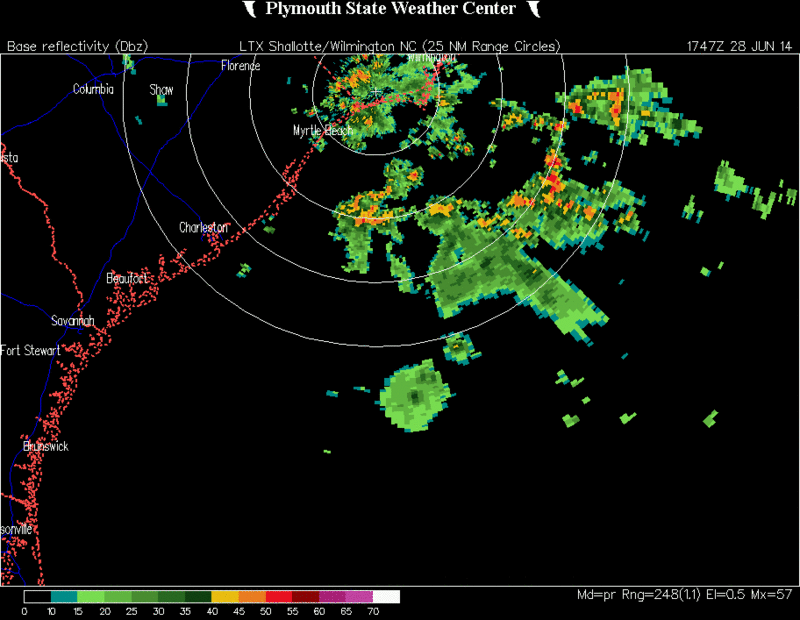
A broad low pressure area located about 120 miles southeast of the
coast of South Carolina continues to produce disorganized
showers and thunderstorms. Environmental conditions are expected
to remain conducive for gradual development of this system while
it drifts southward offshore of Georgia and northeastern Florida
during the next few days.
* Formation chance through 48 hours...medium...40 percent.
* Formation chance through 5 days...high...60 percent.
$$
Forecaster Brown
NWS NATIONAL HURRICANE CENTER MIAMI FL
200 PM EDT SAT JUN 28 2014
For the North Atlantic...Caribbean Sea and the Gulf of Mexico:
A broad low pressure area located about 120 miles southeast of the
coast of South Carolina continues to produce disorganized
showers and thunderstorms. Environmental conditions are expected
to remain conducive for gradual development of this system while
it drifts southward offshore of Georgia and northeastern Florida
during the next few days.
* Formation chance through 48 hours...medium...40 percent.
* Formation chance through 5 days...high...60 percent.
$$
Forecaster Brown
0 likes
Visit the Caribbean-Central America Weather Thread where you can find at first post web cams,radars
and observations from Caribbean basin members Click Here
and observations from Caribbean basin members Click Here
Not sure where they are getting favorable conditions from. Conditions appear as if they will be marginal at best
Not unfavorable enough to prevent development, but most certainly not favorable. We have what looks like 25 KT of shear over the center. The SHIPS area average is including the region SW of the center with little shear
Not unfavorable enough to prevent development, but most certainly not favorable. We have what looks like 25 KT of shear over the center. The SHIPS area average is including the region SW of the center with little shear
0 likes
-
AJC3

- Admin
- Posts: 3874
- Age: 60
- Joined: Tue Aug 31, 2004 7:04 pm
- Location: West Melbourne, Florida
- Contact:
Re: ATL: INVEST 91L - Discussion
cycloneye wrote:Here is Dr Jeff Masters discussion about 91L.A area of disturbed weather over the warm waters of the Gulf Stream current off the Southeast U.S. coast has been designated Invest 91L by NHC. Satellite loops on Saturday morning showed 91L with only a small amount of heavy thunderstorm activity that was poorly organized. There was no hint of a surface circulation trying to form. Long-range radar out of Melbourne, Florida showed a few modest areas of rainfall over the ocean about 50 - 150 miles east of the Central Florida coast. Sea surface temperatures in this region were about 1°C above average, 27 - 28°C--plenty of heat energy for a developing tropical cyclone. Wind shear was moderate, 10 - 15 knots. The shear was due to strong upper-level winds out of the north, which were keeping any heavy thunderstorms from developing on the north side of 91L. Water vapor satellite loops showed that the atmosphere was moderately moist off the Southeast U.S. coast, and dry air should not be a significant impediment to development. The Hurricane Hunters are on call to investigate 91L on Sunday afternoon.
Forecast for 91L
The 12Z Saturday run of the SHIPS model showed light to moderate shear, 5 - 15 knots, over 91L for the next five days. With the disturbance parked over the warm waters of the Gulf Stream, organization into a tropical depression is a good possibility. In their 8 am EDT Saturday Tropical Weather Outlook, NHC gave 91L 2-day and 5-day development odds of 30% and 50%, respectively. As of noon EDT, I'd put these odds higher, at 40% and 60%, respectively. Steering currents are weak off of the Southeast U.S. coast, and the uncertainty in the track of 91L is higher than usual. The 00Z Saturday run of the UKMET and European models predicted a slow motion to the northeast, with the European model showing a potential threat to the North Carolina coast by Thursday. The 00Z and 06Z Saturday runs of the GFS model predict the opposite motion, a slow track southwestwards with a landfall in Florida on Tuesday. None of these models showed 91L reaching tropical storm strength. The UKMET and European model have been pretty consistent with their recent runs, so I favor their solution of a more northeasterly motion for 91L over the next five days.
I'm really confused about his take on this.
Number 1, there is more than a hint of a circulation at the surface. Rather ill-defined and broad? Yes...however, not a hint? Very far from it.
Number 2, ALL of the reliable model guidance that I've looked at, the 00Z UKM and ECM included, showed an initial southward motion for a couple days. he seems to imply that they simply showed the low moving northeast from its current location, which is simply not the case.
0 likes
-
gatorcane

- S2K Supporter

- Posts: 23499
- Age: 46
- Joined: Sun Mar 13, 2005 3:54 pm
- Location: Boca Raton, FL
Latest floater saved image, with pressure lines superimposed. The little 1019 circle is where the lowest pressures are at. The system is gradually becoming more organized:

Last edited by gatorcane on Sat Jun 28, 2014 1:38 pm, edited 3 times in total.
0 likes
-
TropicalAnalystwx13

- Category 5

- Posts: 2109
- Age: 26
- Joined: Tue Jul 19, 2011 8:20 pm
- Location: Wilmington, NC
- Contact:
Re:
Alyono wrote:Not sure where they are getting favorable conditions from. Conditions appear as if they will be marginal at best
Not unfavorable enough to prevent development, but most certainly not favorable. We have what looks like 25 KT of shear over the center. The SHIPS area average is including the region SW of the center with little shear
If shear was 25kt, we wouldn't be seeing this system organize now or ever. That's too strong for development. The UW-CIMSS map has 10kt over the center. The SHIPS analyzed with exactly 10kt as well, and shows it remaining low through the next 5 days.
0 likes

-
TheStormExpert

- Category 5
- Posts: 8487
- Age: 30
- Joined: Wed Feb 16, 2011 5:38 pm
- Location: Palm Beach Gardens, FL
Re: Re:
TropicalAnalystwx13 wrote:Alyono wrote:Not sure where they are getting favorable conditions from. Conditions appear as if they will be marginal at best
Not unfavorable enough to prevent development, but most certainly not favorable. We have what looks like 25 KT of shear over the center. The SHIPS area average is including the region SW of the center with little shear
If shear was 25kt, we wouldn't be seeing this system organize now or ever. That's too strong for development. The UW-CIMSS map has 10kt over the center. The SHIPS analyzed with exactly 10kt as well, and shows it remaining low through the next 5 days.
Wind shear could still be a problem IMO.
0 likes
The following post is NOT an official forecast and should not be used as such. It is just the opinion of the poster and may or may not be backed by sound meteorological data. It is NOT endorsed by storm2k.org.
Re: Re:
TropicalAnalystwx13 wrote:Alyono wrote:Not sure where they are getting favorable conditions from. Conditions appear as if they will be marginal at best
Not unfavorable enough to prevent development, but most certainly not favorable. We have what looks like 25 KT of shear over the center. The SHIPS area average is including the region SW of the center with little shear
If shear was 25kt, we wouldn't be seeing this system organize now or ever. That's too strong for development. The UW-CIMSS map has 10kt over the center. The SHIPS analyzed with exactly 10kt as well, and shows it remaining low through the next 5 days.
Please read what I post before commenting. I explained that SHIPS is an average. Furthermore, systems from a nontropical origin do form in higher shear enviroinments. If shear was only 10 KT, you wouldn't have the convection that far south of the center
As I said, shear is quite light to the SW. If this moves like the EC indicates, this will blow up. However, it has YET to encounter these conditions
0 likes

Re: ATL: INVEST 91L - Discussion
will the High over the mid USA steer it around the circle of fire? Send it S.W?
0 likes
-
tropicwatch

- Category 5
- Posts: 3205
- Age: 60
- Joined: Sat Jun 02, 2007 10:01 am
- Location: Panama City Florida
- Contact:
Re: ATL: INVEST 91L - Discussion
crimi481 wrote:http://www.ssd.noaa.gov/goes/east/eaus/flash-wv.html
From looking at that, I don't think 91L will be in a hurry to go anywhere.
0 likes
Tropicwatch
Agnes 72', Eloise 75, Elena 85', Kate 85', Charley 86', Florence 88', Beryl 94', Dean 95', Erin 95', Opal 95', Earl 98', Georges 98', Ivan 2004', Arlene 2005', Dennis 2005', Ida 2009' Debby 2012' Irma 2017' Michael 2018'
Agnes 72', Eloise 75, Elena 85', Kate 85', Charley 86', Florence 88', Beryl 94', Dean 95', Erin 95', Opal 95', Earl 98', Georges 98', Ivan 2004', Arlene 2005', Dennis 2005', Ida 2009' Debby 2012' Irma 2017' Michael 2018'
Re: ATL: INVEST 91L - Discussion
I agree. Think lots of moisture nudges from the system over Florida. It could re organize in S.E Gulf - or near Miami. Hard to call
0 likes
Who is online
Users browsing this forum: No registered users and 22 guests