EPAC: AMANDA - Post-Tropical

Moderator: S2k Moderators

Message
Author
User avatar
Yellow Evan
Professional-Met
Professional-Met
Posts: 15956
Age: 25
Joined: Fri Jul 15, 2011 12:48 pm
Location: Henderson, Nevada/Honolulu, HI
Contact:

Re:

#421 Postby Yellow Evan » Sun May 25, 2014 4:40 pm

CrazyC83 wrote:Was it a Cat 5? Maybe at 1200Z. But 130 kt is likely generous now.


I think it probably was now that I think about it. I'd go with 125 knts now myself.
0 likes   

User avatar
cycloneye
Admin
Admin
Posts: 139409
Age: 67
Joined: Thu Oct 10, 2002 10:54 am
Location: San Juan, Puerto Rico

Re:

#422 Postby cycloneye » Sun May 25, 2014 4:40 pm

CrazyC83 wrote:Was it a Cat 5? Maybe at 1200Z. But 130 kt is likely generous now.


Post season analysis will tell the real story.
0 likes   
Visit the Caribbean-Central America Weather Thread where you can find at first post web cams,radars
and observations from Caribbean basin members Click Here

supercane4867
Category 5
Category 5
Posts: 4966
Joined: Wed Nov 14, 2012 10:43 am

Re: EPAC: AMANDA - Hurricane

#423 Postby supercane4867 » Sun May 25, 2014 4:49 pm

TropicalAnalystwx13 wrote:
supercane4867 wrote:12Z HWRF initializes Amanda as a Cat.5, 175kt on 850mb level translates to about 140kt at surface

That is just model-analyzed, but 175kt at 850 millibars would support a 140kt Category 5.

While I believe this peaked at 160 mph, there's not quite enough evidence for an upgrade. SAB came in at T6.5/127kt despite TAFB's T7.0/140kt, and UW-CIMSS ADT peaked at T6.9/137kt. This storm is more borderline than Igor.

The NHC did upgrade Elida to 140kt in post-season analyze based solely on one UW intensity estimate of 138kt while TAFB and SAB were at T6.0, but that was more of a pinhole eye scenario.
I agree there's no enough justification for Amanda to be a Cat.5 as of now.

Borderliners:

Amanda - TAFB T7.0 SAB T6.5 ADT T6.9
Igor - TAFB T7.0 SAB T7.0 ADT T6.7
Dora - TAFB T7.0 SAB T6.5 ADT T6.7
0 likes   

User avatar
Yellow Evan
Professional-Met
Professional-Met
Posts: 15956
Age: 25
Joined: Fri Jul 15, 2011 12:48 pm
Location: Henderson, Nevada/Honolulu, HI
Contact:

Re: EPAC: AMANDA - Hurricane

#424 Postby Yellow Evan » Sun May 25, 2014 5:57 pm

Image

Far from toast.
0 likes   

User avatar
Kingarabian
S2K Supporter
S2K Supporter
Posts: 15451
Joined: Sat Aug 08, 2009 3:06 am
Location: Honolulu, Hawaii

#425 Postby Kingarabian » Sun May 25, 2014 6:01 pm

Eyewall collapsed from the south east.

Image
0 likes   
RIP Kobe Bryant

RL3AO
Moderator-Pro Met
Moderator-Pro Met
Posts: 16308
Joined: Thu Jun 14, 2007 10:03 pm
Location: NC

#426 Postby RL3AO » Sun May 25, 2014 6:10 pm

Very very close as to if it reached cat 5. I'm sure they'll take a close look at it in post season. IMO, it was a clear enough T7.0 to go 140kt.
0 likes   

User avatar
Yellow Evan
Professional-Met
Professional-Met
Posts: 15956
Age: 25
Joined: Fri Jul 15, 2011 12:48 pm
Location: Henderson, Nevada/Honolulu, HI
Contact:

Re: EPAC: AMANDA - Hurricane

#427 Postby Yellow Evan » Sun May 25, 2014 6:21 pm

On the trivia note, Amanda is tied for the 3rd fastest 24 hr intensity jump in terms of wind speed.

1)Linda 97: 90 knts in 24 hours

Image

2)Kiko 83: 75 knts in 24 hours

Image

3)Tied between Amanda and Elida 02

Image

Many other storms RI'd in similar manner (around 60-65 knts in a day), but I'm not listing here. Shows how incredible Amanda is.
0 likes   

User avatar
Kingarabian
S2K Supporter
S2K Supporter
Posts: 15451
Joined: Sat Aug 08, 2009 3:06 am
Location: Honolulu, Hawaii

Re:

#428 Postby Kingarabian » Sun May 25, 2014 6:22 pm

I think once a storm reaches a 155 mph, it should be declared a category 5. The rule is a 156mph+... which is fine if you have an abundant resource of recon. But if you're using satellite estimates, a 1mph +/- in wind speed that makes all the difference is pretty tough.
0 likes   
RIP Kobe Bryant

Bridgeplayer
Tropical Wave
Tropical Wave
Posts: 3
Joined: Fri Jun 29, 2012 6:19 am

Re:

#429 Postby Bridgeplayer » Sun May 25, 2014 6:39 pm

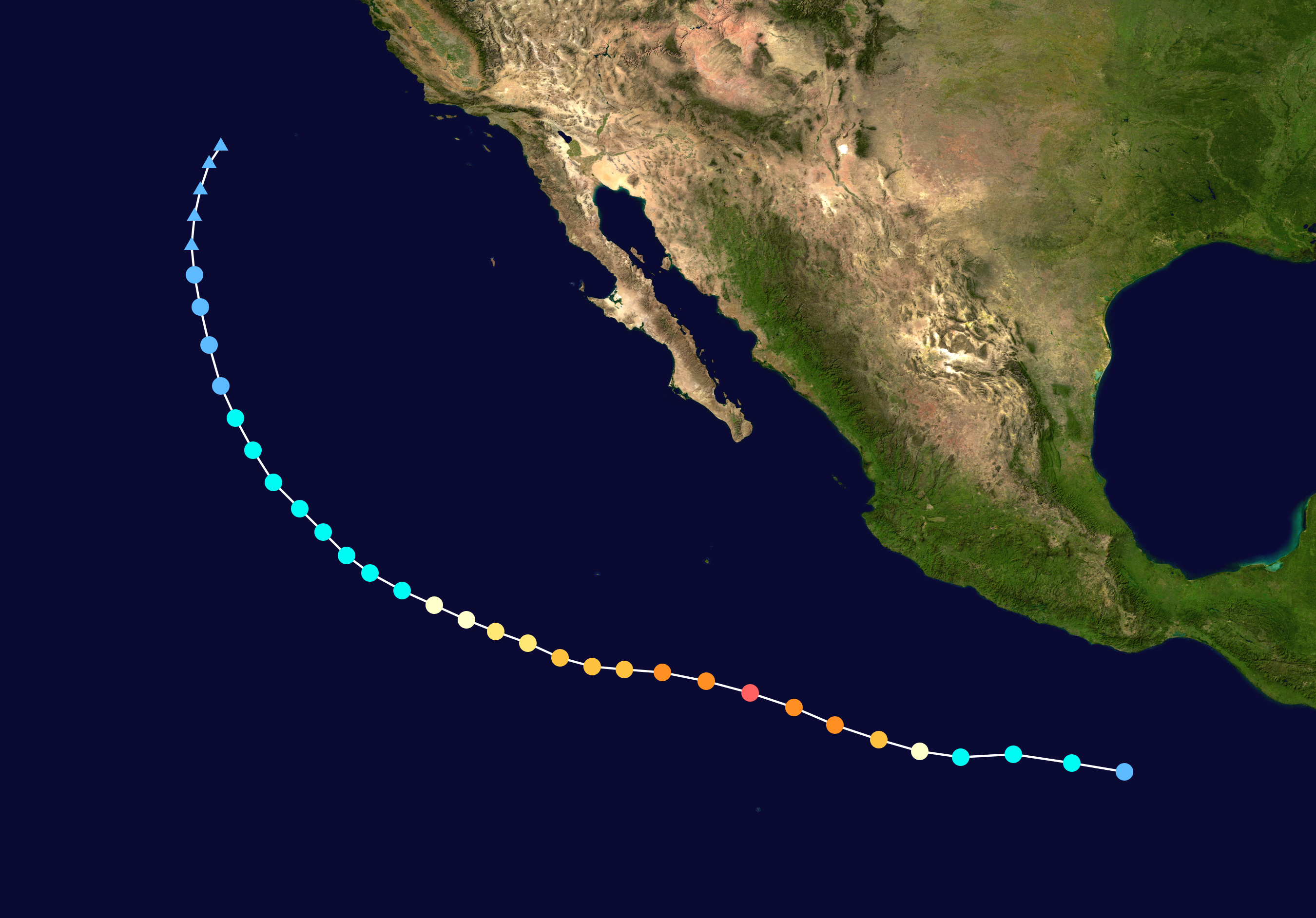
RL3AO wrote:Very very close as to if it reached cat 5. I'm sure they'll take a close look at it in post season. IMO, it was a clear enough T7.0 to go 140kt.


The storm intensified too rapidly thus "breaking constraints" to give it a Dvorak of T7.0 at 12Z. Thus gave it an FT of 6.5/6.5 at 12Z with a DT of 7.0. We bypass constraints ONLY if the average of the previous 6 hrs(including classification time) of manually derived DTs is equal the instantaneous DT. In this case it was only 6.4 so constraints were followed.
0 likes   

User avatar
Yellow Evan
Professional-Met
Professional-Met
Posts: 15956
Age: 25
Joined: Fri Jul 15, 2011 12:48 pm
Location: Henderson, Nevada/Honolulu, HI
Contact:

Re: Re:

#430 Postby Yellow Evan » Sun May 25, 2014 6:45 pm

Kingarabian wrote:I think once a storm reaches a 155 mph, it should be declared a category 5. The rule is a 156mph+... which is fine if you have an abundant resource of recon. But if you're using satellite estimates, a 1mph +/- in wind speed that makes all the difference is pretty tough.


You have to draw the line somewhere.
0 likes   

supercane4867
Category 5
Category 5
Posts: 4966
Joined: Wed Nov 14, 2012 10:43 am

Re: EPAC: AMANDA - Hurricane

#431 Postby supercane4867 » Sun May 25, 2014 6:48 pm

It seems that TAFB doesn't follow the constraints rule as much as other agencies do and thus more willing to give out T7.0s

EP, 01, 201405251200, 10, DVTS, CI,, 1170N, 11110W,, 1, 140, 2, 921, 2, DVRK,,,,,,,,,,,,,, E, TAFB, SS, I , 1, 7070 / / / / /,,, GOES15, CSC, T,

A consensus among estimates is always needed anyway
0 likes   

User avatar
Yellow Evan
Professional-Met
Professional-Met
Posts: 15956
Age: 25
Joined: Fri Jul 15, 2011 12:48 pm
Location: Henderson, Nevada/Honolulu, HI
Contact:

Re: EPAC: AMANDA - Hurricane

#432 Postby Yellow Evan » Sun May 25, 2014 7:05 pm

Image
0 likes   

User avatar
Kingarabian
S2K Supporter
S2K Supporter
Posts: 15451
Joined: Sat Aug 08, 2009 3:06 am
Location: Honolulu, Hawaii

Re: Re:

#433 Postby Kingarabian » Sun May 25, 2014 7:11 pm

Yellow Evan wrote:
Kingarabian wrote:I think once a storm reaches a 155 mph, it should be declared a category 5. The rule is a 156mph+... which is fine if you have an abundant resource of recon. But if you're using satellite estimates, a 1mph +/- in wind speed that makes all the difference is pretty tough.


You have to draw the line somewhere.


Either make it 160mph or 155mph. 156mph is too much of a tight margin.
0 likes   
RIP Kobe Bryant

RL3AO
Moderator-Pro Met
Moderator-Pro Met
Posts: 16308
Joined: Thu Jun 14, 2007 10:03 pm
Location: NC

Re: Re:

#434 Postby RL3AO » Sun May 25, 2014 7:21 pm

Kingarabian wrote:I think once a storm reaches a 155 mph, it should be declared a category 5. The rule is a 156mph+... which is fine if you have an abundant resource of recon. But if you're using satellite estimates, a 1mph +/- in wind speed that makes all the difference is pretty tough.


Should a 110 mph storm be a category 3 because its "only 1 mph" away? A Cat 5 on the SSHWS is a 1 min wind of 137kt or greater. The fact that its only 1 mph away is just the nature of converting units and rounding.
0 likes   

RL3AO
Moderator-Pro Met
Moderator-Pro Met
Posts: 16308
Joined: Thu Jun 14, 2007 10:03 pm
Location: NC

Re: Re:

#435 Postby RL3AO » Sun May 25, 2014 7:23 pm

Kingarabian wrote:
Yellow Evan wrote:
Kingarabian wrote:I think once a storm reaches a 155 mph, it should be declared a category 5. The rule is a 156mph+... which is fine if you have an abundant resource of recon. But if you're using satellite estimates, a 1mph +/- in wind speed that makes all the difference is pretty tough.


You have to draw the line somewhere.


Either make it 160mph or 155mph. 156mph is too much of a tight margin.


Remember the scale is in knots. We just convert to mph for convince.
0 likes   

User avatar
Kingarabian
S2K Supporter
S2K Supporter
Posts: 15451
Joined: Sat Aug 08, 2009 3:06 am
Location: Honolulu, Hawaii

Re: Re:

#436 Postby Kingarabian » Sun May 25, 2014 7:26 pm

RL3AO wrote:
Kingarabian wrote:


Remember the scale is in knots. We just convert to mph for convince.


Ah yeah forgot they base everything off knots. It is what is then.
0 likes   
RIP Kobe Bryant

User avatar
richard-K2013
Tropical Low
Tropical Low
Posts: 30
Age: 30
Joined: Sun Apr 06, 2014 6:59 pm
Location: Taoyuan, Taiwan

#437 Postby richard-K2013 » Sun May 25, 2014 7:27 pm

Let's see the MODIS/Terra Satellite imagery. It's so beautiful, but I think it has no chance to become a category 5 hurricane. Seems it's weakening now and the north of the system is not favorable for it to develop.

Image
Image
Image
0 likes   

User avatar
Kingarabian
S2K Supporter
S2K Supporter
Posts: 15451
Joined: Sat Aug 08, 2009 3:06 am
Location: Honolulu, Hawaii

#438 Postby Kingarabian » Sun May 25, 2014 7:33 pm

Still in pretty good shape, I have to agree.

Image
0 likes   
RIP Kobe Bryant

CrazyC83
Professional-Met
Professional-Met
Posts: 33393
Joined: Tue Mar 07, 2006 11:57 pm
Location: Deep South, for the first time!

#439 Postby CrazyC83 » Sun May 25, 2014 8:00 pm

EP, 01, 2014052600, , BEST, 0, 124N, 1114W, 125, 941, HU,
0 likes   

User avatar
euro6208
Category 5
Category 5
Posts: 18547
Joined: Mon Mar 08, 2004 7:50 pm
Location: Guam

Re: EPAC: AMANDA - Hurricane

#440 Postby euro6208 » Sun May 25, 2014 8:23 pm

Strongest May hurricane for the EPAC!!!
Last edited by euro6208 on Sun May 25, 2014 8:42 pm, edited 2 times in total.
0 likes   
Remember, all of my post aren't official. For official warnings and discussions, Please refer to your local NWS products...

NWS for the Western Pacific

https://www.weather.gov/gum/


Return to “2014”

Who is online

Users browsing this forum: No registered users and 5 guests