I noticed some easterly shear too, Gatorecane - since it's at 10N it's still stuck in the ITCZ, and just a guess that if remains an area of thunderstorms and doesn't develop soon it might remain that way as it approaches South America...
Frank2
ATL: BERTHA - Post-Tropical - Discussion
Moderator: S2k Moderators
Re: ATL: INVEST 93L - Discussion
0 likes

-
hurricanekid416
- Tropical Storm

- Posts: 179
- Joined: Wed Oct 24, 2012 2:43 pm
It looks like it's already starting to organize
0 likes
Personal Forecast Disclaimer:
The posts in this forum are NOT official forecast and should not be used as such. They are just the opinion of the poster and may or may not be backed by sound meteorological data. They are NOT endorsed by any professional institution or storm2k.org. For official information, please refer to the NHC and NWS products.
The posts in this forum are NOT official forecast and should not be used as such. They are just the opinion of the poster and may or may not be backed by sound meteorological data. They are NOT endorsed by any professional institution or storm2k.org. For official information, please refer to the NHC and NWS products.
-
cycloneye

- Admin

- Posts: 139327
- Age: 67
- Joined: Thu Oct 10, 2002 10:54 am
- Location: San Juan, Puerto Rico
Re: ATL: INVEST 93L - Discussion
Below 10N at 18z Best Track.
AL, 93, 2014072818, , BEST, 0, 98N, 338W, 20, 1011, DB
AL, 93, 2014072818, , BEST, 0, 98N, 338W, 20, 1011, DB
0 likes
Visit the Caribbean-Central America Weather Thread where you can find at first post web cams,radars
and observations from Caribbean basin members Click Here
and observations from Caribbean basin members Click Here
-
TropicalAnalystwx13

- Category 5

- Posts: 2109
- Age: 26
- Joined: Tue Jul 19, 2011 8:20 pm
- Location: Wilmington, NC
- Contact:
-
weathernerdguy

- Tropical Storm
- Posts: 188
- Age: 22
- Joined: Wed Jul 10, 2013 8:44 pm
Did 2013 look this good in the region this invest is forming at?
0 likes
The posts in this forum are NOT official forecast and should not be used as such. They are just the opinion of the poster and may or may not be backed by sound meteorological data. They are NOT endorsed by any professional institution or storm2k.org. For official information, please refer to the NHC and NWS products
-
Weatherboy1

- Category 5
- Posts: 1167
- Age: 48
- Joined: Mon Jul 05, 2004 1:50 pm
- Location: Jupiter, FL
Yes, this is clearly a nice CV style system - and relatively early too considering the real ramping up of activity is typically more like mid-August. Way too early to say whether this is an early re-curver or something more significant for the U.S. But I would certainly keep an eye on it if I were in the islands.
0 likes
-
beoumont

- Category 1

- Posts: 473
- Joined: Sun Jul 10, 2011 4:13 pm
- Location: East Central Florida
- Contact:
Re: Re:
NDG wrote:Alyono wrote:I think NHCs chances are quite low. Development chances may be closer to 60/90 at this point.
I wonder if they are giving weight to the EC solution, which would be a mistake
That is what is probably going on. They are probably waiting for the Euro to jump in. You would think that they would have given higher chances just with the HWRF forecast which did very well with Arthur and TD 2.
Since when does an NHC forecaster look at various bits of guidance, then decide which bit he should jump on?
NEVER. EVER.
Guidance is simply guidance.
Last edited by beoumont on Mon Jul 28, 2014 1:44 pm, edited 1 time in total.
0 likes
List of 79 tropical cyclones intercepted by Richard Horodner:
http://www.canebeard.com/page/page/572246.htm
http://www.canebeard.com/page/page/572246.htm
-
Weatherboy1
- Category 5
- Posts: 1167
- Age: 48
- Joined: Mon Jul 05, 2004 1:50 pm
- Location: Jupiter, FL
Re: Re:
beoumont wrote:NDG wrote:Alyono wrote:I think NHCs chances are quite low. Development chances may be closer to 60/90 at this point.
I wonder if they are giving weight to the EC solution, which would be a mistake
That is what is probably going on. They are probably waiting for the Euro to jump in. You would think that they would have given higher chances just with the HWRF forecast which did very well with Arthur and TD 2.
Since when does an NHC forecaster look at various bits of guidance, then decide which bit he should jump on?
NEVER. EVER.
Guidance is simply guidance.
All time my friend, IMO.
0 likes

Re: Re:
beoumont wrote:NDG wrote:Alyono wrote:I think NHCs chances are quite low. Development chances may be closer to 60/90 at this point.
I wonder if they are giving weight to the EC solution, which would be a mistake
That is what is probably going on. They are probably waiting for the Euro to jump in. You would think that they would have given higher chances just with the HWRF forecast which did very well with Arthur and TD 2.
Since when does an NHC forecaster look at various bits of guidance, then decide which bit he should jump on?
NEVER. EVER.
Guidance is simply guidance.
There is NOTHING constructive that can be said about the above post
0 likes


-
Evil Jeremy

- S2K Supporter

- Posts: 5459
- Age: 31
- Joined: Mon Apr 10, 2006 2:10 pm
- Location: Los Angeles, CA
Re: Re:
beoumont wrote:NDG wrote:Alyono wrote:I think NHCs chances are quite low. Development chances may be closer to 60/90 at this point.
I wonder if they are giving weight to the EC solution, which would be a mistake
That is what is probably going on. They are probably waiting for the Euro to jump in. You would think that they would have given higher chances just with the HWRF forecast which did very well with Arthur and TD 2.
Since when does an NHC forecaster look at various bits of guidance, then decide which bit he should jump on?
NEVER. EVER.
Guidance is simply guidance.
Debby, 2012
0 likes
Frances 04 / Jeanne 04 / Katrina 05 / Wilma 05 / Fay 08 / Debby 12 / Andrea 13 / Colin 16 / Hermine 16 / Matthew 16 / Irma 17


-
TheStormExpert

- Category 5
- Posts: 8487
- Age: 30
- Joined: Wed Feb 16, 2011 5:38 pm
- Location: Palm Beach Gardens, FL
Re:
Alyono wrote:I think NHCs chances are quite low. Development chances may be closer to 60/90 at this point.
I wonder if they are giving weight to the EC solution, which would be a mistake
I would assume their doing a blend of both the GFS and Euro.
0 likes
The following post is NOT an official forecast and should not be used as such. It is just the opinion of the poster and may or may not be backed by sound meteorological data. It is NOT endorsed by storm2k.org.
-
TheStormExpert
- Category 5
- Posts: 8487
- Age: 30
- Joined: Wed Feb 16, 2011 5:38 pm
- Location: Palm Beach Gardens, FL
Re:
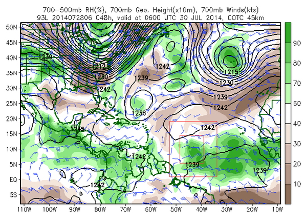
RL3AO wrote:Just a quick comparison of 700mb RH values for 02L and 93L.
02L
93L
Looks like a surge of moist air is following in 93L's path.
0 likes
The following post is NOT an official forecast and should not be used as such. It is just the opinion of the poster and may or may not be backed by sound meteorological data. It is NOT endorsed by storm2k.org.
-
TheStormExpert
- Category 5
- Posts: 8487
- Age: 30
- Joined: Wed Feb 16, 2011 5:38 pm
- Location: Palm Beach Gardens, FL
Re: ATL: INVEST 93L - Discussion
Frank2 wrote:I noticed some easterly shear too, Gatorecane - since it's at 10N it's still stuck in the ITCZ, and just a guess that if remains an area of thunderstorms and doesn't develop soon it might remain that way as it approaches South America...
Frank2
Shear doesn't seem to be too big of an issue from my standpoint.


0 likes
The following post is NOT an official forecast and should not be used as such. It is just the opinion of the poster and may or may not be backed by sound meteorological data. It is NOT endorsed by storm2k.org.
-
cycloneye
- Admin
- Posts: 139327
- Age: 67
- Joined: Thu Oct 10, 2002 10:54 am
- Location: San Juan, Puerto Rico
Re: ATL: INVEST 93L - Discussion
Sun almost setting in the area.

0 likes
Visit the Caribbean-Central America Weather Thread where you can find at first post web cams,radars
and observations from Caribbean basin members Click Here
and observations from Caribbean basin members Click Here

Who is online
Users browsing this forum: No registered users and 7 guests