ATL: ARTHUR - Models

Moderator: S2k Moderators

Message
Author
User avatar
NDG
S2K Supporter
S2K Supporter
Posts: 14935
Joined: Sun Jul 09, 2006 10:14 pm
Location: Orlando, FL

Re:

#81 Postby NDG » Sun Jun 29, 2014 7:15 pm

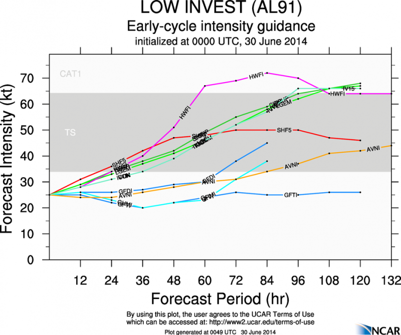
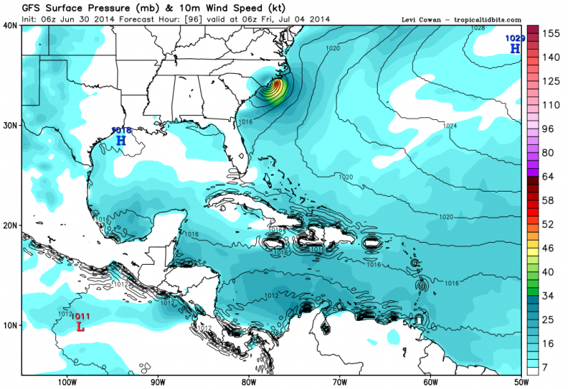
Alyono wrote:the thing that worries me about development is that the Canadian does not develop this

If even the Canadian does not develop something, that is a red flag


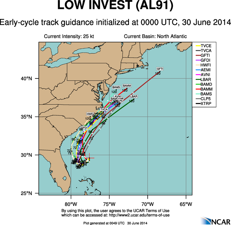
True, but the Canadian for the last couple of days has been relentless of turning it out to sea into the higher shear instead of turning it westward.
0 likes   

User avatar
NDG
S2K Supporter
S2K Supporter
Posts: 14935
Joined: Sun Jul 09, 2006 10:14 pm
Location: Orlando, FL

Re: ATL: INVEST 91L - Models

#82 Postby NDG » Sun Jun 29, 2014 8:00 pm

0z early model run, much better concensus.
Regarding intensity the Euro is getting some company.

Image
Image
0 likes   

User avatar
NDG
S2K Supporter
S2K Supporter
Posts: 14935
Joined: Sun Jul 09, 2006 10:14 pm
Location: Orlando, FL

#83 Postby NDG » Sun Jun 29, 2014 8:12 pm

0z HWFI goes nuts strengthwise, turns 91L into a hurricane by Wednesday morning off the coast of FL then make landfall in SC/NC border Friday morning.

Image
Image
0 likes   

User avatar
northjaxpro
S2K Supporter
S2K Supporter
Posts: 8900
Joined: Mon Sep 27, 2010 11:21 am
Location: Jacksonville, FL

#84 Postby northjaxpro » Sun Jun 29, 2014 8:16 pm

Yeah, the models are now coming in line of stalling out the cyclone off the FL East Coast and pulling north /northeast with an impact to the NC coast.
0 likes   
NEVER, EVER SAY NEVER in the tropics and weather in general, and most importantly, with life itself!!

________________________________________________________________________________________

Fay 2008 Beryl 2012 Debby 2012 Colin 2016 Hermine 2016 Julia 2016 Matthew 2016 Irma 2017 Dorian 2019

User avatar
TheStormExpert
Category 5
Category 5
Posts: 8487
Age: 30
Joined: Wed Feb 16, 2011 5:38 pm
Location: Palm Beach Gardens, FL

#85 Postby TheStormExpert » Sun Jun 29, 2014 8:54 pm

Just looked up Hurricane Alex(2004) on Wikipedia to get a sense of it's Meteorological history and overall it looks very similar to what the models are showing MAY happen with 91L. It struggled at first until the approaching trough that turned it NE bought better conditions.
http://en.wikipedia.org/wiki/Hurricane_Alex_(2004)
0 likes   
The following post is NOT an official forecast and should not be used as such. It is just the opinion of the poster and may or may not be backed by sound meteorological data. It is NOT endorsed by storm2k.org.

Alyono
Professional-Met
Professional-Met
Posts: 6961
Joined: Fri Apr 26, 2013 3:52 pm
Location: Texas Coast

#86 Postby Alyono » Sun Jun 29, 2014 11:05 pm

0Z GFS does seem to be developing this, but not until Thu/Fri
0 likes   

Alyono
Professional-Met
Professional-Met
Posts: 6961
Joined: Fri Apr 26, 2013 3:52 pm
Location: Texas Coast

#87 Postby Alyono » Sun Jun 29, 2014 11:05 pm

Alex was in August. This is June/early July

A better analog may be Cristobal from 2008
0 likes   

User avatar
TheStormExpert
Category 5
Category 5
Posts: 8487
Age: 30
Joined: Wed Feb 16, 2011 5:38 pm
Location: Palm Beach Gardens, FL

Re:

#88 Postby TheStormExpert » Sun Jun 29, 2014 11:10 pm

Alyono wrote:Alex was in August. This is June/early July

A better analog may be Cristobal from 2008

I meant track wise and it's evolution, strength wise it shouldn't even come close! :lol:
0 likes   
The following post is NOT an official forecast and should not be used as such. It is just the opinion of the poster and may or may not be backed by sound meteorological data. It is NOT endorsed by storm2k.org.

Alyono
Professional-Met
Professional-Met
Posts: 6961
Joined: Fri Apr 26, 2013 3:52 pm
Location: Texas Coast

#89 Postby Alyono » Mon Jun 30, 2014 12:38 am

Cristobal moved to the NE. That likely is the analog, NOT Alex

0Z Canadian now does develop this once it starts moving to the NE.
0 likes   

Alyono
Professional-Met
Professional-Met
Posts: 6961
Joined: Fri Apr 26, 2013 3:52 pm
Location: Texas Coast

#90 Postby Alyono » Mon Jun 30, 2014 1:29 am

0Z EC has a fairly intense hurricane skirting east NC, similar to Alex
0 likes   

supercane4867
Category 5
Category 5
Posts: 4966
Joined: Wed Nov 14, 2012 10:43 am

Re: ATL: INVEST 91L - Models

#91 Postby supercane4867 » Mon Jun 30, 2014 1:44 am

00z ECMWF brings wind gust well over 100mph for the Outer Banks
0 likes   

User avatar
NDG
S2K Supporter
S2K Supporter
Posts: 14935
Joined: Sun Jul 09, 2006 10:14 pm
Location: Orlando, FL

#92 Postby NDG » Mon Jun 30, 2014 5:08 am

06z GFS starting to come along with the Euro, it does not do much with it over the next 60 hrs or so because it has it if not making landfall very close to the eastern FL coast as it starts heading north.

Image
0 likes   

User avatar
ronjon
Category 5
Category 5
Posts: 4672
Joined: Fri Aug 19, 2005 5:17 pm
Location: Hernando Beach, FL

Re: ATL: INVEST 91L - Models

#93 Postby ronjon » Mon Jun 30, 2014 5:53 am

Yeah NDG, the 06z GFS brings the low as far west as Lake O and then drifts it north up the spine of the peninsula the next two days before emerging off the Georgia coast.

http://www.tropicaltidbits.com/analysis/models/gfs/2014063006/gfs_mslp_uv850_atltropics.html
0 likes   

User avatar
NDG
S2K Supporter
S2K Supporter
Posts: 14935
Joined: Sun Jul 09, 2006 10:14 pm
Location: Orlando, FL

#94 Postby NDG » Mon Jun 30, 2014 6:04 am

06z HWFI shifted west, making landfall near Port St Lucie as a weak low then move along the coast gaining strength as it does so.

Image
Image
Image
0 likes   

User avatar
cycloneye
Admin
Admin
Posts: 139567
Age: 67
Joined: Thu Oct 10, 2002 10:54 am
Location: San Juan, Puerto Rico

Re: ATL: INVEST 91L - Models

#95 Postby cycloneye » Mon Jun 30, 2014 6:25 am

00z UKMET.

NEW TROPICAL STORM FORECAST TO DEVELOP AFTER 6 HOURS

FORECAST POSITION AT T+ 6 : 28.8N 77.9W


VERIFYING TIME POSITION STRENGTH TENDENCY

-------------- -------- -------- --------

12UTC 30.06.2014 28.1N 78.3W WEAK LITTLE CHANGE

00UTC 01.07.2014 27.0N 78.8W WEAK LITTLE CHANGE

12UTC 01.07.2014 27.0N 79.1W WEAK LITTLE CHANGE

00UTC 02.07.2014 27.7N 79.5W WEAK LITTLE CHANGE

12UTC 02.07.2014 29.1N 79.1W WEAK INTENSIFYING SLIGHTLY

00UTC 03.07.2014 30.2N 79.5W WEAK INTENSIFYING SLIGHTLY

12UTC 03.07.2014 31.8N 79.1W MODERATE INTENSIFYING SLIGHTLY

00UTC 04.07.2014 33.6N 77.6W MODERATE LITTLE CHANGE

12UTC 04.07.2014 35.8N 75.1W MODERATE LITTLE CHANGE

00UTC 05.07.2014 38.4N 71.9W INTENSE INTENSIFYING RAPIDLY

12UTC 05.07.2014 40.8N 67.4W INTENSE INTENSIFYING RAPIDLY

00UTC 06.07.2014 43.6N 63.1W INTENSE LITTLE CHANGE
0 likes   
Visit the Caribbean-Central America Weather Thread where you can find at first post web cams,radars
and observations from Caribbean basin members Click Here

HURRICANELONNY
Category 5
Category 5
Posts: 1381
Joined: Wed May 07, 2003 6:48 am
Location: HOLLYWOOD.FL

#96 Postby HURRICANELONNY » Mon Jun 30, 2014 6:46 am

Not until Recon gets out there this morning will we know what and where it could go. Most likely future Arthur will go north at some point but without a true center llc then what's the point. :D
0 likes   
hurricanelonny

tolakram
Admin
Admin
Posts: 19180
Age: 60
Joined: Sun Aug 27, 2006 8:23 pm
Location: Florence, KY (name is Mark)

Re: ATL: INVEST 91L - Models

#97 Postby tolakram » Mon Jun 30, 2014 7:27 am

So the 12Z euro still blows this up right off the coast while the GFS now shows it but still has it moving inland a few times, which is why it keeps the storm weaker IMO. Remind me, which model has the left bias?
0 likes   
M a r k
- - - - -
Join us in chat: Storm2K Chatroom Invite. Android and IOS apps also available.

The posts in this forum are NOT official forecasts and should not be used as such. Posts are NOT endorsed by any professional institution or STORM2K.org. For official information and forecasts, please refer to NHC and NWS products.

User avatar
srainhoutx
S2K Supporter
S2K Supporter
Posts: 6919
Age: 66
Joined: Sun Jan 14, 2007 11:34 am
Location: Haywood County, NC
Contact:

Re: ATL: INVEST 91L - Models

#98 Postby srainhoutx » Mon Jun 30, 2014 7:39 am

tolakram wrote:So the 12Z euro still blows this up right off the coast while the GFS now shows it but still has it moving inland a few times, which is why it keeps the storm weaker IMO. Remind me, which model has the left bias?


The Euro... :wink:
0 likes   
Carla/Alicia/Jerry(In The Eye)/Michelle/Charley/Ivan/Dennis/Katrina/Rita/Wilma/Ike/Harvey

Member: National Weather Association
Wx Infinity Forums
http://wxinfinity.com/index.php

Facebook.com/WeatherInfinity
Twitter @WeatherInfinity

tolakram
Admin
Admin
Posts: 19180
Age: 60
Joined: Sun Aug 27, 2006 8:23 pm
Location: Florence, KY (name is Mark)

Re: ATL: INVEST 91L - Models

#99 Postby tolakram » Mon Jun 30, 2014 7:47 am

Interesting. :)

http://ruc.noaa.gov/hfip/tcgen/

UK and Euro now have a very similar idea for a west loop back to the NE and developing fairly rapidly. If you compare all the day 3 (D3) plots for all the models they are now in pretty good agreement. Looking at V85 (vorticity 850MB) gives a good idea which models expect this to hit the coast and which ones keep it off shore.
0 likes   
M a r k
- - - - -
Join us in chat: Storm2K Chatroom Invite. Android and IOS apps also available.

The posts in this forum are NOT official forecasts and should not be used as such. Posts are NOT endorsed by any professional institution or STORM2K.org. For official information and forecasts, please refer to NHC and NWS products.

User avatar
NDG
S2K Supporter
S2K Supporter
Posts: 14935
Joined: Sun Jul 09, 2006 10:14 pm
Location: Orlando, FL

Re: ATL: INVEST 91L - Models

#100 Postby NDG » Mon Jun 30, 2014 9:00 am

Very concensus from 12z early model runs. All now agreeing in it becoming a tropical storm, even the GFS.
Image
Image
0 likes   


Return to “2014”

Who is online

Users browsing this forum: No registered users and 39 guests