NIO: NANAUK - Cyclonic Storm

Moderator: S2k Moderators

Message
Author
Meow

Re: NIO: ARB 01 - Depression (TC 02A)

#21 Postby Meow » Tue Jun 10, 2014 2:03 pm

Grifforzer wrote:Considering numerical weather prediction models, GFS continues to show cyclonic storm with west northwestward movement towards moan coast till 0000 UTC, Saturday and then recurves towards northeast and weakening of the system over sea. ECMWF, Meteo France and UKMO models indicate maximum intensification up to depression/deep depression during the next 72 hours with north westward movement and weakening of the system thereafter. JMA model shows initial northwestward movement up to 60 hours and then westward movement with gradual intensification up to severe cyclonic storm during the 72 hours. Hence, there is a large variation in the track and intensity prediction by the models.

Looks like JMA does better job than IMD in this basin.
0 likes   

User avatar
Hurricane_Luis
Category 2
Category 2
Posts: 723
Age: 25
Joined: Sat Jun 23, 2012 3:14 pm
Location: Tiptree, Essex, United Kingdom
Contact:

#22 Postby Hurricane_Luis » Tue Jun 10, 2014 2:18 pm

How is this not named yet I don't Know. All I know is IMD are underestimating this system a lot. 02A is above TS intensity.

Image
0 likes   

Meow

#23 Postby Meow » Tue Jun 10, 2014 2:41 pm

An unnamed 50-knot cyclone

Image
Last edited by Meow on Wed Jun 11, 2014 12:14 am, edited 1 time in total.
0 likes   

Meow

#24 Postby Meow » Tue Jun 10, 2014 2:44 pm

1745Z satellite bulletin:

VORTEX:-
VORTEX OVER EC ARSEA CENTERED NEAR 16.5N/67.6E (.) INTENSITY T2.0 RPT T2.0(.) ASSTD BKN LOW/MED CLOUDS WITH EMBDD INT TO V INT CONVTN OVER ARSEA BET LAT 11.0N TO 19.5N LONG 60.5E TO 70.5E (.)

:roll:
0 likes   

Alyono
Professional-Met
Professional-Met
Posts: 6961
Joined: Fri Apr 26, 2013 3:52 pm
Location: Texas Coast

#25 Postby Alyono » Tue Jun 10, 2014 3:03 pm

whatever IMD is smoking, it must be pretty good... even better than an Indonesian cigarette
0 likes   

supercane4867
Category 5
Category 5
Posts: 4966
Joined: Wed Nov 14, 2012 10:43 am

Re: NIO: ARB 01 - Depression (TC 02A)

#26 Postby supercane4867 » Tue Jun 10, 2014 3:15 pm

It is the IMD as always...just get use to it lol
0 likes   

alhddar
Tropical Depression
Tropical Depression
Posts: 62
Joined: Sun Feb 17, 2008 4:27 am

93A INVEST

#27 Postby alhddar » Tue Jun 10, 2014 3:30 pm

Image
0 likes   

alhddar
Tropical Depression
Tropical Depression
Posts: 62
Joined: Sun Feb 17, 2008 4:27 am

#28 Postby alhddar » Tue Jun 10, 2014 3:32 pm

Image
0 likes   

alhddar
Tropical Depression
Tropical Depression
Posts: 62
Joined: Sun Feb 17, 2008 4:27 am

#29 Postby alhddar » Tue Jun 10, 2014 3:32 pm

Time of issue: 1630 hours IST Dated: 10.06.2014
Bulletin No.: ARB01/2014/01
Sub: Depression over eastcentral Arabian Sea.
Latest satellite imagery and observations indicate that a depression has formed
over eastcentral Arabian Sea and lay centred at 1430 hours IST of today, the 10th June, 2014 near
latitude 15.50 N and longitude 68.50 E, about 610 km southwest of Mumbai, 630 km southsouthwest
of Veraval and 1160 km southeast of Masirah Island (Oman). It would move northnorthwestwards
and intensify further into a deep depression during next 24 hrs. Subsequently it
would move west-northwestwards towards Oman coast.
Under the influence of this system, rainfall would occur at most places with isolated heavy
falls over coastal Karnataka, Kerala and Lakshadweep during the next 24 hours.
Strong winds speed reaching 35-45 kmph gusting to 55 kmph would prevail along and off
Konkan and south Gujarat coast during next 48 hrs. Sea condition would be rough along and off
Konkan , Goa and south Gujarat coast during the same period.
Fishermen along and off Konkan and south Gujarat coasts are advised to be cautious
while venturing into the Sea during next 48 hours.
The next bulletin will be issued at 2030 hrs IST of today, the 10th June, 2014.
0 likes   

User avatar
euro6208
Category 5
Category 5
Posts: 18547
Joined: Mon Mar 08, 2004 7:50 pm
Location: Guam

Re: NIO: ARB 01 - Depression (TC 02A)

#30 Postby euro6208 » Tue Jun 10, 2014 7:06 pm

02A TWO 140610 1800 16.5N 67.8E IO 50 985

Indeed, up to 50 knots!
0 likes   
Remember, all of my post aren't official. For official warnings and discussions, Please refer to your local NWS products...

NWS for the Western Pacific

https://www.weather.gov/gum/

User avatar
xtyphooncyclonex
Category 5
Category 5
Posts: 3688
Age: 22
Joined: Sat Dec 08, 2012 9:07 am
Location: Cebu City
Contact:

#31 Postby xtyphooncyclonex » Tue Jun 10, 2014 8:03 pm

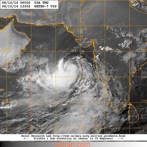
A mid-to-strong TS would be the most reasonable estimate, based on Dvorak and imagery. And I am surprised that the IMD only has this as a weak Depression, and that 3-minute wind speeds are not too far away from 1-minute wind speeds.
0 likes   
REMINDER: My opinions that I, or any other NON Pro-Met in this forum, are unofficial. Please do not take my opinions as an official forecast and warning. I am NOT a meteorologist. Following my forecasts blindly may lead to false alarm, danger and risk if official forecasts from agencies are ignored.

User avatar
xtyphooncyclonex
Category 5
Category 5
Posts: 3688
Age: 22
Joined: Sat Dec 08, 2012 9:07 am
Location: Cebu City
Contact:

#32 Postby xtyphooncyclonex » Tue Jun 10, 2014 8:05 pm

If this were in the WPAC, it would be given probably 40-55 knts by the TS-bullish JMA. 10-minute winds are longer than both 1-min & 3-min.
0 likes   
REMINDER: My opinions that I, or any other NON Pro-Met in this forum, are unofficial. Please do not take my opinions as an official forecast and warning. I am NOT a meteorologist. Following my forecasts blindly may lead to false alarm, danger and risk if official forecasts from agencies are ignored.

User avatar
euro6208
Category 5
Category 5
Posts: 18547
Joined: Mon Mar 08, 2004 7:50 pm
Location: Guam

Re:

#33 Postby euro6208 » Tue Jun 10, 2014 8:15 pm

xtyphooncyclonex wrote:If this were in the WPAC, it would be given probably 40-55 knts by the TS-bullish JMA. 10-minute winds are longer than both 1-min & 3-min.


Up to 55 knots!

02A TWO 140611 0000 16.9N 67.1E IO 55 982

Most likely JMA only gives this 35 knots but JTWC gives this 55 knots based on dvorak numbers almost reaching 3.5 and the above 0Z best track update.
0 likes   
Remember, all of my post aren't official. For official warnings and discussions, Please refer to your local NWS products...

NWS for the Western Pacific

https://www.weather.gov/gum/

Meow

Re: Re:

#34 Postby Meow » Tue Jun 10, 2014 8:26 pm

euro6208 wrote:Most likely JMA only gives this 35 knots but JTWC gives this 55 knots based on dvorak numbers almost reaching 3.5 and the above 0Z best track update.

Poor IMD... :froze:
0 likes   

User avatar
euro6208
Category 5
Category 5
Posts: 18547
Joined: Mon Mar 08, 2004 7:50 pm
Location: Guam

Re: NIO: ARB 01 - Deep Depression (TC 02A)

#35 Postby euro6208 » Tue Jun 10, 2014 8:27 pm

Image
0 likes   
Remember, all of my post aren't official. For official warnings and discussions, Please refer to your local NWS products...

NWS for the Western Pacific

https://www.weather.gov/gum/

User avatar
Steve820
Tropical Storm
Tropical Storm
Posts: 188
Age: 24
Joined: Sat May 17, 2014 8:04 pm
Location: Southern California
Contact:

#36 Postby Steve820 » Tue Jun 10, 2014 8:49 pm

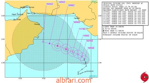
Well, here comes the next named storm in the NIO, if it's named it will be Na-nauk. It looks impressive on satellite imagery, since the JTWC appears to give it an intensity of 55 knots, I can't believe it hasn't been named yet! Checking out the forecast track, Oman might have to watch out in the long term.
0 likes   
Hurricanes are an amazing natural phenomena. While many are spiraling pits of evil that kill people or cause devastation, some are tame and stay clear of land.

I wish for you to :Bcool:

User avatar
Macrocane
Category 5
Category 5
Posts: 4218
Age: 35
Joined: Sun May 24, 2009 5:35 pm
Location: El Salvador

Re: NIO: ARB 01 - Deep Depression (TC 02A)

#37 Postby Macrocane » Tue Jun 10, 2014 10:36 pm

WMO must do something to help IMD with cyclones forecasting and monitoring, it is by far the worst RSMC, sorry for the bashing but it is. I wonder what will the intensity be in the first advisory, it could be near hurricane strength by that time!
0 likes   

Grifforzer
Category 1
Category 1
Posts: 418
Joined: Thu Feb 26, 2009 11:27 pm

Re: NIO: ARB 01 - Deep Depression (TC 02A)

#38 Postby Grifforzer » Tue Jun 10, 2014 10:39 pm

IMD Satellite Bulletin message

VORTEX OVER ARABIAN SEA CENTERED NEAR 16.5N/67.2E(.) INTENSITY T2.5 RPT T2.5(.)
0 likes   

supercane4867
Category 5
Category 5
Posts: 4966
Joined: Wed Nov 14, 2012 10:43 am

Re: NIO: ARB 01 - Deep Depression (TC 02A)

#39 Postby supercane4867 » Tue Jun 10, 2014 10:50 pm

"Unnamed Depression"

Image
0 likes   

Meow

#40 Postby Meow » Tue Jun 10, 2014 11:12 pm

Finally... :ggreen:

Cyclonic Storm ‘NANAUK’ over eastcentral Arabian Sea.
The deep depression over eastcentral Arabian Sea moved slowly westwards, intensified into a cyclonic storm ‘NANAUK’ and lay centred at 0530 hours IST of today, the 11th June, 2014 near latitude 16.50 N and longitude 67.20 E, about 660 km southwest of Mumbai, 590 km south-southwest of Veraval and 990 km southeast of Masirah Island (Oman). It would intensify further into a severe cyclonic storm during next 24 hrs. It would move west-northwestwards towards Oman coast during next 72 hrs
0 likes   


Return to “2014”

Who is online

Users browsing this forum: No registered users and 40 guests