Morning everyone,
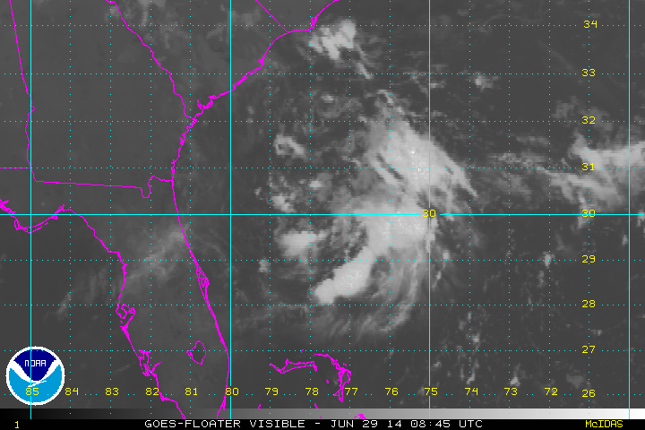
Looking at the visible Sat loop seems all the convection is on the east side from south to north. But nothing to the west to speak of, if this is going to get going, it better start producing some storms on the west side to get pulled in to the COC.
ATL: ARTHUR - Post-Tropical - Discussion
Moderator: S2k Moderators
-
Miami Storm Tracker

- Category 3

- Posts: 893
- Age: 66
- Joined: Sun Jun 13, 2010 10:12 pm
- Location: Key Largo, Fla.
- Contact:
Re: ATL: INVEST 91L - Discussion
0 likes
-
northjaxpro

- S2K Supporter

- Posts: 8900
- Joined: Mon Sep 27, 2010 11:21 am
- Location: Jacksonville, FL
0 likes
NEVER, EVER SAY NEVER in the tropics and weather in general, and most importantly, with life itself!!
________________________________________________________________________________________
Fay 2008 Beryl 2012 Debby 2012 Colin 2016 Hermine 2016 Julia 2016 Matthew 2016 Irma 2017 Dorian 2019
________________________________________________________________________________________
Fay 2008 Beryl 2012 Debby 2012 Colin 2016 Hermine 2016 Julia 2016 Matthew 2016 Irma 2017 Dorian 2019
-
Miami Storm Tracker
- Category 3
- Posts: 893
- Age: 66
- Joined: Sun Jun 13, 2010 10:12 pm
- Location: Key Largo, Fla.
- Contact:
Re: ATL: INVEST 91L - Discussion
I agree with you north,
am a bit curious how far south and west this might drift before getting picked up and turned to the NE.
am a bit curious how far south and west this might drift before getting picked up and turned to the NE.
0 likes


-
Miami Storm Tracker
- Category 3
- Posts: 893
- Age: 66
- Joined: Sun Jun 13, 2010 10:12 pm
- Location: Key Largo, Fla.
- Contact:
Re: ATL: INVEST 91L - Discussion
nice shot Gator,
Just when I post about the lack of storms to the west of the COC, I can see them forming and rapping around.
Just when I post about the lack of storms to the west of the COC, I can see them forming and rapping around.
0 likes

Re: ATL: INVEST 91L - Discussion
Miami Storm Tracker wrote:I agree with you north,
am a bit curious how far south and west this might drift before getting picked up and turned to the NE.
Yesterday recon was thinking 30.0N 78.0W at 15:45 PM. Actual position should be at least a half degree further both south and east. That is a big difference for the models to catch up on. Means the system spends more time over simmering gulf stream waters and will respond to the next front later.
I'm surprised storm2k hasn't been flooded with posts yet, guess most posters don't see the potential from satellite presentation.
0 likes
-
'CaneFreak

- Category 5

- Posts: 1475
- Joined: Mon Jun 05, 2006 10:50 am
- Location: New Bern, NC
Main problem is the fact that this thing is still attached to the front.
http://www.hpc.ncep.noaa.gov/sfc/90fwbg.gif
http://www.hpc.ncep.noaa.gov/sfc/90fwbg.gif
0 likes
-
CFLHurricane

- Category 1

- Posts: 312
- Joined: Thu Mar 27, 2014 5:56 pm
- Location: Floriduh
Re: ATL: INVEST 91L - Discussion
So is when is this likely to threaten florida, if at all?
And at what strength?
And at what strength?
0 likes
I'm not a meteorologist, but I did stay at a motel 8.
-
weathernerdguy

- Tropical Storm

- Posts: 188
- Age: 22
- Joined: Wed Jul 10, 2013 8:44 pm
it would be a 50 mph tropical storm at most to me. That's if it would manage to make landfall in Florida
0 likes
The posts in this forum are NOT official forecast and should not be used as such. They are just the opinion of the poster and may or may not be backed by sound meteorological data. They are NOT endorsed by any professional institution or storm2k.org. For official information, please refer to the NHC and NWS products
-
tropicwatch

- Category 5
- Posts: 3205
- Age: 60
- Joined: Sat Jun 02, 2007 10:01 am
- Location: Panama City Florida
- Contact:
Re: ATL: INVEST 91L - Discussion
Still a fairly impressive circulation and a possible westward drift starting.
0 likes
Tropicwatch
Agnes 72', Eloise 75, Elena 85', Kate 85', Charley 86', Florence 88', Beryl 94', Dean 95', Erin 95', Opal 95', Earl 98', Georges 98', Ivan 2004', Arlene 2005', Dennis 2005', Ida 2009' Debby 2012' Irma 2017' Michael 2018'
Agnes 72', Eloise 75, Elena 85', Kate 85', Charley 86', Florence 88', Beryl 94', Dean 95', Erin 95', Opal 95', Earl 98', Georges 98', Ivan 2004', Arlene 2005', Dennis 2005', Ida 2009' Debby 2012' Irma 2017' Michael 2018'

Re:
'CaneFreak wrote:Main problem is the fact that this thing is still attached to the front.
http://www.hpc.ncep.noaa.gov/sfc/90fwbg.gif
I really disagree with this image, there's is a front but is a good 150-200 miles north of 91L, IMO.
0 likes
-
northjaxpro
- S2K Supporter
- Posts: 8900
- Joined: Mon Sep 27, 2010 11:21 am
- Location: Jacksonville, FL
Re: ATL: INVEST 91L - Discussion
CFLHurricane wrote:So is when is this likely to threaten florida, if at all?
And at what strength?
As far as when this system could impact the East Coast of Florida, this could happen as early as tomorrow night into Tuesday. The models are coming into general agreement that 91L will loop to the southwest and impact the Florida coast or at least brush up the coast before being picked up by the trough by mid week. But, for me, how far south 91L drifts will be the key factor. The longer it drifts more south, I think it would allow for the system to sit out over the Gulf Stream for a longer period of time and thus could allow for 91L to strengthen into a formidable tropical cyclone.
Lots to pay attention to in the next 72 hours for sure.
0 likes
NEVER, EVER SAY NEVER in the tropics and weather in general, and most importantly, with life itself!!
________________________________________________________________________________________
Fay 2008 Beryl 2012 Debby 2012 Colin 2016 Hermine 2016 Julia 2016 Matthew 2016 Irma 2017 Dorian 2019
________________________________________________________________________________________
Fay 2008 Beryl 2012 Debby 2012 Colin 2016 Hermine 2016 Julia 2016 Matthew 2016 Irma 2017 Dorian 2019
-
AJC3

- Admin

- Posts: 3872
- Age: 60
- Joined: Tue Aug 31, 2004 7:04 pm
- Location: West Melbourne, Florida
- Contact:
Re:
'CaneFreak wrote:Main problem is the fact that this thing is still attached to the front.
http://www.hpc.ncep.noaa.gov/sfc/90fwbg.gif
That's not really a problem. While that frontal boundary is drawn down toward the low center, surface and C-Man reports don't support it being that far south. The temperature and dew point discontinuity is diffuse, shallow and displaced well to the north of the low center. Any air mass change in the northern quadrant of the circulation has pretty much been modified by the warm ocean temps.
0 likes
-
'CaneFreak
- Category 5
- Posts: 1475
- Joined: Mon Jun 05, 2006 10:50 am
- Location: New Bern, NC
Re: Re:
Awful lot of dry air though
AJC3 wrote:'CaneFreak wrote:Main problem is the fact that this thing is still attached to the front.
http://www.hpc.ncep.noaa.gov/sfc/90fwbg.gif
That's not really a problem. While that frontal boundary is drawn down toward the low center, surface and C-Man reports don't support it being that far south. The temperature and dew point discontinuity is diffuse, shallow and displaced well to the north of the low center. Any air mass change in the northern quadrant of the circulation has pretty much been modified by the warm ocean temps.
0 likes
-
cycloneye

- Admin
- Posts: 139060
- Age: 67
- Joined: Thu Oct 10, 2002 10:54 am
- Location: San Juan, Puerto Rico
Re: ATL: INVEST 91L - Discussion
0 likes
Visit the Caribbean-Central America Weather Thread where you can find at first post web cams,radars
and observations from Caribbean basin members Click Here
and observations from Caribbean basin members Click Here
-
AJC3
- Admin
- Posts: 3872
- Age: 60
- Joined: Tue Aug 31, 2004 7:04 pm
- Location: West Melbourne, Florida
- Contact:
Re: Re:
'CaneFreak wrote:Awful lot of dry air thoughAJC3 wrote:'CaneFreak wrote:Main problem is the fact that this thing is still attached to the front.
http://www.hpc.ncep.noaa.gov/sfc/90fwbg.gif
That's not really a problem. While that frontal boundary is drawn down toward the low center, surface and C-Man reports don't support it being that far south. The temperature and dew point discontinuity is diffuse, shallow and displaced well to the north of the low center. Any air mass change in the northern quadrant of the circulation has pretty much been modified by the warm ocean temps.
Right, but it's not a frontal low per your OP.
0 likes
Re: ATL: INVEST 91L - Discussion
still looks like a lot of shear right now..might get it together fairly rapidly once that relaxes...
Personal Forecast Disclaimer:
The posts in this forum are NOT official forecast and should not be used as such. They are just the opinion of the poster and may or may not be backed by sound meteorological data. They are NOT endorsed by any professional institution or storm2k.org. For official information, please refer to the NHC and NWS products.
0 likes
Ginger-(eye),Dennis,Diana,Kate,Gloria,Charley-(eye),Allison,Arthur,Bertha,Fran,Josephine,Bonnie,Earl,Dennis-(twice),Floyd, Isabel-(eye),Charley,Ophelia-(eyewall),Ernesto,Barry,Hanna,Irene-(eye),Arthur-(eye), Florence, Dorian, and countless depressions, storms, and nor'easters.
Re: Re:
'CaneFreak wrote:Awful lot of dry air thoughAJC3 wrote:'CaneFreak wrote:Main problem is the fact that this thing is still attached to the front.
http://www.hpc.ncep.noaa.gov/sfc/90fwbg.gif
That's not really a problem. While that frontal boundary is drawn down toward the low center, surface and C-Man reports don't support it being that far south. The temperature and dew point discontinuity is diffuse, shallow and displaced well to the north of the low center. Any air mass change in the northern quadrant of the circulation has pretty much been modified by the warm ocean temps.
I don't think the dry air in the mid levels has been that much of a problem, the problem has been the light to moderate northerly shear pushing the convection trying to organize south of the COC.
The dry air has been pushing to the south to the east of the circulation and little by little pulling away.

0 likes
-
'CaneFreak
- Category 5
- Posts: 1475
- Joined: Mon Jun 05, 2006 10:50 am
- Location: New Bern, NC
Re: Re:
Ok. HPC's analysis can definitely be off at times but didn't realize it was that far off. Appreciate your assistance.
AJC3 wrote:
Right, but it's not a frontal low per your OP.
0 likes
Who is online
Users browsing this forum: No registered users and 104 guests