ATL: ARTHUR - Post-Tropical - Discussion

Moderator: S2k Moderators

Message
Author
RL3AO
Moderator-Pro Met
Moderator-Pro Met
Posts: 16308
Joined: Thu Jun 14, 2007 10:03 pm
Location: NC

Re:

#61 Postby RL3AO » Sat Jun 28, 2014 8:59 pm

hurricanes1234 wrote:91L INVEST 140628 1800 32.1N 78.2W ATL 20 1017

Pressure is very high and strangely, it has increased a little since the last Best Track. Maybe if this forms we could see a >1010 mbar tropical cyclone?


Well that is a lot of high pressure over the Western Atlantic/Eastern US.

Image
0 likes   

HurricaneTracker2031
Tropical Storm
Tropical Storm
Posts: 248
Age: 24
Joined: Fri Jul 19, 2013 7:20 pm
Location: Pembroke Pines, FL, USA
Contact:

Re: ATL: INVEST 91L - Discussion

#62 Postby HurricaneTracker2031 » Sat Jun 28, 2014 10:13 pm

My new analysis on 91L and other areas in Atlantic and Western Pacific: http://goo.gl/U40CFC

What you all think?

Personal Forecast Disclaimer:
The posts in this forum are NOT official forecast and should not be used as such. They are just the opinion of the poster and may or may not be backed by sound meteorological data. They are NOT endorsed by any professional institution or storm2k.org. For official information, please refer to the NHC and NWS products.
0 likes   
SHORT VERSION OF DISCLAIMER: THIS SITE LINK BELOW IS NOT AN OFFICIAL FORECASTING OFFICE AND SHOULD NOT BE USED TO MAKE ANY EMERGENCY DECISIONS....

http://www.macstropicalweather.weebly.com

User avatar
TropicalAnalystwx13
Category 5
Category 5
Posts: 2109
Age: 26
Joined: Tue Jul 19, 2011 8:20 pm
Location: Wilmington, NC
Contact:

#63 Postby TropicalAnalystwx13 » Sat Jun 28, 2014 10:27 pm

Diurnal minimum is making the center easy to discern this evening. Looks like a slow southward drift. System looks much more consolidated than earlier; would love an ASCAT pass.
0 likes   

User avatar
SouthernBreeze
Category 1
Category 1
Posts: 284
Age: 67
Joined: Tue Aug 31, 2004 4:54 pm
Location: SC/NC line- on the SC Coast

Re: ATL: INVEST 91L - Discussion

#64 Postby SouthernBreeze » Sat Jun 28, 2014 10:51 pm

HurricaneTracker2031 wrote: My new analysis on 91L and other areas in Atlantic and Western Pacific: http://goo.gl/U40CFC


Hi Just checked forcast... 1 Typo... its not Charleston, NC! :eek:

Otherwise :)
0 likes   

User avatar
Nimbus
Category 5
Category 5
Posts: 4928
Joined: Mon Jul 19, 2004 10:54 am

#65 Postby Nimbus » Sun Jun 29, 2014 5:18 am

The infrared loop is not very clear but it looks like there may be a semi naked low level surface circulation moving south off Florida this morning. Probably not going to be the primary circulation moving that fast though.
0 likes   

User avatar
NDG
S2K Supporter
S2K Supporter
Posts: 14933
Joined: Sun Jul 09, 2006 10:14 pm
Location: Orlando, FL

Re: ATL: INVEST 91L - Discussion

#66 Postby NDG » Sun Jun 29, 2014 5:20 am

91L not looking good this morning, clearly northerly shear is affecting it, needs to to move west to get away from it for better conditions, the GFS might be right after all.
0 likes   

User avatar
cycloneye
Admin
Admin
Posts: 139077
Age: 67
Joined: Thu Oct 10, 2002 10:54 am
Location: San Juan, Puerto Rico

Re: ATL: INVEST 91L - Discussion

#67 Postby cycloneye » Sun Jun 29, 2014 5:32 am

I guess no recon for this afternoon unless it gains convection in the next few hours.
0 likes   
Visit the Caribbean-Central America Weather Thread where you can find at first post web cams,radars
and observations from Caribbean basin members Click Here

User avatar
robbielyn
Category 5
Category 5
Posts: 1239
Joined: Wed May 07, 2003 9:45 am
Location: brooksville, fl

#68 Postby robbielyn » Sun Jun 29, 2014 6:17 am

It's got a nice spin to it though.
0 likes   
Robbielyn McCrary
I know just about enough to sound like I know what I'm talking about sometimes. But for your safety please follow the nhc for truly professional forecasting. :D

User avatar
cycloneye
Admin
Admin
Posts: 139077
Age: 67
Joined: Thu Oct 10, 2002 10:54 am
Location: San Juan, Puerto Rico

Re: ATL: INVEST 91L - Discussion

#69 Postby cycloneye » Sun Jun 29, 2014 6:34 am

TROPICAL WEATHER OUTLOOK
NWS NATIONAL HURRICANE CENTER MIAMI FL
800 AM EDT SUN JUN 29 2014

For the North Atlantic...Caribbean Sea and the Gulf of Mexico:

A low pressure system located about 230 miles east of Jacksonville,
Florida, continues to produce disorganized showers and thunderstorms
as it moves slowly southward. Upper-level winds are only marginally
favorable, and proximity to dry air to the north of the disturbance
could inhibit formation of a tropical cyclone over the next couple
of days. By Wednesday, however, environmental conditions are
expected to become more conducive for development of this system
while it drifts southward and meanders offshore of the Florida east
coast. An Air Force Reserve Hurricane Hunter aircraft is scheduled
to investigate this system this afternoon, if necessary.
* Formation chance through 48 hours...medium...40 percent.
* Formation chance through 5 days...high...70 percent.

$$
Forecaster Stewart
0 likes   
Visit the Caribbean-Central America Weather Thread where you can find at first post web cams,radars
and observations from Caribbean basin members Click Here

User avatar
NDG
S2K Supporter
S2K Supporter
Posts: 14933
Joined: Sun Jul 09, 2006 10:14 pm
Location: Orlando, FL

Re:

#70 Postby NDG » Sun Jun 29, 2014 6:36 am

robbielyn wrote:It's got a nice spin to it though.


Yes it does, by looking at the hd visible loop this morning, I place the COC near 30.2N and 77.3W
Like I said earlier it needs to start moving more SW to get away from the northern shear but with the trough off the NE US starts moving away starting tonight conditions should improve some.

Image
0 likes   

User avatar
robbielyn
Category 5
Category 5
Posts: 1239
Joined: Wed May 07, 2003 9:45 am
Location: brooksville, fl

#71 Postby robbielyn » Sun Jun 29, 2014 7:06 am

Yes that's exactly where the center is
0 likes   
Robbielyn McCrary
I know just about enough to sound like I know what I'm talking about sometimes. But for your safety please follow the nhc for truly professional forecasting. :D

User avatar
cycloneye
Admin
Admin
Posts: 139077
Age: 67
Joined: Thu Oct 10, 2002 10:54 am
Location: San Juan, Puerto Rico

Re: ATL: INVEST 91L - Discussion

#72 Postby cycloneye » Sun Jun 29, 2014 7:31 am

12z Best Track:

AL, 91, 2014062912, , BEST, 0, 300N, 777W, 20, 1016, LO
0 likes   
Visit the Caribbean-Central America Weather Thread where you can find at first post web cams,radars
and observations from Caribbean basin members Click Here

User avatar
tropicwatch
Category 5
Category 5
Posts: 3205
Age: 60
Joined: Sat Jun 02, 2007 10:01 am
Location: Panama City Florida
Contact:

Re: ATL: INVEST 91L - Discussion

#73 Postby tropicwatch » Sun Jun 29, 2014 7:46 am

The circulation is very close to being under some pretty good conditions for development.

Image
0 likes   
Tropicwatch


Agnes 72', Eloise 75, Elena 85', Kate 85', Charley 86', Florence 88', Beryl 94', Dean 95', Erin 95', Opal 95', Earl 98', Georges 98', Ivan 2004', Arlene 2005', Dennis 2005', Ida 2009' Debby 2012' Irma 2017' Michael 2018'

Alyono
Professional-Met
Professional-Met
Posts: 6961
Joined: Fri Apr 26, 2013 3:52 pm
Location: Texas Coast

#74 Postby Alyono » Sun Jun 29, 2014 7:54 am

close, but it is still under the strong shear and it does not have a westward component to its motion yet
0 likes   

User avatar
hurricanefloyd5
Category 5
Category 5
Posts: 1659
Age: 43
Joined: Sun May 02, 2004 10:53 am
Location: Spartanburg
Contact:

Re: ATL: INVEST 91L - Discussion

#75 Postby hurricanefloyd5 » Sun Jun 29, 2014 8:33 am

I'm continuing a bear watch for the East Coast of Florida for invest 91
0 likes   

User avatar
AJC3
Admin
Admin
Posts: 3872
Age: 60
Joined: Tue Aug 31, 2004 7:04 pm
Location: West Melbourne, Florida
Contact:

Re: ATL: INVEST 91L - Discussion

#76 Postby AJC3 » Sun Jun 29, 2014 8:34 am

This should make a pretty close pass to NOAA Buoy 41010 (28.90N, 78.46W) during the next 24-36 hours.

http://www.ndbc.noaa.gov/station_page.php?station=41010
0 likes   

User avatar
NDG
S2K Supporter
S2K Supporter
Posts: 14933
Joined: Sun Jul 09, 2006 10:14 pm
Location: Orlando, FL

Re: ATL: INVEST 91L - Discussion

#77 Postby NDG » Sun Jun 29, 2014 8:55 am

One thing that has gotten better for 91L is of a more distinct banding and tighter surface circulation compared to yesterday.
Where I placed the X is not necessarily where I think the COC is, it is still somewhat broad with not distinct LLC that I can see, IMO.

Image

This post is NOT AN OFFICIAL FORECAST and should not be used as such. It is just the opinion of the poster and may or may not be backed by sound meteorological data. It is NOT endorsed by any professional institution including storm2k.org. For Official Information please refer to the NHC and NWS products.
Last edited by cycloneye on Sun Jun 29, 2014 8:57 am, edited 1 time in total.
Reason: Added the S2K disclaimer
0 likes   

User avatar
gatorcane
S2K Supporter
S2K Supporter
Posts: 23499
Age: 46
Joined: Sun Mar 13, 2005 3:54 pm
Location: Boca Raton, FL

#78 Postby gatorcane » Sun Jun 29, 2014 9:06 am

I agree NDG, the structure is improving. If the northerly shear lets up, 91L should take off over the warm SSTs. I think the NHC chances of 70% looks good to me.
0 likes   

User avatar
NDG
S2K Supporter
S2K Supporter
Posts: 14933
Joined: Sun Jul 09, 2006 10:14 pm
Location: Orlando, FL

#79 Postby NDG » Sun Jun 29, 2014 9:10 am

CIMSS places the UL anticyclone just southwest of the surface low, clearly shear 10-20 knots of shear is over it.

Image
0 likes   

User avatar
northjaxpro
S2K Supporter
S2K Supporter
Posts: 8900
Joined: Mon Sep 27, 2010 11:21 am
Location: Jacksonville, FL

#80 Postby northjaxpro » Sun Jun 29, 2014 9:42 am

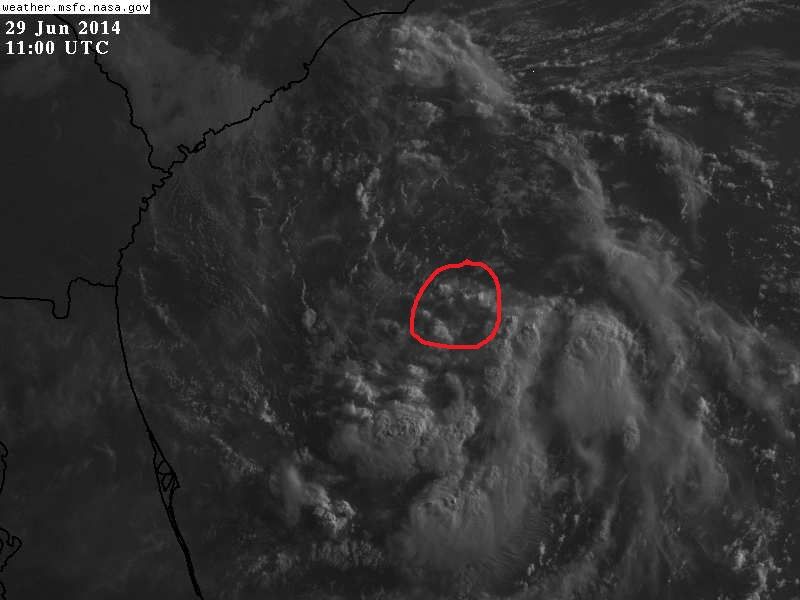
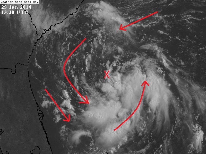
Structure is definitely looking much better compared to yesterday. Starting to see spiral banding and outflow is beginning to also improve. I think 91L is becoming better organized and I expect to see Arthur within the next 24 hours.

I will be interested to see the next set of EURO runs later today. Have to watch this very closely. I am beginning to wonder just how far south 91L will drift and just how close it will get to the coast in the next 72 hours while it meanders around in weak steering currents before getting picked up by the trough swinging through the Ohio Valley by the latter part of this week.
0 likes   
NEVER, EVER SAY NEVER in the tropics and weather in general, and most importantly, with life itself!!

________________________________________________________________________________________

Fay 2008 Beryl 2012 Debby 2012 Colin 2016 Hermine 2016 Julia 2016 Matthew 2016 Irma 2017 Dorian 2019


Return to “2014”

Who is online

Users browsing this forum: No registered users and 115 guests