WPAC: NEOGURI - Post-Tropical

Moderator: S2k Moderators

Message
Author
User avatar
cycloneye
Admin
Admin
Posts: 139049
Age: 67
Joined: Thu Oct 10, 2002 10:54 am
Location: San Juan, Puerto Rico

Re: WPAC: NEOGURI - Typhoon

#241 Postby cycloneye » Sun Jul 06, 2014 7:00 pm

cycloneye wrote:It better turn soon or it slams into Taiwan. The question is when the forecast turn to the north finally occurs.


Well,it looks like the turn to the north is starting.

Image
0 likes   
Visit the Caribbean-Central America Weather Thread where you can find at first post web cams,radars
and observations from Caribbean basin members Click Here

User avatar
xtyphooncyclonex
Category 5
Category 5
Posts: 3688
Age: 22
Joined: Sat Dec 08, 2012 9:07 am
Location: Cebu City
Contact:

#242 Postby xtyphooncyclonex » Sun Jul 06, 2014 7:38 pm

Prayers for Okinawa, as they will have the brunt of a 145 kt super typhoon, the strongest ever possibly to hit the island. As for Mainland Japan, especially Kyushu, this is insane! The JTWC has it as a category 3 typhoon at landfall over the southern main island of Japan.
0 likes   
REMINDER: My opinions that I, or any other NON Pro-Met in this forum, are unofficial. Please do not take my opinions as an official forecast and warning. I am NOT a meteorologist. Following my forecasts blindly may lead to false alarm, danger and risk if official forecasts from agencies are ignored.

User avatar
cycloneye
Admin
Admin
Posts: 139049
Age: 67
Joined: Thu Oct 10, 2002 10:54 am
Location: San Juan, Puerto Rico

Re: WPAC: NEOGURI - Typhoon

#243 Postby cycloneye » Sun Jul 06, 2014 8:02 pm

00z Best Track up to 135kts.

08W NEOGURI 140707 0000 20.4N 128.2E WPAC 135 922
0 likes   
Visit the Caribbean-Central America Weather Thread where you can find at first post web cams,radars
and observations from Caribbean basin members Click Here

hurricanes1234
Category 5
Category 5
Posts: 2903
Joined: Sat Jul 28, 2012 6:19 pm
Location: Trinidad and Tobago

Re: WPAC: NEOGURI - Typhoon

#244 Postby hurricanes1234 » Sun Jul 06, 2014 8:03 pm

cycloneye wrote:00z Best Track up to 135kts.

08W NEOGURI 140707 0000 20.4N 128.2E WPAC 135 922


That's strange! I mean, the cloud tops have warmed around the eye since a few hours ago.
0 likes   
PLEASE NOTE: With the exception of information from weather agencies that I may copy and paste here, my posts will NEVER be official, since I am NOT a meteorologist. They are solely my amateur opinion, and may or may not be accurate. Therefore, please DO NOT use them as official details, particularly when making important decisions. Thank you.

User avatar
xtyphooncyclonex
Category 5
Category 5
Posts: 3688
Age: 22
Joined: Sat Dec 08, 2012 9:07 am
Location: Cebu City
Contact:

#245 Postby xtyphooncyclonex » Sun Jul 06, 2014 8:07 pm

Current OFFICIAL intensity is currently at 95 kts (175 km/h) and 930 hPa.
0 likes   
REMINDER: My opinions that I, or any other NON Pro-Met in this forum, are unofficial. Please do not take my opinions as an official forecast and warning. I am NOT a meteorologist. Following my forecasts blindly may lead to false alarm, danger and risk if official forecasts from agencies are ignored.

User avatar
StormingB81
S2K Supporter
S2K Supporter
Posts: 5676
Age: 42
Joined: Thu Aug 27, 2009 1:45 am
Location: Rockledge, Florida

Re:

#246 Postby StormingB81 » Sun Jul 06, 2014 8:16 pm

xtyphooncyclonex wrote:Current OFFICIAL intensity is currently at 95 kts (175 km/h) and 930 hPa.


95 Knots for the 10 Min and 135 mph for the 1 min.....that's the difference
0 likes   

User avatar
xtyphooncyclonex
Category 5
Category 5
Posts: 3688
Age: 22
Joined: Sat Dec 08, 2012 9:07 am
Location: Cebu City
Contact:

#247 Postby xtyphooncyclonex » Sun Jul 06, 2014 8:33 pm

This has some similarities with typhoon Soulik last year, except that this has a different track, stronger convection and is of course, stronger. The two typhoons (Soulik & Neoguri) were able to survive the dry air, and that they both have large wind fields. Also, a difference is that because of Neoguri having a better structure and stronger convection, this successfully became a super typhoon.
0 likes   
REMINDER: My opinions that I, or any other NON Pro-Met in this forum, are unofficial. Please do not take my opinions as an official forecast and warning. I am NOT a meteorologist. Following my forecasts blindly may lead to false alarm, danger and risk if official forecasts from agencies are ignored.

User avatar
cycloneye
Admin
Admin
Posts: 139049
Age: 67
Joined: Thu Oct 10, 2002 10:54 am
Location: San Juan, Puerto Rico

Re: WPAC: NEOGURI - Typhoon

#248 Postby cycloneye » Sun Jul 06, 2014 8:48 pm

The 0300z warning has Neoguri moving close to the west of Okinawa at 145kts.

Image
0 likes   
Visit the Caribbean-Central America Weather Thread where you can find at first post web cams,radars
and observations from Caribbean basin members Click Here

User avatar
xtyphooncyclonex
Category 5
Category 5
Posts: 3688
Age: 22
Joined: Sat Dec 08, 2012 9:07 am
Location: Cebu City
Contact:

Re: WPAC: NEOGURI - Typhoon

#249 Postby xtyphooncyclonex » Sun Jul 06, 2014 8:50 pm

JTWC 03:00z track has typhoon Neoguri sparing Kadena, and actually, the entire island of Okinawa by a few nautical miles. They will still get strong winds though, as Neoguri has a very large wind field and will be at peak intensity by the time of its closest approach to Kadena, at 145 kts JTWC-105 kts JMA (910 mb pressure as a VIOLENT typhoon) and is still very dangerous, so stay safe Okinawa!
0 likes   
REMINDER: My opinions that I, or any other NON Pro-Met in this forum, are unofficial. Please do not take my opinions as an official forecast and warning. I am NOT a meteorologist. Following my forecasts blindly may lead to false alarm, danger and risk if official forecasts from agencies are ignored.

User avatar
euro6208
Category 5
Category 5
Posts: 18547
Joined: Mon Mar 08, 2004 7:50 pm
Location: Guam

Re: WPAC: NEOGURI - Typhoon

#250 Postby euro6208 » Sun Jul 06, 2014 9:26 pm

very weird looking super typhoon. eye is very well defined and clear cut yet deep convection is somewhat looking compared to past storms near category 5 strength.
0 likes   
Remember, all of my post aren't official. For official warnings and discussions, Please refer to your local NWS products...

NWS for the Western Pacific

https://www.weather.gov/gum/

User avatar
euro6208
Category 5
Category 5
Posts: 18547
Joined: Mon Mar 08, 2004 7:50 pm
Location: Guam

Re: WPAC: NEOGURI - Typhoon

#251 Postby euro6208 » Sun Jul 06, 2014 9:27 pm

135 knots Super Typhoon Neoguri!

WDPN31 PGTW 070300
MSGID/GENADMIN/JOINT TYPHOON WRNCEN PEARL HARBOR HI//
SUBJ/PROGNOSTIC REASONING FOR SUPER TYPHOON 08W (NEOGURI)//
WARNING NR 17//
RMKS//
1. FOR METEOROLOGISTS.
2. 6 HOUR SUMMARY AND ANALYSIS.
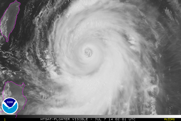
SUPER TYPHOON (STY) 08W (NEOGURI), LOCATED APPROXIMATELY 367 NM
SOUTH OF KADENA AB, OKINAWA, JAPAN, HAS TRACKED NORTHWESTWARD AT 11
KNOTS OVER THE PAST SIX HOURS. ANIMATED MULTISPECTRAL SATELLITE
IMAGERY (MSI) SHOWS THE SYSTEM HAS MAINTAINED AN EXPANSIVE AREAL
COVERAGE AS TIGHTLY CURVED DEEP CONVECTIVE BANDS, MOSTLY FEEDING FROM
THE SOUTHERN FLANK, WRAPPED EVEN TIGHTER INTO A NEW WELL-DEFINED
35-NM EYE. THE 12-HOUR MSI LOOP ALSO SHOWS THE EYEWALL HAS EXPANDED
INTO THIS NEW EYE DIAMETER. THIS IS CAPTURED IN A 062316Z 89 GHZ
SSMIS MICROWAVE IMAGE AS A HIGHLY REFLECTIVE CONVECTIVE RING. THE
INITIAL POSITION IS BASED ON THE MSI ANIMATION AND THE MICROWAVE
IMAGE WITH HIGH CONFIDENCE. THE INITIAL INTENSITY IS AVERAGED
FROM DVORAK ESTIMATES FROM PGTW, KNES, AND RJTD. UPPER LEVEL ANALYSIS
INDICATES THE SYSTEM IS 04 DEGREES SOUTH OF THE RIDGE AXIS IN AN AREA
OF LOW (05-10 KNOT) VERTICAL WIND SHEAR (VWS). ADDITIONALLY, THE
CYCLONE HAS MAINTAINED A MESOSCALE POINT SOURCE THAT IS PROVIDING
HIGHLY-EFFICIENT RADIAL VENTILATION. THIS IS EVIDENT ON ANIMATED
WATER VAPOR IMAGERY. STY 08W CONTINUES TO TRACK ALONG THE SOUTHWEST
EXTENSION OF A DEEP-LAYERED SUBTROPICAL RIDGE (STR) TO THE NORTH.
3. FORECAST REASONING.
A. THERE IS NO CHANGE TO THE FORECAST PHILOSOPHY SINCE THE
PREVIOUS PROGNOSTIC REASONING MESSAGE.
B. STY 08W WILL CONTINUE TO TRACK NORTHWESTWARD THROUGH TAU 12
BEFORE TURNING NORTHWARD AS THE STR RECEDES WITH THE APPROACH OF A
MID-LATITUDE TROUGH FROM THE NORTHWEST. AFTER TAU 24, THE CYCLONE
WILL CREST THE RIDGE AND RECURVE NORTHEASTWARD AS A SECONDARY TROUGH
FURTHER WEAKENS THE STEERING STR. DUE TO VERY FAVORABLE ENVIRONMENTAL
CONDITIONS MENTIONED IN PARA 2, FURTHER INTENSIFICATION IS EXPECTED
OVER THE NEXT 36 HOURS WITH A PEAK OF 145 KNOTS. BEYOND TAU 36,
COOLING SEA SURFACE TEMPERATURES (SST), INCREASING VWS AHEAD OF THE
MID-LATITUDE WESTERLIES, AND LANDFALL INTO KYUSHU, JAPAN, WILL SLOWLY
ERODE THE SYSTEM.
C. AFTER TAU 72, STY NEOGURI WILL COMMENCE EXTRA-TROPICAL
TRANSITION AND ACCELERATE NORTHEASTWARD INTO THE COLD BAROCLINIC
ZONE. THE INCREASED MID-LATITUDE INTERACTION, DECREASING SST, AND
LAND INTERACTION WILL CAUSE ITS RAPID DETERIORATION BEFORE BECOMING A
FULL-FLEDGED COLD CORE LOW BY TAU 120. THE AVAILABLE DYNAMIC MODEL
GUIDANCE REMAINS IN TIGHT AGREEMENT, LENDING HIGH CONFIDENCE TO THE
JTWC TRACK FORECAST WHICH IS POSITIONED CLOSE TO THE MULTI-MODEL
CONSENSUS.//
NNNN
0 likes   
Remember, all of my post aren't official. For official warnings and discussions, Please refer to your local NWS products...

NWS for the Western Pacific

https://www.weather.gov/gum/

dexterlabio
Category 5
Category 5
Posts: 3406
Joined: Sat Oct 24, 2009 11:50 pm

#252 Postby dexterlabio » Sun Jul 06, 2014 9:30 pm

Meanwhile Manila is experiencing the monsoon rain that is being pulled by Neoguri from the west. Typical setup when a typhoon is passing north of the Philippines....
0 likes   
Personal Forecast Disclaimer:
The posts in this forum are NOT official forecast and should not be used as such. They are just the opinion of the poster and may or may not be backed by sound meteorological data. They are NOT endorsed by any professional institution or storm2k.org. For official information, please refer to the NHC and NWS products.

User avatar
euro6208
Category 5
Category 5
Posts: 18547
Joined: Mon Mar 08, 2004 7:50 pm
Location: Guam

Re: WPAC: NEOGURI - Typhoon

#253 Postby euro6208 » Sun Jul 06, 2014 9:34 pm

Image

Some interesting info on Neoguri...
0 likes   
Remember, all of my post aren't official. For official warnings and discussions, Please refer to your local NWS products...

NWS for the Western Pacific

https://www.weather.gov/gum/

User avatar
xtyphooncyclonex
Category 5
Category 5
Posts: 3688
Age: 22
Joined: Sat Dec 08, 2012 9:07 am
Location: Cebu City
Contact:

#254 Postby xtyphooncyclonex » Sun Jul 06, 2014 9:40 pm

And because of the HUGE cloud cover of Neoguri, it is currently overcast here in Cebu. It is also somewhat unusually windy too.
0 likes   
REMINDER: My opinions that I, or any other NON Pro-Met in this forum, are unofficial. Please do not take my opinions as an official forecast and warning. I am NOT a meteorologist. Following my forecasts blindly may lead to false alarm, danger and risk if official forecasts from agencies are ignored.

User avatar
Macrocane
Category 5
Category 5
Posts: 4218
Age: 35
Joined: Sun May 24, 2009 5:35 pm
Location: El Salvador

Re: WPAC: NEOGURI - Typhoon

#255 Postby Macrocane » Sun Jul 06, 2014 9:57 pm

Neoguri's outflow is beautiful

Image

It's really impressive to think that it may still be cat3/cat4 when it reaches Japan.
0 likes   

hurricanes1234
Category 5
Category 5
Posts: 2903
Joined: Sat Jul 28, 2012 6:19 pm
Location: Trinidad and Tobago

#256 Postby hurricanes1234 » Sun Jul 06, 2014 10:06 pm

Just look at that beautiful and enormous eye! I wonder how wide its diameter is...
0 likes   
PLEASE NOTE: With the exception of information from weather agencies that I may copy and paste here, my posts will NEVER be official, since I am NOT a meteorologist. They are solely my amateur opinion, and may or may not be accurate. Therefore, please DO NOT use them as official details, particularly when making important decisions. Thank you.

User avatar
euro6208
Category 5
Category 5
Posts: 18547
Joined: Mon Mar 08, 2004 7:50 pm
Location: Guam

Re: WPAC: NEOGURI - Typhoon

#257 Postby euro6208 » Sun Jul 06, 2014 10:12 pm

Okinawa is a very small island but has the population of a good sized city, 1,384,762 (as of 2009). let's hope this turns away from them...
0 likes   
Remember, all of my post aren't official. For official warnings and discussions, Please refer to your local NWS products...

NWS for the Western Pacific

https://www.weather.gov/gum/

User avatar
xtyphooncyclonex
Category 5
Category 5
Posts: 3688
Age: 22
Joined: Sat Dec 08, 2012 9:07 am
Location: Cebu City
Contact:

#258 Postby xtyphooncyclonex » Sun Jul 06, 2014 10:20 pm

GEM analyzes Typhoon Neoguri as a strong tropical storm. :oops: :roll:
0 likes   
REMINDER: My opinions that I, or any other NON Pro-Met in this forum, are unofficial. Please do not take my opinions as an official forecast and warning. I am NOT a meteorologist. Following my forecasts blindly may lead to false alarm, danger and risk if official forecasts from agencies are ignored.

User avatar
xtyphooncyclonex
Category 5
Category 5
Posts: 3688
Age: 22
Joined: Sat Dec 08, 2012 9:07 am
Location: Cebu City
Contact:

Re: WPAC: NEOGURI - Typhoon

#259 Postby xtyphooncyclonex » Sun Jul 06, 2014 10:22 pm

euro6208 wrote:Okinawa is a very small island but has the population of a good sized city, 1,384,762 (as of 2009). let's hope this turns away from them...

Actually, in the latest JTWC & JMA forecast tracks, Neoguri is WEST of the island of Okinawa, so they may be spared from a direct hit. Yet, its large wind field may bring 100-130 mph winds to Okinawa.
0 likes   
REMINDER: My opinions that I, or any other NON Pro-Met in this forum, are unofficial. Please do not take my opinions as an official forecast and warning. I am NOT a meteorologist. Following my forecasts blindly may lead to false alarm, danger and risk if official forecasts from agencies are ignored.

User avatar
StormingB81
S2K Supporter
S2K Supporter
Posts: 5676
Age: 42
Joined: Thu Aug 27, 2009 1:45 am
Location: Rockledge, Florida

#260 Postby StormingB81 » Sun Jul 06, 2014 10:24 pm

From Space...

Image
0 likes   


Return to “2014”

Who is online

Users browsing this forum: Google Adsense [Bot], MarioProtVI and 34 guests